Great Escarpment, Southern Africa
Videos
Page
The Great Escarpment is a major topographical feature in Africa that consists of steep slopes from the high central Southern African plateau downward in the direction of the oceans that surround southern Africa on three sides. While it lies predominantly within the borders of South Africa, in the east the escarpment extends northward to form the border between Mozambique and Zimbabwe, continuing on beyond the Zambezi river valley to form the Muchinga Escarpment in eastern Zambia. In the west, it extends northward into Namibia and Angola. It is the combination of this escarpment and the aridity of Southern Africa that leads to the lack of navigable rivers in South Africa.
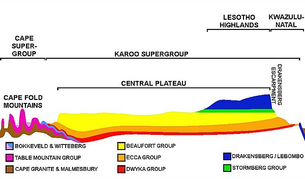
An approximate SW-NE cross section through South Africa with the Cape Peninsula (with Table Mountain) on the far left, and northeastern KwaZulu-Natal on the right is diagrammatic, and only roughly to scale. It shows the major geological structures (coloured layers) that dominate the southern and eastern parts of the country, as well as the relationship between the Central Plateau, the Cape Fold mountains, and the Drakensberg escarpment. The southwestern escarpment (the Roggeberg escarpment) is clearly visible on the left, but is not labelled. The significance and origin of the geological layers can be found under the headings "
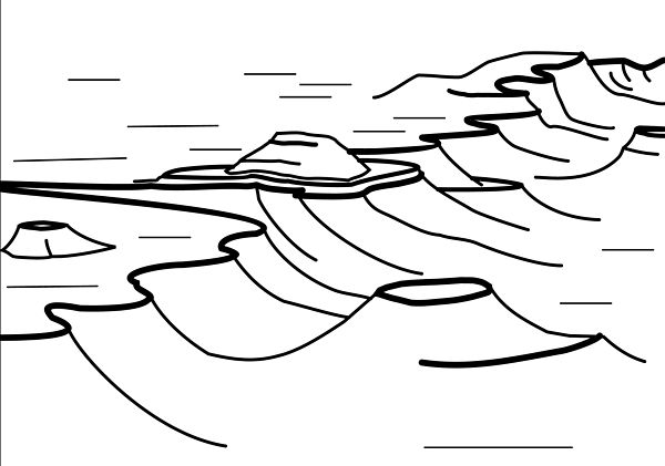
This is a stylized illustration of the Southern African Great Escarpment, based particularly on its appearance in the Great Karoo, where thick erosion resistant dolerite sills (represented by the thick black lines in the diagram) generally form the upper, sharp edge of the escarpment; in other parts of the escarpment hard erosion-resistant geological layers similarly form the upper, abrupt edge (see text); note the island remnants of the earlier extent of the plateau on the plain below the escarpment, left behind as the escarpment has gradually eroded farther inland

A view of the Mpumalanga Drakensberg portion of the Great Escarpment, from God's Window, near Graskop looking south, shows the hard erosion-resistant layer that forms the upper edge of the escarpment that consists of flat-lying quartzite belonging to the Black Reef Formation, which also forms the Magaliesberg mountains near Pretoria.
Escarpment
Videos
Page
An escarpment is a steep slope or long cliff that forms as a result of faulting or erosion and separates two relatively level areas having different elevations.
Shaded and colored image from the Shuttle Radar Topography Mission—shows an elevation model of New Zealand's Alpine Fault running about 500 km (300 mi) long. The escarpment is flanked by a chain of hills squeezed between the fault and the mountains of New Zealand's Southern Alps. Northeast is towards the top.

The Sierra Escarpment in California