Hurricane Lili (1996)
Videos
Page
Hurricane Lili was a relatively long-lived hurricane of the 1996 Atlantic hurricane season that affected countries from Central America to the United Kingdom. Lili formed on October 14 from a tropical wave, which emerged from the coast of west Africa on October 4. After the storm formed, further strengthening of Lili was gradual, first to tropical storm status on October 16 and then to hurricane status on October 17. The next day, Lili struck Cuba and moved across the central portion of the island, the first hurricane to hit the country since Hurricane Kate in 1985. After emerging into the Atlantic Ocean, the hurricane accelerated northeastward, briefly peaking as a category 3 hurricane on the Saffir-Simpson Hurricane Scale near the Bahamas. For almost an entire week, Hurricane Lili oscillated in intensity while fluctuating several times in forward speed. About two weeks passed before Lili transitioned into an extratropical storm north of the Azores on October 27, which subsequently moved across Ireland and Great Britain.

Hurricane Lili over Cuba on October 18
Hurricane Bertha (2014)
Videos
Page
Hurricane Bertha was an unusual tropical cyclone in early August 2014 that attained hurricane status, despite having a disheveled appearance and an abnormally high atmospheric pressure. The third tropical cyclone and second hurricane of the season, Bertha developed from a tropical wave south of Cape Verde was monitored first for possible tropical cyclogenesis on July 26. Over the following days, it slowly developed and acquired gale-force winds and enough convection to be designated as Tropical Storm Bertha early on August 1. A mostly disorganized cyclone, Bertha quickly moved across the Lesser Antilles, clipping the northern end of Martinique, later that day. During its trek across the eastern Caribbean Sea, its circulation became severely disrupted and it may have degenerated into a tropical wave. On August 3, it traversed the Mona Passage and moved over the Southeastern Bahamas where conditions favored development. Despite an overall ragged appearance on satellite imagery, data from Hurricane Hunters indicated it intensified to a hurricane on August 4; it acquired peak winds of 80 mph (130 km/h) that day. Turning north, and later northeast, Bertha soon weakened as it began to merge with an approaching trough to the west. This merger ultimately took place on August 6, at which time Bertha was declared extratropical well to the south of Nova Scotia. The remnant system raced eastward across the Atlantic and later struck the United Kingdom on August 10. Once over the North Sea, the storm stalled for a few days before resuming its eastward track. It was last noted around the Baltic Sea on August 16.
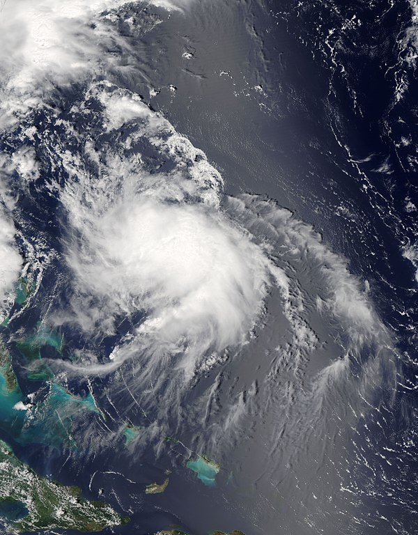
Bertha at peak intensity northeast of the Bahamas on August 4

A disorganized Tropical Storm Bertha approaching Hispaniola on August 2; the convective cloud mass obscures Puerto Rico to the north.

Enhanced surf at Misquamicut, Rhode Island due to Bertha

The extratropical remnant of Bertha over the North Sea, on August 11