Trinity River (Texas)
Videos
Page
The Trinity River is a 710-mile (1,140 km) river, the longest with a watershed entirely within the U.S. state of Texas. It rises in extreme northern Texas, a few miles south of the Red River. The headwaters are separated by the high bluffs on the southern side of the Red River.

Trinity River, Dallas, Texas (postcard, c. 1901–1907)

The Trinity River as viewed from Reunion Tower in Dallas in August 2015

Margaret Hunt Hill Bridge (tall structure in background) at Trinity River as seen in March, 2020

The Trinity River in downtown Fort Worth near West 7th Street.
Texas
Videos
Page
Texas is the most populous state in the South Central region of the United States. It borders Louisiana to the east, Arkansas to the northeast, Oklahoma to the north, New Mexico to the west, and the Mexican states of Chihuahua, Coahuila, Nuevo León, and Tamaulipas to the south and southwest. Texas has a coastline on the Gulf of Mexico to the southeast. Covering 268,596 square miles (695,660 km2), and with over 30 million residents as of 2023, it is the second-largest U.S. state by both area and population.
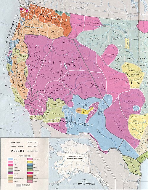
Early Native American tribal territories

Stephen F. Austin was the first American empresario given permission to operate a colony within Mexican Texas.

Surrender of Santa Anna. Painting by William Henry Huddle, 1886.

On March 2, 1936, the U.S. Post Office issued a commemorative stamp commemorating the 100th anniversary of the Texas Declaration of Independence, featuring Sam Houston (left), Stephen Austin and the Alamo.