Aniakchak National Monument and Preserve
Videos
Page
Aniakchak National Monument and Preserve is a U.S. National Monument and National Preserve, consisting of the region around the Aniakchak volcano on the Aleutian Range of south-western Alaska. It has erupted at least 40 times over the last 10,000 years. The 601,294-acre (243,335 ha) monument is one of the least-visited places in the National Park System due to its remote location and difficult weather. The area was proclaimed a National Monument on December 1, 1978, and established as a National Monument and Preserve on December 2, 1980. The National Monument encompasses 137,176 acres (55,513 ha) and the preserve 464,118 acres (187,822 ha). Visitation to Aniakchak is the lowest of all areas of the U.S. National Park System, according to the NPS, with only 100 documented recreational visits in 2017. Most visitors fly into Surprise Lake inside Aniakchak Crater, but the frequent fog and other adverse weather conditions make landing in the lake difficult. It is also possible to fly into the nearby village of Port Heiden and proceed overland to the Aniakchak Crater.

Aerial view of the caldera of Mount Aniakchak from the west

Surprise Lake within the Aniakchak Caldera.
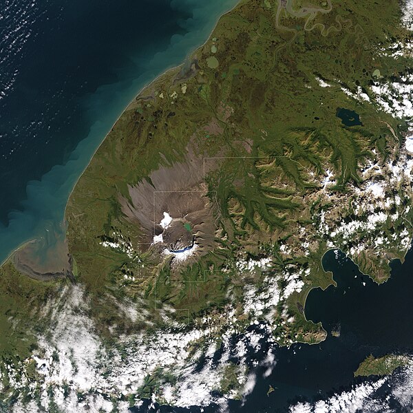
Natural-colour satellite image of Aniakchak National Monument and Preserve.
National preserve
Videos
Page
There are 21 protected areas of the United States designated as national preserves. They were established by an act of Congress to protect areas that have resources often associated with national parks but where certain natural resource-extractive activities such as hunting and mining may be permitted, provided their natural values are preserved. The activities permitted in each national preserve vary depending on the enabling legislation of the unit. All national preserves are managed by the National Park Service (NPS) as part of the National Park System.

Entrance sign to Mojave National Preserve

Entrance sign to Denali National Park and Preserve

Image: Aniakchak Bay (22343282135)

Image: Tors in serpentine valley (9922806545)