Escarpment
Videos
Page
An escarpment is a steep slope or long cliff that forms as a result of faulting or erosion and separates two relatively level areas having different elevations.

Shaded and colored image from the Shuttle Radar Topography Mission—shows an elevation model of New Zealand's Alpine Fault running about 500 km (300 mi) long. The escarpment is flanked by a chain of hills squeezed between the fault and the mountains of New Zealand's Southern Alps. Northeast is towards the top.

The Sierra Escarpment in California
Cliff
Videos
Page
In geography and geology, a cliff is an area of rock which has a general angle defined by the vertical, or nearly vertical. Cliffs are formed by the processes of weathering and erosion, with the effect of gravity. Cliffs are common on coasts, in mountainous areas, escarpments and along rivers. Cliffs are usually composed of rock that is resistant to weathering and erosion. The sedimentary rocks that are most likely to form cliffs include sandstone, limestone, chalk, and dolomite. Igneous rocks such as granite and basalt also often form cliffs.

The White Cliffs of Dover
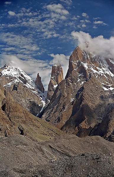
The Trango Towers in Pakistan. Their vertical faces are the world's tallest cliffs. Trango Tower center; Trango Monk center left; Trango II far left; Great Trango right.

The far southwestern aspect of Nanga Parbat's Rupal face, highest cliff (rock wall/mountain face) in the world. The steepest part of the face is 2 km to the northeast.

Vihren’s 460 m north face seen from Golemiya Kazan, Pirin Mountain, Bulgaria