The history of cartography refers to the development and consequences of cartography, or mapmaking technology, throughout human history. Maps have been one of the most important human inventions for millennia, allowing humans to explain and navigate their way through the world.
The world according to Hekatæus, 500 BC
The world according to Anaximenes, c. 500 BC
The world according to Herodotus, 440 BC
Modern version of the Roman Tabula Peutingeriana (5th century).
Cartography is the study and practice of making and using maps. Combining science, aesthetics and technique, cartography builds on the premise that reality can be modeled in ways that communicate spatial information effectively.
Valcamonica rock art (I), Paspardo r. 29, topographic composition, 4th millennium BCE
The Tabula Rogeriana, drawn by Muhammad al-Idrisi for Roger II of Sicily in 1154. South is at the top.
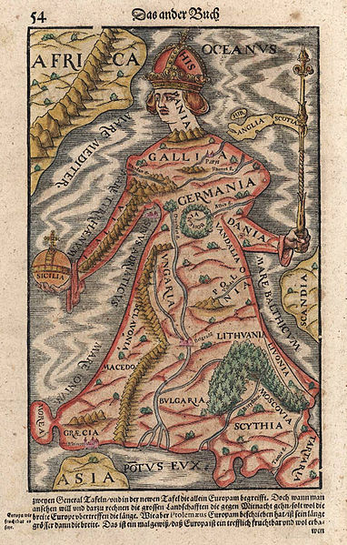
Europa regina in Sebastian Münster's "Cosmographia", 1570
A pre-Mercator nautical chart of 1571, from Portuguese cartographer Fernão Vaz Dourado (c. 1520 – c. 1580). It belongs to the so-called plane chart model, where observed latitudes and magnetic directions are plotted directly into the plane, with a constant scale, as if the Earth were a plane (Portuguese National Archives of Torre do Tombo, Lisbon).