Sand to Snow National Monument
Videos
Page
Sand to Snow National Monument is a U.S. National Monument located in San Bernardino County and northern Riverside County, Southern California.

Sand to Snow National Monument
Coachella Valley
Videos
Page
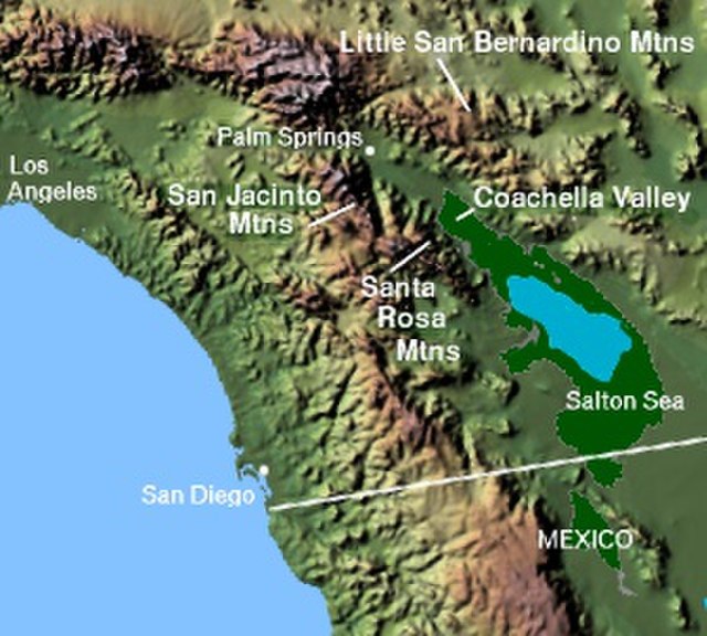
The Coachella Valley is an arid rift valley in the Colorado Desert of Southern California in Riverside County. The valley has been referred to as Greater Palm Springs and occasionally the Palm Springs Area due to the historic prominence of the city of Palm Springs. The valley extends approximately 45 mi (72 km) southeast from the San Gorgonio Pass to the northern shore of the Salton Sea and the neighboring Imperial Valley, and is approximately 15 mi (24 km) wide along most of its length. It is bounded on the northeast by the San Bernardino and Little San Bernardino Mountains, and on the southwest by the San Jacinto and Santa Rosa Mountains.
Coachella Valley

Panorama of the view south from Keys View in the Little San Bernardino Mountains, Joshua Tree National Park, California, United States. Visible landmarks are the Salton Sea, 230 feet (70 m) below sea level at rear left, along towards the center the Santa Rosa Mountains behind Indio and the San Jacinto Mountains behind Palm Springs. In the valley floor, the San Andreas Fault is clearly visible. At the rear right is the 11,500-foot tall (3,500 m) San Gorgonio Mountain.

The San Gorgonio Pass Wind Farm as viewed from the top of the Palm Springs Aerial Tramway in the San Jacinto Mountains to the south