1.
Amsterdam Island (Spitsbergen)
–
Amsterdam Island is a small island off the northwest coast of West-Spitsbergen. It is separated from Danes Island by the strait Danskegattet, area covered with ice, ca.11,5 %. Amsterdam Island was first seen by Willem Barents in 1596, the Dutch first occupied it in 1614, building a temporary whaling station on the islands southeastern promontory. In 1619 a semi-permanent station was constructed and it came to be called Smeerenburg. The settlement went into decline in the 1640s, and was abandoned sometime before 1660, no Man’s Land, A History of Spitsbergen from Its Discovery in 1596 to the Beginning of the Scientific Exploration of the Country. Norwegian Polar Institute Place Names of Svalbard Database
2.
La Marseillaise
–
La Marseillaise is the national anthem of France. The song was written in 1792 by Claude Joseph Rouget de Lisle in Strasbourg after the declaration of war by France against Austria, and was originally titled Chant de guerre pour lArmée du Rhin. The Marseillaise was a song, an anthem to freedom, a patriotic call to mobilize all the citizens. The French National Convention adopted it as the Republics anthem in 1795 and it acquired its nickname after being sung in Paris by volunteers from Marseille marching to the capital. The song is the first example of the European march anthemic style, the anthems evocative melody and lyrics have led to its widespread use as a song of revolution and its incorporation into many pieces of classical and popular music. As the French Revolution continued, the monarchies of Europe became concerned that revolutionary fervor would spread to their countries, the War of the First Coalition was an effort to stop the revolution, or at least contain it to France. Initially, the French army did not distinguish itself, and Coalition armies invaded France and that evening, Rouget de Lisle wrote Chant de guerre pour lArmée du Rhin, and dedicated the song to Marshal Nicolas Luckner, a Bavarian in French service from Cham. A plaque on the building on Place Broglie where De Dietrichs house once stood commemorates the event. The melody soon became the call to the French Revolution and was adopted as La Marseillaise after the melody was first sung on the streets by volunteers from Marseille by the end of May. A newly graduated medical doctor, Mireur later became a general under Napoléon Bonaparte, the songs lyric reflects the invasion of France by foreign armies that were under way when it was written. Strasbourg itself was attacked just a few days later, the invading forces were repulsed from France following their defeat in the Battle of Valmy. As the vast majority of Alsatians did not speak French, a German version was published in October 1792 in Colmar, the Convention accepted it as the French national anthem in a decree passed on 14 July 1795, making it Frances first anthem. It later lost this status under Napoleon I, and the song was banned outright by Louis XVIII and Charles X, only being re-instated briefly after the July Revolution of 1830. During Napoleon Is reign, Veillons au Salut de lEmpire was the anthem of the regime. Eight years later, in 1879, it was restored as Frances national anthem, several musical antecedents have been cited for the melody, Mozarts Allegro maestoso of Piano Concerto No. Only the first verse and the first chorus are sung today in France, there are some slight historical variations in the lyrics of the song, the following is the version listed at the official website of the French Presidency. Verses sung in the version of the anthem are in bold. The United States Library of Congress holds the following English translation and these verses were omitted from the national anthem
3.
France
–
France, officially the French Republic, is a country with territory in western Europe and several overseas regions and territories. The European, or metropolitan, area of France extends from the Mediterranean Sea to the English Channel and the North Sea, Overseas France include French Guiana on the South American continent and several island territories in the Atlantic, Pacific and Indian oceans. France spans 643,801 square kilometres and had a population of almost 67 million people as of January 2017. It is a unitary republic with the capital in Paris. Other major urban centres include Marseille, Lyon, Lille, Nice, Toulouse, during the Iron Age, what is now metropolitan France was inhabited by the Gauls, a Celtic people. The area was annexed in 51 BC by Rome, which held Gaul until 486, France emerged as a major European power in the Late Middle Ages, with its victory in the Hundred Years War strengthening state-building and political centralisation. During the Renaissance, French culture flourished and a colonial empire was established. The 16th century was dominated by civil wars between Catholics and Protestants. France became Europes dominant cultural, political, and military power under Louis XIV, in the 19th century Napoleon took power and established the First French Empire, whose subsequent Napoleonic Wars shaped the course of continental Europe. Following the collapse of the Empire, France endured a succession of governments culminating with the establishment of the French Third Republic in 1870. Following liberation in 1944, a Fourth Republic was established and later dissolved in the course of the Algerian War, the Fifth Republic, led by Charles de Gaulle, was formed in 1958 and remains to this day. Algeria and nearly all the colonies became independent in the 1960s with minimal controversy and typically retained close economic. France has long been a centre of art, science. It hosts Europes fourth-largest number of cultural UNESCO World Heritage Sites and receives around 83 million foreign tourists annually, France is a developed country with the worlds sixth-largest economy by nominal GDP and ninth-largest by purchasing power parity. In terms of household wealth, it ranks fourth in the world. France performs well in international rankings of education, health care, life expectancy, France remains a great power in the world, being one of the five permanent members of the United Nations Security Council with the power to veto and an official nuclear-weapon state. It is a member state of the European Union and the Eurozone. It is also a member of the Group of 7, North Atlantic Treaty Organization, Organisation for Economic Co-operation and Development, the World Trade Organization, originally applied to the whole Frankish Empire, the name France comes from the Latin Francia, or country of the Franks
4.
New Amsterdam
–
New Amsterdam was a 17th-century Dutch settlement established at the southern tip of Manhattan Island, which served as the seat of the colonial government in New Netherland. The factorij became a settlement outside of Fort Amsterdam, situated on the strategic, fortifiable southern tip of the island of Manhattan, the fort was meant to defend the Dutch West India Companys fur trade operations in the North River. In 1624 it became an extension of the Dutch Republic and was designated as the capital of the province in 1625. New Amsterdam was renamed New York on September 8,1664, in honor of the then Duke of York, Hudson named the river the Mauritius River. He was covertly attempting to find the Northwest Passage for the Dutch East India Company, instead, he brought back news about the possibility of exploitation of beaver by the Dutch who sent commercial, private missions to the area the following years. At the time, beaver pelts were prized in Europe. A by-product of the trade in beaver pelts was castoreum—the secretion of the animals anal glands—which was used for its medicinal properties and for perfumes. The expeditions by Adriaen Block and Hendrick Christiaensen in 1611,1612,1613 and 1614 resulted in the surveying and charting of the region from the 38th parallel to the 45th parallel. On their 1614 map, which gave them a trade monopoly under a patent of the States General. It also showed the first year-round trading presence in New Netherland, Fort Nassau, which would be replaced in 1624 by Fort Orange and he was the first recorded non-Native American inhabitant of what would eventually become New York City. The territory of New Netherland was originally a private, profit-making commercial enterprise focusing on cementing alliances, surveying and exploration of the region was conducted as a prelude to an anticipated official settlement by the Dutch Republic, which occurred in 1624. In 1620 the Pilgrims attempted to sail to the Hudson River from England, however, the Mayflower reached Cape Cod on November 9,1620, after a voyage of 64 days. For a variety of reasons, primarily a shortage of supplies, the Mayflower could not proceed to the Hudson River, here American Indian hunters supplied them with pelts in exchange for European-made trade goods and wampum, which was soon being made by the Dutch on Long Island. In 1621 the Dutch West India Company was founded, between 1621 and 1623, orders were given to the private, commercial traders to vacate the territory, thus opening up the territory to Dutch settlers and company traders. It also allowed the laws and ordinances of the states of Holland to apply, previously, during the private, commercial period, only the law of the ship had applied. A fort and sawmill were erected at Nut Island. The latter was constructed by Franchoys Fezard, and was taken apart for iron in 1648, the threat of attack from other European colonial powers prompted the directors of the Dutch West India Company to formulate a plan to protect the entrance to the Hudson River. By the end of 1625, the site had been staked out directly south of Bowling Green on the site of the present U. S, the Mohawk-Mahican War in the Hudson Valley led the company to relocate even more settlers to the vicinity of the new Fort Amsterdam
5.
New York City
–
The City of New York, often called New York City or simply New York, is the most populous city in the United States. With an estimated 2015 population of 8,550,405 distributed over an area of about 302.6 square miles. Located at the tip of the state of New York. Home to the headquarters of the United Nations, New York is an important center for international diplomacy and has described as the cultural and financial capital of the world. Situated on one of the worlds largest natural harbors, New York City consists of five boroughs, the five boroughs – Brooklyn, Queens, Manhattan, The Bronx, and Staten Island – were consolidated into a single city in 1898. In 2013, the MSA produced a gross metropolitan product of nearly US$1.39 trillion, in 2012, the CSA generated a GMP of over US$1.55 trillion. NYCs MSA and CSA GDP are higher than all but 11 and 12 countries, New York City traces its origin to its 1624 founding in Lower Manhattan as a trading post by colonists of the Dutch Republic and was named New Amsterdam in 1626. The city and its surroundings came under English control in 1664 and were renamed New York after King Charles II of England granted the lands to his brother, New York served as the capital of the United States from 1785 until 1790. It has been the countrys largest city since 1790, the Statue of Liberty greeted millions of immigrants as they came to the Americas by ship in the late 19th and early 20th centuries and is a symbol of the United States and its democracy. In the 21st century, New York has emerged as a node of creativity and entrepreneurship, social tolerance. Several sources have ranked New York the most photographed city in the world, the names of many of the citys bridges, tapered skyscrapers, and parks are known around the world. Manhattans real estate market is among the most expensive in the world, Manhattans Chinatown incorporates the highest concentration of Chinese people in the Western Hemisphere, with multiple signature Chinatowns developing across the city. Providing continuous 24/7 service, the New York City Subway is one of the most extensive metro systems worldwide, with 472 stations in operation. Over 120 colleges and universities are located in New York City, including Columbia University, New York University, and Rockefeller University, during the Wisconsinan glaciation, the New York City region was situated at the edge of a large ice sheet over 1,000 feet in depth. The ice sheet scraped away large amounts of soil, leaving the bedrock that serves as the foundation for much of New York City today. Later on, movement of the ice sheet would contribute to the separation of what are now Long Island and Staten Island. The first documented visit by a European was in 1524 by Giovanni da Verrazzano, a Florentine explorer in the service of the French crown and he claimed the area for France and named it Nouvelle Angoulême. Heavy ice kept him from further exploration, and he returned to Spain in August and he proceeded to sail up what the Dutch would name the North River, named first by Hudson as the Mauritius after Maurice, Prince of Orange
6.
United States
–
Forty-eight of the fifty states and the federal district are contiguous and located in North America between Canada and Mexico. The state of Alaska is in the northwest corner of North America, bordered by Canada to the east, the state of Hawaii is an archipelago in the mid-Pacific Ocean. The U. S. territories are scattered about the Pacific Ocean, the geography, climate and wildlife of the country are extremely diverse. At 3.8 million square miles and with over 324 million people, the United States is the worlds third- or fourth-largest country by area, third-largest by land area. It is one of the worlds most ethnically diverse and multicultural nations, paleo-Indians migrated from Asia to the North American mainland at least 15,000 years ago. European colonization began in the 16th century, the United States emerged from 13 British colonies along the East Coast. Numerous disputes between Great Britain and the following the Seven Years War led to the American Revolution. On July 4,1776, during the course of the American Revolutionary War, the war ended in 1783 with recognition of the independence of the United States by Great Britain, representing the first successful war of independence against a European power. The current constitution was adopted in 1788, after the Articles of Confederation, the first ten amendments, collectively named the Bill of Rights, were ratified in 1791 and designed to guarantee many fundamental civil liberties. During the second half of the 19th century, the American Civil War led to the end of slavery in the country. By the end of century, the United States extended into the Pacific Ocean. The Spanish–American War and World War I confirmed the status as a global military power. The end of the Cold War and the dissolution of the Soviet Union in 1991 left the United States as the sole superpower. The U. S. is a member of the United Nations, World Bank, International Monetary Fund, Organization of American States. The United States is a developed country, with the worlds largest economy by nominal GDP. It ranks highly in several measures of performance, including average wage, human development, per capita GDP. While the U. S. economy is considered post-industrial, characterized by the dominance of services and knowledge economy, the United States is a prominent political and cultural force internationally, and a leader in scientific research and technological innovations. In 1507, the German cartographer Martin Waldseemüller produced a map on which he named the lands of the Western Hemisphere America after the Italian explorer and cartographer Amerigo Vespucci
7.
Indian Ocean
–
The Indian Ocean is the third largest of the worlds oceanic divisions, covering 70,560,000 km2. It is bounded by Asia on the north, on the west by Africa, on the east by Australia, the Indian Ocean is known as Ratnākara, the mine of gems in ancient Sanskrit literature, and as Hind Mahāsāgar, in Hindi. The northernmost extent of the Indian Ocean is approximately 30° north in the Persian Gulf, the oceans continental shelves are narrow, averaging 200 kilometres in width. An exception is found off Australias western coast, where the width exceeds 1,000 kilometres. The average depth of the ocean is 3,890 m and its deepest point is Diamantina Deep in Diamantina Trench, at 8,047 m deep, Sunda Trench has a depth of 7, 258–7,725 m. North of 50° south latitude, 86% of the basin is covered by pelagic sediments. The remaining 14% is layered with terrigenous sediments, glacial outwash dominates the extreme southern latitudes. The major choke points include Bab el Mandeb, Strait of Hormuz, the Lombok Strait, the Strait of Malacca, the Indian Ocean is artificially connected to the Mediterranean Sea through the Suez Canal, which is accessible via the Red Sea. All of the Indian Ocean is in the Eastern Hemisphere and the centre of the Eastern Hemisphere is in this ocean, marginal seas, gulfs, bays and straits of the Indian Ocean include, The climate north of the equator is affected by a monsoon climate. Strong north-east winds blow from October until April, from May until October south, in the Arabian Sea the violent Monsoon brings rain to the Indian subcontinent. In the southern hemisphere, the winds are milder. When the monsoon winds change, cyclones sometimes strike the shores of the Arabian Sea, the Indian Ocean is the warmest ocean in the world. Long-term ocean temperature records show a rapid, continuous warming in the Indian Ocean, Indian Ocean warming is the largest among the tropical oceans, and about 3 times faster than the warming observed in the Pacific. Research indicates that human induced greenhouse warming, and changes in the frequency, among the few large rivers flowing into the Indian Ocean are the Zambezi, Shatt al-Arab, Indus, Godavari, Krishna, Narmada, Ganges, Brahmaputra, Jubba and Irrawaddy River. The oceans currents are controlled by the monsoon. Two large gyres, one in the northern hemisphere flowing clockwise and one south of the equator moving anticlockwise, during the winter monsoon, however, currents in the north are reversed. Deep water circulation is controlled primarily by inflows from the Atlantic Ocean, the Red Sea, north of 20° south latitude the minimum surface temperature is 22 °C, exceeding 28 °C to the east. Southward of 40° south latitude, temperatures drop quickly, surface water salinity ranges from 32 to 37 parts per 1000, the highest occurring in the Arabian Sea and in a belt between southern Africa and south-western Australia
8.
French Southern and Antarctic Lands
–
The French Southern and Antarctic Lands is an overseas territory of France. It consists of, Kerguelen Islands, a group of islands in the southern Indian Ocean, southeast of Africa. The territory is called the French Southern Lands or French Southern Territories. The latter excludes Adélie Land, where French sovereignty is not widely recognized, the lands are not connected to France Antarctique, a former French colony in Brazil. The territory has no permanent civilian population and those resident consist of visiting military personnel, officials, scientific researchers and support staff. The French Southern and Antarctic Lands have formed a territoire doutre-mer of France since 1955, the territory is divided into five districts, a According to new law 2007-224 of February 21,2007, the Scattered Islands constitute the TAAFs fifth district. The TAAF website does not mention their population, the data are not included in the totals. b The Îles Éparses principal station is on Tromelin. The headquarters of the district chief lies beyond the TAAF, in Saint Pierre on Réunion Island. c The Territorys principal station is Martin-de-Viviès on Île Amsterdam, the capital and headquarters of the Territorial administrator lies beyond the TAAF, in Saint Pierre on Réunion Island. Each district is headed by a chief, who has powers similar to those of a French mayor. Because there is no permanent population, there is no elected assembly, Adélie Land and the islands, totaling 7,781 km2, have no indigenous inhabitants, though in 1997 there were about 100 researchers whose numbers varied from winter to summer. Île Amsterdam and Île Saint-Paul are extinct volcanoes and have been delineated as the Amsterdam, the highest point in the territory is Mont Ross on Île Kerguelen at 1,850 m. There are very few airstrips on the islands, only existing on islands with weather stations, the islands in the Indian Ocean are supplied by the special ship Marion Dufresne sailing out of Le Port in Réunion Island. Terre Adélie is supplied by Astrolabe sailing out of Hobart in Tasmania and this register, however, is to vanish, replaced by the International French Register. The territory contains the land mass that is antipodal to the Contiguous United States. Île Amsterdam and Île Saint-Paul lie antipodal to two areas in south-eastern Colorado, near the cities of Lamar and Cheyenne Wells, respectively. The territorys natural resources are limited to fish and crustaceans, economic activity is limited to servicing meteorological and geophysical research stations and French and other fishing fleets. The main fish resources are Patagonian toothfish and spiny lobster, both are poached by foreign fleets, because of this, the French Navy and occasionally other services patrol the zone and arrest poaching vessels. Such arrests can result in heavy fines and/or the seizure of the ship, France used to sell licenses to foreign fisheries to fish the Patagonian toothfish, because of overfishing, it is now restricted to a small number of fisheries from Réunion Island
9.
Research station
–
A research station is a station that is built for the purpose of conducting scientific research. Research station sites might include areas of the world, oceans, as well as outer space. Some research stations are located in the Arctic, such as the Northeast Science Station, McGill Arctic Research Station, some stations in the Arctic are manned drifting ice stations, built on the ice of the high latitudes of the Arctic Ocean. Many nations also have stations located in Antarctica, Showa Station, Halley. Research stations in Antarctica List of research stations in the Arctic Media related to Category, Scientific stations at Wikimedia Commons
10.
Spaniards
–
Within Spain there are a number of nationalisms and regionalisms, reflecting the countrys complex history and diverse culture. There are several commonly spoken languages, most notably Basque. There are many populations outside Spain with ancestors who emigrated from Spain, the Roman Republic conquered Iberia during the 2nd and 1st centuries BC. As a result of Roman colonization, the majority of languages, with the exception of Basque. The Germanic Vandals and Suebi, with part of the Iranian Alans under King Respendial conquered the peninsula in 409 AD. The Iberian Peninsula was conquered and brought under the rule of the Arab Umayyads in 711 and by the Berber North African dynasties the Almohads, in the early 16th century the Kingdom of Navarre was also conquered. In parallel, a wave of emigration began to the Americas began with over 16 million people emigrating to the Americas during the colonial period. In the post-colonial period, a further 3.5 million Spanish left for the Americas, particularly Argentina, Uruguay, Mexico, Brazil, Chile, Venezuela, Puerto Rico, as a result, Spanish-descendants in Latin America number in the hundreds of millions. Spain is home to one of the largest communities of Romani people, the Spanish Roma, which belong to the Iberian Kale subgroup, are a formerly-nomadic community, which spread across Western Asia, North Africa, and Europe, first reaching Spain in the 15th century. The population of Spain is became increasingly diverse due to recent immigration, the earliest modern humans inhabiting Spain are believed to have been Neolithic peoples who may have arrived in the Iberian Peninsula as early as 35, 000–40,000 years ago. In more recent times the Iberians are believed to have arrived or developed in the region between the 4th millennium BC and the 3rd millennium BC, initially settling along the Mediterranean coast, celts settled in Spain during the Iron Age. Some of those tribes in North-central Spain, which had contact with the Iberians, are called Celtiberians. In addition, a known as the Tartessians and later Turdetanians inhabited southwestern Spain. The seafaring Phoenicians, Greeks, and Carthaginians successively founded trading colonies along the Mediterranean coast over a period of several centuries, the Second Punic War between the Carthaginians and Romans was fought mainly in what is now Spain and Portugal. The Roman Republic conquered Iberia during the 2nd and 1st centuries BC transformed most of the region into a series of Latin-speaking provinces, hispania emerged as an important part of the Roman Empire and produced notable historical figures such as Trajan, Hadrian, Seneca and Quintilian. The Germanic Vandals and Suebi, with part of the Iranian Alans under King Respendial, the Suebi became the first Germanic kingdom to convert officially to Roman Catholicism in 447 AD. under king Rechiar. After two centuries of domination by the Visigothic Kingdom, the Iberian Peninsula was invaded by a Muslim force under Tariq Bin Ziyad in 711 and this army consisted mainly ethnic Berbers from the Ghomara tribe, which were reinforced by Arabs from Syria once the conquest was complete. Muslim Iberia became part of the Umayyad Caliphate and would be known as Al-Andalus, the Berbers of Al Andalus revolted as early as 740 AD, halting Arab expansion across the Pyrenees into France
11.
Circumnavigation
–
Circumnavigation means to travel all the way around the entire planet, or an island, or continent. This article is concerned with circumnavigation of the Earth, the first known circumnavigation of Earth was the Magellan-Elcano expedition, which sailed from Seville, Spain, in 1519 and returned in 1522 after crossing the Atlantic, Pacific and Indian oceans. The word circumnavigation is a formed from the verb circumnavigate, from the past participle of the Latin verb circumnavigare. If a person walks completely around either Pole, they cross all meridians, the trajectory of a true circumnavigation forms a continuous loop on the surface of Earth separating two halves of comparable area. A basic definition of a global circumnavigation would be a route which covers roughly a great circle, in practice, people use different definitions of world circumnavigation to accommodate practical constraints, depending on the method of travel. The first single voyage of global circumnavigation was that of the ship Victoria and it was a Castilian voyage of discovery, led initially by Ferdinand Magellan between 1519 and 1521, and then by the Basque 
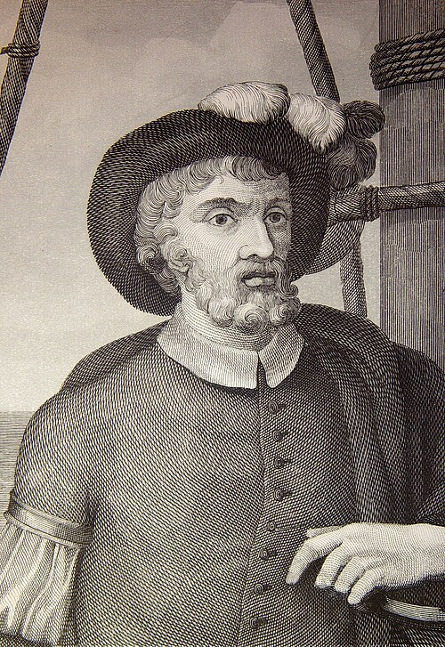
Juan Sebastián Elcano from 1521 to 1522. It then continued across the Pacific discovering a number of islands on its way, Elcano and a small group of 18 men were actually the only members of the expedition to make the full circumnavigation. However, traveling west from Europe, in 1521, Magellan reached a region of Southeast Asia, Magellan thereby achieved a nearly complete personal circumnavigation of the globe for the first time in history. In 1577, Elizabeth I sent Francis Drake to start an expedition against the Spanish along the Pacific coast of the Americas, Drake set out from Plymouth, England in November 1577, aboard Pelican, which Drake renamed Golden Hind mid-voyage. In June 1579, Drake landed somewhere north of Spains northern-most claim in Alta California, Drake completed the second circumnavigation of the world in September 1580, becoming the first commander to lead an entire circumnavigation. For the wealthy, long voyages around the world, such as was done by Ulysses S. Grant, became possible in the 19th century, however, it was later improvements in technology and rising incomes that made such trips relatively common. The nautical global circumnavigation record is held by a wind-powered vessel. It can be seen that the route roughly approximates a great circle, in yacht racing, a round-the-world route approximating a great circle would be quite impractical, particularly in a non-stop race where use of the Panama and Suez Canals would be impossible. The second map on the shows the route of the Vendée Globe round-the-world race in red. It can be seen that the route does not pass through any pairs of antipodal points and it is allowed to have one single waypoint to lengthen the calculated track. The voyage followed the North Atlantic Ocean, Equator, South Atlantic Ocean, Southern Ocean, South Atlantic Ocean, Equator, since the advent of world cruises in 1922, by Cunards Laconia, thousands of people have completed circumnavigations of the globe at a more leisurely pace. Typically, these voyages begin in New York City or Southampton, routes vary, either travelling through the Caribbean and then into the Pacific Ocean via the Panama Canal, or around Cape Horn. From there ships usually make their way to Hawaii, the islands of the South Pacific, Australia, New Zealand, then northward to Hong Kong, South East Asia, and India
12.
Anthony van Diemen
–
Anthony van Diemen was a Dutch colonial governor. He was born in Culemborg in the Netherlands, the son of Meeus Anthonisz van Diemen, in 1616 he moved to Amsterdam, in hope of improving his fortune as a merchant, in this he failed and was declared bankrupt. After a year he became a servant of the Dutch East India Company and sailed to Batavia, Dutch East Indies, on the voyage out, the East Indiaman Mauritius inadvertently put in on unknown coast of Australia. Governor Jan Pieterszoon Coen found van Diemen to be an official and by 1626 he was Director-General of Commerce. In 1630 he married Maria van Aelst, a year later he returned to the Netherlands as Admiral on the ship Deventer. In 1632 he returned to Batavia and in 1635 he was appointed Governor-General of the Dutch East Indies, Van Diemens nine years as Governor-General were successful and important for both the colony and the commercial success of the Dutch East India Company. He devoted much of his energy to expanding the power of the company throughout South-East Asia, under his rule Dutch power was established in Ceylon via Trincomalee. Van Diemen is best remembered for his efforts to foster exploration of the Great South Land, Australia, resulting in the final, undeterred, Van Diemen appointed Frans Visscher to draw up a plan for new discoveries. Tasman sent a party ashore at Blackman Bay, on the Tasman Peninsula, believing he had found a large territory, Tasman named it Van Diemens Land in honour of his patron. Van Diemen is also commemorated in Van Diemen Gulf on the coast of northern Australia and he commissioned a further voyage from Tasman in 1644. Van Diemen died in 1645 in Batavia, Dutch East Indies, the company granted his wife a large pension and she retired to the Netherlands. Her name is perpetuated in the name of the westernmost point of the North Island of New Zealand, Cape Maria van Diemen, named by Tasman in 1643 and it is one of only two geographical locations in New Zealand to have the name Tasman gave them. The other being Three Kings Islands, in 1842 the venomous Australian and southern Papuan, elapid snake genus Demansia was named in honour of van Diemen by J. E. Gray of the British Museum in London. Anthony van Diemen, From Bankrupt to Governor-General, 1593-1636, The Great Circle, anthony van Diemen, Patron of Discovery and Exploration, 1636-45, The Great Circle, Journal of the Australian Association of Maritime History,27.1
13.
Willem de Vlamingh
–
Willem Hesselsz de Vlamingh was a Dutch sea-captain who explored the central west coast of Australia in the late 17th century. The mission proved fruitless, but Vlamingh charted parts of the western coast. Willem de Vlamingh was born in Oost-Vlieland in the Dutch Republic and he was baptised on 28 November 1640. In 1664 De Vlamingh sailed to Nova Zembla and discovered Jelmerland, in 1668 he married, his profession was skipper in whaling, and he still lived on the island Vlieland. In 1687 he and his wife sold their apartment in the Jordaan, De Vlamingh joined the VOC in 1688 and made his first voyage to Batavia in the same year. VOC officials believed it might have run aground on the west coast of Terra Australis, the expedition departed Texel stricly incognito on 3 May 1696 and, because of the Nine Years War with France, sailed around the coast of Scotland to Tristan de Cunha. Early September the three arrived at Cape of Good Hope, where they stayed for seven weeks because of scurvy among the crew. On 27 October they left, using the Brouwer Route on the Indian Ocean route from the African Cape of Good Hope to the Dutch East Indies, on their way east they checked Île Saint-Paul and Île Amsterdam, but no wreckage or survivors were found. On 5 December they sailed on, on 29 December 1696, de Vlaminghs party landed on Rottnest Island. He saw a giant jarrah, numerous quokkas, and thinking they were large rats he named the rats nest because of them. There is plentiful salt, and the coast is full of fish, birds make themselves heard with pleasant song in these scented groves. On 10 January 1697, he ventured up the Swan River and he and his crew are believed to have been the first Europeans to do so. They are also assumed to be the first Europeans to see black swans, the crew split into three parties, hoping to catch an Aborigine, but about five days later they gave up their quest to catch a South lander. On 22 January the sailed through the Geelvink Channel, the next days they saw ten naked, black people. On 24 January they passed Red Bluff, near Wittecarra they went looking for fresh water. The original plate is preserved in the Rijksmuseum in Amsterdam, De Vlamingh, with his son and Collaert, commanded a return fleet from the Indies on 3 or 11 February 1698, which arrived in his hometown, Amsterdam, on 16 August. However, it is not certain that De Vlamingh was still alive at that point, on an earlier retourship, De Vlamingh had sent Witsen a box with seashells, fruits and vegetation from New Holland, as well as eleven drawings that Victor Victorsz had made on the expedition. De Vlamingh also included some black swans, but they died on the voyage, Witsen offered the drawings to Martin Lister
14.
Barque
–
A barque, barc, or bark is a type of sailing vessel with three or more masts having the fore- and mainmasts rigged square and only the mizzen rigged fore-and-aft. The word barque entered English via French, which in came from the Latin barca by way of Occitan. The Latin barca may stem from Celtic barc or Greek baris, the Oxford English Dictionary considers the latter improbable. The word barc appears to have come from Celtic languages, the form adopted by English, perhaps from Irish, was bark, while that adopted by Latin as barca very early, which gave rise to the French barge and barque. In Latin, Spanish and Italian the term refers to a small boat. French influence in England led to the use in English of both words, although their meanings now are not the same, well before the 19th century a barge had become interpreted as a small vessel of coastal or inland waters. Somewhat later, a became a sailing vessel of a distinctive rig as detailed below. In Britain, by the century, the spelling had taken on the French form of barque. Francis Bacon used this form of the word as early as 1592, throughout the period of sail, the word was used also as a shortening of the barca-longa of the Mediterranean Sea. The usual convention is that spelling barque refers to a ship and bark to tree hide, barcarole in music shares the same etymology, being originally a folk song sung by Venetian gondolier and derived from barca - boat in Italian. In the 18th century, the British Royal Navy used the bark for a nondescript vessel that did not fit any of its usual categories. She happened to be a sailing vessel with a plain bluff bow. Our Northern Mariners, who are trained in the coal-trade, apply this distinction to a broad-sterned ship, hon. the Earl of Sussex, Lord Deputy of Ireland. By the end of the 18th century, the term came to refer to any vessel with a particular type of sail-plan. This comprises three masts, fore-and-aft sails on the aftermost mast and square sails on all other masts, barques were the workhorse of the Golden Age of Sail in the mid-19th century as they attained passages that nearly matched full rigged ships but could operate with smaller crews. Conversely, the ship rig tended to be retained for training vessels where the larger the crew, another advantage is that a barque can outperform a schooner or barkentine, and is both easier to handle and better at going to windward than a full-rigged ship. Usually the main mast was the tallest, that of Moshulu extends to 58 m off the deck, the four-masted barque can be handled with a surprisingly small crew—at minimum, ten—and while the usual crew was around thirty, almost half of them could be apprentices. Today many sailing ships are barques
15.
Schooner
–
A schooner /ˈskuːnər/ is a type of sailing vessel with fore-and-aft sails on two or more masts, the foremast being shorter than the main and no taller than the mizzen if there is one. While the schooner was originally gaff-rigged, modern schooners typically carry a Bermuda rig, such vessels were first used by the Dutch in the 16th or 17th century. They were further developed in North America from the early 18th century, the most common type, with two masts, were popular in trades requiring speed and windward ability, such as slaving, privateering, blockade running, and offshore fishing. In the Chesapeake Bay area several distinctive schooner types evolved, including the Baltimore clipper, bugeye, schooners were also popular among pirates in the West Indies during the Golden Age of Piracy, for their speed and agility. They could also sail in shallow waters, and while being smaller than other ships of the time period. Schooners first evolved in the late 17th century from a variety of small two-masted gaff-rigged vessels used in the coast, most were working craft but some pleasure yachts with schooner rigs were built for wealthy merchants and Dutch nobility. Following the arrival of the Dutch monarch William of Orange on the British throne and this vessel, captured in a detailed Admiralty model, is the earliest fully documented schooner. Royal Transport was quickly noted for its speed and ease of handling, North American shipbuilders quickly developed a variety of schooner forms for trading, fishing and privateering. According to the language scholar Walter William Skeat, the term comes from scoon. The Dutch word schoone means nice, good looking, robinson replied, A schooner let her be. The launch is variously described as being in 1713 or 1745, naval architects such as Howard Chapelle have dismissed this invention story as a childish fable, but some language scholars feel that the legend may support a Gloucester origin of the word. Other sources state the etymology as unknown and uncertain, the first detailed definition of a schooner, describing the vessel as two-masted vessel with fore and aft gaff-rigged sails appeared in 1769 in William Falconers, Universal Dictionary of the Marine. Although a schooner may have up to four masts, the schooner has only two, with the foremast shorter than the mainmast. There may be a bowsprit to help balance the rig, the principal issue with a schooner sail plan is how to fill the space between the two masts most effectively. Traditional schooners were rigged, and the trapezoid shape of the foresail occupied the inter-mast space to good effect, with a useful sail area. A Bermuda rigged schooner typically has four sails, a mainsail, a main staysail abaft the foremast, plus a forestaysail. An advantage of the schooner is that it is easily handled and reefed by a small crew. The main staysail will not overlap the mainsail, and so little to prepare the wind for the mainsail
16.
HMS Raleigh (1873)
–
HMS Raleigh was an unarmoured iron or sheathed masted frigate completed in 1874. She was one of a series of three designed by Sir Edward Reed, the other two iron-hulled frigates were HMS Inconstant and HMS Shah. The Controller originally intended to build six of these big frigates and they retained the traditional broadside layout of armament, with a full rig of masts and sails. Although widely believed to be named after Sir Walter Raleigh, the ship was in fact named for George of Raleigh, the following table gives the build details and purchase cost of the Raleigh and the other two iron frigates. Standard British practice at time was for these costs to exclude armament. Raleigh displaced 5,200 tons and was 298 feet long by 49 feet wide and she was designed as a sailing vessel with an auxiliary steam engine. Under favourable sailing conditions she could make 13 knots, with 9 boilers operating at 30 pounds per square inch, her 1-shaft horizontal single expansion engine developed 5,639 horsepower and moved her along at 16.2 knots, an unprecedented speed at the time. Two 9-inch muzzle-loading rifle guns and fourteen 7-inch 90 cwt MLR guns formed the main armament, the 9-inch guns were chase weapons, mounted at front and back. The fourteen 7-inch guns were the main deck broadside battery and these ships were constructed in response to the fast, wooden American Wampanoag-class frigates, and their iron hulls were clad from keel to bulwarks with a double layer of 3-inch timber. All three had a range and were designed for use in far seas. The ship was intended as a successor to the wooden steam-frigates such as Immortalite, Inconstant and Shah had been considered by some too large and too expensive, so Raleigh was designed slightly smaller. The design was a compromise between power and a desire to retain good sailing properties. The propeller was damaged during steam trials, breaking one blade and cracking the other, George Tryon, appointed her first captain, made a number of minor alterations to her design details as she was completing building. Raleigh had a crew of 530 men. In 1884, she was rearmed, retaining eight 7-inch MLR guns on broadside. Four modern light guns were added as well as 12 machine guns, on 13 January 1874 Raleigh was commissioned at Chatham by Captain George Tryon, Commander Arthur Knyvet Wilson second in command. Under Tryon, Raleigh served as part of the 1875 Detached Squadron from Autumn 1874 until she left at Bombay in February 1876, the Squadron was commanded by Rear Admiral Sir George Granville Randolph until 31 May 1875, and then by Rear Admiral Rowley Lambert. The squadron returned to Plymouth on 11 May 1877, meanwhile Raleigh served in the Mediterranean
17.
Madagascar
–
Madagascar, officially the Republic of Madagascar, and previously known as the Malagasy Republic, is an island country in the Indian Ocean, off the coast of Southeast Africa. The nation comprises the island of Madagascar, and numerous smaller peripheral islands, consequently, Madagascar is a biodiversity hotspot, over 90% of its wildlife is found nowhere else on Earth. The islands diverse ecosystems and unique wildlife are threatened by the encroachment of the growing human population. The first archaeological evidence for human foraging on Madagascar dates to 2000 BC, human settlement of Madagascar occurred between 350 BC and AD550 by Austronesian peoples arriving on outrigger canoes from Borneo. These were joined around AD1000 by Bantu migrants crossing the Mozambique Channel from East Africa, other groups continued to settle on Madagascar over time, each one making lasting contributions to Malagasy cultural life. The Malagasy ethnic group is divided into 18 or more sub-groups of which the largest are the Merina of the central highlands. Until the late 18th century, the island of Madagascar was ruled by an assortment of shifting sociopolitical alliances. Beginning in the early 19th century, most of the island was united and ruled as the Kingdom of Madagascar by a series of Merina nobles, the monarchy collapsed in 1897 when the island was absorbed into the French colonial empire, from which the island gained independence in 1960. The autonomous state of Madagascar has since undergone four major constitutional periods, since 1992, the nation has officially been governed as a constitutional democracy from its capital at Antananarivo. However, in an uprising in 2009, president Marc Ravalomanana was made to resign. Constitutional governance was restored in January 2014, when Hery Rajaonarimampianina was named president following a 2013 election deemed fair, Madagascar is a member of the United Nations, the Organisation Internationale de la Francophonie and the Southern African Development Community. Madagascar belongs to the group of least developed countries, according to the United Nations, Malagasy and French are both official languages of the state. The majority of the population adheres to traditional beliefs, Christianity, ecotourism and agriculture, paired with greater investments in education, health, and private enterprise, are key elements of Madagascars development strategy. As of 2017, the economy has been weakened by the 2009-2013 political crisis, in the Malagasy language, the island of Madagascar is called Madagasikara and its people are referred to as Malagasy. The islands appellation Madagascar is not of origin, but rather was popularized in the Middle Ages by Europeans. On St. Laurences Day in 1500, Portuguese explorer Diogo Dias landed on the island, polos name was preferred and popularized on Renaissance maps. At 592,800 square kilometres, Madagascar is the worlds 47th largest country, the country lies mostly between latitudes 12°S and 26°S, and longitudes 43°E and 51°E. Neighboring islands include the French territory of Réunion and the country of Mauritius to the east, as well as the state of Comoros, the nearest mainland state is Mozambique, located to the west
18.
French colony
–
The French colonial empire was the second largest empire in the 17th century and the second largest empire in 1929 after Spain and Britain respectively. Including metropolitan France, the amount of land under French sovereignty reached 13,018,575 km² in 1929. In terms of population however, France and her colonial empire totaled only 110 million inhabitants on the eve of World War II, compared to 330 million for British India alone. France began to establish colonies in North America, the Caribbean and India, following Spanish and Portuguese successes during the Age of Discovery, in the 19th century, France established a new empire in Africa and South East Asia. Most of these colonies lasted beyond the invasion and occupation of France by Nazi Germany during World War II, at present, France possesses the second-largest exclusive economic zone in the world, just after the United States, it measures approximately 11,351,000 km2
19.
Global Atmosphere Watch
–
The Global Atmosphere Watch is a worldwide system established by the World Meteorological Organization – a United Nations agency – to monitor trends in the Earths atmosphere. It arose out of concerns for the state of the atmosphere in the 1960s, moreover, the programme seeks not only to understand changes in the Earths atmosphere, but also to forecast them, and perhaps control the human activities that cause them. They were also responsible for monitoring ozone, establishing the Global Ozone Observing System in 1957, in 1968, the United Nations called for an international conference to address world environmental problems caused by rapid industrialization. At about this time, the World Meteorological Organization set up another environmental research body, indeed, it was the World Meteorological Organizations readings and observations that figured prominently at this conference. They had little news to offer. The GAW itself was created in 1989 by combining the GO3OS. Such changes might involve a change in ozone, and therefore ultraviolet, levels, levels of gases, or precipitation chemistry. The GAW consists of a system of various components, prominent among which are, measurement stations, calibration and data quality centres, data centres. More than 65 countries currently host and operate the GAWs global or regional measurement stations, there are also contributing stations that furnish additional data. Lately, satellite programmes have become important to the GAW. These have the job of ensuring that all produced by the system measure up to international standards. This is achieved by assuring a rigorous adherence to standards established by scientific advisory groups, a number of programmes such as education, workshops, calibration station visits and so on are provided within the GAW programme to enhance the performance of the human component of the GAW. This has become important in recent years as quite a number of stations are now operating in developing countries where further education is often a luxury enjoyed only by a small élite. The six data centres are, The World Ozone and UV radiation Data Centre, the World Data Centre for Greenhouse Gases, hosted by the Japan Meteorological Agency. The World Data Centre for Aerosols, hosted by the Norwegian Institute for Air Research, scientific Advisory Groups have the job of managing and implementing the GAW programme. This includes establishing data quality objectives and standard operating procedures, and also providing guidelines, measurement methods and procedures also fall within the SAGs domain. They are also charged with promoting twinning and training in developing countries, SAG on applications Global Atmosphere Watch official site GAW Station Information System
20.
Amateur radio
–
The amateur radio service is established by the International Telecommunication Union through the International Telecommunication Regulations. National governments regulate technical and operational characteristics of transmissions and issue individual stations licenses with a call sign. Prospective amateur operators are tested for their understanding of key concepts in electronics, according to an estimate made in 2011 by the American Radio Relay League, two million people throughout the world are regularly involved with amateur radio. About 830,000 amateur radio stations are located in IARU Region 2 followed by IARU Region 3 with about 750,000 stations, a significantly smaller number, about 400,000, are located in IARU Region 1. The origins of amateur radio can be traced to the late 19th century, the First Annual Official Wireless Blue Book of the Wireless Association of America, produced in 1909, contains a list of amateur radio stations. This radio callbook lists wireless telegraph stations in Canada and the United States, as with radio in general, amateur radio was associated with various amateur experimenters and hobbyists. Amateur radio enthusiasts have significantly contributed to science, engineering, industry, research by amateur operators has founded new industries, built economies, empowered nations, and saved lives in times of emergency. Ham radio can also be used in the classroom to teach English, map skills, geography, math, science, the term ham radio was first a pejorative that mocked amateur radio operators with a 19th-century term for being bad at something, like ham-fisted or ham actor. It had already used for bad wired telegraph operators. Subsequently, the community adopted it as a moniker, much like the Know-Nothing Party, or other groups. Other, more entertaining explanations have grown up throughout the years, the many facets of amateur radio attract practitioners with a wide range of interests. Many amateurs begin with a fascination of radio communication and then combine other personal interests to make pursuit of the hobby rewarding, some of the focal areas amateurs pursue include radio contesting, radio propagation study, public service communication, technical experimentation, and computer networking. Amateur radio operators use various modes of transmission to communicate, the two most common modes for voice transmissions are frequency modulation and single sideband. FM offers high quality audio signals, while SSB is better at long distance communication when bandwidth is restricted. Radiotelegraphy using Morse code, also known as CW from continuous wave, is the extension of landline telegraphy developed by Samuel Morse. Morse, using internationally agreed message encodings such as the Q code, a similar legacy mode popular with home constructors is amplitude modulation, pursued by many vintage amateur radio enthusiasts and aficionados of vacuum tube technology. Demonstrating a proficiency in Morse code was for years a requirement to obtain an amateur license to transmit on frequencies below 30 MHz. Following changes in regulations in 2003, countries are no longer required to demand proficiency
21.
DX-pedition
–
This could be an island, a country, or even a particular spot on a geographical grid. DX is a shorthand for distance or distant. Early DX-peditions were simply exploratory and geographical expeditions in the late 1920s and 1930s, at the same time they communicated with fellow radio amateurs who wanted to contact a new country. Most notable are the Antarctic expeditions of Admiral Byrd, another example is the voyage of the schooner Kaimiloa, which traveled the South Pacific in 1924. While the ships wealthy owners enjoyed the islands, a radio operator kept contact with. The most unusual expedition to place reliance on amateur radio for communications was that of Kon-Tiki organized by Thor Heyerdahl in 1947, the activity of dedicated DX-peditions was pioneered by one-time ARRL president Robert W. Denniston, W0DX. Mr. Dennistons 1948 DX-pedition, using call sign VP7NG, was to the Bahamas and was called Gon-Waki ala Thor Heyerdahls Kon-Tiki expedition the previous year, DX-peditions are planned and organized to help operators who need to contact that area to obtain an amateur radio award. There are several awards sponsored by organizations based on contacting many different countries. Perhaps the most famous of these is the DX Century Club award sponsored by the ARRL, the base level of this award involves contacting and confirming 100 distinct geographical entities, usually countries, as defined by the ARRL. There are currently 337 separate entities recognized for award purposes, an entity for such purposes is any location that is either politically separate or physically remote from other jurisdictions/locations. For example, even though Alaska and Hawaii are politically part of the United States, small countries, even ones surrounded by larger ones, such as the Vatican, count. Other entities include transnational organizations such as the International Telecommunications Union, and these are within their host countries but have distinct ITU prefixes. Finally, a few areas of historic or special status have been included, such as Sardinia, the Sovereign Military Order of Malta, Antarctica, and Western Sahara. Other DX-peditions focus on operation from islands with little or no local radio amateurs, a small number of DX-peditions focus on activating a specific Maidenhead locator square for the benefit of VHF and UHF operators. Many DX-peditions take place from locations with access to power and supplies. Many Caribbean and Pacific island nations, as well as European micro-states, have small populations, but have hotels, reliable power, and supplies. Therefore, these states are regularly activated by amateurs, often in combination with a family holiday, examples include North Korea, Mount Athos and Yemen. Some locations are rare due to their extreme inaccessibility - examples include Peter I Island, Campbell Island, Clipperton Island, Navassa Island
22.
High island
–
In geology, a high island or volcanic island is an island of volcanic origin. The term can be used to such islands from low islands. Volcanic islands normally arise above a so-called hotspot and this hampers or hinders human settlement on many low islands. Atoll Low island Volcanic arc Micronesian culture, High island and low island cultures at Britannica. com
23.
Volcano
–
A volcano is a rupture in the crust of a planetary-mass object, such as Earth, that allows hot lava, volcanic ash, and gases to escape from a magma chamber below the surface. Earths volcanoes occur because its crust is broken into 17 major, therefore, on Earth, volcanoes are generally found where tectonic plates are diverging or converging. This type of volcanism falls under the umbrella of plate hypothesis volcanism, Volcanism away from plate boundaries has also been explained as mantle plumes. These so-called hotspots, for example Hawaii, are postulated to arise from upwelling diapirs with magma from the boundary,3,000 km deep in the Earth. Volcanoes are usually not created where two plates slide past one another. Erupting volcanoes can pose hazards, not only in the immediate vicinity of the eruption. Historically, so-called volcanic winters have caused catastrophic famines, the word volcano is derived from the name of Vulcano, a volcanic island in the Aeolian Islands of Italy whose name in turn comes from Vulcan, the god of fire in Roman mythology. The study of volcanoes is called volcanology, sometimes spelled vulcanology, at the mid-oceanic ridges, two tectonic plates diverge from one another as new oceanic crust is formed by the cooling and solidifying of hot molten rock. Most divergent plate boundaries are at the bottom of the oceans, therefore, most volcanic activity is submarine, black smokers are evidence of this kind of volcanic activity. Where the mid-oceanic ridge is above sea-level, volcanic islands are formed, for example, subduction zones are places where two plates, usually an oceanic plate and a continental plate, collide. In this case, the plate subducts, or submerges under the continental plate forming a deep ocean trench just offshore. In a process called flux melting, water released from the subducting plate lowers the temperature of the overlying mantle wedge. This magma tends to be very viscous due to its high content, so it often does not reach the surface. When it does reach the surface, a volcano is formed, typical examples of this kind of volcano are Mount Etna and the volcanoes in the Pacific Ring of Fire. Because tectonic plates move across them, each volcano becomes dormant and is eventually re-formed as the plate advances over the postulated plume and this theory is currently under criticism, however. The most common perception of a volcano is of a mountain, spewing lava and poisonous gases from a crater at its summit, however. The features of volcanoes are more complicated and their structure. Some volcanoes have rugged peaks formed by lava domes rather than a summit crater while others have features such as massive plateaus
24.
Falaises d'Entrecasteaux
–
The Falaises dEntrecasteaux comprise the cliffs, which reach heights of over 700 m, along the west coast of Amsterdam Island, a small French territory in the southern Indian Ocean. There is also a colony of northern rockhopper penguins, with 25,000 pairs. Two species, grey and soft-plumaged petrels, which have become rare on the due to predation by rats and cats, are thought to breed in the IBA. There is a rookery of subantarctic fur seals in the IBA. Ten endemic arthropods have been recorded, the vegetation, which includes three endemic plant species, is dominated by tussock-grasses and rushes which are densest towards the foot of the cliffs. Because of the inaccessibility of the cliffs, the vegetation of the cliff-ledges was never grazed by the cattle that used to inhabit the island
25.
Antoine Bruni d'Entrecasteaux
–
Antoine Raymond Joseph de Bruni dEntrecasteaux was a French naval officer, explorer and colonial governor. He is perhaps best known for his exploration of the Australian coast in 1792, antoine Bruni dEntrecasteaux is commonly referred to simply as Bruni dEntrecasteaux or Bruny dEntrecasteaux, which is a compound surname. Bruni dEntrecasteaux was born to Dorothée de Lestang-Parade and Jean Baptiste Bruny and his father was a member of the Parlement of Provence. Antoine Bruni dEntrecasteaux was educated at a Jesuit school and reportedly intended to become a priest in the Society of Jesus, but his father intervened and enlisted him in the French Navy in 1754. In the action that secured the Balearic Islands for Spain, Bruni dEntrecasteaux was a midshipman aboard the 26-gun Minerve and his further naval career as a junior officer was uneventful, and he appears in this period to have done general service in the French Navy. For a time Bruni dEntrecasteaux was Assistant Director of ports and arsenals, during this service he opened up a new route to Canton by way of the Sunda Strait and the Moluccas, for use during the south-east monsoon season. He was then appointed Governor of the French colony of Isle de France, in September 1791, the French Assembly decided to send an expedition in search of Jean-François de La Pérouse, who had not been heard of since leaving Botany Bay in March 1788. Bruni dEntrecasteaux was selected to command this expedition and he was given a frigate, Recherche, with Lieutenant Jean-Louis dHesmity-dAuribeau as his second-in-command and Rossel among the other officers. A similar ship, Espérance, was placed under Jean-Michel Huon de Kermadec, a distinguished hydrographical engineer, Beautemps-Beaupré, served as the hydrographer of the expedition. When the expedition left Brest on 28 September 1791, Entrecasteaux was promoted to the rank of rear-admiral, DEntrecasteaux was next to follow Pérouses intended route in the Pacific. On 20 April 1792, that land was in sight, for the next five weeks, until 28 May 1792, the Frenchmen carried out careful boat explorations which revealed in detail the beautiful waterways and estuaries in the area. The work this officer did in the field was excellent, and his charts, the atlas contains 39 charts, of which those of Van Diemens Land were the most detailed, they remained the source of the English charts of the area for many years. On 16 May, dEntrecasteaux commenced to sail the ships through the channel, port Esperance, the Huon River, and other features were discovered, named, and charted, the admirals names being given to the channel and the large island separated by it from the mainland. On 28 May 1792 the ships sailed into the Pacific to search for La Pérouse, on 17 June they arrived off the Isle of Pines, south of New Caledonia. From there, dEntrecasteaux sailed northward along the western coast of New Caledonia, on 6 December land was sighted near Cape Leeuwin, and named DEntrecasteaux Point. This event was celebrated by feastings and parties, one result of which was that the smith on board Recherche, the weather proved boisterous, and the ships failed to find King George III Sound, originally discovered by Vancouver. As they sailed further east, they penetrated numerous islands and dangerous shoals, while the Frenchmen were still in that dangerous area, on 12 December a violent storm descended upon them, and both ships were nearly wrecked. Fortunately, however, they found an anchorage where they were able to out the worst of the gale
26.
Oceanic climate
–
Oceanic climates are defined as having a monthly mean temperature below 22 °C in the warmest month, and above 0 °C in the coldest month. It typically lacks a dry season, as precipitation is evenly dispersed throughout the year. Oceanic climates generally have cool summers and mild to cool winters, Oceanic climates are most dominant in Europe, where they spread much farther inland than in other continents. Oceanic climates can have much storm activity as they are located in the belt of the stormy westerlies, many oceanic climates have frequent cloudy or overcast conditions due to the near constant storms and lows tracking over or near them. Precipitation is both adequate and reliable throughout the year in oceanic climates, extended months of rain and cloudy conditions are common in oceanic climates. Seattle is an example of this, between October and May, Seattle experiences high rainfall and is mostly or partly cloudy six out of every seven days. In most areas with a climate, precipitation comes in the form of rain for the majority of the year. However, some areas with this climate see some snowfall annually during winter, outside of Australia and parts of New Zealand, most areas with an oceanic climate experience at least one snowstorm per year. In the poleward locations of the climate zone, snowfall is more frequent. Overall temperature characteristics of the oceanic climates feature cool temperatures and infrequent extremes of temperature, summers are cool, with the warmest month having a mean temperature below 22 °C. Poleward of the latter is a zone of the subpolar oceanic climate, with long and cold winters and cool. Examples of this climate include parts of coastal Iceland in the Northern Hemisphere and extreme southern Chile, Oceanic climates are not necessarily always found in coastal locations on the aforementioned parallels, however, in most cases oceanic climates parallel higher middle latitude oceans. The polar jet stream, which moves in a west to east direction across the middle latitudes, advancing low pressure systems, storms, in coastal areas of the higher middle latitudes, the prevailing onshore flow creates the basic structure of most oceanic climates. Oceanic climates are a product and reflection of the adjacent to them. In summer, high pressure pushes the prevailing westerlies north of many oceanic climates. As a result of the Gulf Stream, west-coast areas located in high latitudes like Ireland, the UK, Oceanic climates in Europe occur mostly in Northwest Europe, from Ireland and Great Britain eastward to central Europe. Most of France, Germany, Norway, the north coast of Spain, examples of oceanic climates are found in London, Bergen, Dublin, Berlin, Bilbao, Donostia-San Sebastian, Biarritz, Bayonne, Zürich, Copenhagen and Paris. With decreasing distance to the Mediterranean Sea, the climate of Northwest Europe gradually changes to the subtropical dry-summer or Mediterranean climate of southern Europe
27.
Subtropics
–
The subtropics are geographic and climate zones located roughly between the tropic circle of latitude at 23.5 latitude and temperate latitudes. Subtropical climates are characterized by warm to hot summers and cool to mild winters with infrequent frost. Subtropical climates can occur at elevations within the tropics, such as in the southern end of the Mexican Plateau and in Vietnam. Six climate classifications use the term to define the various temperature. A great portion of the deserts are located within the subtropics. Within savanna regimes in the subtropics, a wet season is seen annually during the summer, within Mediterranean climate regimes, the wet season occurs during the winter. Areas bordering warm oceans are prone to heavy rainfall from tropical cyclones. Plants such as palms, citrus, mango, lychee, the tropics have been historically defined as lying between the Tropic of Cancer and Tropic of Capricorn, located at 23. 45° north and south latitude respectively. The poleward fringe of the subtropics is located at approximately 40° north and south latitude respectively, northern fringes of the type can go further north due to moderating effects of ocean streams, like in parts of Southern Europe due to heat transported by the Gulf Stream. Several methods have used to define the subtropical climate. In the Trewartha climate classification, a subtropical region should have at least eight months with a temperature greater than 10 °C. According to the Troll-Paffen climate classification, there exists one large subtropical zone named the warm-temperate subtropical zone. According to the E. Neef climate classification, the zone is divided into two parts, Rainy winters of the west sides and Eastern subtropical climate. According to the Wilhelm Lauer & Peter Frankenberg climate classification, the zone is divided into three parts, high-continental, continental, and maritime. According to the Siegmund/Frankenberg climate classification, subtropical is one of six zones in the world. Heating of the earth near the equator leads to large amounts of upward motion and convection along the trough or Intertropical convergence zone. The upper-level divergence over the near-equatorial trough leads to air rising and moving away from the equator aloft, as the air moves towards the Mid-Latitudes, it cools and sinks, which leads to subsidence near the 30th parallel of both hemispheres. This circulation is known as the Hadley cell and leads to the formation of the subtropical ridge, many of the worlds deserts are caused by these climatological high-pressure areas, located within the subtropics
28.
Diurnal temperature variation
–
Atmospheric temperature range is the numerical difference between the minimum and maximum values of temperature observed in a given location during a period of time or the average. The variation in temperature occurs from the highs of the day to the cool of nights is called diurnal temperature variation. Average yearly temperature is 22.4 degrees Celsius, ranging from a minimum of 12.2 degrees to a maximum of 29.9 degrees. The average temperature range is 11.4 degrees, variability along the year is small. It is easy to see in the graph another typical phenomenon of temperature ranges, in Campinas, for example, the daily temperature range in July may vary between typically 10 and 24 degrees Celsius, while in January, it may range between 20 and 30 degrees Celsius. The effect of latitude, tropical climate, constant gentle wind and sea-side locations show smaller average temperature ranges, smaller variations of temperature, average maximum yearly temperature is 28.7 degrees Celsius and average minimum is 21.9. The average temperature range is 5.7 degrees only, temperature variation along the year in Aracaju is very damped. Most of the places with these characteristics are located in the transition between temperate and tropical climates, approximately around the tropics, particularly in the Southern hemisphere, the minimum temperature at night does not occur on the ground but few tens of centimeters above the ground. The phenomenon is attributed to the interaction of radiation effects on atmospheric aerosols
29.
Precipitation
–
In meteorology, precipitation is any product of the condensation of atmospheric water vapor that falls under gravity. The main forms of precipitation include drizzle, rain, sleet, snow, graupel, Precipitation occurs when a portion of the atmosphere becomes saturated with water vapor, so that the water condenses and precipitates. Thus, fog and mist are not precipitation but suspensions, because the vapor does not condense sufficiently to precipitate. Two processes, possibly acting together, can lead to air becoming saturated, Precipitation forms as smaller droplets coalesce via collision with other rain drops or ice crystals within a cloud. Short, intense periods of rain in scattered locations are called showers, moisture that is lifted or otherwise forced to rise over a layer of sub-freezing air at the surface may be condensed into clouds and rain. This process is active when freezing rain is occurring. A stationary front is often present near the area of freezing rain, provided necessary and sufficient atmospheric moisture content, the moisture within the rising air will condense into clouds, namely stratus and cumulonimbus. Eventually, the droplets will grow large enough to form raindrops. Lake-effect snowfall can be locally heavy, thundersnow is possible within a cyclones comma head and within lake effect precipitation bands. In mountainous areas, heavy precipitation is possible where upslope flow is maximized within windward sides of the terrain at elevation, on the leeward side of mountains, desert climates can exist due to the dry air caused by compressional heating. The movement of the trough, or intertropical convergence zone. Precipitation is a component of the water cycle, and is responsible for depositing the fresh water on the planet. Approximately 505,000 cubic kilometres of water falls as precipitation each year,398,000 cubic kilometres of it over the oceans and 107,000 cubic kilometres over land. Given the Earths surface area, that means the globally averaged annual precipitation is 990 millimetres, Climate classification systems such as the Köppen climate classification system use average annual rainfall to help differentiate between differing climate regimes. Precipitation may occur on celestial bodies, e. g. when it gets cold, Mars has precipitation which most likely takes the form of frost. Precipitation is a component of the water cycle, and is responsible for depositing most of the fresh water on the planet. Approximately 505,000 km3 of water falls as precipitation each year,398,000 km3 of it over the oceans, given the Earths surface area, that means the globally averaged annual precipitation is 990 millimetres. Mechanisms of producing precipitation include convective, stratiform, and orographic rainfall, Precipitation can be divided into three categories, based on whether it falls as liquid water, liquid water that freezes on contact with the surface, or ice
30.
Sunshine duration
–
It is a general indicator of cloudiness of a location, and thus differs from insolation, which measures the total energy delivered by sunlight over a given period. Sunshine duration is usually expressed in hours per year, or in hours per day, the first measure indicates the general sunniness of a location compared with other places, while the latter allows for comparison of sunshine in various seasons in the same location. Another often-used measure is percentage ratio of recorded bright sunshine duration, an important use of sunshine duration data is to characterize the climate of sites, especially of health resorts. This also takes account the psychological effect of strong solar light on human well-being. It is often used to promote tourist destinations, if the Sun were to be above the horizon 50% of the time for a standard year consisting of 8,760 hours, apparent maximal daytime duration would be 4,380 hours for any point on Earth. However, there are physical and astronomical effects that change that picture, namely, atmospheric refraction allows the Sun to be still visible even when it physically sets below the horizon. For that reason, average daytime is longest in polar areas, places on the Arctic Circle have the longest total annual daytime,4,647 hours, while the North Pole receives 4,575. Because of elliptic nature of the Earths orbit, the Southern Hemisphere is not symmetrical, the Equator has a total daytime of 4,422 hours per year. Given the theoretical maximum of daytime duration for a given location, bright sunshine hours represent the total hours when the sunlight is stronger than a specified threshold, as opposed to just visible hours. Visible sunshine, for example, occurs around sunrise and sunset, measurement is performed by instruments called sunshine recorders. For the specific purpose of sunshine duration recording, Campbell–Stokes recorders are used, when the intensity exceeds a pre-determined threshold, the tape burns. The total length of the trace is proportional to the number of bright hours. Another type of recorder is the Jordan sunshine recorder, newer, electronic recorders have more stable sensitivity than that of the paper tape. In 2003, the duration was finally defined as the period during which direct solar irradiance exceeds a threshold value of 120 W/m². The sky is clear in these regions, and fair weather is virtually perpetual, the descending branch of the Hadley cell and the long-term lack of atmospheric disturbances helps to explain the seemingly endless supply of sunny, cloud-free days in the deserts. Low clouding conditions are associated with rainfall shortage, as seen in these dry regions. In the belt encompassing northern Chad and the Tibesti Mountains, northern Sudan, southern Libya, some places in the interior of the Arabian Peninsula receive 3, 600–3,800 hours of bright sunshine annually. The largest sun-baked region in the world is North Africa, the sunniest month in the world is December in Eastern Antarctica, with almost 23 hours of bright sun daily
31.
National Oceanic and Atmospheric Administration
–
The National Oceanic and Atmospheric Administration is an American scientific agency within the United States Department of Commerce focused on the conditions of the oceans and the atmosphere. NOAA warns of dangerous weather, charts seas, guides the use and protection of ocean and coastal resources, and conducts research to improve understanding and stewardship of the environment. In addition to its employees, over 11,000 as of 2015, NOAA research. NOAA plays several roles in society, the benefits of which extend beyond the U. S. economy and into the larger global community. NOAA supplies information to its customers and partners pertaining to the state of the oceans and this is clearly manifest in the production of weather warnings and forecasts through the National Weather Service, but NOAAs information products extend to climate, ecosystems, and commerce as well. A Provider of Environmental Stewardship Services, NOAA is also the steward of U. S. coastal and marine environments. A Leader in Applied Scientific Research, the five fundamental activities are, Monitoring and observing Earth systems with instruments and data collection networks. Understanding and describing Earth systems through research and analysis of that data, assessing and predicting the changes of these systems over time. Engaging, advising, and informing the public and partner organizations with important information, managing resources for the betterment of society, economy and environment. NOAA formed a conglomeration of several existing agencies that were among the oldest in the federal government, NOAA was established within the Department of Commerce via the Reorganization Plan No.4 of 1970. In 2007 NOAA celebrated 200 years of service with its ties to the United States Coast, the NOAA Commissioned Officer Corps is a uniformed service of men and women who operate NOAA ships and aircraft, and serve in scientific and administrative posts. And in addition more than a dozen staff offices, including the Office of the Federal Coordinator for Meteorology, the NOAA Central Library and this is done through a collection of national and regional centers,13 river forecast centers, and more than 120 local weather forecast offices. They are charged with issuing weather and river forecasts, advisories, watches and they issue more than 734,000 weather and 850,000 river forecasts, and more than 45,000 severe weather warnings annually. NOAA data is relevant to the issues of global warming. The NWS operates NEXRAD, a network of Doppler weather radars which can detect precipitation. Many of their products are broadcast on NOAA Weather Radio, a network of transmitters that broadcasts weather forecasts, severe weather statements, watches. The National Ocean Service focuses on ensuring that ocean and coastal areas are safe, healthy, in 1960 TIROS-1, NOAAs first owned and operated geostationary satellite was launched. Since 1966 NESDIS has managed polar orbiting satellites and since 1974 it has operated geosynchronous satellites, in 1979 NOAAs first polar-orbiting environmental satellite was launched
32.
Tristan da Cunha
–
Tristan da Cunha, colloquially Tristan, is the name of both a remote group of volcanic islands in the south Atlantic Ocean and the main island of that group. It is the most remote inhabited archipelago in the world, lying 2,000 kilometres from the nearest inhabited land, Saint Helena and it is 3,360 kilometres from South America. As of January 2017, the island has 262 permanent inhabitants. Meanwhile, the islands are uninhabited, except for the personnel of a weather station on Gough Island. Tristan da Cunha is part of the British overseas territory of Saint Helena, Ascension and this includes Saint Helena and equatorial Ascension Island, some 3,730 kilometres to the north of Tristan. The islands were first recorded as sighted in 1506 by Portuguese explorer Tristão da Cunha and he named the main island after himself, Ilha de Tristão da Cunha. It was later anglicised from its earliest mention on British Admiralty charts, some sources state that the Portuguese made the first landing in 1520, when the Lás Rafael captained by Ruy Vaz Pereira called at Tristan for water. The first undisputed landing was made on 7 February 1643 by the crew of the Dutch East India Company ship Heemstede, the Dutch stopped at the island four more times in the next 25 years, and in 1656 created the first rough charts of the archipelago. The first full survey of the archipelago was made by crew of the French corvette Heure du Berger in 1767, aubert made botanical collections and reported traces of human habitation, including fireplaces and overgrown gardens, probably left by Dutch explorers in the 17th century. The first permanent settler was Jonathan Lambert, from Salem, Massachusetts, United States, Lambert publicly declared the islands his property and named them the Islands of Refreshment. Three of the four men died in 1812, however, the survivor among the three permanent settlers, Thomas Currie remained as a farmer on the island. In 1816, the United Kingdom annexed the islands, ruling them from the Cape Colony in South Africa, the occupation also prevented the United States from using Tristan da Cunha as a cruiser base, as it had during the War of 1812. The islands were occupied by a garrison of British Marines and a civilian population gradually grew, whalers set up bases on the islands for operations in the Southern Atlantic. However, the opening of the Suez Canal in 1869, together with the transition from sailing ships to coal-fired steam ships. They were no longer needed as a port for lengthy sail voyages. In 1867, Prince Alfred, Duke of Edinburgh and second son of Queen Victoria, the main settlement, Edinburgh of the Seven Seas, was named in honour of his visit. On 15 October 1873, the Royal Navy scientific survey vessel HMS Challenger docked at Tristan to conduct geographic and zoological surveys on Tristan, Inaccessible Island, in his log, Captain George Nares recorded a total of 15 families and 86 individuals living on the island. After an especially difficult winter in 1906, and years of hardship since the 1880s and those remaining on Tristan held a meeting and decided to refuse, thus deepening the islands isolation
33.
Gough Island
–
Gough Island /ˈɡɒf/, also known historically as Gonçalo Álvares or mistakenly as Diego Alvarez, is a volcanic island in the South Atlantic Ocean. It is a dependency of Tristan da Cunha and part of the British overseas territory of Saint Helena, Ascension and it is uninhabited except for the personnel of a weather station which the South African National Antarctic Programme has maintained continually on the island since 1956. It is one of the most remote places with a constant human presence, Gough Island and Inaccessible Island comprise the UNESCO World Heritage Site of Gough and Inaccessible Islands. The island was first named Ilha de Gonçalo Álvares on Portuguese maps and it was named Gough Island after Captain Charles Gough of the Richmond who sighted the island in 1732. Confusion of the unusual Portuguese saint name Gonçalo with Spanish Diego led to the misnomer Diego Alvarez island in English sources from the 1800s to 1930s. However, the most likely explanation is that it was simply a misreading of Is de Go Alvarez, the name by which the island is represented on some of the early charts, the de Go mutating into Diego. The details of the discovery of Gough Island are unclear, maps during the next three centuries named the island after him. On some later maps, this was given as Diego Alvarez. According to some historians, the English merchant Anthony de la Roché was the first to land on the island, Charles Gough rediscovered the island on 3 March 1732, thinking it was Gonçalo Álvares. Then, in 1732, Captain Gough of the British ship Richmond reported the discovery of a new island, in the early 19th century, sealers sometimes briefly inhabited the island. The earliest known example is a gang from the U. S. ship Amethyst which remained on the island in 1806–1807. The Scottish National Antarctic Expedition on the Scotia made the first visit to the island by a party on 21 April 1904. The Quest Expedition also stopped at the island in 1922, Gough Island was formally claimed in 1938 for Britain, during a visit by HMS Milford of the Royal Navy. In 1995, the island was inscribed as a UNESCO World Heritage Site, in 2004, the site was extended to include Inaccessible Island and renamed Gough and Inaccessible Islands. Gough Island is roughly rectangular with a length of 13 km and it has an area of 91 km2 and rises to heights of over 900 m above sea level. Topographic features include the highest Peak, Edinburgh Peak, Hags Tooth, Mount Rowett, Sea Elephant Bay, Quest Bay, the islands have a cool-temperate oceanic climate, and lie on the edge of the roaring forties. Gough Islands temperatures are very solid between 11 °C and 17 °C during the day year-round, due to its position far out in the Atlantic Ocean. The Atlantic is much cooler in the southern hemisphere than the northern, as a result, summers are extremely cool
34.
Polypodium
–
Polypodium is a genus of 75–100 species of true ferns, widely distributed throughout the world, with the highest species diversity in the tropics. The name is derived from Ancient Greek poly many + podion little foot, on account of the appearance of the rhizome. They are commonly called polypody or rockcap fern, but for many species unique vernacular names exist and they are terrestrial or epiphytic ferns, with a creeping, densely hairy or scaly rhizome bearing fronds at intervals along its length. The species differ in size and general appearance and in the character of the fronds, which are evergreen, persisting for 1-2 years, pinnate or pinnatifid, and from 10-80 cm or more long. The sori or groups of spore-cases are borne on the back of the frond, they are globose and naked, Polypodium have a bitter-sweet taste and are among the rather few ferns that are used in cooking, in this case as a spice e. g. for nougat. Several of the species form hybrids with species in the genus. Polypodium calirhiza – nested polypody, habit polypody Polypodium cambricum L. – southern polypody Polypodium chionolepis Polypodium decumanum – Calaguala fern Polypodium excavatum Roxb, Polypodium exiguum – hug-me-tight Polypodium feei Mett. Polypodium × font-queri Polypodium formosanum Baker - grub fern Polypodium furfuraceum Schltdl, – Siberian polypody Polypodium triseriale Swartz Polypodium virginianum L. Baba Roots Calaguala Drynaria Haufler, Christopher H. Windham, Michael D. Lang, Frank A. & Whitmore, S. A.2. In, Flora of North America North of Mexico, Vol.2, ISBN 0-19-508242-7 Hyde, H. A. Wade, A. E. & Harrison, S. G. Welsh Ferns. Royal Botanic Garden Edinburgh, Digital Flora Europaea, Polypodium species list, united States Department of Agriculture, Germplasm Resources Information Network - Polypodium
35.
Endemism
–
The extreme opposite of endemism is cosmopolitan distribution. An alternative term for a species that is endemic is precinctive, the word endemic is from New Latin endēmicus, from Greek ενδήμος, endēmos, native. Endēmos is formed of en meaning in, and dēmos meaning the people, the term, precinctive, has been suggested by some scientists, and was first used in botany by MacCaughey in 1917. It is the equivalent of endemism, precinction was perhaps first used by Frank and McCoy. That definition excludes artificial confinement of examples by humans in far-off botanical gardens or zoological parks, physical, climatic, and biological factors can contribute to endemism. The orange-breasted sunbird is found in the fynbos vegetation zone of southwestern South Africa. The glacier bear is found only in limited places in Southeast Alaska, political factors can play a part if a species is protected, or actively hunted, in one jurisdiction but not another. There are two subcategories of endemism, paleoendemism and neoendemism, paleoendemism refers to species that were formerly widespread but are now restricted to a smaller area. Neoendemism refers to species that have arisen, such as through divergence and reproductive isolation or through hybridization. Endemics can easily become endangered or extinct if their restricted habitat changes, particularly—but not only—due to human actions, there were millions of both Bermuda petrels and Bermuda cedars in Bermuda when it was settled at the start of the seventeenth century. By the end of the century, the petrels were thought extinct, cedars, already ravaged by centuries of shipbuilding, were driven nearly to extinction in the twentieth century by the introduction of a parasite. Bermuda petrels and cedars are now rare, as are species endemic to Bermuda
36.
Amsterdam albatross
–
The Amsterdam albatross or Amsterdam Island albatross, Diomedea amsterdamensis, is a huge albatross which breeds only on Amsterdam Island in the southern Indian Ocean. It was only described in 1983, and was thought by researchers to be a sub-species of the wandering albatross. BirdLife International and the IOC recognize it as a species, James Clements does not, Albatrosses belong to the family Diomedeidae of the order Procellariiformes, along with shearwaters, fulmars, storm petrels, and diving petrels. First, they have nasal passages attached to the bill called naricorns. Although the nostrils on the albatross are on the sides of the bill, the bills of Procellariiformes are also unique in that they are split into between seven and nine horny plates. Finally, they produce an oil made up of wax esters. This is used against predators and serves as well as a food source for chicks. There is uncertainty regarding its whereabouts when it is not breeding, though there have been sightings in Australia. The Amsterdam albatross is a great albatross that breeds in brown, rather than in the usual white. This bird weighs 4.8 to 8 kg and is 107 to 122 cm long with a wingspan of 280 to 340 cm, the adult bird has chocolate brown upper parts and is white on its face mask, throat, lower breast, and belly. It has a brown breast band along with brown undertail coverts. Its pink bill has a tip and dark cutting edges, and finally, its underwings are white except for the dark tip. Because of its rarity, the ecology and at-sea distribution of the Amsterdam albatross is not well understood, although it is believed that the birds eat squid, crustaceans. Off-duty birds during the stage of the breeding cycle cover large areas of the Indian Ocean. Amsterdam albatrosses breed biennially in open marshy ground, both parents incubate the egg in alternate stints that last for about a week, with the chick hatching after 80 days. The chick is brooded for a month, and overall takes 230 days to fledge, at first it is fed by its parents every three days, with the feeding frequency reduced as it approaches fledging. At the peak of weight gain the chick weighs more than its parents, having fledged, the young bird stays at sea for around five years before returning to the colony, and begins breeding a few years later. The breeding language of the Amsterdam albatross is similar to that of the wandering albatross, the Amsterdam albatross is listed as critically endangered, by the IUCN, with an occurrence range of 4,400,000 km2 and a breeding range of only 7 km2