1896 Cedar Keys hurricane
The 1896 Cedar Keys hurricane was a powerful and destructive tropical cyclone that devastated much of the East Coast of the United States, starting with Florida's Cedar Keys, near the end of September 1896. The storm's rapid movement allowed it to maintain much of its intensity after landfall and cause significant damage over a broad area; as a result, it became one of the costliest United States hurricanes at the time. The fourth tropical cyclone of the 1896 Atlantic hurricane season, it formed by September 22, likely from a tropical wave, before crossing the Caribbean Sea just south of the Greater Antilles. It entered the Gulf of Mexico as the equivalent of a major hurricane on the Saffir–Simpson scale, and struck the Cedar Keys—an offshore island chain that includes the island and city of Cedar Key—early on the morning of September 29 with winds of 125 mph (205 km/h). The area was inundated by a devastating 10.5 ft (3.2 m) storm surge that undermined buildings, washed out the connecting railroad to the mainland, and submerged the smaller, outlying islands, where 31 people were killed. Strong winds also destroyed many of the red cedar trees that played an important role in the economy of the region. No hurricane would hit this region of Florida with a similar strength until 2023.
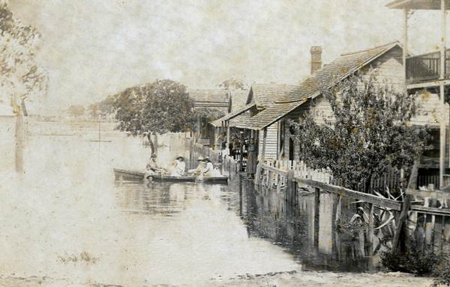
Residents of Cedar Key rowing a boat through residual floodwaters after the hurricane
Storm victims pose with damaged houses on Cedar Key
A range light on St. Simons Island toppled by the hurricane
Flash flood destruction in downtown Staunton, looking south
Cedar Key is a city in Levy County, Florida, United States. As of the 2020 census, its population was 687, down from 702 at the 2010 census. It is part of the Gainesville, Florida Metropolitan Statistical Area. The Cedar Keys are a cluster of islands near the mainland. Most of the developed area for the City of Cedar Key has been on Way Key since the end of the 19th century. The Cedar Keys are named for the eastern red cedar Juniperus virginiana, once abundant in the area.
Aerial view of Cedar Key and its outlying islands, illustrating the extremely small size of the city: The fork at State Road 24 and County Road 347 (the only two access roads) can be seen in the upper left.
Dock Street in Cedar Key
Island Hotel
Cedar Key in 1939


