West Sumatra, Dutch East Indies was struck by an earthquake doublet on June 28, 1926. The first earthquake occurred at 10:23 local time, with an estimated magnitude of 6.7 on the surface-wave magnitud

Structure in Padang Panjang toppled after the earthquake

The Jam Gadang tower in 1935

COLLECTIE TROPENMUSEUM Een verwoeste school te Padang Pandjang na de aardbeving van 1926 T Mnr 10003985
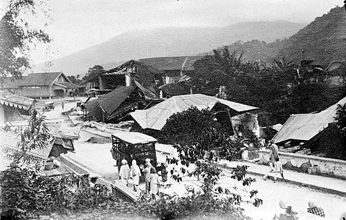
COLLECTIE TROPENMUSEUM Een overzicht van een verwoeste straat in Padang Padjang na de aardbeving van 1926 T Mnr 10003981
Padang Panjang
Videos
Padang Panjang is a city located at in the highlands of West Sumatra, around 70 km inland from the provincial capital Padang. It sits on a plateau beneath the volcanoes Mount Marapi and Mount Singgala
1926 Padang Panjang earthquakes
…1926 Padang Panjang earthquake Structure in Padang Panjang toppled after the earthquake Location within Sumatra Location within Indonesia UTC time Doublet earthquake: A: 1926-06-28 03:23:28 B: 1926-06-28 06:15:48…

A traditional Minangkabau rumah gadang ("big house") in Padang Panjang

Rectorate building of the ISI (Institut Seni Indonesia) Padang Panjang, previously it was called STSI (Sekolah Tinggi Seni Indonesia) Padang Panjang

Street scenery in Padang Panjang in colonial times, with Mount Marapi