2007 California wildfires
The 2007 California wildfire season saw at least 9,093 separate wildfires that charred 1,520,362 acres (6,152.69 km2) of land. Thirty of those wildfires were part of the Fall 2007 California firestorm, which burned approximately 972,147 acres of land from Santa Barbara County to the U.S.–Mexico border. At the peak of the wildfire activity in October 2007, the raging wildfires were visible from space.
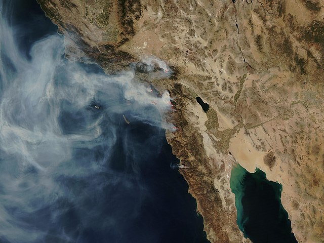
NASA satellite photo (provided by NSPO, Taiwan National Space Organization) from October 24, 2007, showing the active fire zones and smoke plumes.
QuikSCAT image from 2002 showing the speed of the Santa Ana winds (m/s)
A comparison of the Simi Valley skyline from October 21, 2007 (left and center) to October 22, 2007 (right)
Evacuees at evacuation site Mira Mesa High School
October 2007 California wildfires
The October 2007 California wildfires, also known as the Fall 2007 California firestorm, were a series of about thirty wildfires that began igniting across Southern California on October 20. At least 1,500 homes were destroyed and approximately 972,147 acres of land was burned from Santa Barbara County to the U.S.–Mexico border, surpassing the October 2003 California wildfires in scope, which were estimated to have burned 800,000 acres (3,200 km2). The wildfires killed a total of 14 people, with nine of them dying directly from the fires; 160 others were injured, including at least 124 firefighters. At their height, the raging fires were visible from space. These fires included the vast majority of the largest and deadliest wildfires of the 2007 California wildfire season. The only wildfire in 2007 that surpassed any of the individual October 2007 fires in size was the Zaca Fire.
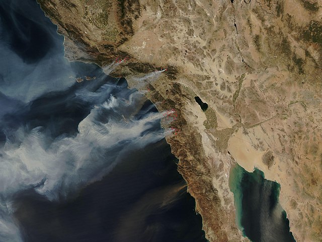
NASA satellite photo (provided by NSPO, Taiwan National Space Organization) from October 22, 2007, showing the active fire zones and smoke plumes.
Smoke filling the sky at sunrise, on October 22, 2007.
San Diego skyline against the smoke at sunrise, on October 23, 2007.
The Harris Fire burning on Mount San Miguel, on the morning of October 23, 2007