Amundsen Sea
Videos
The Amundsen Sea is an arm of the Southern Ocean off Marie Byrd Land in western Antarctica. It lies between Cape Flying Fish to the east and Cape Dart on Siple Island to the west. Cape Flying Fish marks the boundary between the Amundsen Sea and the Bellingshausen Sea. West of Cape Dart there is no named marginal sea of the Southern Ocean between the Amundsen and Ross Seas. The Norwegian expedition of 1928–1929 under Captain Nils Larsen named the body of water for the Norwegian polar explorer Roald Amundsen while exploring this area in February 1929.
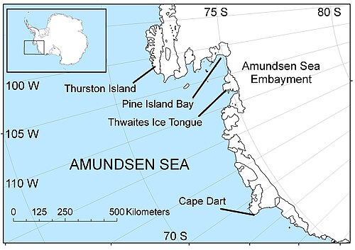
The Amundsen Sea area of Antarctica

Antarctic iceberg floating in the Amundsen Sea water, October 2009.

Large B-22 iceberg breaking off from Thwaites Glacier and remnants of the B-21 iceberg from Pine Island Glacier in Pine Island Bay to the right of the image

Diagram of a proposed "curtain".
Ice sheet
Videos
In glaciology, an ice sheet, also known as a continental glacier, is a mass of glacial ice that covers surrounding terrain and is greater than 50,000 km2 (19,000 sq mi). The only current ice sheets are the Antarctic ice sheet and the Greenland ice sheet. Ice sheets are bigger than ice shelves or alpine glaciers. Masses of ice covering less than 50,000 km2 are termed an ice cap. An ice cap will typically feed a series of glaciers around its periphery.

One of Earth's two ice sheets: The Antarctic ice sheet covers about 98% of the Antarctic continent and is the largest single mass of ice on Earth. It has an average thickness of over 2 kilometers.

Glacial flow rate in the Antarctic ice sheet.

The collapse of the Larsen B ice shelf had profound effects on the velocities of its feeder glaciers.

Accelerated ice flows after the break-up of an ice shelf