Arroyo Trabuco is a 22-mile (35 km)-long stream in coastal southern California in the United States. Rising in a rugged canyon in the Santa Ana Mountains of Orange County, the creek flows west and southwest before emptying into San Juan Creek in the city of San Juan Capistrano. Arroyo Trabuco's watershed drains 54 square miles (140 km2) of hilly, semi-arid land and lies mostly in Orange County, with a small portion extending northward into Riverside County. The lower section of the creek flows through three incorporated cities and is moderately polluted by urban and agricultural runoff.
Arroyo Trabuco shortly downstream of Interstate 5
Arroyo Trabuco crosses underneath Interstate 5 in a culvert. Note that at first, there was only one culvert. Due to increasing flood control requirements, there are now two.
An artificial concrete waterfall on Arroyo Trabuco, downstream of the Metrolink rail bridge and upstream of the Oso Creek confluence
Arroyo Trabuco filled with urban runoff after a storm
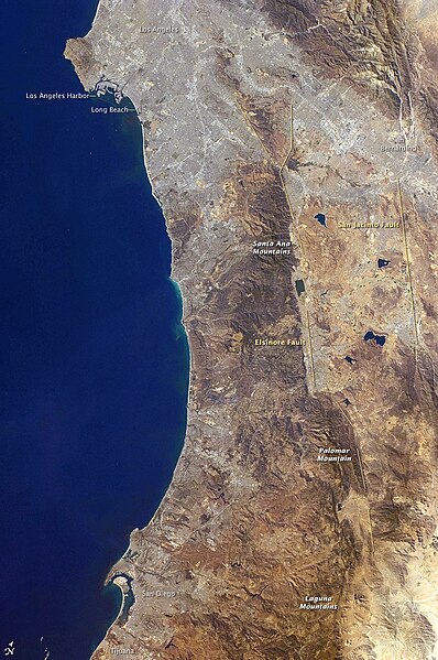
The Santa Ana Mountains are a short peninsular mountain range along the coast of Southern California in the United States. They extend for approximately 61 miles (98 km) southeast of the Los Angeles Basin largely along the border between Orange and Riverside counties.
Image: Tecate cypress imported from i Naturalist photo 131099605 on 8 March 2024
Image: Wpdms shdrlfi 020l santa ana mountains
San Mateo Canyon Wilderness, southern Santa Ana Mountains, April 2007. Note the chaparral vegetation type, typical of the range
The Santa Ana Mountains, with other Peninsular Ranges and landforms in Southern California.