South West England
South West England is one of nine official regions of England. It is the largest in area, covering 9,200 square miles, consists of the counties of Gloucestershire, Wiltshire, Dorset and Cornwall, as well as the Isles of Scilly. Five million people live in South West England; the region includes much of the ancient kingdom of Wessex. The largest city is Bristol. Other major urban centres include Plymouth, Gloucester, Exeter, Bath and the South East Dorset conurbation which includes Bournemouth and Christchurch. There are eight cities: Salisbury, Wells, Gloucester, Exeter and Truro, it includes two entire national parks and Exmoor. The northern part of Gloucestershire, near Chipping Campden, is as close to the Scottish border as it is to the tip of Cornwall; the region has by far the longest coastline of any English region. The region is at the first level of NUTS for Eurostat purposes. Key data and facts about the region are produced by the South West Observatory. Following the abolition of the South West Regional Assembly and Government Office, local government co-ordination across the region is now undertaken by South West Councils.
The region is known for its rich folklore, including the legend of King Arthur and Glastonbury Tor, as well as its traditions and customs. Cornwall has its own language and some regard it as a Celtic nation; the South West is known for Cheddar cheese. It is home to the Eden Project, Aardman Animations, the Glastonbury Festival, the Bristol International Balloon Fiesta, trip hop music and Cornwall's surfing beaches; the region has been home to some of Britain's most renowned writers, including Daphne du Maurier and Agatha Christie, both of whom set many of their works here, the South West is the location of Thomas Hardy's Wessex, the setting for many of his best-known novels. Most of the region is located on the South West Peninsula, between the English Channel and Bristol Channel, it has the longest coastline of all the English regions, totalling over 700 miles. Much of the coast is now protected from further substantial development because of its environmental importance, which contributes to the region's attractiveness to tourists and residents.
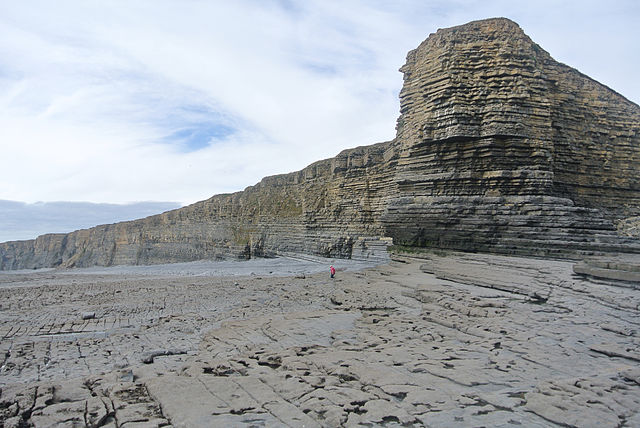
Geologically the region is divided into the igneous and metamorphic west and sedimentary east, the dividing line to the west of the River Exe. Cornwall and West Devon's landscape is of rocky coastline and high moorland, notably at Bodmin Moor and Dartmoor; these are due to the slate that underlie the area. The highest point of the region is High Willhays, at 2,038 feet, on Dartmoor. In North Devon the slates of the west and limestones of the east meet at Exmoor National Park; the variety of rocks of similar ages seen here have led to the county's name being lent to that of the Devonian period. The east of the region is characterised by limestone downland; the vales, with good irrigation, are home to the region's dairy agriculture. The Blackmore Vale was Thomas Hardy's "Vale of the Little Dairies"; the Southern England Chalk Formation extends into the region, creating a series of high, sparsely populated and archaeologically rich downs, most famously Salisbury Plain, but Cranborne Chase, the Dorset Downs and the Purbeck Hills.
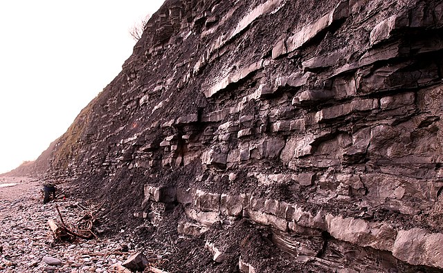
These downs are the principal area of arable agriculture in the region. Limestone is found in the region, at the Cotswolds, Quantock Hills and Mendip Hills, where they support sheep farming. All of the principal rock types can be seen on the Jurassic Coast of Dorset and East Devon, where they document the entire Mesozoic era from west to east; the climate of South West England is classed as oceanic according to the Köppen climate classification. The oceanic climate experiences cool winters with warmer summers and precipitation all year round, with more experienced in winter. Annual rainfall is up to 2,000 millimetres on higher ground. Summer maxima averages range from 18 °C to 22 °C and winter minimum averages range from 1 °C to 4 °C across the south-west, it is the second windiest area of the United Kingdom, the majority of winds coming from the south-west and north-east. Government organisations predict the region to rise in temperature and become the hottest region in the United Kingdom. Inland areas of low altitude experience the least amount of precipitation.
They experience the highest summer maxima temperatures. Snowfalls are less so in comparison to higher ground, it experiences the lowest wind speeds and sunshine total in between that of the moors. The climate of inland areas is more noticeable the further north-east into the region. In comparison to inland areas, the coast experiences high minimum temperatures in winter, it experiences lower maximum temperatures during the summer. Rainfall is the lowest at the coast and snowfall is rarer than the rest of the region. Coastal areas are the windiest parts of the peninsula and they receive the most sunshine; the general coastal climate is more typical the further south-west into the region. Areas of moorland inland such as: Bodmin Moor and Exmoor experience lower temperatures and more precipitation than the rest of the south west (approxima
Fossil
A fossil is any preserved remains, impression, or trace of any once-living thing from a past geological age. Examples include bones, exoskeletons, stone imprints of animals or microbes, objects preserved in amber, petrified wood, coal, DNA remnants; the totality of fossils is known as the fossil record. Paleontology is the study of fossils: their age, method of formation, evolutionary significance. Specimens are considered to be fossils if they are over 10,000 years old; the oldest fossils are around 3.48 billion years old to 4.1 billion years old. The observation in the 19th century that certain fossils were associated with certain rock strata led to the recognition of a geological timescale and the relative ages of different fossils; the development of radiometric dating techniques in the early 20th century allowed scientists to quantitatively measure the absolute ages of rocks and the fossils they host. There are many processes that lead to fossilization, including permineralization and molds, authigenic mineralization and recrystallization, adpression and bioimmuration.
Fossils vary in size from one-micrometre bacteria to dinosaurs and trees, many meters long and weighing many tons. A fossil preserves only a portion of the deceased organism that portion, mineralized during life, such as the bones and teeth of vertebrates, or the chitinous or calcareous exoskeletons of invertebrates. Fossils may consist of the marks left behind by the organism while it was alive, such as animal tracks or feces; these types of fossil are called trace ichnofossils, as opposed to body fossils. Some fossils are called chemofossils or biosignatures; the process of fossilization varies according to external conditions. Permineralization is a process of fossilization; the empty spaces within an organism become filled with mineral-rich groundwater. Minerals precipitate from the groundwater; this process can occur in small spaces, such as within the cell wall of a plant cell. Small scale permineralization can produce detailed fossils. For permineralization to occur, the organism must become covered by sediment soon after death, otherwise decay commences.
The degree to which the remains are decayed when covered determines the details of the fossil. Some fossils consist only of skeletal teeth; this is a form of diagenesis. In some cases, the original remains of the organism dissolve or are otherwise destroyed; the remaining organism-shaped hole in the rock is called an external mold. If this hole is filled with other minerals, it is a cast. An endocast, or internal mold, is formed when sediments or minerals fill the internal cavity of an organism, such as the inside of a bivalve or snail or the hollow of a skull; this is a special form of mold formation. If the chemistry is right, the organism can act as a nucleus for the precipitation of minerals such as siderite, resulting in a nodule forming around it. If this happens before significant decay to the organic tissue fine three-dimensional morphological detail can be preserved. Nodules from the Carboniferous Mazon Creek fossil beds of Illinois, USA, are among the best documented examples of such mineralization.
Replacement occurs. In some cases mineral replacement of the original shell occurs so and at such fine scales that microstructural features are preserved despite the total loss of original material. A shell is said to be recrystallized when the original skeletal compounds are still present but in a different crystal form, as from aragonite to calcite. Compression fossils, such as those of fossil ferns, are the result of chemical reduction of the complex organic molecules composing the organism's tissues. In this case the fossil consists of original material, albeit in a geochemically altered state; this chemical change is an expression of diagenesis. What remains is a carbonaceous film known as a phytoleim, in which case the fossil is known as a compression. However, the phytoleim is lost and all that remains is an impression of the organism in the rock—an impression fossil. In many cases, however and impressions occur together. For instance, when the rock is broken open, the phytoleim will be attached to one part, whereas the counterpart will just be an impression.
For this reason, one term covers the two modes of preservation: adpression. Because of their antiquity, an unexpected exception to the alteration of an organism's tissues by chemical reduction of the complex organic molecules during fossilization has been the discovery of soft tissue in dinosaur fossils, including blood vessels, the isolation of proteins and evidence for DNA fragments. In 2014, Mary Schweitzer and her colleagues reported the presence of iron particles associated with soft tissues recovered from dinosaur fossils. Based on various experiments that studied the interaction of iron in haemoglobin with blood vessel tissue they proposed that solution hypoxia coupled with iron chelation enhances the stability and preservation of soft tissue and provides the basis for an explanation for the unforeseen preservation of fossil soft tissues. However, a older study based on eight taxa ranging in time from the Devonian to the Jurassic found that reasonably well-preserved fibrils that represent collagen were preser
Europe
Europe is a continent located in the Northern Hemisphere and in the Eastern Hemisphere. It is bordered by the Arctic Ocean to the north, the Atlantic Ocean to the west and the Mediterranean Sea to the south, it comprises the westernmost part of Eurasia. Since around 1850, Europe is most considered to be separated from Asia by the watershed divides of the Ural and Caucasus Mountains, the Ural River, the Caspian and Black Seas and the waterways of the Turkish Straits. Although the term "continent" implies physical geography, the land border is somewhat arbitrary and has been redefined several times since its first conception in classical antiquity; the division of Eurasia into two continents reflects East-West cultural and ethnic differences which vary on a spectrum rather than with a sharp dividing line. The geographic border does not follow political boundaries, with Turkey and Kazakhstan being transcontinental countries. A strict application of the Caucasus Mountains boundary places two comparatively small countries and Georgia, in both continents.
Europe covers 2 % of the Earth's surface. Politically, Europe is divided into about fifty sovereign states of which the Russian Federation is the largest and most populous, spanning 39% of the continent and comprising 15% of its population. Europe had a total population of about 741 million as of 2016; the European climate is affected by warm Atlantic currents that temper winters and summers on much of the continent at latitudes along which the climate in Asia and North America is severe. Further from the sea, seasonal differences are more noticeable than close to the coast. Europe, in particular ancient Greece, was the birthplace of Western civilization; the fall of the Western Roman Empire in 476 AD and the subsequent Migration Period marked the end of ancient history and the beginning of the Middle Ages. Renaissance humanism, exploration and science led to the modern era. Since the Age of Discovery started by Portugal and Spain, Europe played a predominant role in global affairs. Between the 16th and 20th centuries, European powers controlled at various times the Americas all of Africa and Oceania and the majority of Asia.
The Age of Enlightenment, the subsequent French Revolution and the Napoleonic Wars shaped the continent culturally and economically from the end of the 17th century until the first half of the 19th century. The Industrial Revolution, which began in Great Britain at the end of the 18th century, gave rise to radical economic and social change in Western Europe and the wider world. Both world wars took place for the most part in Europe, contributing to a decline in Western European dominance in world affairs by the mid-20th century as the Soviet Union and the United States took prominence. During the Cold War, Europe was divided along the Iron Curtain between NATO in the West and the Warsaw Pact in the East, until the revolutions of 1989 and fall of the Berlin Wall. In 1949 the Council of Europe was founded, following a speech by Sir Winston Churchill, with the idea of unifying Europe to achieve common goals, it includes all European states except for Belarus and Vatican City. Further European integration by some states led to the formation of the European Union, a separate political entity that lies between a confederation and a federation.
The EU originated in Western Europe but has been expanding eastward since the fall of the Soviet Union in 1991. The currency of most countries of the European Union, the euro, is the most used among Europeans. In classical Greek mythology, Europa was a Phoenician princess; the word Europe is derived from her name. The name contains the elements εὐρύς, "wide, broad" and ὤψ "eye, countenance", hence their composite Eurṓpē would mean "wide-gazing" or "broad of aspect". Broad has been an epithet of Earth herself in the reconstructed Proto-Indo-European religion and the poetry devoted to it. There have been attempts to connect Eurṓpē to a Semitic term for "west", this being either Akkadian erebu meaning "to go down, set" or Phoenician'ereb "evening, west", at the origin of Arabic Maghreb and Hebrew ma'arav. Michael A. Barry, professor in Princeton University's Near Eastern Studies Department, finds the mention of the word Ereb on an Assyrian stele with the meaning of "night, sunset", in opposition to Asu " sunrise", i.e. Asia.
The same naming motive according to "cartographic convention" appears in Greek Ἀνατολή. Martin Litchfield West stated that "phonologically, the match between Europa's name and any form of the Semitic word is poor." Next to these hypotheses there is a Proto-Indo-European root *h1regʷos, meaning "darkness", which produced Greek Erebus. Most major world languages use words derived from Europa to refer to the continent. Chinese, for example, uses the word Ōuzhōu. In some Turkic languages the Persian name Frangistan is used casually in referring to much of Europe, besides official names such as Avrupa or Evropa; the prevalent definition of Europe as a geographical term has been in use since the mid-19th century. Europe is taken to be bounded by large bodies of water
Cambrian
The Cambrian Period was the first geological period of the Paleozoic Era, of the Phanerozoic Eon. The Cambrian lasted 55.6 million years from the end of the preceding Ediacaran Period 541 million years ago to the beginning of the Ordovician Period 485.4 mya. Its subdivisions, its base, are somewhat in flux; the period was established by Adam Sedgwick, who named it after Cambria, the Latin name of Wales, where Britain's Cambrian rocks are best exposed. The Cambrian is unique in its unusually high proportion of lagerstätte sedimentary deposits, sites of exceptional preservation where "soft" parts of organisms are preserved as well as their more resistant shells; as a result, our understanding of the Cambrian biology surpasses that of some periods. The Cambrian marked a profound change in life on Earth. Complex, multicellular organisms became more common in the millions of years preceding the Cambrian, but it was not until this period that mineralized—hence fossilized—organisms became common; the rapid diversification of life forms in the Cambrian, known as the Cambrian explosion, produced the first representatives of all modern animal phyla.
Phylogenetic analysis has supported the view that during the Cambrian radiation, metazoa evolved monophyletically from a single common ancestor: flagellated colonial protists similar to modern choanoflagellates. Although diverse life forms prospered in the oceans, the land is thought to have been comparatively barren—with nothing more complex than a microbial soil crust and a few molluscs that emerged to browse on the microbial biofilm. Most of the continents were dry and rocky due to a lack of vegetation. Shallow seas flanked the margins of several continents created during the breakup of the supercontinent Pannotia; the seas were warm, polar ice was absent for much of the period. Despite the long recognition of its distinction from younger Ordovician rocks and older Precambrian rocks, it was not until 1994 that the Cambrian system/period was internationally ratified; the base of the Cambrian lies atop a complex assemblage of trace fossils known as the Treptichnus pedum assemblage. The use of Treptichnus pedum, a reference ichnofossil to mark the lower boundary of the Cambrian, is difficult since the occurrence of similar trace fossils belonging to the Treptichnids group are found well below the T. pedum in Namibia and Newfoundland, in the western USA.
The stratigraphic range of T. pedum overlaps the range of the Ediacaran fossils in Namibia, in Spain. The Cambrian Period was followed by the Ordovician Period; the Cambrian is divided into ten ages. Only three series and six stages are named and have a GSSP; because the international stratigraphic subdivision is not yet complete, many local subdivisions are still used. In some of these subdivisions the Cambrian is divided into three series with locally differing names – the Early Cambrian, Middle Cambrian and Furongian. Rocks of these epochs are referred to as belonging to Upper Cambrian. Trilobite zones allow biostratigraphic correlation in the Cambrian; each of the local series is divided into several stages. The Cambrian is divided into several regional faunal stages of which the Russian-Kazakhian system is most used in international parlance: *Most Russian paleontologists define the lower boundary of the Cambrian at the base of the Tommotian Stage, characterized by diversification and global distribution of organisms with mineral skeletons and the appearance of the first Archaeocyath bioherms.
The International Commission on Stratigraphy list the Cambrian period as beginning at 541 million years ago and ending at 485.4 million years ago. The lower boundary of the Cambrian was held to represent the first appearance of complex life, represented by trilobites; the recognition of small shelly fossils before the first trilobites, Ediacara biota earlier, led to calls for a more defined base to the Cambrian period. After decades of careful consideration, a continuous sedimentary sequence at Fortune Head, Newfoundland was settled upon as a formal base of the Cambrian period, to be correlated worldwide by the earliest appearance of Treptichnus pedum. Discovery of this fossil a few metres below the GSSP led to the refinement of this statement, it is the T. pedum ichnofossil assemblage, now formally used to correlate the base of the Cambrian. This formal designation allowed radiometric dates to be obtained from samples across the globe that corresponded to the base of the Cambrian. Early dates of 570 million years ago gained favour, though the methods used to obtain this number are now considered to be unsuitable and inaccurate.
A more precise date using modern radiometric dating yield a date of 541 ± 0.3 million years ago. The ash horizon in Oman from which this date was recovered corresponds to a marked fall in the abundance of carbon-13 that correlates to equivalent excursions elsewhere in the world, to the disappearance of distinctive Ediacaran fossils. There are arguments that the dated horizon in Oman does not correspond to the Ediacaran-Cambrian boundary, but represents a facies change from marine to evaporite-dominated strata — which w
Silurian
The Silurian is a geologic period and system spanning 24.6 million years from the end of the Ordovician Period, at 443.8 million years ago, to the beginning of the Devonian Period, 419.2 Mya. The Silurian is the shortest period of the Paleozoic Era; as with other geologic periods, the rock beds that define the period's start and end are well identified, but the exact dates are uncertain by several million years. The base of the Silurian is set at a series of major Ordovician–Silurian extinction events when 60% of marine species were wiped out. A significant evolutionary milestone during the Silurian was the diversification of jawed fish and bony fish. Multi-cellular life began to appear on land in the form of small, bryophyte-like and vascular plants that grew beside lakes and coastlines, terrestrial arthropods are first found on land during the Silurian. However, terrestrial life would not diversify and affect the landscape until the Devonian; the Silurian system was first identified by British geologist Roderick Murchison, examining fossil-bearing sedimentary rock strata in south Wales in the early 1830s.
He named the sequences for a Celtic tribe of Wales, the Silures, inspired by his friend Adam Sedgwick, who had named the period of his study the Cambrian, from the Latin name for Wales. This naming does not indicate any correlation between the occurrence of the Silurian rocks and the land inhabited by the Silures. In 1835 the two men presented a joint paper, under the title On the Silurian and Cambrian Systems, Exhibiting the Order in which the Older Sedimentary Strata Succeed each other in England and Wales, the germ of the modern geological time scale; as it was first identified, the "Silurian" series when traced farther afield came to overlap Sedgwick's "Cambrian" sequence, provoking furious disagreements that ended the friendship. Charles Lapworth resolved the conflict by defining a new Ordovician system including the contested beds. An early alternative name for the Silurian was "Gotlandian" after the strata of the Baltic island of Gotland; the French geologist Joachim Barrande, building on Murchison's work, used the term Silurian in a more comprehensive sense than was justified by subsequent knowledge.
He divided the Silurian rocks of Bohemia into eight stages. His interpretation was questioned in 1854 by Edward Forbes, the stages of Barrande, F, G and H, have since been shown to be Devonian. Despite these modifications in the original groupings of the strata, it is recognized that Barrande established Bohemia as a classic ground for the study of the earliest fossils; the Llandovery Epoch lasted from 443.8 ± 1.5 to 433.4 ± 2.8 mya, is subdivided into three stages: the Rhuddanian, lasting until 440.8 million years ago, the Aeronian, lasting to 438.5 million years ago, the Telychian. The epoch is named for the town of Llandovery in Wales; the Wenlock, which lasted from 433.4 ± 1.5 to 427.4 ± 2.8 mya, is subdivided into the Sheinwoodian and Homerian ages. It is named after Wenlock Edge in England. During the Wenlock, the oldest-known tracheophytes of the genus Cooksonia, appear; the complexity of later Gondwana plants like Baragwanathia, which resembled a modern clubmoss, indicates a much longer history for vascular plants, extending into the early Silurian or Ordovician.
The first terrestrial animals appear in the Wenlock, represented by air-breathing millipedes from Scotland. The Ludlow, lasting from 427.4 ± 1.5 to 423 ± 2.8 mya, comprises the Gorstian stage, lasting until 425.6 million years ago, the Ludfordian stage. It is named for the town of Ludlow in England; the Přídolí, lasting from 423 ± 1.5 to 419.2 ± 2.8 mya, is the final and shortest epoch of the Silurian. It is named after one locality at the Homolka a Přídolí nature reserve near the Prague suburb Slivenec in the Czech Republic. Přídolí is the old name of a cadastral field area. In North America a different suite of regional stages is sometimes used: Cayugan Lockportian Tonawandan Ontarian Alexandrian In Estonia the following suite of regional stages is used: Ohessaare stage Kaugatuma stage Kuressaare stage Paadla stage Rootsiküla stage Jaagarahu stage Jaani stage Adavere stage Raikküla stage Juuru stage With the supercontinent Gondwana covering the equator and much of the southern hemisphere, a large ocean occupied most of the northern half of the globe.
The high sea levels of the Silurian and the flat land resulted in a number of island chains, thus a rich diversity of environmental settings. During the Silurian, Gondwana continued a slow southward drift to high southern latitudes, but there is evidence that the Silurian icecaps were less extensive than those of the late-Ordovician glaciation; the southern continents remained united during this period. The melting of icecaps and glaciers contributed to a rise in sea level, recognizable from the fact that Silurian sediments overlie eroded Ordovician sediments, forming an unconformity; the continents of Avalonia and Laurentia drifted together near the equator, starting the formation of a second supercontinent known as Euramerica. When the proto-Europe coll