Bristol Harbour
Videos
Bristol Harbour is the harbour in the city of Bristol, England. The harbour covers an area of 70 acres. It is the former natural tidal river Avon through the city but was made into its current form in 1809 when the tide was prevented from going out permanently. A tidal by-pass was dug for 2 miles through the fields of Bedminster for the river, known as the "River Avon New Cut", "New Cut", or simply "The Cut". It is often called the Floating Harbour as the water level remains constant and it is not affected by the state of the tide on the river in the Avon Gorge, The New Cut or the natural river southeast of Temple Meads to its source.

Bristol Harbour, looking toward the city centre

Black and white etching showing the towers of St Stephen's Church, St Augustine the Less Church and Bristol Cathedral, published c. 1850. The view shows the historic harbour with ten sailing ships and rowing boats before the channel was filled in 1892–1938.

A tall ship in the Cumberland lock, Hotwells, during the 2004 Harbour Festival

The Cumberland Basin
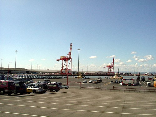
Royal Portbury Dock
Videos
The Royal Portbury Dock is part of the Port of Bristol, in England. It is situated near the village of Portbury on the southern side of the mouth of the Avon, where the river joins the Severn estuary — the Avonmouth Docks are on the opposite side of the Avon, within Avonmouth. The deepwater dock was constructed between 1972 and 1977, and is now a major port for the import of motor vehicles into the UK. The M5 motorway runs nearby, and the huge car storage compounds around the dock are visible from the Avonmouth Bridge. A waste industrial area west of the port is being developed as the Portbury Ashlands Nature Reserve.
Royal Portbury Dock, looking out to the Severn estuary

Container ship unloading