California State Route 1
Videos
State Route 1 (SR 1) is a major north–south state highway that runs along most of the Pacific coastline of the U.S. state of California. At 656 miles (1,056 km), it is the longest state route in California, and the second-longest in the US after Montana Highway 200. SR 1 has several portions designated as either Pacific Coast Highway (PCH), Cabrillo Highway, Shoreline Highway, or Coast Highway. Its southern terminus is at Interstate 5 (I-5) near Dana Point in Orange County and its northern terminus is at U.S. Route 101 (US 101) near Leggett in Mendocino County. SR 1 also at times runs concurrently with US 101, most notably through a 54-mile (87 km) stretch in Ventura and Santa Barbara counties, and across the Golden Gate Bridge.

Southbound PCH in Crystal Cove State Park near Laguna Beach

The Pacific Corporate Towers alongside PCH in El Segundo, California

Southbound SR 1 near the intersection of Lincoln and Sepulveda Boulevards north of LAX

PCH passing Mugu Rock at Point Mugu
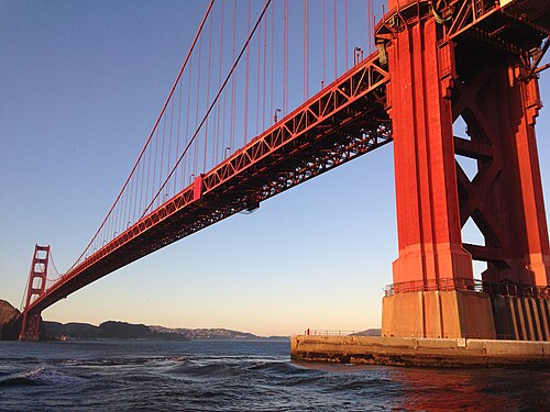
Golden Gate Bridge
Videos
The Golden Gate Bridge is a suspension bridge spanning the Golden Gate, the one-mile-wide (1.6 km) strait connecting San Francisco Bay and the Pacific Ocean. The structure links the U.S. city of San Francisco, California—the northern tip of the San Francisco Peninsula—to Marin County, carrying both U.S. Route 101 and California State Route 1 across the strait. It also carries pedestrian and bicycle traffic, and is designated as part of U.S. Bicycle Route 95. Recognized by the American Society of Civil Engineers as one of the Wonders of the Modern World, the bridge is one of the most internationally recognized symbols of San Francisco and California.

View from the Presidio of San Francisco, 2017

South tower seen from walkway, with Art Deco elements
Below Golden Gate Bridge

Panorama of the Golden Gate Bridge at sunset, as seen from just north of Alcatraz Island