The Changtang is a part of the high altitude Tibetan Plateau in western and northern Tibet extending into the southern edges of Xinjiang as well as southeastern Ladakh, India, with vast highlands and giant lakes. From eastern Ladakh, the Changtang stretches approximately 1,600 kilometres (990 mi) east into Tibet as far as modern Qinghai. The Changtang is home to the Changpa, a nomadic Tibetan people. The two largest settlements within the Tibetan Changtang are Rutog Town the seat of Rutog County and Domar Township the seat of Shuanghu County.
Changpa nomadic people in Tibet
Nomad mother and son. Changtang, Ladakh
The Tibetan Plateau, also known as Qinghai–Tibet Plateau and Qing–Zang Plateau, is a vast elevated plateau located at the intersection of Central, South, and East Asia covering most of the Tibet Autonomous Region, most of Qinghai, western half of Sichuan, Southern Gansu provinces in Western China, southern Xinjiang, Bhutan, the Indian regions of Ladakh and Lahaul and Spiti as well as Gilgit-Baltistan in Pakistan, northwestern Nepal, eastern Tajikistan and southern Kyrgyzstan. It stretches approximately 1,000 kilometres (620 mi) north to south and 2,500 kilometres (1,600 mi) east to west. It is the world's highest and largest plateau above sea level, with an area of 2,500,000 square kilometres (970,000 sq mi). With an average elevation exceeding 4,500 metres (14,800 ft) and being surrounded by imposing mountain ranges that harbor the world's two highest summits, Mount Everest and K2, the Tibetan Plateau is often referred to as "the Roof of the World".
The Tibetan Plateau lies between the Himalayan range to the south and the Taklamakan Desert to the north. (Composite image)
Yamdrok Lake is one of the four largest lakes in Tibet. All four lakes are considered sacred pilgrimage sites in the local tradition.
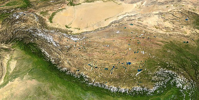
Natural-colour satellite image of the Tibetan Plateau.
Yangbajain valley to the north of Lhasa


