Chesil Cove is a curved steep bank forming the south-east end of 29-kilometre (18 mi) Chesil Beach in Dorset, England. It is thus part of one of three large shingle structures in Britain, extending from West Bay to the Isle of Portland, the latter acting more firmly as a great barrier (groyne) which stops tidal action from washing the beach away and leads to the high depositions by wind and tide action forming the grand curved bank of this "cove". The "cove", bill and much of Chesil Beach give shelter from the prevailing winds and waves for much of Weymouth Bay, the town of Weymouth and the village of Chiswell. It forms part of the Jurassic Coast.
Chesil Cove at Chiswell on the Isle of Portland.
The high beach of Chesil Cove from Isle of Portland, showing Weymouth Bay across the isthmus
Chesil Beach in Dorset, England is one of three major shingle beach structures in Britain. Its name is derived from the Old English ceosel or cisel, meaning "gravel" or "shingle". It runs for a length of 29 kilometres (18 mi) from West Bay to the Isle of Portland and in places is up to 15 metres (50 ft) high and 200 metres (660 ft) wide. Behind the beach is the Fleet, a shallow tidal lagoon. Both are part of the Jurassic Coast and a UNESCO World Heritage Site, and together form an SSSI and Ramsar Site.
Chesil Beach viewed from the Isle of Portland
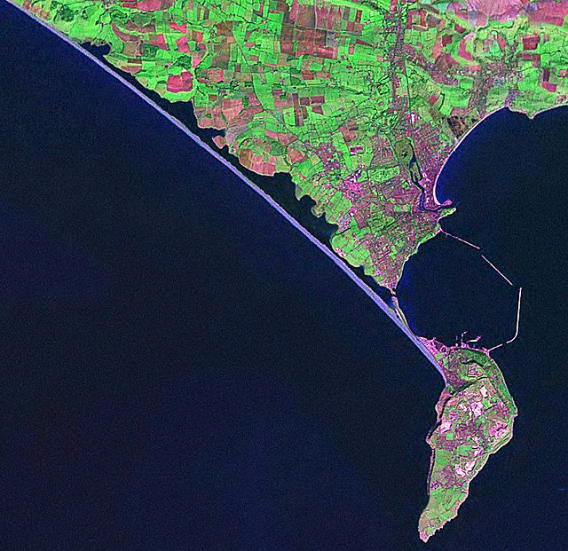
Satellite view of Chesil Beach (linear feature in blue running diagonally NW-SE) from Abbotsbury to the Isle of Portland
Chesil Cove at the Portland end of Chesil Beach
Highball bouncing bomb prototype, now on display at Abbotsbury Swannery