1.
International Union for Conservation of Nature
–
The International Union for Conservation of Nature is an international organization working in the field of nature conservation and sustainable use of natural resources. It is involved in gathering and analysis, research, field projects, advocacy, lobbying. IUCNs mission is to influence, encourage and assist societies throughout the world to conserve nature and to ensure that any use of resources is equitable. Over the past decades, IUCN has widened its focus beyond conservation ecology and now incorporates issues related to equality, poverty alleviation. Unlike other international NGOs, IUCN does not itself aim to mobilize the public in support of nature conservation and it tries to influence the actions of governments, business and other stakeholders by providing information and advice, and through lobbying and partnerships. The organization is best known to the public for compiling and publishing the IUCN Red List. IUCN has a membership of over 1200 governmental and non-governmental organizations, some 11,000 scientists and experts participate in the work of IUCN commissions on a voluntary basis. It employs approximately 1000 full-time staff in more than 60 countries and its headquarters are in Gland, Switzerland. IUCN has observer and consultative status at the United Nations, and plays a role in the implementation of several conventions on nature conservation. It was involved in establishing the World Wide Fund for Nature, in the past, IUCN has been criticized for placing the interests of nature over those of indigenous peoples. In recent years, its relations with the business sector have caused controversy. It was previously called the International Union for Protection of Nature, establishment In 1947, the Swiss League for the Protection of Nature organised an international conference on the protection of nature in Brunnen. It is considered to be the first government-organized non-governmental organization, the initiative to set up the new organisation came from UNESCO and especially from its first Director General, the British biologist Julian Huxley. At the time of its founding IUPN was the international organisation focusing on the entire spectrum of nature conservation Early years. Its secretariat was located in Brussels and its first work program focused on saving species and habitats, increasing and applying knowledge, advancing education, promoting international agreements and promoting conservation. Providing a solid base for conservation action was the heart of all activities. IUPN and UNESCO were closely associated and they jointly organized the 1949 Conference on Protection of Nature. In preparation for this conference a list of endangered species was drawn up for the first time
2.
Natural monument
–
A natural monument is a natural or natural/cultural feature of outstanding or unique value because of its inherent rarity, representative of aesthetic qualities or cultural significance. They are generally quite small protected areas and often have high visitor value and this is a lower level of protection than level II and level I. The European Environment Agencys guidelines for selection of a natural monument are, the area should be large enough to protect the integrity of the feature and its immediately related surroundings
3.
Morrill County, Nebraska
–
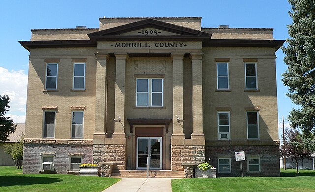
Morrill County is a county located in the U. S. state of Nebraska. As of the 2010 census, the population was 5,042, in the Nebraska license plate system, Morrill County is represented by the prefix 64. The Battle of Mud Springs and the Battle of Rush Creek between the U. S. army and the Cheyenne, Lakota Sioux, and Arapaho Indians took place in 1865 within what would become Morrill county, Morrill County was formed in 1908 carved out of Cheyenne County. It was named after Charles Henry Morrill, a president of the Lincoln Land Company. According to the U. S. Census Bureau, the county has an area of 1,430 square miles. The population density was 4 people per square mile, there were 2,460 housing units at an average density of 2 per square mile. The racial makeup of the county was 93. 68% White,0. 07% Black or African American,0. 72% Native American,0. 22% Asian,4. 12% from other races,10. 09% of the population were Hispanic or Latino of any race. 40. 5% were of German,9. 2% English,7. 3% Irish and 6. 7% American ancestry according to Census 2000. 26. 90% of all households were made up of individuals and 13. 00% had someone living alone who was 65 years of age or older, the average household size was 2.49 and the average family size was 3.03. In the county, the population was out with 27. 20% under the age of 18,7. 20% from 18 to 24,24. 40% from 25 to 44,24. 20% from 45 to 64. The median age was 40 years, for every 100 females there were 97.90 males. For every 100 females age 18 and over, there were 95.60 males, the median income for a household in the county was $30,235, and the median income for a family was $36,673. Males had an income of $27,107 versus $19,271 for females. The per capita income for the county was $14,725, about 10. 00% of families and 14. 70% of the population were below the poverty line, including 20. 00% of those under age 18 and 10. 30% of those age 65 or over. National Register of Historic Places listings in Morrill County, Nebraska Morrill County Sheriffs Office
4.
United States
–
Forty-eight of the fifty states and the federal district are contiguous and located in North America between Canada and Mexico. The state of Alaska is in the northwest corner of North America, bordered by Canada to the east, the state of Hawaii is an archipelago in the mid-Pacific Ocean. The U. S. territories are scattered about the Pacific Ocean, the geography, climate and wildlife of the country are extremely diverse. At 3.8 million square miles and with over 324 million people, the United States is the worlds third- or fourth-largest country by area, third-largest by land area. It is one of the worlds most ethnically diverse and multicultural nations, paleo-Indians migrated from Asia to the North American mainland at least 15,000 years ago. European colonization began in the 16th century, the United States emerged from 13 British colonies along the East Coast. Numerous disputes between Great Britain and the following the Seven Years War led to the American Revolution. On July 4,1776, during the course of the American Revolutionary War, the war ended in 1783 with recognition of the independence of the United States by Great Britain, representing the first successful war of independence against a European power. The current constitution was adopted in 1788, after the Articles of Confederation, the first ten amendments, collectively named the Bill of Rights, were ratified in 1791 and designed to guarantee many fundamental civil liberties. During the second half of the 19th century, the American Civil War led to the end of slavery in the country. By the end of century, the United States extended into the Pacific Ocean. The Spanish–American War and World War I confirmed the status as a global military power. The end of the Cold War and the dissolution of the Soviet Union in 1991 left the United States as the sole superpower. The U. S. is a member of the United Nations, World Bank, International Monetary Fund, Organization of American States. The United States is a developed country, with the worlds largest economy by nominal GDP. It ranks highly in several measures of performance, including average wage, human development, per capita GDP. While the U. S. economy is considered post-industrial, characterized by the dominance of services and knowledge economy, the United States is a prominent political and cultural force internationally, and a leader in scientific research and technological innovations. In 1507, the German cartographer Martin Waldseemüller produced a map on which he named the lands of the Western Hemisphere America after the Italian explorer and cartographer Amerigo Vespucci
5.
Bayard, Nebraska
–
Bayard is a city in Morrill County, Nebraska, United States. The population was 1,209 at the 2010 census, old Bayard was founded in the 1880s. It was named after the city of Bayard, Iowa, the first post office at Bayard was established in 1888. The town of Bayard was picked up and moved to its present site in 1900 in order to be on the new Union Pacific Railroad line, Bayard is located at 41°45′29″N 103°19′29″W. According to the United States Census Bureau, the city has an area of 0.70 square miles. As of the census of 2010, there were 1,209 people,484 households, the population density was 1,727.1 inhabitants per square mile. There were 557 housing units at a density of 795.7 per square mile. The racial makeup of the city was 90. 3% White,0. 2% African American,1. 1% Native American,0. 3% Asian,5. 7% from other races, hispanic or Latino of any race were 16. 8% of the population. 31. 4% of all households were made up of individuals and 16. 1% had someone living alone who was 65 years of age or older, the average household size was 2.40 and the average family size was 3.03. The median age in the city was 40.3 years. 25. 9% of residents were under the age of 18,6. 3% were between the ages of 18 and 24,23. 6% were from 25 to 44,24. 6% were from 45 to 64, and 19. 7% were 65 years of age or older. The gender makeup of the city was 49. 5% male and 50. 5% female, as of the census of 2000, there were 1,247 people,497 households, and 329 families residing in the city. The population density was 1,788.0 people per square mile, there were 572 housing units at an average density of 820.2 per square mile. The racial makeup of the city was 90. 86% White,0. 08% African American,0. 88% Native American,0. 16% Asian,6. 74% from other races, hispanic or Latino of any race were 15. 88% of the population. 31. 2% of all households were made up of individuals and 18. 9% had someone living alone who was 65 years of age or older, the average household size was 2.41 and the average family size was 2.99. In the city, the population was out with 26. 2% under the age of 18,8. 0% from 18 to 24,22. 4% from 25 to 44,23. 0% from 45 to 64. The median age was 40 years, for every 100 females there were 91.6 males. For every 100 females age 18 and over, there were 85.1 males, as of 2000 the median income for a household in the city was $30,500, and the median income for a family was $39,559
6.
Geographic coordinate system
–
A geographic coordinate system is a coordinate system used in geography that enables every location on Earth to be specified by a set of numbers, letters or symbols. The coordinates are chosen such that one of the numbers represents a vertical position. A common choice of coordinates is latitude, longitude and elevation, to specify a location on a two-dimensional map requires a map projection. The invention of a coordinate system is generally credited to Eratosthenes of Cyrene. Ptolemy credited him with the adoption of longitude and latitude. Ptolemys 2nd-century Geography used the prime meridian but measured latitude from the equator instead. Mathematical cartography resumed in Europe following Maximus Planudes recovery of Ptolemys text a little before 1300, in 1884, the United States hosted the International Meridian Conference, attended by representatives from twenty-five nations. Twenty-two of them agreed to adopt the longitude of the Royal Observatory in Greenwich, the Dominican Republic voted against the motion, while France and Brazil abstained. France adopted Greenwich Mean Time in place of local determinations by the Paris Observatory in 1911, the latitude of a point on Earths surface is the angle between the equatorial plane and the straight line that passes through that point and through the center of the Earth. Lines joining points of the same latitude trace circles on the surface of Earth called parallels, as they are parallel to the equator, the north pole is 90° N, the south pole is 90° S. The 0° parallel of latitude is designated the equator, the plane of all geographic coordinate systems. The equator divides the globe into Northern and Southern Hemispheres, the longitude of a point on Earths surface is the angle east or west of a reference meridian to another meridian that passes through that point. All meridians are halves of great ellipses, which converge at the north and south poles, the prime meridian determines the proper Eastern and Western Hemispheres, although maps often divide these hemispheres further west in order to keep the Old World on a single side. The antipodal meridian of Greenwich is both 180°W and 180°E, the combination of these two components specifies the position of any location on the surface of Earth, without consideration of altitude or depth. The grid formed by lines of latitude and longitude is known as a graticule, the origin/zero point of this system is located in the Gulf of Guinea about 625 km south of Tema, Ghana. To completely specify a location of a feature on, in, or above Earth. Earth is not a sphere, but a shape approximating a biaxial ellipsoid. It is nearly spherical, but has an equatorial bulge making the radius at the equator about 0. 3% larger than the radius measured through the poles, the shorter axis approximately coincides with the axis of rotation
7.
Nebraska
–
Nebraska /nᵻˈbræskə/ is a state that lies in both the Great Plains and the Midwestern United States. Its area is just over 77,220 sq mi with almost 1.9 million people and its largest city is Omaha, which is on the Missouri River. The state is crossed by many trails and was explored by the Lewis. Nebraska was admitted as the 37th state of the United States in 1867 and it is the only state in the United States whose legislature is unicameral and officially nonpartisan. Nebraska is composed of two major regions, the Dissected Till Plains and the Great Plains. The Dissected Till Plains is a region of rolling hills. The Great Plains occupy most of western Nebraska, characterized by treeless prairie, the state has a large agriculture sector and is a major producer of beef, pork, corn, and soybeans. Two major climatic zones are represented in Nebraska, the half of the state has a humid continental climate, and the western half. Indigenous peoples lived in the region of present-day Nebraska for thousands of years before European exploration. The historic tribes in the state included the Omaha, Missouria, Ponca, Pawnee, Otoe, when European exploration, trade, and settlement began, both Spain and France sought to control the region. In the 1690s, Spain established trade connections with the Apaches, by 1703, France had developed a regular trade with the native peoples along the Missouri River in Nebraska, and by 1719 had signed treaties with several of these peoples. After war broke out between the two countries, Spain dispatched an expedition to Nebraska under Lieutenant General Pedro de Villasur in 1720. The party was attacked and destroyed near present-day Columbus by a force of Pawnees and Otoes. The massacre of the Villasur expedition effectively put an end to Spanish exploration of Nebraska for the remainder of the 18th century, in 1762, during the Seven Years War, France ceded the Louisiana territory to Spain. Frances withdrawal from the area left Britain and Spain competing for dominance along the Mississippi, by 1773, later that year, Mackays party built a trading post, dubbed Fort Carlos IV, near present-day Homer. In 1819, the United States established Fort Atkinson as the first U. S. Army post west of the Missouri River, the army abandoned the fort in 1827 as migration moved further west. European-American settlement did not begin in any numbers until after 1848, on May 30,1854, the US Congress created the Kansas and the Nebraska territories, divided by the Parallel 40° North, under the Kansas–Nebraska Act. The Nebraska Territory included parts of the current states of Colorado, North Dakota, South Dakota, Wyoming, the territorial capital of Nebraska was Omaha
8.
North Platte River
–
The North Platte River is a major tributary of the Platte River and is approximately 716 miles long counting its many curves. It travels about 550 miles distance and its course lies in the U. S. states of Colorado, Wyoming, and Nebraska. The rugged Rocky Mountains surrounding Jackson County have at least twelve peaks over 11,000 feet in height, from Jackson County the river flows north about 200 miles out of the Routt National Forest and North Park near what is now Walden, Colorado to Casper, Wyoming. Shortly after passing Casper the river turns to the east-southeast and flows about 350 miles to the city of North Platte, the North Platte and South Platte River join to form the Platte River in western Nebraska near the city of North Platte, Nebraska. The Platte River flows to the Missouri River which joins the Mississippi River to flow to the Gulf of Mexico, the river provides the major avenue of drainage for northern Colorado, eastern Wyoming and western Nebraska. It is only navigable over most of its length at high water by canoes, kayaks, the North Platte River drainage has been an important westward route in the westward expansion of the United States. To get the two essentials, water and grass for the animals the emigration trails nearly always followed river valleys across the North American continent. These trails extended from the Missouri River, Platte River and North Platte River across Nebraska and parts of Wyoming and on to its confluence with the Sweetwater River. About 50 miles beyond what is now Casper, Wyoming the main emigration trails left the North Platte valley and followed the Sweetwater River valley, the lack of American trappers and settlers in the contested Oregon Territory resulted in this early discovery being unused and nearly forgotten. Mule trains carrying in trading supplies for the men and fur trappers were some of the first to use the trail in 1824. The fur traders on their return trip carried the traded furs back east at the end of the trading season. This fur trade continued to be used to about 1840. Following the fur traders, the emigration trails established along the north and south banks of the North Platte River were the Oregon, California, Mormon. The trails north of the North Platte River originally crossed the North Platte near Fort Laramie to join the original Oregon, in 1850 Childs Route extended the north side trail to what is now Casper, Wyoming. The rugged territory from Laramie, Wyoming to Casper meant that the trails often deviated from the river to find an easier path, up in central north Colorado rests North Park, a valley ringed by 12,000 feet mountains. The rugged Rocky Mountains Continental Divide surrounding Jackson County have at least twelve peaks over 11,000 feet in height, in Jackson county the North Platte is joined by several other small streams draining the mountains around the county. Some of these creeks are, Arapaho Creek, Colorado Creek, East Branch Illinois River, Jack Creek, all these streams are draining the snow melt form the mountains surrounding Jackson County. The North Platte River flows northward from Colorado into Wyoming through the popular rafting site – Northgate Canyon which is along the side of the Medicine Bow Mountains
9.
Landmark
–
A landmark is a recognizable natural or artificial feature used for navigation, a feature that stands out from its near environment and is often visible from long distances. In modern use, the term can also be applied to structures or features. In old English the word landmearc was used to describe a set up to mark the boundaries of a kingdom, estate. 1560, this understanding of landmark was replaced by a general one. A landmark became an object in a landscape. A landmark literally meant a geographic feature used by explorers and others to find their way back or through an area. For example, the Table Mountain near Cape Town, South Africa is used as the landmark to sailors to navigate around southern tip of Africa during the Age of Exploration. Artificial structures are sometimes built to assist sailors in naval navigation. The Lighthouse of Alexandria and Colossus of Rhodes are ancient structures built to lead ships to the port, in modern usage, a landmark includes anything that is easily recognizable, such as a monument, building, or other structure. In American English it is the term used to designate places that might be of interest to tourists due to notable physical features or historical significance. Landmarks in the British English sense are often used for casual navigation and this is done in American English as well. In urban studies as well as in geography, a landmark is furthermore defined as a point of reference that helps orienting in a familiar or unfamiliar environment. Landmarks are often used in verbal route instructions and as such an object of study by linguists as well as in fields of study. Landmarks are usually classified as either natural landmarks or man-made landmarks, a variant is a seamark or daymark, a structure usually built intentionally to aid sailors navigating featureless coasts. Natural landmarks can be characteristic features, such as mountains or plateaus, examples of natural landmarks are Table Mountain in South Africa, Mount Ararat in Turkey, Uluru in Australia, Mount Fuji in Japan and Grand Canyon in the United States. Trees might also serve as landmarks, such as jubilee oaks or conifers. Some landmark trees may be nicknamed, examples being Queens Oak, church spires and mosques minarets are often very tall and visible from many miles around, thus often serve as built landmarks. Also town hall towers and belfries often have a landmark character, cultural heritage management National landmark National symbol Media related to Landmarks at Wikimedia Commons
10.
Oregon Trail
–
The Oregon Trail is a 2, 170-mile historic east–west, large-wheeled wagon route and emigrant trail that connected the Missouri River to valleys in Oregon. The eastern part of the Oregon Trail spanned part of the state of Kansas. The western half of the trail spanned most of the states of Idaho. The Oregon Trail was laid by fur traders and traders from about 1811 to 1840, by 1836, when the first migrant wagon train was organized in Independence, Missouri, a wagon trail had been cleared to Fort Hall, Idaho. From the early to mid-1830s the Oregon Trail and its offshoots were used by about 400,000 settlers, farmers, miners, ranchers. The eastern half of the trail was used by travelers on the California Trail, Mormon Trail. Use of the trail declined as the first transcontinental railroad was completed in 1869, making the trip west substantially faster, cheaper, and safer. Today, modern highways, such as Interstate 80 and Interstate 84, follow parts of the same course westward and pass through towns originally established to serve those using the Oregon Trail. Although Lewis and William Clark found a path to the Pacific Ocean, it was not until 1859 that a direct and practicable route, the first land route across what is now the United States was mapped by the Lewis and Clark Expedition between 1804 and 1806. On the return trip in 1806 they traveled from the Columbia River to the Snake River and they then traveled overland up the Blackfoot River and crossed the Continental Divide at Lewis and Clark Pass and on to the head of the Missouri River. This was ultimately a shorter and faster route than the one they followed west and this route had the disadvantages of being much too rough for wagons and controlled by the Blackfoot Indians. They did show the way for the men, who within a decade would find a better way across. Founded by John Jacob Astor as a subsidiary of his American Fur Company in 1810, two movements of PFC employees were planned by Astor, one detachment to be sent to the Columbia River by the Tonquin and the other overland under an expedition led by Wilson Price Hunt. Hunt and his party were to find possible routes and trapping territories for further fur trading posts. Upon arriving at the river in March 1811, the Tonquin crew began construction of what became Fort Astoria, the ship left supplies and men to continue work on the station and ventured north up the coast to Clayoquot Sound for a trading expedition. While anchored there, Jonathan Thorn insulted an elder Tla-o-qui-aht who was elected by the natives to negotiate a mutually satisfactory price for animal pelts. Soon after the vessel was attacked and overwhelmed by the indigenous before being blown up, killing all the crew, from there they went over the Teton Range via Teton Pass and then down to the Snake River into modern Idaho. They abandoned their horses at the Snake River, made dugout canoes, after a few days travel they soon discovered that steep canyons, waterfalls and impassable rapids made travel by river impossible
11.
California Trail
–
The California Trail was an emigrant trail of about 3,000 miles across the western half of the North American continent from Missouri River towns to what is now the state of California. In the present states of Wyoming, Idaho, and Utah, by 1847, two former fur trading frontier forts marked trailheads for major alternative routes through Utah and Wyoming to Northern California. The first was Jim Bridgers Fort Bridger in present-day Wyoming on the Green River, from Salt Lake the Salt Lake Cutoff went north and west of the Great Salt Lake and rejoined the California Trail in the City of Rocks in present-day Idaho. From Fort Hall the Oregon and California trails went about 50 miles southwest along the Snake River Valley to another parting of the trail junction at the junction of the Raft. The California Trail from the junction followed the Raft River to the City of Rocks in Idaho near the present Nevada-Idaho-Utah tripoint, the Salt Lake and Fort Hall routes were about the same length, about 190 miles. From the City of Rocks the trail went into the present state of Utah following the South Fork of the Junction Creek. By following the crooked, meandering Humboldt River Valley west across the arid Great Basin, emigrants were able to get the water, grass, the water turned increasingly alkaline as they progressed down the Humboldt, and there were almost no trees. Firewood usually consisted of broken brush, and the grass was sparse, few travelers liked the Humboldt River Valley passage. Humboldt is not good for man nor beast, an alternative route across the present states of Utah and Nevada that bypassed both Fort Hall and the Humboldt River trails was developed in 1859. In addition to immigrants and migrants from the East, after 1859 the Pony Express, Overland stages, the main routes initially were the Truckee Trail to the Sacramento Valley and after about 1849 the Carson Trail route to the American River and the Placerville, California gold digging region. Starting about 1859 the Johnson Cutoff and the Henness Pass Route across the Sierras were greatly improved and developed and these main roads across the Sierras were both toll roads so there were funds to pay for maintenance and upkeep on the roads. The Johnson Cutoff, from Placerville to Carson City along todays U. S. Route 50 in California, was used by the Pony Express year-round and in the summer by the stage lines. It was the overland route from the East to California that could be kept partially open for at least horse traffic in the winter. After about 1848 the most popular route was the Carson Route which, while rugged, was easier than most others. The trail was used in the summers until the completion of the First Transcontinental Railroad in 1869 by the Union Pacific. Trail traffic rapidly fell off as the trip was much quicker and easier by train—about seven days. The economy class fare across the western United States of about $69 was affordable by most California-bound travelers, the trail was used by about 2,700 settlers from 1846 up to 1849. These settlers were instrumental in helping convert California to a U. S. possession, fremonts California Battalion assisted the Pacific Squadrons sailors and marines in 1846 and 1847 in conquering California in the Mexican–American War
12.
Mormon Trail
–
The Mormon Trail or Mormon Pioneer Trail is the 1, 300-mile route that members of The Church of Jesus Christ of Latter-day Saints traveled from 1846 to 1868. Today, the Mormon Trail is a part of the United States National Trails System, known as the Mormon Pioneer National Historic Trail. From Council Bluffs, Iowa to Fort Bridger in Wyoming, the trail follows much the same route as the Oregon Trail and the California Trail, the Mormon pioneer run began in 1846, when Young and his followers were driven from Nauvoo. After leaving, they aimed to establish a new home for the church in the Great Basin, along their way, some were assigned to establish settlements and to plant and harvest crops for later emigrants. In the spring of 1847, Young led the company to the Salt Lake Valley. During the first few years, the emigrants were mostly former occupants of Nauvoo who were following Young to Utah, later, the emigrants increasingly comprised converts from the British Isles and Europe. The trail was used for more than 20 years, until the completion of the First Transcontinental Railroad in 1869, among the emigrants were the Mormon handcart pioneers of 1856–60. Two of the companies, led by James G. Willie and Edward Martin. However, the Saints were driven out of each of them in turn and this included the actions of Governor Lilburn Boggs, who issued Missouri Executive Order 44, which called for the extermination of all Mormons in Missouri. The Latter-day Saints were finally forced to abandon Nauvoo in 1846, Although the movement had split into several denominations after Smiths death in 1844, most members aligned themselves with Brigham Young and The Church of Jesus Christ of Latter-day Saints. Under Youngs leadership, about 14,000 Mormon citizens of Nauvoo set out to find a new home in the West, as the senior apostle of the Quorum of the Twelve Apostles after Joseph Smiths death, Brigham Young assumed responsibility of the leadership of the church. He would later be sustained as President of the Church and prophet, Young now had to lead the Saints into the far west, without knowing exactly where to go or where they would end up. He insisted the Mormons should settle in a no one else wanted. Young also organized a company to break trail to the Rocky Mountains, evaluate trail conditions, find sources of water. The Quincy Convention of October 1845 passed resolutions demanding that the Latter-day Saints withdraw from Nauvoo by May 1846, a few days later, the Carthage Convention called for establishment of a militia that would force them out if they failed to meet the May deadline. To try to meet this deadline and to get a start on the trek to the Great Basin. The departure from Nauvoo began on February 4,1846, under the leadership of Brigham Young and this early departure exposed them to the elements in the worst of winter. After crossing the Mississippi River, the journey across Iowa Territory followed primitive territorial roads, Young originally planned to lead an express company of about 300 men to the Great Basin during the summer of 1846
13.
U.S. Route 26
–
U. S. Route 26 is an east–west United States highway. It started in Ogallala, Nebraska, and gradually grew to reach the West Coast in Oregon, when the U. S. highway system was first defined, it was limited to Nebraska and Wyoming, by the 1950s, it continued into Idaho and Oregon. The highways eastern terminus is in Ogallala, Nebraska at an intersection with Interstate 80 and its western terminus is south of Seaside, Oregon at an intersection with U. S. Route 101. Much of the highway follows the path of the historic Oregon Trail, at its peak, immediately before the establishment of the interstate highway system, US26 was 1,557 miles in length, and terminated in Astoria, Oregon. Starting at a junction with U. S. Highway 101 near Seaside, Oregon, in the western Portland area, US26 is a freeway known as the Sunset Highway. 26, a divided highway that was supposed to be the Mount Hood Freeway. After passing through Sandy, Highway 26 continues on towards Government Camp and Bennett Pass, the Mount Hood Highway continues north along Oregon Route 35, while Highway 26 heads southeast towards Madras, where it intersects with U. S. Route 97. It then continues southeast to Prineville, where it meets Oregon Route 126, the remainder of Highway 26 follows U. S. Route 20 to the Idaho state line. From the Oregon state line, U. S.26 continues to follow U. S.20 to Boise, with short multiplexes with U. S. Highway 95 near Parma and Interstate 84 at Caldwell. 20 merges with I-84 for about 40 miles until Mountain Home, where U. S.20 splits from U. S. 26/I-84. About 41 miles later in Bliss, U. S.26 splits from I-84 for 66 miles until again joining U. S.20 at Carey, skirting the north edge of Craters of the Moon National Monument. From Alpine, US26 is co-signed with U. S. Route 89 east and north to Hoback Junction, then co-signed with US89, U. S. Route 189, and U. S. Route 191 to Jackson. US189 ends in Jackson, and the three highways continue their concurrency through Grand Teton National Park up to Moran. At Glacier View Turnout, a view of Teton Glacier, on the north of Grand Teton, at Moran, US26 turns east, concurrent with U. S. Route 287. From Shoshoni to Casper, US26 is co-signed with U. S. Highway 20, US 20-26 has a bypass north of Casper, the eastern half of which is concurrent with Interstate 25 and U. S. Route 87. US 20-26-87 parallels I-25 from Casper to Glenrock, east of Glenrock, US26 follows I-25 to Dwyer Junction, where it turns east to continue along the Old Oregon Trail. US26 passes through Guernsey, Fort Laramie, Lingle, U. S. Route 85 is concurrent with US26 between Lingle and Torrington. US26 runs southeastward parallel to the North Platte River, the largest city US26 runs through in Nebraska is Scottsbluff, which is just 22 miles from the Wyoming border
14.
Nebraska Highway 92
–
It is the only Nebraska Highway to run from the west border to the east border of Nebraska, along the way it crosses the Platte River or its tributary North Platte River a total of five times. Starting in Scottsbluff, N-92, U. S.26,26 on the other side of the river. Near Chimney Rock National Historic Site, it overlaps U. S.26 again until Bridgeport, after a brief concurrency with U. S.385, it goes southeast until it crosses the North Platte for the third time just before Broadwater. It overlaps Highway 61 and goes north into the Sand Hills and it then goes east, meeting Nebraska Highway 97 in Tryon, and encountering Nebraska Highway 2 at Merna. It then goes southeast with Highway 2 through Broken Bow and separates at Ansley and it then runs east through Loup City and meets with U. S.281 in St. Paul. It is then concurrent with U. S.81 through Osceola and Shelby and it then passes through Rising City and then goes straight east until it meets U. S.77 southwest of Wahoo, Nebraska. It passes through Wahoo concurrent with U. S.77, after passing the south edge of Yutan, it recrosses the Platte River. It then encounters U. S.275, with which it is concurrent for the rest of its distance in Nebraska. Shortly after meeting U. S.275, it crosses the Elkhorn River and becomes a 4 lane divided expressway shortly before meeting U. S.6, within Omaha, it meets Interstate 80 and U. S. Route 75. The street designations for Highway 92 in Omaha, going west to east, are West Center Road, Industrial Road, L Street and it remains a 4 lane suburban arterial street until it enters Iowa on the South Omaha Veterans Memorial Bridge over the Missouri River. Originally, Route 92 followed the route of the old Oregon Trail through Mitchell Pass in Scotts Bluff National Monument and it was later rerouted on a more level route around the north side of Scotts Bluff, through the town of Scottsbluff. Between 1936 and 1973, Nebraska Highway 92 was concurrent with U. S. Highway 30A from Clarks to Omaha, Nebraska Transportation On New Bridge Nebraska Highways 61 to 100
15.
Native Americans in the United States
–
In the United States, Native Americans are people descended from the Pre-Columbian indigenous population of the land within the countrys modern boundaries. These peoples were composed of distinct tribes, bands, and ethnic groups. Most Native American groups had historically preserved their histories by oral traditions and artwork, at the time of first contact, the indigenous cultures were quite different from those of the proto-industrial and mostly Christian immigrants. Some of the Northeastern and Southwestern cultures in particular were matrilineal, the majority of Indigenous American tribes maintained their hunting grounds and agricultural lands for use of the entire tribe. Europeans at that time had patriarchal cultures and had developed concepts of property rights with respect to land that were extremely different. Assimilation became a consistent policy through American administrations, during the 19th century, the ideology of manifest destiny became integral to the American nationalist movement. Expansion of European-American populations to the west after the American Revolution resulted in increasing pressure on Native American lands and this resulted in the ethnic cleansing of many tribes, with the brutal, forced marches coming to be known as The Trail of Tears. As American expansion reached into the West, settler and miner migrants came into increasing conflict with the Great Basin, Great Plains and these were complex nomadic cultures based on horse culture and seasonal bison hunting. Over time, the United States forced a series of treaties and land cessions by the tribes, in 1924, Native Americans who were not already U. S. citizens were granted citizenship by Congress. Contemporary Native Americans have a relationship with the United States because they may be members of nations, tribes. The terms used to refer to Native Americans have at times been controversial, by comparison, the indigenous peoples of Canada are generally known as First Nations. It is not definitively known how or when the Native Americans first settled the Americas and these early inhabitants, called Paleoamericans, soon diversified into many hundreds of culturally distinct nations and tribes. The archaeological periods used are the classifications of archaeological periods and cultures established in Gordon Willey and Philip Phillips 1958 book Method and they divided the archaeological record in the Americas into five phases, see Archaeology of the Americas. The Clovis culture, a hunting culture, is primarily identified by use of fluted spear points. Artifacts from this culture were first excavated in 1932 near Clovis, the Clovis culture ranged over much of North America and also appeared in South America. The culture is identified by the distinctive Clovis point, a flaked flint spear-point with a notched flute, dating of Clovis materials has been by association with animal bones and by the use of carbon dating methods. Recent reexaminations of Clovis materials using improved carbon-dating methods produced results of 11,050 and 10,800 radiocarbon years B. P, other tribes have stories that recount migrations across long tracts of land and a great river, believed to be the Mississippi River. Genetic and linguistic data connect the people of this continent with ancient northeast Asians
16.
Lakota people
–
They speak the Lakota language, the westernmost of the three Siouan language groups, occupying lands in both North and South Dakota. Siouan language speakers may have originated in the lower Mississippi River region and they were agriculturalists and may have been part of the Mound Builder civilization during the 9th–12th centuries CE. In the late 16th and early 17th centuries, Dakota-Lakota speakers lived in the upper Mississippi Region in present-day Minnesota, Wisconsin, Iowa, conflicts with Anishnaabe and Cree peoples pushed the Lakota west onto the Great Plains in the mid- to late-17th century. Early Lakota history is recorded in their Winter counts, pictorial calendars painted on hides or later recorded on paper, the Battiste Good winter count records Lakota history back to 900 CE, when White Buffalo Calf Woman gave the Lakota people the White Buffalo Calf Pipe. Around 1730, Cheyenne people introduced the Lakota to horses, called šuŋkawakaŋ, after their adoption of horse culture, Lakota society centered on the buffalo hunt on horseback. The total population of the Sioux was estimated at 28,000 by French explorers in 1660, the Lakota population was first estimated at 8,500 in 1805, growing steadily and reaching 16,110 in 1881. The Lakota were, thus, one of the few Native American tribes to increase in population in the 19th century, the number of Lakota has now increased to more than 170,000, of whom about 2,000 still speak the Lakota language. However, by about 1750 the Saône had moved to the east bank of the Missouri River, followed 10 years later by the Oglála, the large and powerful Arikara, Mandan, and Hidatsa villages had long prevented the Lakota from crossing the Missouri. However, the smallpox epidemic of 1772–1780 destroyed three-quarters of these tribes. The Lakota crossed the river into the drier, short-grass prairies of the High Plains and these newcomers were the Saône, well-mounted and increasingly confident, who spread out quickly. In 1765, a Saône exploring and raiding party led by Chief Standing Bear discovered the Black Hills, ten years later, the Oglála and Brulé also crossed the river. In 1776, the Lakota defeated the Cheyenne, who had taken the region from the Kiowa. The Cheyenne then moved west to the Powder River country, initial United States contact with the Lakota during the Lewis and Clark Expedition of 1804–1806 was marked by a standoff. Lakota bands refused to allow the explorers to continue upstream, and the expedition prepared for battle, some bands of Lakotas became the first Indians to help the United States Army in an Indian war west of the Missiouri during the Arikara War in 1823. In 1843, the southern Lakotas attacked Pawnee Chief Blue Coats village near the Loup in Nebraska, killing many, next time the Lakotas inflicted a blow so severe on the Pawnee would be in 1873, during the Massacre Canyon battle near Republican River. The Cheyenne and Lakota had previously attacked emigrant parties in a competition for resources, the Fort Laramie Treaty acknowledged Lakota sovereignty over the Great Plains in exchange for free passage on the Oregon Trail for as long as the river flows and the eagle flies. The United States government did not enforce the treaty restriction against unauthorized settlement, Lakota and other bands attacked settlers and even emigrant trains, causing public pressure on the U. S. Army to punish the hostiles. On September 3,1855,700 soldiers under American General William S. Harney avenged the Grattan Massacre by attacking a Lakota village in Nebraska, killing about 100 men, women, and children
17.
Robert Stuart (explorer)
–
Robert Stuart, was an American fur trader. He was a member of the North West Company until recruited by John Jacob Astor to develop the new Pacific Fur Company, the venture was intended by Astor to develop a continent wide fur commercial empire. Family history states that Robert Stuart was born in Strathyre, in the parish of Balquhidder. Both towns are in Perthshire, being 15 and 20 miles northwest of Stirling, around 1807, he joined an uncle, David Stuart, in Montreal to work as a clerk in the fur trade. Then he and his uncle were recruited for Astors Pacific Fur Company, Stuart was age 25 when he sailed aboard the Pacific Fur Company ship, the Tonquin, on its voyage to the Falkland Islands. He held a pistol to the head of the captain, Jonathan Thorn. They sailed around Cape Horn and up the West coast of North America to the Columbia River, the Tonquin crossed the Columbia Bar and established Fort Astoria in May 1811. After leaving supplies and traders in the newly created outpost on the Columbia, the Tonquin crew engaged in commercial negotiations with members of the Tla-o-qui-aht nation in June. An altercation arose, with the crew killed besides a hired translator. After the incident, the traders had to make arrangements to communicate with Astor, thus, Stuart accompanied an overland expedition of seven men carrying word of the Tonquins fate to St. Louis. A larger party ascended the Columbia River as far as they could, the group split near the future Wallula, Washington and Stuart’s mounted party rode south into the general vicinity of future Pendleton, Oregon. The expedition then headed east and southeast, and entered the future Idaho on August 12,1812 and they remained on the west and south side of the Snake River, observing the mouth of the Boise River on the opposite side on the 15th. Continuing along the side of the Snake, they reached the American Falls on September 5, Soda Springs on the 9th. During this trek from the Pendleton area, Stuart’s party followed what would become perhaps the most important leg of the Oregon Trail route across Oregon. However, after crossing into Wyoming they made a detour away from the future Trail. The description in Stuart’s journal shows that they looped 100 miles north into the Teton Valley in Idaho and they then made their way south, reaching the general vicinity of the future Oregon Trail in Wyoming on October 19. They then turned northeast and crossed South Pass in the Continental Divide two days later. Stuart wrote, “The summit of mountain, whose form appears to be owing to some volcanic eruption, is flat
18.
Erosion
–
In earth science, erosion is the action of surface processes that remove soil, rock, or dissolved material from one location on the Earths crust, then transport it away to another location. Eroded sediment or solutes may be transported just a few millimetres, the rates at which such processes act control how fast a surface is eroded. Feedbacks are also possible between rates of erosion and the amount of eroded material that is carried by, for example. Processes of erosion that produce sediment or solutes from a place contrast with those of deposition, while erosion is a natural process, human activities have increased by 10-40 times the rate at which erosion is occurring globally. At well-known agriculture sites such as the Appalachian Mountains, intensive farming practices have caused erosion up to 100x the speed of the rate of erosion in the region. Excessive erosion causes both on-site and off-site problems, on-site impacts include decreases in agricultural productivity and ecological collapse, both because of loss of the nutrient-rich upper soil layers. In some cases, the end result is desertification. Off-site effects include sedimentation of waterways and eutrophication of bodies, as well as sediment-related damage to roads. Intensive agriculture, deforestation, roads, anthropogenic climate change and urban sprawl are amongst the most significant human activities in regard to their effect on stimulating erosion, however, there are many prevention and remediation practices that can curtail or limit erosion of vulnerable soils. Rainfall, and the surface runoff which may result from rainfall, produces four types of soil erosion, splash erosion, sheet erosion, rill erosion. Splash erosion is generally seen as the first and least severe stage in the erosion process. In splash erosion, the impact of a falling raindrop creates a crater in the soil. The distance these soil particles travel can be as much as 0.6 m vertically and 1.5 m horizontally on level ground. If the soil is saturated, or if the rate is greater than the rate at which water can infiltrate into the soil. If the runoff has sufficient flow energy, it will transport loosened soil particles down the slope, sheet erosion is the transport of loosened soil particles by overland flow. Rill erosion refers to the development of small, ephemeral concentrated flow paths which function as both sediment source and sediment delivery systems for erosion on hillslopes, generally, where water erosion rates on disturbed upland areas are greatest, rills are active. Flow depths in rills are typically of the order of a few centimetres or less and this means that rills exhibit hydraulic physics very different from water flowing through the deeper, wider channels of streams and rivers. Gully erosion occurs when water accumulates and rapidly flows in narrow channels during or immediately after heavy rains or melting snow
19.
Lightning
–
Lightning is a sudden electrostatic discharge that occurs during a thunder storm. This discharge occurs between electrically charged regions of a cloud, between two clouds, or between a cloud and the ground. The charged regions in the atmosphere temporarily equalize themselves through this discharge referred to as an if it hits an object on the ground. Lightning causes light in the form of plasma, and sound in the form of thunder, Lightning may be seen and not heard when it occurs at a distance too great for the sound to carry as far as the light from the strike or flash. This article incorporates public domain material from the National Oceanic and Atmospheric Administration document Understanding Lightning, the details of the charging process are still being studied by scientists, but there is general agreement on some of the basic concepts of thunderstorm electrification. The main charging area in a thunderstorm occurs in the part of the storm where air is moving upward rapidly and temperatures range from -15 to -25 Celsius. At that place, the combination of temperature and rapid upward air movement produces a mixture of super-cooled cloud droplets, small ice crystals, the updraft carries the super-cooled cloud droplets and very small ice crystals upward. At the same time, the graupel, which is larger and denser. The differences in the movement of the precipitation cause collisions to occur, when the rising ice crystals collide with graupel, the ice crystals become positively charged and the graupel becomes negatively charged. The updraft carries the positively charged ice crystals upward toward the top of the storm cloud, the larger and denser graupel is either suspended in the middle of the thunderstorm cloud or falls toward the lower part of the storm. The result is that the part of the thunderstorm cloud becomes positively charged while the middle to lower part of the thunderstorm cloud becomes negatively charged. This part of the cloud is called the anvil. While this is the charging process for the thunderstorm cloud. In addition, there is a small but important positive charge buildup near the bottom of the cloud due to the precipitation. Many factors affect the frequency, distribution, strength and physical properties of a lightning flash in a particular region of the world. These factors include ground elevation, latitude, prevailing wind currents, relative humidity, proximity to warm and cold bodies of water, to a certain degree, the ratio between IC, CC and CG lightning may also vary by season in middle latitudes. Lightnings relative unpredictability limits a complete explanation of how or why it occurs, the actual discharge is the final stage of a very complex process. At its peak, a thunderstorm produces three or more strikes to the Earth per minute
20.
Volcanic ash
–
Volcanic ash consists of fragments of pulverized rock, minerals and volcanic glass, created during volcanic eruptions and measuring less than 2 mm in diameter. The term volcanic ash is often loosely used to refer to all explosive eruption products. Volcanic ash is formed during volcanic eruptions when dissolved gases in magma expand. The force of the escaping gas shatters the magma and propels it into the atmosphere where it solidifies into fragments of volcanic rock and glass. Ash is also produced when magma comes into contact with water during phreatomagmatic eruptions, once in the air, ash is transported by wind up to thousands of kilometers away. Volcanic ash is formed during volcanic eruptions, phreatomagmatic eruptions. Explosive eruptions occur when magma decompresses as it rises, allowing dissolved volatiles to exsolve into gas bubbles, as more bubbles nucleate a foam is produced, which decreases the density of the magma, accelerating it up the conduit. Fragmentation occurs when bubbles occupy ~70-80 vol% of the erupting mixture, when fragmentation occurs, violently expanding bubbles tear the magma apart into fragments which are ejected into the atmosphere where they solidify into ash particles. Fragmentation is an efficient process of ash formation and is capable of generating very fine ash even without the addition of water. Volcanic ash is produced during phreatomagmatic eruptions. During these eruptions fragmentation occurs when magma comes into contact with bodies of water groundwater, as the magma, which is significantly hotter than the boiling point of water, comes into contact with water an insulating vapor film forms. Eventually this vapor film will collapse leading to direct coupling of the cold water and this increases the heat transfer which leads to the rapid expansion of water and fragmentation of the magma into small particles which are subsequently ejected from the volcanic vent. Fragmentation causes an increase in area between magma and water creating a feedback mechanism, leading to further fragmentation and production of fine ash particles. Pyroclastic density currents can also produce ash particles and these are typically produced by lava dome collapse or collapse of the eruption column. Within pyroclastic density currents particle abrasion occurs as particles interact with each resulting in a reduction in grain size. In addition, ash can be produced during secondary fragmentation of pumice fragments and these processes produce large quantities of very fine grained ash which is removed from pyroclastic density currents in co-ignimbrite ash plumes. Physical and chemical characteristics of volcanic ash are primarily controlled by the style of volcanic eruption, another parameter controlling the amount of ash produced is the duration of the eruption, the longer the eruption is sustained, the more ash will be produced. The types of minerals present in volcanic ash are dependent on the chemistry of the magma from which it erupted, low energy eruptions of basalt produce a characteristically dark coloured ash containing ~45 - 55% silica that is generally rich in iron and magnesium
21.
National Historic Site (United States)
–
A National Historic Site is a protected area of national historic significance in the United States. An NHS usually contains a historical feature directly associated with its subject. As of 2015, there are 50 NHPs and 90 NHSs, most NHPs and NHSs are managed by the National Park Service. Some federally designated sites are owned by local authorities or privately owned, one property, Grey Towers National Historic Site, is managed by the U. S. Forest Service. As of October 15,1966, all areas, including NHPs and NHSs. There are also about 80,000 NRHP sites, the majority of which are neither owned nor managed by the NPS. Of these, about 2,500 have been designated at the highest status as National Historic Landmark sites, National Historic Sites are generally federally owned and administered properties, though some remain under private or local government ownership. There are currently 90 NHSs, of which 78 are official NPS units,11 are NPS affiliated areas, one is managed by the US Forest Service, and one by the Bureau of Land Management. Derived from the Historic Sites Act of 1935, a number of NHSs were established by United States Secretaries of the Interior, in 1937, the first NHS was created in Salem, Massachusetts in order to preserve and interpret the maritime history of New England and the United States. There is one International Historic Site in the US park system, the title, given to the site of the first permanent French settlement in America, recognizes the influence that has had on both Canada and the United States. The NPS does not distinguish among these designations in terms of their preservation or management policies, in the United States, sites are historic, while parks are historical. The NPS explains that a site can be intrinsically historic, while a park is a legal invention. As such, a park is not itself historic, but can be called historical when it contains historic resources and it is the resources which are historic, not the park. Klondike Gold Rush International Historical Park was formally established in 1998 by the United States and Canada, the park comprises Klondike Gold Rush National Historical Park in Washington and Alaska, and Chilkoot Trail National Historic Site in British Columbia. It was this trail which so many prospectors took in hopes of making their fortunes in the Klondike River district of Yukon, list of World Heritage Sites in the Americas Designation of National Park System Units
22.
National Park Service
–
It was created on August 25,1916, by Congress through the National Park Service Organic Act and is an agency of the United States Department of the Interior. As of 2014, the NPS employs 21,651 employees who oversee 417 units, the National Park Service celebrated its centennial in 2016. National parks and national monuments in the United States were originally individually managed under the auspices of the Department of the Interior, the movement for an independent agency to oversee these federal lands was spearheaded by business magnate and conservationist Stephen Mather, as well as J. Horace McFarland. With the help of journalist Robert Sterling Yard, Mather ran a publicity campaign for the Department of the Interior and they wrote numerous articles that praised the scenic and historic qualities of the parks and their possibilities for educational, inspirational, and recreational benefits. This campaign resulted in the creation of a National Park Service, Mather became the first director of the newly formed NPS. On March 3,1933, President Herbert Hoover signed the Reorganization Act of 1933, the act would allow the President to reorganize the executive branch of the United States government. It wasnt until later that summer when the new President, Franklin D. Roosevelt, President Roosevelt agreed and issued two Executive orders to make it happen. In 1951, Conrad Wirth became director of the National Park Service, the demand for parks after the end of the World War II had left the parks overburdened with demands that could not be met. In 1952, with the support of President Dwight D. Eisenhower, he began Mission 66, New parks were added to preserve unique resources and existing park facilities were upgraded and expanded. In 1966, as the Park Service turned 50 years old, emphasis began to turn from just saving great and wonderful scenery, Director George Hartzog began the process with the creation of the National Lakeshores and then National Recreation Areas. Since its inception in 1916, the National Park Service has managed each of the United States national parks, Yellowstone National Park was the first national park in the United States. In 1872, there was no government to manage it. Yosemite National Park began as a park, the land for the park was donated by the federal government to the state of California in 1864 for perpetual conservation. Yosemite was later returned to federal ownership, at first, each national park was managed independently, with varying degrees of success. In Yellowstone, the staff was replaced by the U. S. Army in 1886. Due to the irregularities in managing these national treasures, Stephen Mather petitioned the government to improve the situation. In response, Secretary of the Interior Franklin K. Lane challenged him to lobby for creating a new agency, Mather was successful with the ratification of the National Park Service Organic Act in 1916. Later, the agency was given authority over other protected areas, the National Park System includes all properties managed by the National Park Service
23.
Independence Rock (Wyoming)
–
Independence Rock is a large granite rock, approximately 130 feet high,1,900 feet long and 850 feet wide, in southwestern Natrona County, Wyoming, along Wyoming Highway 220. During the middle of the 19th century, the rock was a prominent and well-known landmark on the Oregon, Mormon, and California emigrant trails. Many of these emigrants carved their names on the rock, and it was described by early missionary, the site was designated a National Historic Landmark on January 20,1961. It is now part of Independence Rock State Historic Site, owned and operated by the state of Wyoming, the rock is a large rounded monolith of Archean granite typical of the surrounding region and is an isolated peak at the southeast end of the Granite Mountains. Its appearance is somewhat like the rounded Enchanted Rock of Texas or Uluru in Australia and it is located in the high plateau region of central Wyoming, north of the Sentinel Rocks ridge and adjacent to the Sweetwater River. It is accessible from a rest area on Wyoming Highway 220, there have been several theories regarding how the rock was carved. One explanation that comes from The History Channel states that several stonecarvers set up shop on the rock and this would explain the fact that some names appear to be from the same hand and are professional looking as well. Many a name famous in the history of country. Fremont carved a cross into the rock monolith, which was blasted off the rock on July 4,1847 by some among hundreds of California. Some Protestants considered the cross Fremont carved to be a symbol of the Pope, john Frémont was actually a member of the United States Episcopal Church. On July 4,1862, Independence Rock was the site of Wyomings first Masonic Lodge meeting, Wyoming Division of State Parks and Historic Sites
24.
Wyoming
–
Wyoming /waɪˈoʊmɪŋ/ is a state in the mountain region of the western United States. The state is the tenth largest by area, the least populous, Wyoming is bordered on the north by Montana, on the east by South Dakota and Nebraska, on the south by Colorado, on the southwest by Utah, and on the west by Idaho. Cheyenne is the capital and the most populous city in Wyoming, the state population was estimated at 586,107 in 2015, which is less than the population of 31 of the largest U. S. cities. The Crow, Arapaho, Lakota, and Shoshone were some of the inhabitants of the region. Southwestern Wyoming was included in the Spanish Empire and then Mexican territory until it was ceded to the United States in 1848 at the end of the Mexican–American War. The region acquired the name Wyoming when a bill was introduced to Congress in 1865 to provide a government for the territory of Wyoming. The territory was named after the Wyoming Valley in Pennsylvania, with the name ultimately being derived from the Munsee word xwé, wamənk, the mineral extraction industry—especially coal, oil, natural gas, and trona—along with the travel and tourism sector are the main drivers behind Wyomings economy. Agriculture has historically been an important component of the economy with the main commodities being livestock, hay, sugar beets, grain. The climate is generally semi-arid and continental, being drier and windier in comparison to the rest of the United States, except for the 1964 election, Wyoming has been a politically conservative state since the 1950s, with the Republican party winning every presidential election. Wyoming is one of three states to have borders along only straight latitudinal and longitudinal lines, rather than being defined by natural landmarks. Wyoming is bordered on the north by Montana, on the east by South Dakota and Nebraska, on the south by Colorado, on the southwest by Utah, and on the west by Idaho. It is the tenth largest state in the United States in total area, from the north border to the south border it is 276 miles, and from the east to the west border is 365 miles at its south end and 342 miles at the north end. The Great Plains meet the Rocky Mountains in Wyoming, the state is a great plateau broken by many mountain ranges. Surface elevations range from the summit of Gannett Peak in the Wind River Mountain Range, at 13,804 feet, to the Belle Fourche River valley in the states northeast corner, at 3,125 feet. In the northwest are the Absaroka, Owl Creek, Gros Ventre, Wind River, in the north central are the Big Horn Mountains, in the northeast, the Black Hills, and in the southern region the Laramie, Snowy and Sierra Madre ranges. The Snowy Range in the central part of the state is an extension of the Colorado Rockies in both geology and appearance. The Wind River Range in the west central part of the state is remote and includes more than 40 mountain peaks in excess of 13,000 ft tall in addition to Gannett Peak, the highest peak in the state. The Big Horn Mountains in the central portion are somewhat isolated from the bulk of the Rocky Mountains
25.
Scotts Bluff National Monument
–
Scotts Bluff National Monument in western Nebraska includes an important 19th-century landmark on the Oregon Trail and Mormon Trail. The monument is composed of five rock formations named Crown Rock, Dome Rock, Eagle Rock, Saddle Rock, Scotts Bluff County and the city of Scottsbluff, Nebraska, were named after the landmark. The collection of bluffs was first charted by non-native people in 1812 by the Astorian Expedition of fur traders traveling along the river. The expedition party noted the bluffs as the first large rock formations along the river where the Great Plains started giving way to the foothills of the Rocky Mountains and their findings were not widely communicated because of the War of 1812. In 1823 explorers rediscovered the route to the Rocky Mountains, european Americans named the most prominent bluff after Hiram Scott, a fur trader who died in 1828 near the bluff. The local Native Americans had called it Me-a-pa-te, the hill that is hard to go around, fur traders, missionaries, and military expeditions began regular trips past Scotts Bluff during the 1830s. Beginning in 1841, multitudes of settlers passed by Scotts Bluff on their way west on the Emigrant Trail to Oregon, wagon trains used the bluff as a major landmark for navigation. The trail passed through Mitchell Pass, a gap in the bluffs flanked by two large cliffs, although the route through Mitchell Pass was tortuous and hazardous, many emigrants preferred this route to following the North Platte river bottom on the north side of the bluff. Passage through Mitchell Pass became a significant milestone for many trains on their way westward. In one of its first engineering deployments, the U. S. Army Corps of Engineers built a road through Mitchell Pass in the early 1850s. Use of the Emigrant Trail tapered off in 1869 after the trail was superseded by the completion of the transcontinental railroad. The town of Gering, Nebraska, was founded near the base of the bluff in 1887, separated by the river, the two cities have since grown together and now form the 6th-largest urban area in Nebraska. Developers built various trails up the bluff over the years, in the early 20th century, the National Park Service constructed a safer, more modern trail for improved access. There has always been some disagreement as to the spelling of this geomorphic feature. For example, an 1843 map titled Map of an Exploratory Expedition to the Mountains in 1842 by John C, frémont labeled the feature Scotts Bluff. Another early military map of Nebraska and the Dakotas published in 1875 by G. K, warren dropped the apostrophe and labeled the feature simply as Scotts Bluff. There are numerous examples in the late 19th and early 20th centuries in which the name has been spelled with or without an apostrophe. In a final decision by the United States Board on Geographical Names rendered on June 11,1941, the nearby town of Scottsbluff is spelled as one word
26.
50 State Quarters
–
The 50 State Quarters Program was the release of a series of circulating commemorative coins by the United States Mint. From 1999 through 2008, it featured each of the 50 U. S. states on unique designs for the reverse of the quarter. The U. S. federal government so far has made additional profits of $3.0 billion from collectors taking the coins out of circulation, in 2009, the U. S. Mint began issuing quarters under the 2009 District of Columbia and U. S. The Territories Quarter Program was authorized by the passage of a legislative act. This program features the District of Columbia, Puerto Rico, American Samoa, Guam, the United States Virgin Islands, and the Northern Mariana Islands. From the first days of the CCCAC, one of its members, David Ganz, urged the committee to endorse the 50 States Quarters program, and in 1995, the CCCAC did so. The committee then sought the support of Representative Michael Castle, chairman of the House Banking subcommittee with jurisdiction over the nations coinage, castles initial caution was resolved when Diehl suggested the coins be issued in the order the states entered the Union. Castle subsequently held hearings and filed legislation to authorize the program, the mints economic models estimated the program would earn the government between $2.6 billion and $5.1 billion in additional seignorage and $110 million in additional numismatic profits. Diehl and Castle used these profit projections to urge the Treasurys support, Diehl worked with Castle behind the scenes to move legislation forward despite the Treasurys opposition to the program. However, the Treasury suggested to Castle that the department should conduct a study to determine the feasibility of the program, with Diehls advice, Castle accepted the Treasurys offer, and the agreement was codified in the United States Commemorative Coin Act of 1996. The act also authorized the secretary to proceed with the 50 States Quarters program without further action if the results of the feasibility study were favorable. The Treasury Department engaged the consulting firm Coopers and Lybrand to conduct the study in 1997, among other conclusions, the study found that 98 million Americans were likely to save one or more full sets of the quarters. Nevertheless, the Treasury Department continued to oppose the program and declined to proceed with it without a mandate to do so. In 1997, Congress issued that mandate in the form of S.1228, the United States Commemorative Coin Program Act, the 50 state quarters were released by the United States Mint every ten weeks, or five each year. They were released in the order that the states ratified the Constitution. Each quarters reverse commemorated one of the 50 states with a design emblematic of its history, traditions. Certain design elements, such as flags, images of living persons. The authorizing legislation and Mint procedures gave states a substantial role and considerable discretion in determining the design that would represent their state
27.
Landmarks of the Nebraska Territory
–
Landmarks of the Nebraska Territory were important to settlers on the Oregon, California and Mormon trails. While the majority of the landmarks were close to the Platte River, landmarks in the Nebraska Territory were often related to their proximity to the several trails that crossed the area. The Oregon and California Trails entered the Territory from the Kansas Territory Kansas at Gage County and they continue east/northeasterly across present-day Nebraska. The Mormon Trail entered the Nebraska Territory at Cutlers Park, across the Missouri River from Kanesville and it continued easterly along the Elkhorn and Platte Rivers
28.
Butte
–
A butte /bjuːt/ is an isolated hill with steep, often vertical sides and a small, relatively flat top, buttes are smaller than mesas, plateaus, and table landforms. The word butte comes from a French word meaning hill, its use is prevalent in the Western United States. Because of their shapes, buttes are frequently landmarks in plains. In differentiating mesas and buttes, geographers use the rule of thumb that a mesa has a top that is wider than its height, the Mitten Buttes of Monument Valley in Arizona are two of the most distinctive and widely recognized buttes. Monument Valley and the Mittens provided backgrounds in scenes from many western-themed films, the Devils Tower in northeastern Wyoming is a laccolithic butte composed of igneous rock rather than sandstone, limestone or other sedimentary rocks. Among the well-known non-flat-topped buttes in the United States are Bear Butte, South Dakota, Black Butte, Oregon, in many cases, buttes have been given other names that do not use the word butte, for example, Courthouse Rock, Nebraska. Also, some large hills that are technically not buttes have names using the word butte, examples of which are Kamiak Butte, Buttes form by weathering and erosion when hard caprock overlies a layer of less resistant rock that is eventually worn away. The harder rock on top of the butte resists erosion, the caprock provides protection for the less resistant rock below from wind abrasion which leaves it standing isolated. As the top is further eroded by abrasion and weathering, the material that falls off adds to the scree or talus slope around the base. On a much smaller scale, the process forms hoodoos. Media related to Buttes at Wikimedia Commons The dictionary definition of butte at Wiktionary Butte
29.
Hoodoo (geology)
–
A hoodoo is a tall, thin spire of rock that protrudes from the bottom of an arid drainage basin or badland. Hoodoos, which may range from 1.5 to 45 metres, typically consist of soft rock topped by harder. They generally form within sedimentary rock and volcanic rock formations, Hoodoos are found mainly in the desert in dry, hot areas. In common usage, the difference between hoodoos and pinnacles is that hoodoos have a variable thickness often described as having a totem pole-shaped body, a spire, on the other hand, has a smoother profile or uniform thickness that tapers from the ground upward. An example of a spire, as an earth pyramid, is found at Aultderg Burn, near Fochabers. Hoodoos range in size from the height of a human to heights exceeding a 10-story building. Hoodoo shapes are affected by the patterns of alternating hard. Minerals deposited within different rock types cause hoodoos to have different colors throughout their height, Hoodoos are commonly found in the High Plateaus region of the Colorado Plateau and in the Badlands regions of the Northern Great Plains. While hoodoos are scattered throughout these areas, nowhere in the world are they as abundant as in the section of Bryce Canyon National Park. They are also very prominent a few hundred miles away at Goblin Valley State Park on the side of the San Rafael Swell. Hoodoos are a tourist attraction in the Cappadocia region of Turkey and these rock formations were depicted on the reverse of the Turkish 50 new lira banknote of 2005–2009. Đavolja Varoš hoodoos in Serbia feature 202 exotic formations described as earth pyramids or towers, since 1959, Đavolja Varoš has been protected by the state. It was also a nominee in the New Seven Wonders of Nature campaign, the hoodoo stones on the northern coast of Taiwan are unusual for their coastal setting. The stones formed as the seabed rose rapidly out of the ocean during the Miocene epoch, efforts have been made to slow the erosion in the case of iconic specimens in Wanli. Hoodoos in Drumheller, Alberta, are a feature that continues to attract thousands of visitors each year. The sediments comprising these hoodoos formed between 70 and 75 million years ago during the Cretaceous Period as clay and sand sediments from the Horseshoe Canyon Formation were deposited. In glaciated mountainous valleys the soft eroded material may be glacial till with the protective capstones being large boulders in the till, over time, cracks in the resistant layer allow the much softer rock beneath to be eroded and washed away. Hoodoos form where a small cap of the resistant layer remains, further erosion of the soft layer causes the cap to be undercut, eventually falling off, and the remaining cone is then quickly eroded
30.
Courthouse and Jail Rocks
–
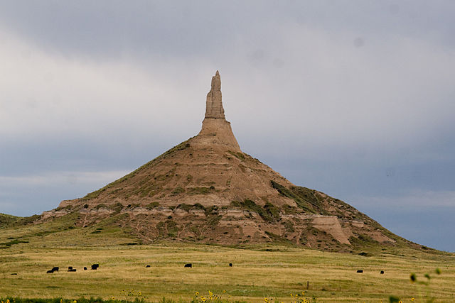
Courthouse and Jail Rocks are two rock formations located near Bridgeport in the Nebraska Panhandle. The Oregon-California Trail, the Mormon Trail, the Pony Express Trail, the pair of rock formations served as a landmark along the trails for many pioneers traveling west in the 19th century. Many travelers would stray as much as five miles from the Oregon Trail just to get a glimpse of the rocks, hundreds of westward-bound emigrants mentioned Courthouse Rock in their travel logs and journals. The name Courthouse was first used in 1837, the voyagers have called it the Courthouse, but it looks infinitely more like the Capitol. Courthouse and Jail Rocks, which rise 400 feet above the North Platte Valley, are composed of Brule clay, Gering sandstone, the rock formations are listed in the National Register of Historic Places and in the Nebraska Natural Areas Register. Robert Stuart first recorded Court House and Jail House Rock in 1812, by 1849 and the California Gold Rush, the promontories had been described as Castles, a Church, and Coffins. The name Court House and Jail House became the most common, Pumpkin Creek forms an oxbow near the buttes where a meadow with trees make an suitable campsite. There is evidence that fur trappers, Indians, gold seekers on their way to California and the Black Hills, further to the southeast on Pumpkin Creek, is the site of a Pony Express Station. The Pony Express and the military used a route on the west side as did the Sidney-Black Hills Trail. The buttes are the first promontories along the trail coming from the east, even for those emigrants who used the Julesburg, Colorado crossing of the South Platte River, the buttes are mentioned in their diaries. Court House and Jail House Rocks are remnants of an ancient plateau and they are remnants of the nearby hills that have become separated over time. At an elevation of 4,050 feet above sea level they rise 240 feet above Pumpkin Creek, Courthouse and Jail Rocks, which rise 400 feet above the North Platte Valley, are composed of Brule clay, Gering sandstone and volcanic ash. The rock formations are listed in the National Register of Historic Places, landmarks of the Nebraska Territory Chimney Rock National Historic Site
31.
Sandhills (Nebraska)
–
The Sandhills, often written Sand Hills, is a region of mixed-grass prairie on grass-stabilized sand dunes in north-central Nebraska, covering just over one quarter of the state. The dunes were designated a National Natural Landmark in 1984. The sandhills are found in Arthur, Blaine, Brown, Cherry, Custer, Garden, Garfield, Grant, Holt, Hooker, Lincoln, Keith, Logan, Loup, McPherson, Morrill, Rock, Sheridan, Thomas, and Wheeler counties. The boundaries of the Sandhills are variously defined by different organizations, depending on the definition, the regions area can be as small as 19,600 mi2 or as large as 23,600 mi2. Dunes in the Sandhills may exceed 330 ft in height, the average elevation of the region gradually increases from about 1,800 ft in the east to about 3,600 ft in the west. The Sandhills sit atop the massive Ogallala Aquifer, thus both temporary and permanent shallow lakes are common in low-lying valleys between the grass-stabilized dunes prevalent in the Sandhills. The eastern and central sections of the region are drained by tributaries of the Loup River, the World Wide Fund for Nature designated the Sandhills as an ecoregion, distinct from other grasslands of the Great Plains. According to their assessment, as much as 85% of the ecoregion is intact natural habitat and this is chiefly due to the lack of crop production, most of the Sandhills land has never been plowed. Much of the area was a desert, with desert-like conditions extending to several other states. The plant-anchored dunes of the Sandhills were long considered an irreclaimable desert, in the 1870s, cattlemen began to discover their potential as rangeland for Longhorn cattle. The fragility of the soil makes the area unsuitable for cultivation of crops. Unsuccessful attempts at farming were made in the region in the late 1870s, some development of cropland agriculture in the modern era has occurred through the use of center-pivot irrigation systems. The 1904 Kinkaid Act allowed homesteaders to claim 640 acres of land, nearly nine million acres were successfully claimed by Kinkaiders between 1910 and 1917. Some of the Kinkaiders attempted to farm, but these attempts generally failed and this included Nebraskas largest black settlement, DeWitty, which was located in southeast Cherry County until the 1930s. Many of the largest ranches broke up about the time due to regulations against fencing federal range lands. In the 21st century, the Sandhills are a cattle ranching area. The population of the region continues to decline as older generations die out, however, a number of small towns remain in the region. As the largest and most intricate wetland ecosystem in the United States, minimal crop production has led to limited land fragmentation, the resulting extensive and continuous habitat for plant and animal species has largely preserved the biodiversity of the area
32.
Chimney Rock State Park
–
Chimney Rock State Park is a North Carolina state park in Chimney Rock, Rutherford County, North Carolina in the United States. The 6, 807-acre park is located 25 miles southeast of Asheville, North Carolina and it offers hiking trails for all skill levels, spectacular views, the Devils Head balancing rock and a 404-foot waterfall, Hickory Nut Falls. Its most notable feature is a 315-foot rock formation, a monolith, Chimney Rock, accessible by elevator and providing views of the park. In May 2005, the North Carolina General Assembly authorized the creation of the Hickory Nut Gorge State Park, world’s Edge contains a mile-long set of steep slopes on the eastern edge of the Blue Ridge Escarpment, with more than 20,000 feet of streams and waterfalls. From an overlook point, the land away to provide a stunning view of the Piedmont. Transfer of the Worlds Edge tract to state ownership was completed in 2006, in 1902, Dr. Lucius B. Morse purchased 64 acres at Chimney Rock Mountain, including the Chimney and cliffs. Morse and his family owned and operated Chimney Rock Park as a privately managed park from 1902 to 2007, many small tracts purchased over the years expanded the Park to 996 acres. In 2006 the land was put up for sale, the park will continue to be managed by Chimney Rock Management LLC through at least 2011. The state will begin receiving licensing fees based on a percentage of gross revenues, during this time, the state will continue its efforts to acquire land and develop a master plan for the new park, which is now 4,531 acres. Official website Chimney Rock Attraction Session Law 2005-26 established Hickory Nut Gorge State Park, Session Law 2007-307 changed the name of Hickory Nut Gorge State Park to Chimney Rock State Park
33.
Federal Writers' Project
–
The Federal Writers Project was a United States federal government project to fund written work and support writers during the Great Depression. It was part of the Works Progress Administration, a New Deal program and it was one of a group of New Deal arts programs known collectively as Federal Project Number One. Funded under the Emergency Relief Appropriation Act of 1935, the Federal Writers Project was established July 27,1935, by President Franklin Delano Roosevelt. The project operated under journalist and theatrical producer Henry Alsberg, and later John D. Newsome, compiling local histories, oral histories, ethnographies, childrens books, the most well-known of these publications were the 48 state guides to the United States known as the American Guide Series. The format was uniform, comprising essays on the history and culture, descriptions of its major cities, automobile tours were one of the important attractions. The Federal Writers Project was funded and put to work, as a Public Works in and around the west coast, through Washington, Oregon, the Federal Writers Project was charged with employing writers, editors, historians, researchers, art critics, archaeologists, geologists and cartographers. Some 6,600 individuals were employed by the Federal Writers Project, in each state a Writers Project non-relief staff of editors was formed, along with a much larger group of field workers drawn from local unemployment rolls. Many of these had never completed school, but most had formerly held white collar jobs of some sort. Most of the Writers Project employees were young in age. Some Federal Writers Project writers supported the movement and left-wing social and political themes. The rise of fascism and the opposition to Roosevelt administration policies by conservative critics led many WPA artists to voice a political position. Most Writers Project works were apolitical by their nature, but some histories and ethnographies were not, some projects were strongly opposed by some state legislatures, particularly the American Guide Series books, and in a few states Guide printings were kept to a minimal number of copies. Some of the work was an art in the sense that these were not attempts to sugar-coat the lives of the authentic folk in the realm of culture. Roosevelt Presidential Library, Marist College, and IBM, adding, The times had provided a human drama of immense proportions, thus, many fiction writers turned toward documenting the common people, those who suffered most brutally the effects of the Depression. The results were such books as Jack Conroys The Disinherited and John Steinbecks enduring classic The Grapes of Wrath, thousands worked on the project, including several well-known authors. Blakey estimates that at any one time the Indiana office had no fewer than 150 men and women on the payroll, fieldworkers made about $80 a month, working 20 to 30 hours a week. Very few African Americans worked for the projects, with the notable exception of the Illinois Writers Project. Federal sponsorship for the Federal Writers Project came to an end in 1939, a National Endowment for the Humanities-funded documentary about the Federal Writers Project, entitled Soul of a People, Writing Americas Story premiered on the Smithsonian Channel in September 2009
34.
Nauvoo, Illinois
–
Nauvoo is a small city in Hancock County, Illinois, United States, on the Mississippi River near Fort Madison, Iowa. The population of Nauvoo was 1,149 at the 2010 census, the city and its immediate surrounding area are listed on the National Register of Historic Places as the Nauvoo Historic District. The area of Nauvoo was first called Quashquema, named in honor of the Native American chief who headed a Sauk, by 1827, white settlers had built cabins in the area. By 1829 this area of Hancock County had grown sufficiently so that a post office was needed and in 1832 the town, however, the honor was awarded to a nearby city, Carthage. In 1834 the name Venus was changed to Commerce because the settlers felt that the new name better suited their plans, the name Nauvoo is derived from the traditional Hebrew language with an anglicized spelling. The word comes from Isaiah 52,7, “How beautiful upon the mountains. ”It is notable that “by 1844 Nauvoos population had swollen to 12,000, after Joseph Smiths death in 1844, continuing violence from surrounding non-Mormons forced most Latter-Day Saints to leave Nauvoo. Most of these refugees, led by Brigham Young, eventually emigrated to the Great Salt Lake Valley, in 1849, Icarians moved to the Nauvoo area to implement a utopian socialist commune based on the ideals of French philosopher Étienne Cabet. At its peak the colony numbered over 500 members, but Cabets death in 1856 caused some members to leave this parent colony, in the early and mid 20th century Nauvoo was primarily a Roman Catholic town, and the majority of the population today is Catholic. Guided tours are available at the churchs Joseph Smith Historic Site, located at the end of the town. The LDS Church owns most of the historic sites in Nauvoo, including the homes of Brigham Young. Kimball, and other members of the church, as well as other significant buildings. Most of these sites are open to the public, with demonstrations and displays and these tours are free, as are the stage and riverside theatrical productions. There is a visitors center complete with two theaters and a relief map of 1846 Nauvoo. The creation of Nauvoo as a tourism destination was largely a result of the work of J. LeRoy Kimball. Kimball was a descendent of early Mormon leader Heber C, Kimball, and bought his ancestors home in 1954 with the intention of restoring it. He was the president of Nauvoo Restoration, Inc. from 1962 to 1986, an LDS congregation was established in Nauvoo in 1956, from its inception consisting largely of elderly LDS couples serving as missionaries and historical guides. The City of Joseph Pageant, a musical produced by the LDS Church. An LDS stake was organized with headquarters at Nauvoo in 1979, in addition to the many homes that had been restored, the Relief Society Memorial Garden was dedicated in 1978, featuring statues designed by Dennis Smith and Florence Hansen
35.
Emigrant Trail in Wyoming
–
The path followed by the Oregon Trail, California Trail and Mormon Trail spans 400 miles through the U. S. state of Wyoming. The trail entered from Nebraska on the border of the state near the present day town of Torrington and exited on the western border near the towns of Cokeville. An estimated 350,000 to 400,000 settlers traveled on the trail through Wyoming between 1841 and 1868, all three trails follow the same path through most of the state. The Mormon Trail splits at Fort Bridger and enters Utah, while the Oregon, in the eastern plains, the Emigrant Trail follows the North Platte River into Wyoming. The trail follows the river upstream to Fort Laramie, a prominent military, after crossing, trains on the main trail to the south of the river had to cross the North Platte again 100 miles upstream. In 1850 several wagon trains successfully blazed a path along the side of the river. This new route, which reduced the risk and expense of crossing the river twice, was preferred for all subsequent traffic on the side of the river. The northern route is sometimes called Childs Route after Andrew Child who describe it in a book published in 1852. Above Fort Laramie, Childs Route follows the North Platte River through the present day town of Douglas and this is the point at which the Bozeman Trail turned north to the gold fields of Montana in the 1860s. The southern route also follows the river along the edge of the Laramie Mountains to an area near the current towns of Casper, in 1847, during the first Mormon emigration, Brigham Young established a ferry near present-day Casper known as Mormon Ferry. The next year the ferry was moved a few miles downriver, the ferry was free for Latter Day Saints, but charged a toll for other users. The ferry was manned by groups of Mormons every summer from 1848 until 1852, in 1853 John Baptiste Richard built a toll bridge near the ferry site, which would eventually put all ferries on the North Platte out of business. In 1859, Louis Guinard built the Platte Bridge near the site of the original Mormon Ferry, Guinard also built a trading post at one end of the bridge which eventually became Fort Caspar. Famous landmarks along the route included Ayres Natural Bridge and Register Cliff. Continuing upstream from Casper, the North Platte bends to the south, the original trail proceeded several miles along the river to Red Buttes, where a bend in the river formed a natural amphitheater dominated by red cliffs on the hill above. The river was easier to ford here for those who were unwilling or unable to pay to cross at one of the ferries downstream and this was the last good camp spot before leaving the river and entering the waterless stretch between the North Platte and the Sweetwater River. From here the settlers entered a difficult portion called Rock Avenue which moved from spring to spring across mostly alkaline soil, upon arrival in the Sweetwater valley, the trail encounters one of the most important landmarks on the trail, Independence Rock. Independence Rock was named because settlers tried to reach it by July 4 in order to ensure that they will be at their destinations in California or Oregon before the winter snows come
36.
Devil's Gate (Wyoming)
–
Devils Gate or Devils Gate is a natural rock formation, a gorge on the Sweetwater River in Wyoming a few miles southwest of Independence Rock. Although the actual route of travel did not pass through the cleft, the site was a major landmark on the Oregon and Mormon trails. The earliest surviving photograph of this landmark was made in 1858 by Samuel C, mills, a photographer with the Captain Simpson Expedition. The canyon is accessible today from Wyoming Highway 220 between Casper and Muddy Gap, near the Mormon Handcart Historic Site and Martins Cove, Devils Gate is a remarkable example of superposed or an antecedent drainage stream. The Sweetwater River cuts a narrow 100-meter deep slot through a ridge, yet had it flowed less than a kilometer to the south. The gorge was cut because the landscape was originally buried by valley fill sediments, the river eroded downward and when it hit granite, kept on cutting. Media related to Devils Gate at Wikimedia Commons Devils Gate on the Oregon Trail
37.
Martin's Cove
–
Martins Cove is a historic site in Wyoming. The 933 acre cove is located 55 miles southwest of Casper, Wyoming and it is located on the Mormon Trail and is also part of the North Platte-Sweetwater segment of the Oregon Trail. The Cove was listed in the National Register of Historic Places on March 8,1977, in November 1856, about 500 Mormon emigrants in the Martin Handcart Company were halted for five days in the Cove by snow and cold while on their way to Salt Lake City. The Martin Handcart company had begun its journey on July 28,1856 which was late in the season. Although the number who died in the Cove is unknown, more than 145 members of the Martin Company died before reaching Salt Lake City, on November 4 the company and rescuers forded the bitterly cold Sweetwater River and sought shelter in the cove. That evening a powerful north wind blew the tents to the ground, the tents were set up again, but a blizzard brought heavy snow. The company remained in the camp for five days, unable to proceed due to the snow, a number of the companys cattle died there and were preserved in a frozen state. When the weather warmed, on November 9, the company was able to move on toward Utah, with assistance from the original rescue party and from additional rescue parties that met them along the way, the survivors finally reached Salt Lake City on November 30. Later many other emigrants would pass by the Cove on their way to Utah, California, during the 1870s, Tom Sun, a French-Canadian frontiersman, purchased the area around the Cove and established Sun Ranch. Following the LDS Churchs purchase of nearby Sun Ranch in the 1990s it tried to purchase the Martins Cove property, to operate it as a historic site. In 2002, a bill for the sale of the property passed the House but then stalled in the Senate. The concerns were mainly the result of the land including areas commonly used as campgrounds by emigrant trains, the Pony Express, as a result, the Bureau of Land Management, part of the Interior Department, had to negotiate a long-term lease with the Church. This lease was signed in 2004, and allowed the Church to manage, the Churchs volunteers at the site were also required to simply answer questions rather than approach visitors with anything that could be interpreted as proselytizing. About 100,000 people visit the site each year, of which the majority are members of The Church of Jesus Christ of Latter-day Saints, every year thousands of LDS Youth participate in Handcart Treks through the area near Martins Cove. These Treks involve dressing up in period clothing while spending several days pulling handcarts, the highlight of their Trek is visiting Martins Cove and nearby Devils Gate along with the LDS Visitors Center
38.
Names Hill
–
Names Hill is a bluff located on the bank of the Green River in the U. S. state of Wyoming, where travelers on the Oregon and California trails carved their names into the rock. It is one of three notable recording areas along the emigrant trails in Wyoming along with Register Cliff and Independence Rock, Names Hill was located near a heavily used crossing of the Green River. The earliest human recordings at the site are Native American pictographs, european American names began appearing as early as 1822 as mountain men crossed the river on their way to the beaver streams of the Western Rocky Mountains. In 1844, Caleb Greenwood and Isaac Hitchcock lead the first wagon train over what would later be called the Sublette-Greenwood Cutoff, along the way crossing the Green River at Names Hill. The wagon trails would rest at the Green River following a 40 miles waterless trek across the prairie, among the more famous names inscribed on the rock is famed mountain man Jim Bridger. Some have disputed the authenticity of the signature as Bridger was thought have been illiterate, the site was listed on the National Register of Historic Places on April 16,1969. Keyser, James D. George R. Poetschat, James D Keyser, George R Poetschat, warrior Art of Wyomings Green River Basin, Biographic Petroglyphs Along the Seedskadee. List of Emigrants Names Carved on Names Hill and Holden Hill on Green River, Names Hill at the Wyoming State Historic Preservation Office
39.
Register Cliff
–
An estimated 500,000 emigrants used these trails from 1843–1869, with up to one-tenth dying along the way, usually due to disease. Register Cliff is the easternmost of the three prominent emigrant recording areas located within Wyoming, the two being Independence Rock and Names Hill. The site was listed on the National Register of Historic Places in 1969, according to its nomination, the site was where emigrants would camp on their first night west of Fort Laramie. The property was donated by Henry Frederick to the state of Wyoming, to be preserved
40.
South Pass (Wyoming)
–
South Pass is the collective term for two mountain passes on the Continental Divide, in the Rocky Mountains in southwestern Wyoming. South Pass is the lowest point on the Continental Divide between the Central Rocky Mountains and the Southern Rocky Mountains, the passes furnish a natural crossing point of the Rockies. The historic pass became the route for emigrants on the Oregon, California and it has been designated as a U. S. National Historic Landmark. The pass is an open saddle with prairie and sagebrush, allowing a broad. The Sweetwater River flows past the east side of the pass, Historic South Pass is the lower of the two passes, and was the easy crossing point used by emigrants. Wyoming highway 28 crosses the Continental Divide 2.5 miles to the northwest at elevation 7,550 feet, and its crossing is also named South Pass. The Lander Cutoff Route crosses the Continental Divide at the far northwest end of the broad South Pass region, about 25 miles to the northwest of the South Passes, at an elevation of 8,030 feet. Because the Lewis and Clark Expedition was searching for a route across the Continental Divide. Instead, the followed a northerly route up the Missouri River. In 1856 Ramsay Crooks, one of the party, wrote a letter describing their journey, In 1811, pursuing from thence an easterly course, they fell upon the River Platte of the Missouri, where they passed the winter and reached St. Louis in April,1813. Despite Stuarts meticulous journal of the trip, which he presented to Astor and President James Madison, and published in France, for more than a decade, European-American trappers continued to use a longer, more northern route. It included a mountain range to be crossed and had a shorter season for crossing. In 1823 a St. Louis merchant named W. H. Ashley led a party up the Sweetwater to its source, rediscovered the pass, in 1832 Captain Benjamin Bonneville and a caravan of 110 men and 20 wagons became the first group to take wagons over the pass. In July 1836, Narcissa Whitman and Eliza Spalding were the first white women to cross South Pass. Between 1848 and 1868, South Pass was the crossing point for emigrants westward, most of whom followed the Sweetwater River across Wyoming to its headwaters. Before the railroads offered an easier crossing in 1869, perhaps half a million emigrants would trek through South Pass, gold had been discovered in the gulches near the pass as early as 1842. However, it was not until 1867, when an ore sample was transported to Salt Lake City, the gold rush led to the establishment of booming mining communities such as South Pass City and Atlantic City. The placer gold in the streams was exhausted quickly, however, in 1884, Emile Granier, a French mining engineer, established a hydraulic drilling operation that allowed gold mining to continue
41.
Emigration Canyon, Utah
–
Emigration Canyon is a CDP, township and canyon in Salt Lake County, Utah, United States, located east of Salt Lake City in the Wasatch Range. Beginning at the end of the University of Utah, the canyon itself heads east and northeast between Salt Lake City and Morgan County. The boundaries of the CDP and township are coextensive, they do not extend to the county line, as of the 2010 census, the population was 1,567. Emigration Canyon was declared a National Historic Landmark in 1961 and it is significant in Utah history as the original route used by pioneers entering Utah. It was part of the Hastings Cutoff route used by the Donner Party in 1846, as Brigham Young looked over the canyon, he declared, This is the right place. These words have become famous in Utah history, the event is commemorated with This Is The Place Heritage Park at the mouth of the canyon. Throughout Emigration Canyon, there are historic markers designating camps, trail markers. One example of these milestones is called Lost Creek Camp, hogle Zoo, the main zoo in the Salt Lake City area, also lies at the mouth of the canyon. Emigration Canyon is home to Camp Kostopulos and the Kostopulos Dream Foundation, established in 1967, Camp Kostopulos is a summer camp for disabled children, teens, and Adults. It is adjacent to the historic Ruths Diner, the 8-mile-long Emigration Canyon road has become a popular destination for cyclists, with its gradual climb and quick descent, because of its convenient location next to Salt Lake City. Mormon Trail Media related to Emigration Canyon, Utah at Wikimedia Commons Emigration Canyon Online Emigration Canyon Trails Master Plan Utah. com
42.
National Register of Historic Places
–
The National Register of Historic Places is the United States federal governments official list of districts, sites, buildings, structures, and objects deemed worthy of preservation. The passage of the National Historic Preservation Act in 1966 established the National Register, of the more than one million properties on the National Register,80,000 are listed individually. The remainder are contributing resources within historic districts, each year approximately 30,000 properties are added to the National Register as part of districts or by individual listings. For most of its history the National Register has been administered by the National Park Service and its goals are to help property owners and interest groups, such as the National Trust for Historic Preservation, coordinate, identify, and protect historic sites in the United States. While National Register listings are mostly symbolic, their recognition of significance provides some financial incentive to owners of listed properties, protection of the property is not guaranteed. During the nomination process, the property is evaluated in terms of the four criteria for inclusion on the National Register of Historic Places, the application of those criteria has been the subject of criticism by academics of history and preservation, as well as the public and politicians. Occasionally, historic sites outside the proper, but associated with the United States are also listed. Properties can be nominated in a variety of forms, including individual properties, historic districts, the Register categorizes general listings into one of five types of properties, district, site, structure, building, or object. National Register Historic Districts are defined geographical areas consisting of contributing and non-contributing properties, some properties are added automatically to the National Register when they become administered by the National Park Service. These include National Historic Landmarks, National Historic Sites, National Historical Parks, National Military Parks/Battlefields, National Memorials, on October 15,1966, the Historic Preservation Act created the National Register of Historic Places and the corresponding State Historic Preservation Offices. Initially, the National Register consisted of the National Historic Landmarks designated before the Registers creation, approval of the act, which was amended in 1980 and 1992, represented the first time the United States had a broad-based historic preservation policy. To administer the newly created National Register of Historic Places, the National Park Service of the U. S. Department of the Interior, hartzog, Jr. established an administrative division named the Office of Archeology and Historic Preservation. Hartzog charged OAHP with creating the National Register program mandated by the 1966 law, ernest Connally was the Offices first director. Within OAHP new divisions were created to deal with the National Register, the first official Keeper of the Register was William J. Murtagh, an architectural historian. During the Registers earliest years in the late 1960s and early 1970s, organization was lax and SHPOs were small, understaffed, and underfunded. A few years later in 1979, the NPS history programs affiliated with both the U. S. National Parks system and the National Register were categorized formally into two Assistant Directorates. Established were the Assistant Directorate for Archeology and Historic Preservation and the Assistant Directorate for Park Historic Preservation, from 1978 until 1981, the main agency for the National Register was the Heritage Conservation and Recreation Service of the United States Department of the Interior. In February 1983, the two assistant directorates were merged to promote efficiency and recognize the interdependency of their programs, jerry L. Rogers was selected to direct this newly merged associate directorate