1.
Frank Rinehart
–
German American Rinehart was born in Lodi, Illinois. He and his brother, Alfred, moved to Colorado in the 1870s and found employment at the Charles Bohm photography studio, in 1881 the Rinehart brothers formed a partnership with famous Western photographer William Henry Jackson, who had achieved widespread fame for his images of the West. Under Jacksons teachings, Rineharts perfected his skills, and developed a keen interest in Native American culture. Frank Rinehart and Anna, the receptionist of Jacksons studio, married, in downtown Omaha, Rinehart opened a studio in the Brandeis Building, where he worked until his death. Rinehart married Anna Ransom Johnson on 5 September 1885 in Denver County and they had two daughters, Ruth and Helen, both born in Nebraska. Together with his assistant Adolph Muhr, they produced what is now considered one of the best photographic documentations of Indian leaders at the turn of the century, instead of being detached, ethnographic records, the Rinehart photographs are portraits of individuals with an emphasis on strength of expression. Rinehart and Muhr photographed American Indians at the Indian Congress in a studio on the Exposition grounds with an 8 x 10 glass-negative camera with a German lens, platinum prints were produced to achieve the broad range of tonal values that medium afforded. The collection of Rinehart Indian Photographs is currently preserved at Haskell Indian Nations University, since 1994, the collection has been organized, preserved, copied, and cataloged in a computer database, funded by the Bureau of Indian Affairs and the Hallmark Foundation. It includes images from the 1898 Exposition, the 1899 Greater American Exposition, studio portraits from 1900, beyond the Reach of Time and Change, Native American Reflections on the Frank A. Rinehart Photograph Collection, by Simon J. Ortiz. University of Arizona Press LJWorld Photogalleries, Frank Rinehart U. S. department of Interior Museum Boston Public Library
2.
Mexico
–
Mexico, officially the United Mexican States, is a federal republic in the southern half of North America. It is bordered to the north by the United States, to the south and west by the Pacific Ocean, to the southeast by Guatemala, Belize, and the Caribbean Sea, and to the east by the Gulf of Mexico. Covering almost two million square kilometers, Mexico is the sixth largest country in the Americas by total area, Mexico is a federation comprising 31 states and a federal district that is also its capital and most populous city. Other metropolises include Guadalajara, Monterrey, Puebla, Toluca, Tijuana, pre-Columbian Mexico was home to many advanced Mesoamerican civilizations, such as the Olmec, Toltec, Teotihuacan, Zapotec, Maya and Aztec before first contact with Europeans. In 1521, the Spanish Empire conquered and colonized the territory from its base in Mexico-Tenochtitlan, Three centuries later, this territory became Mexico following recognition in 1821 after the colonys Mexican War of Independence. The tumultuous post-independence period was characterized by instability and many political changes. The Mexican–American War led to the cession of the extensive northern borderlands, one-third of its territory. The Pastry War, the Franco-Mexican War, a civil war, the dictatorship was overthrown in the Mexican Revolution of 1910, which culminated with the promulgation of the 1917 Constitution and the emergence of the countrys current political system. Mexico has the fifteenth largest nominal GDP and the eleventh largest by purchasing power parity, the Mexican economy is strongly linked to those of its North American Free Trade Agreement partners, especially the United States. Mexico was the first Latin American member of the Organisation for Economic Co-operation and Development and it is classified as an upper-middle income country by the World Bank and a newly industrialized country by several analysts. By 2050, Mexico could become the fifth or seventh largest economy. The country is considered both a power and middle power, and is often identified as an emerging global power. Due to its culture and history, Mexico ranks first in the Americas. Mexico is a country, ranking fourth in the world by biodiversity. In 2015 it was the 9th most visited country in the world, Mexico is a member of the United Nations, the World Trade Organization, the G8+5, the G20, the Uniting for Consensus and the Pacific Alliance. Mēxihco is the Nahuatl term for the heartland of the Aztec Empire, namely, the Valley of Mexico, and its people, the Mexica and this became the future State of Mexico as a division of New Spain prior to independence. It is generally considered to be a toponym for the valley became the primary ethnonym for the Aztec Triple Alliance as a result. After New Spain won independence from Spain, representatives decided to name the new country after its capital and this was founded in 1524 on top of the ancient Mexica capital of Mexico-Tenochtitlan
3.
Baja California
–
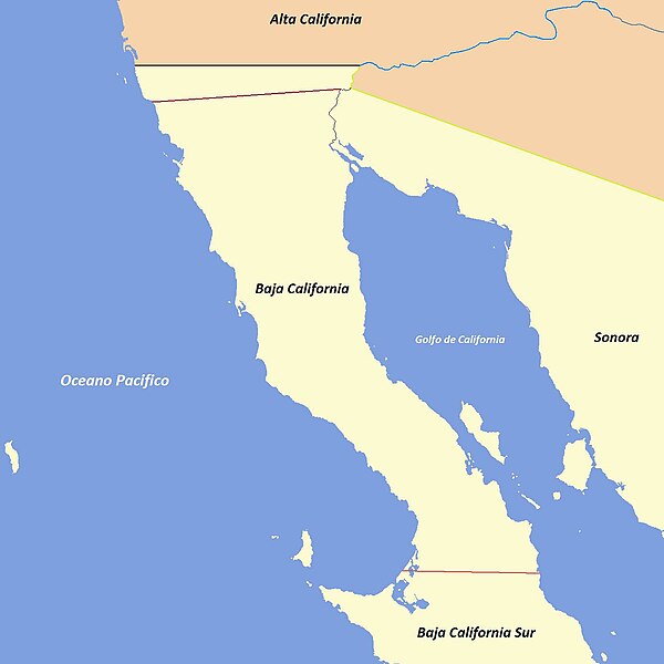
Baja California, officially the Free and Sovereign State of Baja California, is a state in Mexico. It is the northernmost and westernmost of the 32 Federal Entities of Mexico, before becoming a state in 1952, the area was known as the North Territory of Baja California. It has an area of 70,113 km2, or 3. 57% of the mass of Mexico and comprises the northern half of the Baja California Peninsula, north of the 28th parallel. The mainland portion of the state is bordered on the west by the Pacific Ocean, on the east by Sonora, the U. S. State of Arizona, and the Gulf of California and its northern limit is the U. S. state of California. The state has an population of 3,165,776 much more than the sparsely populated Baja California Sur to the south. Over 75% of the lives in the capital city, Mexicali, in Ensenada. Other important cities include San Felipe, Rosarito and Tecate, additionally, there is a large immigrant population from the United States due to its proximity to San Diego and the cheaper cost of living compared to San Diego. There is also a significant population from Central America, many immigrants moved to Baja California for a better quality of life and the number of higher paying jobs in comparison to the rest of Mexico and Latin America. Baja California is the twelfth largest state by area in Mexico and its geography ranges from beaches to forests and deserts. The backbone of the state is the Sierra de Baja California, where the Picacho del Diablo and this mountain range effectively divides the weather patterns in the state. In the northwest, the weather is semi-dry and mediterranean, in the narrow center, the weather changes to be more humid due to altitude. It is in area where a few valleys can be found, such as the Valle de Guadalupe. To the east of the range, the Sonoran Desert dominates the landscape. In the south, the weather becomes drier and gives way to the Vizcaino Desert, the state is also home to numerous islands off both of its shores. In fact, the westernmost point in Mexico, the Guadalupe Island, is part of Baja California, the Coronado, Todos Santos and Cedros Islands are also on the Pacific Shore. On the Gulf of California, the biggest island is the Angel de la Guarda, separated from the peninsula by the deep, the first people came to the peninsula at least 11,000 years ago. At that time two main groups are thought to have been present on the peninsula. In the south were the Cochimí, in the north were several groups belonging to the Yuman language family, including the Kiliwa, Paipai, Kumeyaay, Cocopa, and Quechan
4.
Sonora
–
Sonora, officially the Free and Sovereign State of Sonora, is one of 31 states that, with Mexico City, comprise the 32 federal entities of Mexico. It is divided into 72 municipalities, the city is Hermosillo. Sonora is located in Northwest Mexico, bordered by the states of Chihuahua to the east, Baja California to the northwest and Sinaloa to the south. To the north, it shares the U. S. –Mexico border with the states of Arizona and New Mexico, and on the west has a significant share of the coastline of the Gulf of California. Sonoras natural geography is divided into three parts, the Sierra Madre Occidental in the east of the state, plains and rolling hills in the center, and the coast on the Gulf of California. It is primarily arid or semiarid deserts and grasslands, with only the highest elevations having sufficient rainfall to support other types of vegetation, Sonora is home to eight indigenous peoples, including the Mayo, the Yaqui, and Seri. It has been important for its agriculture, livestock, and mining since the colonial period. With the Gadsden Purchase, Sonora lost more than a quarter of its territory, from the 20th century to the present, industry, tourism, and agribusiness have dominated the economy, attracting migration from other parts of Mexico. Several theories exist as to the origin of the name Sonora and they encountered the Opata, who could not pronounce Señora, instead saying Senora or Sonora. A third theory, written by Father Cristóbal de Cañas in 1730, states that the name comes from the word for a water well, sonot. The first record of the name Sonora comes from explorer Francisco Vásquez de Coronado, Francisco de Ibarra also traveled through the area in 1567 and referred to the Valles de Señora. Evidence of human existence in the dates back over 10,000 years. The first humans were hunter gatherers who used tools made from stones, seashells. During much of the period, the environmental conditions were less severe than they are today, with similar. The oldest Clovis culture site in North America is believed to be El Fin del Mundo in northwestern Sonora and it was discovered during a 2007 survey. It features occupation dating around 13,390 calibrated years BP, in 2011, remains of Gomphothere were found, the evidence suggests that humans did in fact kill two of them here. Agriculture first appeared around 400 BCE and 200 CE in the river valleys, the lowland central coast, however, seems never truly to have adopted agriculture. Because Sonora and much of the northwest does not share many of the traits of that area
5.
United States
–
Forty-eight of the fifty states and the federal district are contiguous and located in North America between Canada and Mexico. The state of Alaska is in the northwest corner of North America, bordered by Canada to the east, the state of Hawaii is an archipelago in the mid-Pacific Ocean. The U. S. territories are scattered about the Pacific Ocean, the geography, climate and wildlife of the country are extremely diverse. At 3.8 million square miles and with over 324 million people, the United States is the worlds third- or fourth-largest country by area, third-largest by land area. It is one of the worlds most ethnically diverse and multicultural nations, paleo-Indians migrated from Asia to the North American mainland at least 15,000 years ago. European colonization began in the 16th century, the United States emerged from 13 British colonies along the East Coast. Numerous disputes between Great Britain and the following the Seven Years War led to the American Revolution. On July 4,1776, during the course of the American Revolutionary War, the war ended in 1783 with recognition of the independence of the United States by Great Britain, representing the first successful war of independence against a European power. The current constitution was adopted in 1788, after the Articles of Confederation, the first ten amendments, collectively named the Bill of Rights, were ratified in 1791 and designed to guarantee many fundamental civil liberties. During the second half of the 19th century, the American Civil War led to the end of slavery in the country. By the end of century, the United States extended into the Pacific Ocean. The Spanish–American War and World War I confirmed the status as a global military power. The end of the Cold War and the dissolution of the Soviet Union in 1991 left the United States as the sole superpower. The U. S. is a member of the United Nations, World Bank, International Monetary Fund, Organization of American States. The United States is a developed country, with the worlds largest economy by nominal GDP. It ranks highly in several measures of performance, including average wage, human development, per capita GDP. While the U. S. economy is considered post-industrial, characterized by the dominance of services and knowledge economy, the United States is a prominent political and cultural force internationally, and a leader in scientific research and technological innovations. In 1507, the German cartographer Martin Waldseemüller produced a map on which he named the lands of the Western Hemisphere America after the Italian explorer and cartographer Amerigo Vespucci
6.
Arizona
–
Arizona is a state in the southwestern region of the United States. It is also part of the Western United States and the Mountain West states and it is the sixth largest and the 14th most populous of the 50 states. Its capital and largest city is Phoenix, Arizona is one of the Four Corners states. It has borders with New Mexico, Utah, Nevada, California, and Mexico, Arizonas border with Mexico is 389 miles long, on the northern border of the Mexican states of Sonora and Baja California. Arizona is the 48th state and last of the states to be admitted to the Union. Historically part of the territory of Alta California in New Spain, after being defeated in the Mexican–American War, Mexico ceded much of this territory to the United States in 1848. The southernmost portion of the state was acquired in 1853 through the Gadsden Purchase, Southern Arizona is known for its desert climate, with very hot summers and mild winters. There are ski resorts in the areas of Flagstaff, Alpine, in addition to the Grand Canyon National Park, there are several national forests, national parks, and national monuments. To the European settlers, their pronunciation sounded like Arissona, the area is still known as alĭ ṣonak in the Oodham language. Another possible origin is the Basque phrase haritz ona, as there were numerous Basque sheepherders in the area, There is a misconception that the states name originated from the Spanish term Árida Zona. See also lists of counties, islands, rivers, lakes, state parks, national parks, Arizona is in the Southwestern United States as one of the Four Corners states. Arizona is the sixth largest state by area, ranked after New Mexico, of the states 113,998 square miles, approximately 15% is privately owned. The remaining area is public forest and park land, state trust land, Arizona is well known for its desert Basin and Range region in the states southern portions, which is rich in a landscape of xerophyte plants such as the cactus. This regions topography was shaped by volcanism, followed by the cooling-off. Its climate has hot summers and mild winters. The state is well known for its pine-covered north-central portion of the high country of the Colorado Plateau. Like other states of the Southwest United States, Arizona has an abundance of mountains, despite the states aridity, 27% of Arizona is forest, a percentage comparable to modern-day France or Germany. The worlds largest stand of pine trees is in Arizona
7.
Spanish language
–
Spanish —also called Castilian —is a Romance language that originated in the Castile region of Spain, with hundreds of millions of native speakers around the world. It is usually considered the worlds second-most spoken native language after Mandarin Chinese and it is one of the few languages to use inverted question and exclamation marks. Spanish is a part of the Ibero-Romance group of languages, which evolved from several dialects of Vulgar Latin in Iberia after the collapse of the Western Roman Empire in the 5th century. Beginning in the early 16th century, Spanish was taken to the colonies of the Spanish Empire, most notably to the Americas, as well as territories in Africa, Oceania, around 75% of modern Spanish is derived from Latin. Greek has also contributed substantially to Spanish vocabulary, especially through Latin, Spanish vocabulary has been in contact from an early date with Arabic, having developed during the Al-Andalus era in the Iberian Peninsula. With around 8% of its vocabulary being Arabic in origin, this language is the second most important influence after Latin and it has also been influenced by Basque as well as by neighboring Ibero-Romance languages. It also adopted words from languages such as Gothic language from the Visigoths in which many Spanish names and surnames have a Visigothic origin. Spanish is one of the six languages of the United Nations. It is the language in the world by the number of people who speak it as a mother tongue, after Mandarin Chinese. It is estimated more than 437 million people speak Spanish as a native language. Spanish is the official or national language in Spain, Equatorial Guinea, speakers in the Americas total some 418 million. In the European Union, Spanish is the tongue of 8% of the population. Spanish is the most popular second language learned in the United States, in 2011 it was estimated by the American Community Survey that of the 55 million Hispanic United States residents who are five years of age and over,38 million speak Spanish at home. The Spanish Constitution of 1978 uses the term castellano to define the language of the whole Spanish State in contrast to las demás lenguas españolas. Article III reads as follows, El castellano es la lengua española oficial del Estado, las demás lenguas españolas serán también oficiales en las respectivas Comunidades Autónomas. Castilian is the official Spanish language of the State, the other Spanish languages as well shall be official in their respective Autonomous Communities. The Spanish Royal Academy, on the hand, currently uses the term español in its publications. Two etymologies for español have been suggested, the Spanish Royal Academy Dictionary derives the term from the Provençal word espaignol, and that in turn from the Medieval Latin word Hispaniolus, from—or pertaining to—Hispania
8.
Quechan
–
Not to be confused with Quechua, South American language. The Quechan are a Native American tribe who live on the Fort Yuma Indian Reservation on the lower Colorado River in Arizona, members are enrolled into the Quechan Tribe of the Fort Yuma Indian Reservation. The federally recognized Quechan tribes main office is located in Fort Yuma and its operations and the majority of its reservation land are located in California, United States. The term Patayan is used by archaeologists to describe the prehistoric Native American cultures who inhabited parts of modern day Arizona, California and these areas included territory near the Colorado River Valley, the nearby uplands, and north to the vicinity of the Grand Canyon. The prehistoric people may have been ancestral to the Quechan and they practiced floodplain agriculture where possible, but relied heavily on hunting and gathering. The first significant contact of the Quechan with Europeans was with the Spanish explorer Juan Bautista de Anza, the chief Palma and his three companions were baptized in Mexico City on February 13,1777. Palma was given the Spanish baptismal name Salvador Carlos Antonio, Spanish settlement among the Quechan did not go smoothly, the tribe rebelled from July 17–19,1781 and killed four priests and thirty soldiers. They also attacked and damaged the Spanish mission settlements of San Pedro y San Pablo de Bicuñer and Puerto de Purísima Concepción, the following year, the Spanish retaliated with military action against the tribe. After the United States annexed the territories after winning the Mexican-American War, during which, the historic Fort Yuma was built across the Colorado River from the present day Yuma, Arizona. Estimates for the populations of most native groups in California have varied substantially. Alfred L. Kroeber put the 1770 population of the Quechan at 2,500, jack D. Forbes compiled historical estimates and suggested that before they were first contacted, the Quechan had numbered 4,000 or a few more. Kroeber estimated the population of the Quechan in 1910 as 750, by 1950, there were reported to be just under 1,000 Quechan living on the reservation and another 1, 100+ off it. The 2000 census reported a resident population of 2,376 persons on the Fort Yuma Indian Reservation, more than 27 percent identified as white. The Quechan language is part of the Yuman language family, the Fort Yuma Indian Reservation is a part of the Quechans traditional lands. Established in 1884, the reservation, at 32°47′N 114°39′W, has an area of 178.197 km2 in southeastern Imperial County, California. Both the county and city are named for the tribe, warriors of the Colorado, The Yumas of the Quechan Nation and Their Neighbors. Kroeber, A. L. Handbook of the Indians of California, a Native American Encyclopedia, History, Culture, and Peoples. Traders and Raiders, The Indigenous World of the Colorado Basin, chapel Hill, NC, University of North Carolina Press
9.
Fog
–
Fog consists of visible cloud water droplets or ice crystals suspended in the air at or near the Earths surface. Fog can be considered a type of low-lying cloud and is influenced by nearby bodies of water, topography. In turn, fog has affected many human activities, such as shipping, travel, the term fog is typically distinguished from the more generic term cloud in that fog is low-lying, and the moisture in the fog is often generated locally. By definition, fog reduces visibility to less than 1 kilometre, for aviation purposes in the UK, a visibility of less than 5 kilometres but greater than 999 metres is considered to be mist if the relative humidity is 70% or greater, below 70%, haze is reported. Fog forms when the difference between air temperature and dew point is less than 2.5 °C or 4 °F, Fog begins to form when water vapor condenses into tiny liquid water droplets suspended in the air. Water vapor normally begins to condense on condensation nuclei such as dust, ice, Fog, like its elevated cousin stratus, is a stable cloud deck which tends to form when a cool, stable air mass is trapped underneath a warm air mass. Fog normally occurs at a relative humidity near 100% and this occurs from either added moisture in the air, or falling ambient air temperature. However, fog can form at lower humidities, and can fail to form with relative humidity at 100%. At 100% relative humidity, the air cannot hold additional moisture, thus, Fog can form suddenly and can dissipate just as rapidly. The sudden formation of fog is known as flash fog, Fog commonly produces precipitation in the form of drizzle or very light snow. Drizzle occurs when the humidity of fog attains 100% and the cloud droplets begin to coalesce into larger droplets. This can occur when the fog layer is lifted and cooled sufficiently, drizzle becomes freezing drizzle when the temperature at the surface drops below the freezing point. The inversion boundary varies its altitude primarily in response to the weight of the air above it, the marine layer, and any fogbank it may contain, will be squashed when the pressure is high, and conversely, may expand upwards when the pressure above it is lowering. Fog can form in a number of ways, depending on how the cooling that caused the condensation occurred, radiation fog is formed by the cooling of land after sunset by thermal radiation in calm conditions with clear sky. The warm ground produces condensation in the air by heat conduction. In perfect calm the fog layer can be less than a meter deep, radiation fogs occur at night, and usually do not last long after sunrise, but they can persist all day in the winter months especially in areas bounded by high ground. Radiation fog is most common in autumn and early winter, examples of this phenomenon include the Tule fog. Ground fog is fog that obscures less than 60% of the sky, advection fog occurs when moist air passes over a cool surface by advection and is cooled
10.
Indigenous peoples of the Americas
–
The indigenous peoples of the Americas are the pre-Columbian peoples of the Americas and their descendants. The term Amerindian is used in Quebec, the Guianas, Indigenous peoples of the United States are commonly known as Native Americans or American Indians, and Alaska Natives. Application of the term Indian originated with Christopher Columbus, who, in his search for Asia, eventually, the Americas came to be known as the West Indies, a name still used to refer to the islands of the Caribbean Sea. This led to the blanket term Indies and Indians for the indigenous inhabitants, although some indigenous peoples of the Americas were traditionally hunter-gatherers—and many, especially in the Amazon basin, still are—many groups practiced aquaculture and agriculture. The impact of their agricultural endowment to the world is a testament to their time, although some societies depended heavily on agriculture, others practiced a mix of farming, hunting, and gathering. In some regions the indigenous peoples created monumental architecture, large-scale organized cities, chiefdoms, states, and empires. Many parts of the Americas are still populated by peoples, some countries have sizable populations, especially Belize, Bolivia, Chile, Ecuador, Greenland, Guatemala, Mexico. At least a different indigenous languages are spoken in the Americas. Some, such as the Quechuan languages, Aymara, Guaraní, Mayan languages, many also maintain aspects of indigenous cultural practices to varying degrees, including religion, social organization, and subsistence practices. Like most cultures, over time, cultures specific to many indigenous peoples have evolved to incorporate traditional aspects, some indigenous peoples still live in relative isolation from Western culture and a few are still counted as uncontacted peoples. The specifics of Paleo-Indian migration to and throughout the Americas, including the dates and routes traveled, are the subject of ongoing research. According to archaeological and genetic evidence, North and South America were the last continents in the world with human habitation. During the Wisconsin glaciation, 50–17,000 years ago, falling sea levels allowed people to move across the bridge of Beringia that joined Siberia to northwest North America. Alaska was a glacial refugium because it had low snowfall, allowing a small population to exist, the Laurentide Ice Sheet covered most of North America, blocking nomadic inhabitants and confining them to Alaska for thousands of years. Indigenous genetic studies suggest that the first inhabitants of the Americas share a single population, one that developed in isolation. The isolation of these peoples in Beringia might have lasted 10–20,000 years, around 16,500 years ago, the glaciers began melting, allowing people to move south and east into Canada and beyond. These people are believed to have followed herds of now-extinct Pleistocene megafauna along ice-free corridors that stretched between the Laurentide and Cordilleran Ice Sheets. Another route proposed involves migration - either on foot or using primitive boats - along the Pacific Northwest coast to the south, archeological evidence of the latter would have been covered by the sea level rise of more than 120 meters since the last ice age
11.
Sonora (state)
–
Sonora, officially the Free and Sovereign State of Sonora, is one of 31 states that, with Mexico City, comprise the 32 federal entities of Mexico. It is divided into 72 municipalities, the city is Hermosillo. Sonora is located in Northwest Mexico, bordered by the states of Chihuahua to the east, Baja California to the northwest and Sinaloa to the south. To the north, it shares the U. S. –Mexico border with the states of Arizona and New Mexico, and on the west has a significant share of the coastline of the Gulf of California. Sonoras natural geography is divided into three parts, the Sierra Madre Occidental in the east of the state, plains and rolling hills in the center, and the coast on the Gulf of California. It is primarily arid or semiarid deserts and grasslands, with only the highest elevations having sufficient rainfall to support other types of vegetation, Sonora is home to eight indigenous peoples, including the Mayo, the Yaqui, and Seri. It has been important for its agriculture, livestock, and mining since the colonial period. With the Gadsden Purchase, Sonora lost more than a quarter of its territory, from the 20th century to the present, industry, tourism, and agribusiness have dominated the economy, attracting migration from other parts of Mexico. Several theories exist as to the origin of the name Sonora and they encountered the Opata, who could not pronounce Señora, instead saying Senora or Sonora. A third theory, written by Father Cristóbal de Cañas in 1730, states that the name comes from the word for a water well, sonot. The first record of the name Sonora comes from explorer Francisco Vásquez de Coronado, Francisco de Ibarra also traveled through the area in 1567 and referred to the Valles de Señora. Evidence of human existence in the dates back over 10,000 years. The first humans were hunter gatherers who used tools made from stones, seashells. During much of the period, the environmental conditions were less severe than they are today, with similar. The oldest Clovis culture site in North America is believed to be El Fin del Mundo in northwestern Sonora and it was discovered during a 2007 survey. It features occupation dating around 13,390 calibrated years BP, in 2011, remains of Gomphothere were found, the evidence suggests that humans did in fact kill two of them here. Agriculture first appeared around 400 BCE and 200 CE in the river valleys, the lowland central coast, however, seems never truly to have adopted agriculture. Because Sonora and much of the northwest does not share many of the traits of that area
12.
Yuman languages
–
The Yuman–Cochimí languages are a family of languages spoken in Baja California, northern Sonora, southern California, and western Arizona. There are approximately a dozen Yuman languages, the extinct Cochimí, attested from the 18th century, was identified after the rest of the family had been established, and was found to be more divergent. The resulting family was therefore called Yuman–Cochimí, with Yuman being the extra-Cochimí languages, delta–California Yuman Ipai Kumeyaay Tipai Cocopah River Yuman Quechan Maricopa Mojave Pai Yavapai Upland Yuman Hualapai dialect Havasupai dialect Paipai Cochimí is now extinct. Cucapá is the Spanish name for the Cocopa, diegueño is the Spanish name for Ipai–Kumeyaay–Tipai, now often referred to collectively as Kumeyaay. Upland Yuman consists of mutually intelligible dialects spoken by the politically distinct Yavapai, Hualapai. American Indian Languages, The Historical Linguistics of Native America, in Languages, edited by Ives Goddard, pp. 1–16. Handbook of North American Indians, William C, in Southwest, edited by Alfonso Ortiz, pp. 4–12. Handbook of North American Indians, William C, in Proceedings of the 1990 Hokan–Penutian Language Workshop, edited by James E. Redden, pp. 184–190. Occasional Papers in Linguistics No.15, the Languages of Native North America. In The Prehistory of Baja California, Advances in the Archaeology of the Forgotten Peninsula, edited by Don Laylander and Jerry D. Moore, pp. 24–41
13.
Colorado River
–
The Colorado River is one of the principal rivers of the Southwestern United States and northern Mexico. The 1, 450-mile-long Colorado River drains an expansive, arid watershed that encompasses parts of seven U. S. starting in the central Rocky Mountains in the U. S. After entering Mexico, the Colorado approaches the mostly dry Colorado River Delta at the tip of the Gulf of California between Baja California and Sonora. Known for its dramatic canyons, whitewater rapids, and eleven U. S. National Parks, the Colorados large flow and steep gradient are used for generating hydroelectric power, and its major dams regulate peaking power demands in much of the Intermountain West. Intensive water consumption has dried up the lower 100 miles of the river, beginning with small bands of nomadic hunter-gatherers, Native Americans have inhabited the Colorado River basin for at least 8,000 years. Most native peoples that inhabit the basin today are descended from groups that settled in the region beginning about 1,000 years ago. Europeans first entered the Colorado Basin in the 16th century, when explorers from Spain began mapping and claiming the area, early contact between Europeans and Native Americans was generally limited to the fur trade in the headwaters and sporadic trade interactions along the lower river. After most of the Colorado River basin became part of the U. S. in 1846, several expeditions charted the Colorado in the mid-19th century – one of which, led by John Wesley Powell, was the first to run the rapids of the Grand Canyon. American explorers collected valuable information that would later be used to develop the river for navigation, lesser numbers settled in the upper basin, which was the scene of major gold strikes in the 1860s and 1870s. Large engineering works began around the start of the 20th century, with guidelines established in a series of international. The U. S. federal government was the driving force behind the construction of dams and aqueducts in the river system, although many state. Most of the dams in the river basin were built between 1910 and 1970, the system keystone, Hoover Dam, was completed in 1935. The Colorado is now considered among the most controlled and litigated rivers in the world, as demands for Colorado River water continue to rise, the level of human development and control of the river continues to generate controversy. The Colorado begins at La Poudre Pass in the Southern Rocky Mountains of Colorado, after a short run south, the river turns west below Grand Lake, the largest natural lake in the state. As it flows southwest, it gains strength from many tributaries, as well as larger ones including the Blue, Eagle. In a few areas, such as the marshy Kawuneeche Valley near the headwaters, arcing northwest, the Colorado begins to cut across the eponymous Colorado Plateau, a vast area of high desert centered at the Four Corners of the southwestern United States. In Utah, the Colorado flows primarily through the slickrock country and this is one of the most inaccessible regions of the continental United States. Here, the San Juan River, carrying runoff from the slope of Colorados San Juan Mountains, joins the Colorado from the east. S
14.
Gulf of California
–
The Gulf of California is a body of water that separates the Baja California Peninsula from the Mexican mainland. It is bordered by the states of Baja California, Baja California Sur, Sonora, rivers which flow into the Gulf of California include the Colorado, Fuerte, Mayo, Sinaloa, Sonora, and the Yaqui. The gulfs surface area is about 160,000 km2, the Gulf is thought to be one of the most diverse seas on the planet, and is home to more than 5,000 species of micro-invertebrates. Home to over a people, Baja California is one of the longest peninsulas in the world. Parts of the Gulf of California are a UNESCO World Heritage Site, the International Hydrographic Organization defines the southern limit of the Gulf of California as, A line joining Piastla Point in Mexico, and the southern extreme of Lower California. The Gulf of California is 1,126 km long and 48–241 km wide, with an area of 177,000 km2, a depth of 818.08 m. Transition zones exist between regions, and they usually vary for each individual species. The temperature of the water in the Gulf of California generally experiences lows of 16 °C in winter, but temperatures can vary greatly in the gulf, and the water is almost always warmer by the coast than the open ocean. For example, the waters surrounding La Paz reach 30 °C in August, while the waters in neighboring city Cabo San Lucas, occasionally, the northern Gulf of California will go through significantly cold winters. The water in the Northern Gulf can sometimes drop below 8 °C, the animals most susceptible to the large decrease in water temperature include macroscopic algae and plankton. As part of process, the East Pacific Rise propagated up the middle of the Gulf along the seabed. This extension of the East Pacific Rise is often referred to as the Gulf of California Rift Zone, the Gulf would extend as far as Indio, California, except for the tremendous delta created by the Colorado River. This delta blocks the sea from flooding the Mexicali and Imperial Valleys, volcanism dominates the East Pacific Rise. The island of Isla Tortuga is one example of ongoing volcanic activity. Furthermore, hydrothermal vents due to extension tectonic regime, related to the opening of the Gulf of California, are found in the Bahía de Concepción, the narrow sea is home to a unique and rich ecosystem. The unusual resident populations of fin whales and sperm whales do not migrate annually, the area near the delta of the Colorado river has a small remnant population of the totoaba fish. This region has historically been a magnet for world-class sport fishing activities, the region also has a rich history as a commercial fishery. However, the data vary wildly according to the species being studied, moreover, changes in terrestrial ecology, such as the vast reduction in flow from the Colorado River into the Gulf, have negatively affected fisheries, particularly in the northern region
15.
California
–
California is the most populous state in the United States and the third most extensive by area. Located on the western coast of the U. S, California is bordered by the other U. S. states of Oregon, Nevada, and Arizona and shares an international border with the Mexican state of Baja California. Los Angeles is Californias most populous city, and the second largest after New York City. The Los Angeles Area and the San Francisco Bay Area are the nations second- and fifth-most populous urban regions, California also has the nations most populous county, Los Angeles County, and its largest county by area, San Bernardino County. The Central Valley, an agricultural area, dominates the states center. What is now California was first settled by various Native American tribes before being explored by a number of European expeditions during the 16th and 17th centuries, the Spanish Empire then claimed it as part of Alta California in their New Spain colony. The area became a part of Mexico in 1821 following its war for independence. The western portion of Alta California then was organized as the State of California, the California Gold Rush starting in 1848 led to dramatic social and demographic changes, with large-scale emigration from the east and abroad with an accompanying economic boom. If it were a country, California would be the 6th largest economy in the world, fifty-eight percent of the states economy is centered on finance, government, real estate services, technology, and professional, scientific and technical business services. Although it accounts for only 1.5 percent of the states economy, the story of Calafia is recorded in a 1510 work The Adventures of Esplandián, written as a sequel to Amadis de Gaula by Spanish adventure writer Garci Rodríguez de Montalvo. The kingdom of Queen Calafia, according to Montalvo, was said to be a land inhabited by griffins and other strange beasts. This conventional wisdom that California was an island, with maps drawn to reflect this belief, shortened forms of the states name include CA, Cal. Calif. and US-CA. Settled by successive waves of arrivals during the last 10,000 years, various estimates of the native population range from 100,000 to 300,000. The Indigenous peoples of California included more than 70 distinct groups of Native Americans, ranging from large, settled populations living on the coast to groups in the interior. California groups also were diverse in their organization with bands, tribes, villages. Trade, intermarriage and military alliances fostered many social and economic relationships among the diverse groups, the first European effort to explore the coast as far north as the Russian River was a Spanish sailing expedition, led by Portuguese captain Juan Rodríguez Cabrillo, in 1542. Some 37 years later English explorer Francis Drake also explored and claimed a portion of the California coast in 1579. Spanish traders made unintended visits with the Manila galleons on their trips from the Philippines beginning in 1565
16.
Grand Canyon
–
The Grand Canyon is a steep-sided canyon carved by the Colorado River in the U. S. state of Arizona in North America. President Theodore Roosevelt was a proponent of preservation of the Grand Canyon area. The Grand Canyon is 277 miles long, up to 18 miles wide, since that time, the Colorado River has driven the down-cutting of the tributaries and retreat of the cliffs, simultaneously deepening and widening the canyon. For thousands of years, the area has been inhabited by Native Americans. The Pueblo people considered the Grand Canyon a holy site, the first European known to have viewed the Grand Canyon was García López de Cárdenas from Spain, who arrived in 1540. It is not the deepest canyon in the world, however, the Grand Canyon is known for its visually overwhelming size and its intricate and colorful landscape. Geologically, it is significant because of the sequence of ancient rocks that are well preserved and exposed in the walls of the canyon. These rock layers record much of the geologic history of the North American continent. Uplift associated with mountain formation later moved these sediments thousands of feet upward, the higher elevation has also resulted in greater precipitation in the Colorado River drainage area, but not enough to change the Grand Canyon area from being semi-arid. The uplift of the Colorado Plateau is uneven, and the Kaibab Plateau that Grand Canyon bisects is over a one thousand feet higher at the North Rim than at the South Rim. Almost all runoff from the North Rim flows toward the Grand Canyon, the result is deeper and longer tributary washes and canyons on the north side and shorter and steeper side canyons on the south side. Temperatures on the North Rim are generally lower than those on the South Rim because of the greater elevation, heavy rains are common on both rims during the summer months. Access to the North Rim via the route leading to the canyon is limited during the winter season due to road closures. The Grand Canyon is part of the Colorado River basin which has developed over the past 40 million years, a recent study places the origins of the canyon beginning about 17 million years ago. Previous estimates had placed the age of the canyon at 5–6 million years, the study, which was published in the journal Science in 2008, used uranium-lead dating to analyze calcite deposits found on the walls of nine caves throughout the canyon. There is an amount of controversy because this research suggests such a substantial departure from prior widely supported scientific consensus. In December 2012, a study published in the journal Science claimed new tests had suggested the Grand Canyon could be as old as 70 million years, the canyon is the result of erosion which exposes one of the most complete geologic columns on the planet. The major geologic exposures in the Grand Canyon range in age from the 2-billion-year-old Vishnu Schist at the bottom of the Inner Gorge to the 230-million-year-old Kaibab Limestone on the Rim
17.
Patayan culture
–
This included areas along the Gila River, Colorado River and in the Lower Colorado River Valley, the nearby uplands, and north to the vicinity of the Grand Canyon. Patayan culture is known as the Hakataya culture. Their nearest cultural neighbors were the Hohokam in central and eastern Arizona, the name Patayan comes from the Quechan language and means old people. However, alternative terms have been proposed for the culture group, archaeologist Malcolm Rogers first identified the Patayan, publishing a definition and chronology of the culture group in 1945. His survey records identified hundreds of desert sites, the harsh environment limits the amount of ongoing archaeological fieldwork in the area and there are not many remains to find. Most Patayan people appear to have highly mobile and did not build large structures or accumulate numerous possessions. Patayan sites may have raised crops, significant archaeological remains of Patayan cultures appear near 875 A. D. and many cultural characteristics continued into historic times. The Patayan Culture may have emerged along the Colorado River. These people appear to have practiced agriculture, a conclusion based on the discovery of manos. Stone points and other tools for hunting and hide preparation have been found, early Patayan sites contain shallow pithouses or surface long houses, consisting of a series of rooms arranged in a linear fashion. These homes had a pitroom at the east end, perhaps for storage or ceremonial activities, later sites were less well defined and show loose groupings of varying house types. The Patayan made both baskets and pottery, ceramics were apparently not adopted until AD700. Patayan pottery is primarily plain ware, visually resembling the Alma Plain of the Mogollon, however, these pots were made using the paddle-and-anvil method, and the forms are more reminiscent of Hohokam ware. The use of construction suggests that people from or influenced by the Hohokam first settled in this territory. Lowland Patayan pottery is made of buff colored riverine clays, while the upland Patayan pottery is more coarse. Painted ware, sometimes using red slips, appear heavily influenced by the styles, list of dwellings of Pueblo peoples Pre-historic Southwestern cultural divisions Cordell, Linda S. Prehistory of the Southwest. Fagan, Brian M. Ancient North America, The Archaeology of a Continent, Ancient Peoples of the American Southwest
18.
Hunter-gatherer
–
A hunter-gatherer is a human living in a society in which most or all food is obtained by foraging, in contrast to agricultural societies, which rely mainly on domesticated species. Hunting and gathering was humanitys first and most successful adaptation, occupying at least 90 percent of human history, following the invention of agriculture, hunter-gatherers who did not change have been displaced or conquered by farming or pastoralist groups in most parts of the world. Only a few contemporary societies are classified as hunter-gatherers, and many supplement their activity with horticulture and/or keeping animals. In the 1970s, Lewis Binford suggested that humans were obtaining food via scavenging. Early humans in the Lower Paleolithic lived in forests and woodlands, which allowed them to collect seafood, eggs, nuts, and fruits besides scavenging. Rather than killing large animals for meat, according to this view and this hypothesis does not necessarily contradict the scavenging hypothesis, both subsistence strategies could have been in use – sequentially, alternating or even simultaneously. It remained the only mode of subsistence until the end of the Mesolithic period some 10,000 years ago and this specialization of work also involved creating specialized tools such as, fishing nets, hooks, and bone harpoons. The transition into the subsequent Neolithic period is defined by the unprecedented development of nascent agricultural practices. Agriculture originated and spread in different areas including the Middle East, Asia, Mesoamerica. Forest gardening was also being used as a production system in various parts of the world over this period. Forest gardens originated in prehistoric times along jungle-clad river banks and in the wet foothills of monsoon regions, in the gradual process of families improving their immediate environment, useful tree and vine species were identified, protected and improved, whilst undesirable species were eliminated. Eventually superior introduced species were selected and incorporated into the gardens, many groups continued their hunter-gatherer ways of life, although their numbers have continually declined, partly as a result of pressure from growing agricultural and pastoral communities. Many of them reside in the world, either in arid regions or tropical forests. Areas that were available to hunter-gatherers were—and continue to be—encroached upon by the settlements of agriculturalists. In the resulting competition for use, hunter-gatherer societies either adopted these practices or moved to other areas. In addition, Jared Diamond has blamed a decline in the availability of wild foods, as the number and size of agricultural societies increased, they expanded into lands traditionally used by hunter-gatherers. As a result of the now near-universal human reliance upon agriculture, archaeologists can use evidence such as stone tool use to track hunter-gatherer activities, including mobility. Most hunter-gatherers are nomadic or semi-nomadic and live in temporary settlements, mobile communities typically construct shelters using impermanent building materials, or they may use natural rock shelters, where they are available
19.
European colonization of the Americas
–
European colonization of the Americas began as early as the 10th–11th century, when West Norse sailors explored and briefly settled limited areas on the shores of present-day Canada. These Norsemen were Vikings who had discovered and settled Greenland, then sailed up the Arctic region of North America alongside Greenland, according to Icelandic Sagas, violent conflicts with the indigenous population ultimately made the Norse abandon those settlements. Running aground on the part of Hispaniola on December 5,1492, which the Taino people had inhabited since the 7th century. European conquest, large-scale exploration, colonization and industrial development soon followed, Columbus first two voyages reached the Bahamas and various Caribbean islands, including Hispaniola, Puerto Rico and Cuba. In 1497, sailing from Bristol on behalf of England, John Cabot landed on the North American coast, other powers such as France also founded colonies in the Americas, in eastern North America, a number of Caribbean islands, and small coastal parts of South America. Portugal colonized Brazil, tried colonizing the coasts of present-day Canada, the Age of Exploration was the beginning of territorial expansion for several European countries. Eventually, the entire Western Hemisphere came under the control of European governments, leading to profound changes to its landscape, population. In the 19th century alone over 50 million people left Europe for the Americas, Norse journeys to Greenland and Canada are supported by historical and archaeological evidence. It was named a World Heritage site by UNESCO in 1978, Early explorations and conquests were made by the Spanish and the Portuguese immediately following their own final reconquest of Iberia in 1492. Spanish conquistador Hernán Cortés took over the Aztec Kingdom and Francisco Pizarro conquered the Inca Empire, over this same timeframe, Portugal claimed lands in North America and colonized much of eastern South America, naming it Santa Cruz and Brazil. Other European nations soon disputed the terms of the Treaty of Tordesillas, England and France attempted to plant colonies in the Americas in the 16th century, but these failed. England and France succeeded in establishing permanent colonies in the following century, in the 18th century, Denmark–Norway revived its former colonies in Greenland, while the Russian Empire gained a foothold in Alaska. Denmark-Norway would later make claims in the Caribbean, starting in the 1600s. As more nations gained an interest in the colonization of the Americas, colonists often faced the threat of attacks from neighboring colonies, as well as from indigenous tribes and pirates. He was followed by other such as John Cabot, who was sponsored by England. Pedro Álvares Cabral reached Brazil and claimed it for Portugal, amerigo Vespucci, working for Portugal in voyages from 1497 to 1513, established that Columbus had reached a new set of continents. Cartographers still use a Latinized version of his first name, America, in 1513, Vasco Núñez de Balboa crossed the Isthmus of Panama and led the first European expedition to see the Pacific Ocean from the west coast of the New World. In an action with enduring historical import, Balboa claimed the Pacific Ocean and it was 1517 before another expedition, from Cuba, visited Central America, landing on the coast of Yucatán in search of slaves
20.
Spanish colonization of the Americas
–
The Colonial expansion under the crown of Castile was initiated by the Spanish conquistadores and developed by its administrators and missionaries. The motivations for colonial expansion were trade and the spread of the Catholic faith through indigenous conversions and it is estimated that during the colonial period, a total of 18.6 million Spaniards settled in the Americas and a further 3.5 million immigrated during the post-colonial era. Spains loss of these last territories politically ended the Spanish rule in the Americas, the Catholic Monarchs Isabella of Castile, Queen of Castile and her husband King Ferdinand, King of Aragon, pursued a policy of joint rule of their kingdoms and created a single Spanish monarchy. Even though Castile and Aragon were ruled jointly by their respective monarchs, the Catholic Monarchs gave official approval for the plans of Genoese mariner Christopher Columbus for a voyage to reach India by sailing West. The funding came from the queen of Castile, so the profits from Spanish expedition flowed to Castile, in the extension of Spanish sovereignty to its overseas territories, authority for expeditions of discovery, conquest, and settlement resided in the monarchy. Columbus made four voyages to the West Indiesas the monarchs granted Columbus the governorship of the new territories and he founded La Navidad on the island later named Hispaniola, in what is present day Haiti on his first voyage. After its destruction by the indigenous Taino people, the town of Isabella was begun in 1493, in 1496 his brother, Bartholomew, founded Santo Domingo. By 1500, despite a death rate, there were between 300 and 1000 Spanish settled in the area. The local Taíno people continued to resist, refusing to plant crops, the first mainland explorations were followed by a phase of inland expeditions and conquest. In 1500 the city of Nueva Cádiz was founded on the island of Cubagua, Venezuela, the Spanish founded San Sebastian de Uraba in 1509 but abandoned it within the year. There is indirect evidence that the first permanent Spanish mainland settlement established in the Americas was Santa María la Antigua del Darién, the Spanish conquest of Mexico is generally understood to be the Spanish conquest of the Aztec Empire which was the base for later conquests of other regions. Later conquests were protracted campaigns with less spectacular results than conquest of the Aztecs, but not until the Spanish conquest of Peru was the conquest of the Aztecs matched in scope by the victory over the Inca empire in 1532. The Spanish conquest of the Aztec empire was led by Hernán Cortés, the victory over the Aztecs was relatively quick, from 1519 to 1521, and aided by his Tlaxcala and other allies from indigenous city-states or altepetl. These polities allied against the Aztec empire, to which they paid tribute following conquest or threat of conquest, leaving the political hierarchy. The Spanish conquest of Yucatán was a longer campaign, from 1551 to 1697, against the Maya peoples in the Yucatán Peninsula of present-day Mexico. When Hernán Cortés landed ashore at present day Veracruz and founded the Spanish city there on April 22,1519, Spain colonized and exerted control of Alta California through the Spanish missions in California until the Mexican secularization act of 1833. It was the first step in a campaign that took decades of fighting to subdue the mightiest empire in the Americas. In the following years Spain extended its rule over the Empire of the Inca civilization, in the following years the conquistadors and indigenous allies extended control over Greater Andes Region
21.
Cocopah Indian Reservation
–
The Cocopah Indian Reservation is the reservation of the federally recognized Cocopah Indian Tribe, which represents Cocopah peoples in the United States. The larger section, bordering the Colorado River, lies west of the Yuma suburb of Somerton, there is a casino and bingo hall on the reservation. Another Yuman group, the Quechan, lives in the adjacent Fort Yuma Indian Reservation
22.
Native American gaming
–
Native American gaming comprises casinos, bingo halls, and other gambling operations on Indian reservations or other tribal land in the United States. Because these areas have tribal sovereignty, states have limited ability to forbid gambling there, as of 2011, there were 460 gambling operations run by 240 tribes, with a total annual revenue of $27 billion. The Bryans had never received a property tax bill from the county before, unwilling to pay it, they took the tax notice to local legal aid attorneys at Leech Lake Legal Services, who brought suit to challenge the tax in the state courts. The Bryans lost their case in the district court. They then sought review in the United States Supreme Court, as Gaming Law Professor Kevin K. Washburn has explained, the stage was now set for Native gaming. Within a few years, enterprising Natives and tribes began to operate Indian bingo operations in different locations around the United States. Under the leadership of Howard Tommie, the Seminole Tribe of Florida built a large high-stakes bingo building on their reservation near Fort Lauderdale, the law was enacted from the charity bingo limits set by Catholic Churches. A District court ruled in favor of the Natives, citing Chief Justice John Marshall in Worcester v. Georgia, here began the legal war of Native gaming with a win for the Seminoles. Controversy arose when Natives began putting private casinos, bingo rooms, the Natives argued for sovereignty over their reservations to make them immune from state laws such as Public Law 280, which granted states to have criminal jurisdiction over Native reservations. In the late 1970s and continuing into the decade, the delicate question concerning the legality of tribal gaming. The Court addressed the potential gambling had for organized crime through the Organized Crime Control Act of 1970, as Stuart Banner states, the Cabazon Band and the neighboring Morongo Reservation had some HUD buildings and a few trailers, but that was about it. The people simply didnt have a lot, the Cabazon Band turned to casino operations, opening bingo and poker halls in 1980. Shortly thereafter, the Indio police and the Riverside County Sheriff shut down the halls and arrested numerous Natives while seizing any cash. The Cabazon Band sued in court and won, as did the Seminole Tribe in Florida. Although the tribe won in the courts, the Supreme Court reviewed the case in 1986 to reach a decision over whether Native reservations are controlled by state law. These compacts have been used by officials to confiscate Native casino revenue which serves as a special tax on Native reservations. Essentially, the still have exclusive right to all classes of gaming except when states do not accept that class or it clashes with federal law. Currently all attempts to challenge the Indian Gaming Regulatory Act on constitutional grounds have failed, after President Reagan signed the IGRA, Native gaming revenue skyrocketed from $100 million in 1988 to $16.7 billion in 2006
23.
International Standard Book Number
–
The International Standard Book Number is a unique numeric commercial book identifier. An ISBN is assigned to each edition and variation of a book, for example, an e-book, a paperback and a hardcover edition of the same book would each have a different ISBN. The ISBN is 13 digits long if assigned on or after 1 January 2007, the method of assigning an ISBN is nation-based and varies from country to country, often depending on how large the publishing industry is within a country. The initial ISBN configuration of recognition was generated in 1967 based upon the 9-digit Standard Book Numbering created in 1966, the 10-digit ISBN format was developed by the International Organization for Standardization and was published in 1970 as international standard ISO2108. Occasionally, a book may appear without a printed ISBN if it is printed privately or the author does not follow the usual ISBN procedure, however, this can be rectified later. Another identifier, the International Standard Serial Number, identifies periodical publications such as magazines, the ISBN configuration of recognition was generated in 1967 in the United Kingdom by David Whitaker and in 1968 in the US by Emery Koltay. The 10-digit ISBN format was developed by the International Organization for Standardization and was published in 1970 as international standard ISO2108, the United Kingdom continued to use the 9-digit SBN code until 1974. The ISO on-line facility only refers back to 1978, an SBN may be converted to an ISBN by prefixing the digit 0. For example, the edition of Mr. J. G. Reeder Returns, published by Hodder in 1965, has SBN340013818 -340 indicating the publisher,01381 their serial number. This can be converted to ISBN 0-340-01381-8, the check digit does not need to be re-calculated, since 1 January 2007, ISBNs have contained 13 digits, a format that is compatible with Bookland European Article Number EAN-13s. An ISBN is assigned to each edition and variation of a book, for example, an ebook, a paperback, and a hardcover edition of the same book would each have a different ISBN. The ISBN is 13 digits long if assigned on or after 1 January 2007, a 13-digit ISBN can be separated into its parts, and when this is done it is customary to separate the parts with hyphens or spaces. Separating the parts of a 10-digit ISBN is also done with either hyphens or spaces, figuring out how to correctly separate a given ISBN number is complicated, because most of the parts do not use a fixed number of digits. ISBN issuance is country-specific, in that ISBNs are issued by the ISBN registration agency that is responsible for country or territory regardless of the publication language. Some ISBN registration agencies are based in national libraries or within ministries of culture, in other cases, the ISBN registration service is provided by organisations such as bibliographic data providers that are not government funded. In Canada, ISBNs are issued at no cost with the purpose of encouraging Canadian culture. In the United Kingdom, United States, and some countries, where the service is provided by non-government-funded organisations. Australia, ISBNs are issued by the library services agency Thorpe-Bowker
24.
Chemehuevi
–
The Chemehuevi are an indigenous people of the Great Basin. They are the southernmost branch of Paiute and it is considered to either be a Mojave term meaning those who play with fish, or a Quechan word meaning nose-in-the-air-like-a-roadrunner. The Chemehuevi call themselves Nüwüwü or Tantáwats, meaning Southern Men, the language, Chemehuevi, is a Colorado River Numic language, in the Numic language branch of the Uto-Aztecan language family. First transcribed by John P. Harrington and Carobeth Laird in the early 20th century, whose field notes and extensive sound recordings remain available. In 2015, the Siwavaats Junior College in Havasu Lake, California has been established to teach children the language, a Chemehuevi dictionary with 2,500 words is expected to become available in 2016. The Chemehuevi were originally a desert tribe among the Nüwü or Paiute-Shoshone nations, post-contact, they lived primarily in the eastern Mojave Desert and later Cottonwood Island in Nevada and the Chemehuevi Valley along the Colorado River in California. They were a people living in small groups given the sparse resources available in the desert environment. They are most closely identified as among the Great Basin Indians, among others they are cousins of the Kawaiisu. Estimates for the populations of most native groups in California have varied substantially. Alfred L. Kroeber estimated the combined 1770 population of the Chemehuevi, Koso, the combined estimate in 1910 dropped to 500. An Indian agent reported the Chemehuevi population in 1875 to be 350, Kroeber estimated U. S. census data put the Chemehuevi population in 1910 as 355. Population as of 2016 is in the 1000s, Chemehuevi traditional narratives Classification of indigenous peoples of the Americas Clemmer, Richard O. and Omer C. In Great Basin, edited by Warren L. dAzevedo, pp. 525–557, handbook of North American Indians, William C. Concise Encyclopedia of the American Indian, 3rd ed. Wings Books, New York. Handbook of the Indians of California, bureau of American Ethnology Bulletin No.78. In Great Basin, edited by Warren L. dAzevedo, pp. 608–619, handbook of North American Indians, William C. A Native American Encyclopedia, History, Culture, and Peoples, Official Colorado River Indian Tribes website Official Chemehuevi Indian Tribe of the Chemehuevi Reservation website — in San Bernardino County, California. Chemehuevi Language Archive, 1970s Fieldwork and Analysis by Margaret L
25.
Chiricahua
–
Chiricahua are a band of Apache Native Americans, based in the Southern Plains and Southwest United States. Culturally related to other Apache peoples, Chiricahua historically shared an area, language, customs. At the time of European contact, they had a territory of 15 million acres in Southwestern New Mexico and Southeastern Arizona in the United States and in Northern Sonora, the San Carlos Apache Tribe, Arizona does have Chiricahua Apache people there also. The Chiricahua Apache were initially given their present name by the Spanish, also written as Chiricagui, Apaches de Chiricahui, Chiricahues, Chilicague, Chilecagez, and Chiricagua. The White Mountain Apache, including the Cibecue and Bylas groups of the Western Apache, called them Hai’ą́há and the San Carlos Apache called them Háką́yé which means ″Eastern Sunrise, i. e. The Chiricahua autonym for themselves is, depending on the dialect, simply Nde, Ne, Néndé, Héndé or Hen-de - ″The People, Men″ - they never called themselves ″Apaches″. £igá means it is white or it can be translated as it is colored, the í on the end usually translates as the one that is. Please see the Bands section below for more names of bands and sub-bands of the Chihuahua, several loosely affiliated bands of Apache came improperly to be usually known as the Chiricahuas. These included the Chokonen, the Chihenne, the Nednai and Bedonkohe, today, all are commonly referred to as Chiricahua, but they were not historically a single band nor the same Apache division, being more correctly identified, all together, as Central Apaches. Many other bands and groups of Apachean language-speakers ranged over eastern Arizona, the bands that are grouped under the Chiricahua term today had much history together, they intermarried and lived alongside each other, and they also occasionally fought with each other. They formed short-term as well as longer alliances that have caused scholars to classify them as one people, the Apachean groups and the Navajo peoples were part of the Athabaskan migration into the North American continent from Asia, across the Bering Strait from Siberia. As the people moved south and east into North America, groups splintered off and became differentiated by language, among the last of such splits were those that resulted in the formation of the different Apachean bands whom the later Europeans encountered, the southwestern Apache groups and the Navajo. Although both speaking forms of Southern Athabaskan, the Navajo and Apache have become culturally distinct. k. a, from the beginning of EuropeanAmerican/Apache relations, there was conflict between them, as they competed for land and other resources, and had very different cultures. Their encounters were preceded by more than 100 years of Spanish colonial and Mexican incursions, by the Treaty of Guadalupe Hidalgo of 1848, the US took on the responsibility to prevent and punish cross-border incursions by Apache who were raiding in Mexico. The Apache viewed the United States colonists with ambivalence, and in some cases enlisted them as allies in the years against the Mexicans. In 1852, the US and some of the Chiricahua signed a treaty, during the 1850s, American miners and settlers began moving into Chiricahua territory, beginning encroachment that had been renewed in the migration to the Southwest of the previous two decades. This forced the Apachean people to change their lives as nomads, the US Army defeated them and forced them into the confinement of reservation life, on lands ill-suited for subsistence farming, which the US proffered as the model of civilization. Today, the Chiricahua are preserving their culture as much as possible, while forging new relationships with the peoples around them, the Chiricahua are a living and vibrant culture, a part of the greater American whole and yet distinct based on their history and culture
26.
Havasupai
–
The Havasupai people are an American Indian tribe who have lived in the Grand Canyon for at least the past 800 years. Havasu means “blue-green water” and pai “people”, located primarily in an area known as Cataract Canyon, this Yuman-speaking population once laid claim to an area the size of Delaware. In 1882, however, the tribe was forced by the government to abandon all but 518 acres of its land. A silver rush and the Santa Fe Railroad in effect destroyed the fertile land, furthermore, the inception of the Grand Canyon as a national park in 1919 pushed the Havasupai to the brink, as their land was consistently being used by the National Park Service. Throughout the 20th century, the tribe used the US judicial system to fight for the restoration of the land, in 1975, the tribe succeeded in regaining approximately 185,000 acres of their ancestral land with the passage of the Grand Canyon National Park Enlargement Act. As a means of survival, the tribe has turned to tourism, attracting thousands of people annually to its streams, ethnically, the Havasupai and the Hualapai are one people, although today, they are politically separate groups as the result of U. S. government policy. The Hualapai had three subtribes, the Plateau People, Middle Mountain People and Yavapai Fighter, the subtribes were divided into seven bands, which themselves were broken up into thirteen regional bands or local groups. The local groups were composed of extended family groups, living in small villages. The tribe had traditionally relied heavily on agriculture, hunting and gathering as their means of survival, although living primarily above and inside the Grand Canyon, which consists mostly of harsh terrain, the tribe’s reservation was also home to some lush vegetation and beautiful waters. Their name, meaning “the People of the Blue-Green Waters, ” reflects this, the Havasupai are said to have existed within and around the Grand Canyon for over eight centuries. Little is known about the prior to their first recorded European encounter in 1776 with Spanish priest Francisco Garces. Even as interaction with settlers slowly increased, day-to-day life did not change much for the tribe until silver was discovered in 1870 by Cataract Creek, the migration of prospectors to the area was unwelcome. The Havasupai sought protection from the intrusion of western pioneers on their land and sought out assistance, an executive order by President Rutherford Hayes in 1880 established a small federally protected reservation for the tribe, yet it did not include the mining areas along the Creek. During this era, Havasupai relations with other Native American tribes were generally mixed, bonds and interactions with the Hopi tribe, whose reservation was in close proximity, were strong, as the two peoples did a great deal of trading with each other. The Hopi introduced crops such as the gourd and sunflower that would become a staple of the Havasupai diet. Still, the Havasupai were not without enemies as they were consistently at odds with the Yavapai and the Southern Paiute, the order in effect relegated the Havasupai to a 518-acre plot of land in Cataract Canyon, taking almost all of their aboriginal land for American public use. According to reports, the Havasupai were completely unaware of the act for several years, furthermore, interaction with the settlers sparked deadly disease outbreaks amongst tribe members, who were ravaged by smallpox, influenza, and measles. By 1906 only 166 tribal members remained – half the number Garces saw when he first came across the tribe in 1776, in the 1800s the continental railway system was greatly expanded
27.
Hopi
–
The Hopi are a Native American tribe, who primarily live on the Hopi Reservation in northeastern Arizona. According to the 2010 census, there were 19,327 Hopi in the United States, the Hopi language is one of 30 in the Uto-Aztecan language family. The majority of Hopi people are enrolled in the Hopi Tribe of Arizona, the Hopi Reservation covers a land area of 2,531.773 sq mi. When first encountered by the Spanish in the 16th century, the Hopi, the Hopi are descended from the Ancient Pueblo Peoples who constructed large apartment-house complexes in northeastern Arizona, northwestern New Mexico, and southwestern Colorado. They lived along the Mogollon Rim, especially from the 12th–14th century, the name Hopi is a shortened form of their autonym, Hopituh Shi-nu-mu. The Hopi Dictionary gives the meaning of the word Hopi as, behaving one, one who is mannered, civilized, peaceable, polite. In the past, Hopi sometimes used the term Hopi and its cognates to refer to the Pueblo peoples in general, in contrast to other, Hopi is a concept deeply rooted in the cultures religion, spirituality, and its view of morality and ethics. The Hopi observe their traditional ceremonies for the benefit of the entire world, traditionally, Hopi are organized into matrilineal clans. When a man marries, the children from the relationship are members of his wifes clan and these clan organizations extend across all villages. Children are named by the women of the fathers clan, on the twentieth day of a babys life, the women of the paternal clan gather, each woman bringing a name and a gift for the child. In some cases where many relatives would attend, a child could be given over forty names, the childs parents generally decide the name to be used from these names. Current practice is to use a non-Hopi or English name or the parents chosen Hopi name. A person may change the name upon initiation into one of the religious societies, such as the Kachina society. The Hopi have always viewed their land as sacred, agriculture is a very important part of their culture, and their villages are spread out across the northern part of Arizona. The Hopi and the Navajo did not have a conception of land being bounded and divided and they lived on the land that their ancestors did. On December 16,1882 President Arthur passed an order creating a reservation for the Hopi. It was much smaller than the Navajo reservation, which was the largest in the country, on October 24,1936 the Hopi people ratified a Constitution. That Constitution created a government where all powers are vested in a Tribal Council
28.
Hualapai
–
The Hualapai is a federally recognized Indian tribe in Arizona with over 2300 enrolled members. Approximately 1353 enrolled members reside on the Hualapai Indian reservation, which spans three counties in Northern Arizona. The name, meaning people of the trees, is derived from hwa, l. Their traditional territory is a 108-mile stretch along the southern side of the Grand Canyon. The Hualapai tribe is a nation and governed by an executive and judicial branch. The tribe provides a variety of social, cultural, educational, the Hualapai language is a Pai branch of the Yuman–Cochimí languages, also spoken by the closely related Havasupai, and more distantly to Yavapai people. It is still spoken by most people over 30 on the Reservation as well as young people. The Peach Springs School District runs a bilingual program for all local students. The Hualapai Indian Reservation, covering 1,142 square miles, was created by the Presidential Executive order of Chester A. Arthur on January 4,1883, major traditional ceremonies of the Hualapai include the Maturity ceremony and the Mourning ceremony. Nowadays the modern Sobriety Festival is also celebrated in June, the souls of the dead are believed to go northwestward to a beautiful land where plentiful harvest grow. This land is believed to be only by Hualapai spirits. Traditional Hualapai dress consists of full suits of deerskin and rabbit skin robes, conical houses formed from cedar boughs using the single slope form called a Wikiup. The Hualapai Reservation was created by order in 1883 on lands that just four regional bands considered as part of their home range. The other Hualapai regional bands lived far away from the current reservation land, the war broke out in May 1865, when the Hualapai leader Anasa was killed by a man named Hundertinark in the area of Camp Willow Grove and in March 1866. In response, a man named Clower was killed by the Hualapai, the most important and principal Hualapai leaders at that time were, Wauba Yuba, Sherum, Hitchi Hitchi and Susquatama. It was not until William Hardy and the Hualapai leaders negotiated an agreement at Beale Springs that the raids. However, the agreement lasted only nine months when it was broken with the murder of Chief Wauba Yuba near present-day Kingman during a dispute with the Walker party over the treaty, after the chiefs murder, raids by the Hualapai began in full force on mining camps and settlers. The cavalry from Fort Mojave responded, with the assistance of the Mohave, by attacking Hualapai rancherias, the pivotal engagement took place in January 1868, when Captain S. B. M
29.
Maricopa people
–
The Maricopa are a River Yuman group, formerly living along the banks of the Colorado River. The neighboring Akimel Oodham and future allies, called them Kokmalikop, and they call themselves Piipaa, Piipaash or Pee-Posh. They formerly consisted of groups of people situated on the banks of the Colorado River for centuries. In the 16th century, they migrated to the area around the Gila River, to attacks by the Quechan. During the 1840s, epidemics took a toll on the tribe, in the 19th century, the Maricopa formed a confederation with the Pima, and in 1857 they successfully defeated the Quechan and Mojave at the Battle of Pima Butte near Maricopa Wells. They became successful farmers, and in 1870, they produced three million pounds of wheat, however, drought and water diversion by non-Indians brought widespread crop failures, in 1914, the US federal government broke tribal landholdings into individual allotments. The Pima Advisory Council was formed by the BIA in 1926 to speak on behalf of the Pima, in 1936 the Pimas and Maricopas agreed on a constitution to restore some measure of self-governance. Through the 1930s, surface flow on the Gila River was reduced to nothing, and the tribe suffered greatly due to the loss of their river, however, the BIA ignored water issues. The tribe resorted to using well water, incapable of growing edible crops. Their heritage language is Maricopa language, which belongs to the Yuman language family, the Maricopa are known for their basket weaving and textiles, but in particular, they are known for their highly burnished red-on-redware pottery. Their traditional pottery practices enjoyed a revival from 1937 to 1940, a US Home Extension Agent, Elizabeth Hart works with a leading Maricopa pottery, Ida Redbird, formed the Maricopa Pottery Cooperative. Redbird served as president of the cooperative, which had 17 to 19 master potters as members, Hart encouraged members to sign their work. Swastikas were a traditional motif that was abandoned in the 1940s. The paddle and anvil method of construction is used, and, while utilitarian cookware is tempered and he is also an enrolled member of the Hunkpapa tribe. Halchidhoma, a band joined the Maricopa Pritzker, Barry. Traders and Raiders, The Indigenous World of the Colorado Basin, chapel Hill, NC, University of North Carolina Press,2014. Salt River Pima-Maricopa Indian Community page on the Maricopa people
30.
Mohave people
–
Mohave or Mojave are a Native American people indigenous to the Colorado River in the Mojave Desert. The Fort Mojave Indian Reservation includes territory within the borders of California, Arizona, the Colorado River Indian Reservation includes parts of California and Arizona and is shared by members of the Chemehuevi, Hopi, and Navajo peoples. The original Colorado River and Fort Mojave reservations were established in 1865 and 1870, both reservations include substantial senior water rights in the Colorado River, water is drawn for use in irrigated farming. In the 1930s, George Devereux, a Hungarian-French anthropologist, did fieldwork and he published extensively about their culture and incorporated psychoanalytic thinking in his interpretation of their culture. The Mojave language belongs to the River Yuman branch of the Yuman language family, in 1994 approximately 75 people in total on the Colorado River and Fort Mojave reservations spoke the language, according to linguist Leanne Hinton. The tribe has published language materials, and there are new efforts to teach the language to their children, the Mohave creator is Matevilya, who gave the people their names and their commandments. His son is Mastamho, who gave them the River and taught them how to plant, historically this was an agrarian culture, they planted in the fertile floodplain of the untamed river, following the age-old customs of the Aha macave. They have traditionally used Datura in a religious sacrament, a Mohave who is coming of age must consume the plant in a rite of passage, in order to enter a new state of consciousness. Much of early Mojave history remains unrecorded in writing, since the Mojave language was not written in precolonial times and they depended on oral communication to transmit their history and culture from one generation to the next. Disease, outside cultures and encroachment on their territory disrupted their social organization, together with having to adapt to a majority culture of another language, this resulted in interrupting the Mojave transmission of their stories and songs to the following generations. The tribal name has been spelled in Spanish and English transliteration in more than 50 variations, such as Hamock avi, Amacava, A-mac-ha ves, A-moc-ha-ve, Jamajabs, and Hamakhav. This has led to misinterpretations of the name, also partly traced to a translation error in Frederick W. Hodges 1917 Handbook of the American Indians North of Mexico. This incorrectly defined the name Mohave as being derived from hamock, according to this source, the name refers to the mountain peaks known as The Needles in English, located near the Colorado River. But, the Mojave call these peaks Huqueamp avi, which means where the took place, referring to the battle in which the God-son, Mastamho. As related to contemporary landmarks, their lands began in the north at Hoover Dam and ended about one hundred miles below Parker Dam on the Colorado River and it was intended to protect east-west European-American emigrants from attack by the Mojave. By that time, white immigrants and settlers had begun to encroach on Mojave lands, in competition for scarce resources in the desert, they sometimes got into violent conflict with the indigenous people, who were trying to protect their territory. Hoffman sent couriers among the tribes, warning that the post would be gained by force if they or their allies chose to resist, instead, the army occupied the site without armed conflict. The Mojave warriors withdrew as Hoffmans formidable armada approached, and the expedition posted camp near the future Fort Mojave
31.
Navajo
–
The Navajo are a Native American people of the Southwestern United States. After the Cherokee, they are the second-largest federally recognized tribe in the United States, the Navajo language is spoken throughout the region, with most Navajos speaking English, as well. The states with the largest Navajo populations are Arizona and New Mexico, over three-quarters of the Navajo population reside in these two states. The Navajos are speakers of a Na-Dené Southern Athabaskan language known within the language as Diné bizaad, the language comprises two geographic, mutually intelligible dialects. It is closely related to the Apache language, as the Navajos and Apaches are believed to have migrated from northwestern Canada and eastern Alaska, speakers of various other Athabaskan languages located in Canada may still comprehend the Navajo language despite the geographic and linguistic deviation of the languages. Additionally, some Navajos speak Navajo Sign Language, which is either a dialect or daughter of Plains Sign Talk, archaeological and historical evidence suggests the Athabaskan ancestors of the Navajos and Apaches entered the Southwest around 1400 CE. The Navajo oral tradition is said to retain references of this migration, until contact with Pueblos and the Spanish, the Navajos were largely hunters and gatherers. The tribe adopted crop-farming techniques from the Pueblo peoples, growing corn, beans. When the Spanish arrived, the Navajos began herding sheep and goats as a source of trade and food. Sheep also became a form of currency and status symbols among the Navajos based on the quantity of herds a family maintained. In addition, the practice of spinning and weaving wool into blankets and clothing became common, in the 18th century, the Spanish reported the Navajos maintaining large herds of livestock and cultivating large crop areas. Navahu comes from the Tewa, meaning area of cultivated lands. By the 1640s, the Spanish began using the term Navajo to refer to the Diné, during the 1670s, the Spanish wrote that the Diné lived in a region known as Dinétah, about 60 miles west of the Rio Chama valley region. In the 1780s, the Spanish sent military expeditions against the Navajos in the Mount Taylor, the Navajos came into contact with the United States Army in 1846, when General Stephen W. Kearny invaded Santa Fe with 1,600 men during the Mexican–American War. The treaty was not honored by many young Navajo raiders, who continued to steal livestock from New Mexican villages, New Mexicans, on their part, together with Utes, continued to raid Navajo country, stealing livestock and taking women and children for sale as slaves. In 1849, the governor of New Mexico, Colonel John MacRae Washington—accompanied by John S. The treaty acknowledged the jurisdiction of the United States and allowed forts, the United States, on its part, promised such donations such other liberal and humane measures, as may deem meet and proper. While en route to this treaty signing, Narbona, a prominent Navajo peace leader, was killed, during the next 10 years, the U. S. established forts on traditional Navajo territory
32.
Paiute
–
Paiute refers to three closely related groups of indigenous peoples of the Great Basin, Northern Paiute of California, Idaho, Nevada and Oregon. Owens Valley Paiute of California and Nevada, Southern Paiute of Arizona, southeastern California, Nevada and Utah. Their peoples have become members of federally recognized tribes, as noted in the sections below. In many locations they have colocated with peoples of the Shoshone and Washoe tribes, the Northern and Southern Paiute peoples both speak languages belonging to the Numic branch of the Uto-Aztecan family of Native American languages. The terms Paiute, Northern Paiute and Southern Paiute are most correctly applied to refer to groups of people with similar language and it does not imply a political connection or even an especially close genetic relationship. The Northern Paiute speak the Northern Paiute language, while the Southern Paiute speak the Colorado River Numic language and these languages are not as closely related to each other as they are to other Numic languages. The Bannock, Mono, Coso, Timbisha and Kawaiisu peoples, the Bannock speak a dialect of Northern Paiute. But, the Mono Tribe and other three peoples speak distinctly separate Numic languages, Mono is related closely to Northern Paiute. The Timbisha language is related closely to the Shoshoni language. The Kawaiisu language is closely related to Colorado River Numic of the Southern Paiute. The Northern Paiute traditionally have lived in the Great Basin in eastern California, western Nevada, the Northern Paiutes pre-contact lifestyle was well adapted to the harsh desert environment in which they lived. Each tribe or band occupied a territory, generally centered on a lake or wetland that supplied fish. Communal hunt drives, which often involved neighboring bands, would take rabbits, individuals and families appear to have moved freely among the bands. They gathered Pinyon nuts in the mountains in the fall as a winter food source. Women also gathered grass seeds and roots as important parts of their diet, the name of each band was derived from a characteristic food source. For example, the people at Pyramid Lake were known as the Cui Ui Ticutta, the people of the Lovelock area were known as the Koop Ticutta, meaning ground-squirrel eaters, and the people of the Carson Sink were known as the Toi Ticutta, meaning tule eaters. The Kucadikadi of Mono County, California are the brine fly eaters, relations among the Northern Paiute bands and their Shoshone neighbors were generally peaceful. There is no distinction between the Northern Paiute and Western Shoshone or Sosone
33.
Pima people
–
The Pima /ˈpiːmə/ are a group of Native Americans living in an area consisting of what is now central and southern Arizona. They are closely related to other people, the Ak-Chin Oodham. They are also related to the Sobaipuri, whose descendants reside on the San Xavier Indian Reservation or Wa, k, and in the Salt River Indian Community. Together with the kindred Tohono Oodham of Eastern Papagueria, and the Hia C-ed Oodham of the Western Papagueria, the Akimel Oodham form the Upper Ootham or Upper Pima. The short name, Pima, is believed to have come from the phrase pi añi mac or pi mac, meaning I dont know, the latter referred to them as the Pima. This term was adopted by later English speakers, traders, explorers and settlers, the Pima Indians called themselves Othama until the first account of interaction with non-Native Americans was recorded. Spanish missionaries recorded Pima villages known as Kina, Equituni and Uturituc, European Americans later corrupted the miscommunication into Pimos, which was adapted to Pima river people. The Akimel OOtham are a subgroup of the Upper Ootham or Upper Pima and they are thought to be culturally descended from the group classified in archaeology as the Hohokam. The term Hohokam is a derivative of the Ootham word Huhugam, the Pima Alto or Upper Pima groups were subdivided by scholars on the basis of cultural, economic and linguistic differences into two main groupings, One was known commonly as the Pima or River Pima. Since the late 20th century, they have called by their own name, or autonym, Akimel Ootham Akimel Ootham Onk Akimel Oodham. Keli Akimel Ootham, now known as the Gila River Indian Community Ak-Chin OOdham, Ak-Chin Indian Community Sobaipuri, in the early 18th century, they were gradually driven out of the lower San Pedro River valley. In the middle of the century, their settlements along the upper San Pedro River were broken up by Arivaipa. They moved west, seeking refuge among the Tohono Oodham and Akimel Oodham, the other people was known commonly as the Papago or Desert Pima. The people are now known by their own name or autonym, Tohono Oodham, the neighboring Akimel Oodham called them Pahpah Au-Authm or Ba, bawĭkoʼa - eating tepary beans, which was pronounced Papago by the Spanish. The villages were set up as a group of houses with familial groups sharing a central ramada. Brush olaskis were built around this central area, the Ootham are matrilocal, with daughters and their husbands living with and near the daughters mother. Familial groups tended to consist of extended families, the Akimel Ootham also lived seasonally in temporary field houses in order to tend their crops. The Oodham language, variously called Oʼodham ñeʼokĭ, Oʼodham ñiʼokĭ or Oʼotham ñiok, is spoken by all Oodham groups, there are certain dialectal differences, but they are mutually intelligible and all Oodham groups can understand one another
34.
Tewa
–
The Tewa are a linguistic group of Pueblo Native Americans who speak the Tewa language and share the Pueblo culture. Their homelands are on or near the Rio Grande in New Mexico north of Santa Fe, Tewa is one of five Tanoan languages spoken by the Pueblo people of New Mexico. Though these five languages are related, speakers of one cannot fully understand speakers of another. The six Tewa-speaking pueblos are Nambe, Pojoaque, San Ildefonso, San Juan, Santa Clara, as with speakers of Tiwa, Towa and Keres, there is some disagreement among the Tewa people as to whether Tewa should be a written language or not. Some Pueblo elders feel that Tewa languages should be preserved by oral traditions alone, however, many Tewa speakers have decided that Tewa literacy is important for passing the language on to the children. Ortman, Scott G. Winds from the North, Tewa Origins, collection of Turn of the Century Photographs of Tewa Indians indigenouslanguage. org
35.
Tohono O'odham
–
The Tohono O’odham are a Native American people of the Sonoran Desert, residing primarily in the U. S. state of Arizona and the Mexican state of Sonora. The federally recognized tribe is known as the Tohono Oodham Nation, the Tohono O’odham have rejected the former name Papago, used by Europeans after being adopted by Spanish conquistadores from hearing other Piman bands call them this. The Pima were competitors and referred to the people as Ba, bawĭkoʼa and that word was pronounced papago by the Spanish and adopted by later English speakers. The Tohono Oodham Nation, or Tohono Oodham Indian Reservation, is a reservation located in southern Arizona, encompassing portions of Pima County, Pinal County. The Tohono O’odham share linguistic and cultural roots with the closely related Akimel Oodham, whose lands lie just south of present-day Phoenix, the Sobaipuri are ancestors to both the Tohono O’odham and the Akimel O’odham, and they resided along the major rivers of southern Arizona. Ancient pictographs adorn a rock wall that juts up out of the desert near the Baboquivari Mountains, debates surround the origins of the O’odham. Claims that the O’odham moved north as recently as 300 years ago compete with claims that the Hohokam, recent research on the Sobaipuri, the now extinct relatives of the Oodham, shows that they were present in sizable numbers in the southern Arizona river valleys in the fifteenth century. In the Santa Barbara Mission Archive-Library are materials collected by a Franciscan friar who worked among the Tohono Oodham and these include scholarly volumes and monographs. Historically, the Oodham-speaking peoples were at odds with the nomadic Apache from the seventeenth until the beginning of the twentieth centuries. The Oodham were an agricultural people who raised crops. According to their history, the Apache would raid when they ran short on food, conflict with European settlers encroaching on their lands resulted in the Oodham and the Apache finding common interests. The Oodham word for the Apache enemy is ob, the relationship between the Oodham and Apache was especially strained after 92 Oodham joined the Mexicans and Anglo-Americans and killed close to 144 Apaches during the Camp Grant massacre in 1871. All but eight of the dead were women and children,29 children were captured, considerable evidence suggests that the Oodham and Apache were friendly and engaged in exchange of goods and marriage partners before the late seventeenth century. Oodham oral history, however, suggests that intermarriages resulted from raiding between the two tribes and it was typical for women and children to be taken captive in raids, to be used as slaves by the victors. Often women married into the tribe in which they were held captive, both tribes thus incorporated enemies and their children into their cultures. Oodham musical and dance activities lack grand ritual paraphernalia that call for attention, instead, they wear muted white clay. Oodham songs are accompanied by hard wood rasps and drumming on overturned baskets, dancing features skipping and shuffling quietly in bare feet on dry dirt, the dust raised being believed to rise to atmosphere and assist in forming rain clouds. The original Oodham diet consisted of regionally available wild game, insects, through foraging, Oodham ate a variety of regional plants, such as, ironwood seed, honey mesquite, hog potato, and organ-pipe cactus fruit
36.
Ute people
–
Ute people /ˈjuːt/ are Native Americans of the Ute tribe and culture. They are now living primarily in Utah and Colorado, the Ute are in the Great Basin classification of Indigenous People. They have three Ute tribal reservations, Uintah-Ouray in northeastern Utah, Southern Ute in Colorado, and Ute Mountain which primarily lies in Colorado, the majority of Ute are believed to live on one of these reservations. The State of Utah is named after these people, the primary language of the Ute people is English. However, some of the people speak their ancestral Ute language. It is related to the Southern Paiute language and belongs to the Southern subdivision of the Numic branch of the Uto-Aztecan language family, a dictionary and grammar have been written for the language, and the Bible has been translated into Ute. Several orthographies exist, but the language is written in the Latin script, different ideas about the phonetic spelling of many names and some words has caused confusion about the spelling, so many names are often spelled in several different ways. An example is Timpanogos, which has also been spelled as Toompahnahwach, Tumpanuwac, Tumpanawach, Timpanog, Tumpipanogo or Timanogos, from this area, speakers of Uto-Aztecan languages gradually diffused northward and southward. The Ute, Paiute, Shoshone, Comanche and some belong to what is called the Numic subdivision within the Uto-Aztecan language family. It is believed that this Numic group originated near the border of Nevada and California, then spread North, the Numic group is divided into 3 main subdivisions - Southern, Central and Western. Not all of the languages are mutually intelligible, especially those in different subdivisions, Ute and Southern Paiute are Southern Numic Languages, while Shoshone, Gosiute and Comanche are Central Numic, and Northern Paiute and Bannock are Western Numic. The Numic-speaking tribes share many cultural, genetic and linguistic characteristics, many of the tribes met and merged with each other or divided from each other at various times. For instance, the Comanche split off from the Shoshone in about the mid-1600s, since the mid-1800s, some Ute bands merged with Southern Paiute bands to become Paiute. Some possibly Shoshonean tribes, such as the Timpanogos, merged with the Ute and it is also true that there were many times when the tribes did not get along. The name Comanche is from the Ute name for them, kɨmantsi, before Mexican settlers arrived, the Utes occupied significant portions of what are today eastern Utah, western Colorado, including the San Luis Valley, and parts of New Mexico and Wyoming. The Utes were never a group within historic times, instead. Some of the largest known groups were the Capote, Moache, Moanumts, Parianuche, Taviwach, Weeminuche, also the Uintah or Uinta, Uncompahgre tribe and White River Utes. The last partial migration of the Utes within this area was in the year 1885, “In 1861, President Abraham Lincoln signed an executive order establishing the original Uintah Valley Reservation in the eastern part of the Utah territory
37.
Western Apache people
–
The Western Apache live primarily in east central Arizona, in the United States. In addition, there are numerous bands, the Western Apache bands call themselves Ndee, because of dialectical differences the Pinaleño/Pinal and Arivaipa/Aravaipa bands of the San Carlos Apache pronounce the word Innee or Nnēē. The various dialects of Western Apache are a form of Apachean, the Navajo speak a related Apachean language, but the peoples separated several hundred years ago and are considered culturally distinct. Other indigenous peoples who speak Athabaskan are located in Alaska and Canada, the anthropologist Grenville Goodwin classified the Western Apache into five groups based on Apachean dialect and culture, Cibecue, Northern Tonto, Southern Tonto, San Carlos, and White Mountain. Some 20,000 Western Apache still speak their native language, the Yavapai and Apache together were often referred to as Tonto or Tonto Apaches. Therefore, it is not always easy to find out whether it is now dealing with Yavapai or Apache. The Wi, pukba and Guwevkabaya were therefore, because of their ancestral and cultural proximity to the Tonto and San Carlos Apaches, the Ɖo, lkabaya, the southwestern group of Yavapai, and the Hualapai were also referred as Yuma Apaches or Mohave Apaches. Alchesay was a chief of the White Mountain Apache and an Apache Scout and he received United States militaries highest decoration for bravery, the Medal of Honor for his actions during the Apache Wars and the Yavapai Wars. He tried to convince Geronimo to surrender peacefully, became later a prominent stockman, made several trips to Washington D. C. and was active in Indian affairs. Polone, succeeded in 1873 Esh-kel-dah-sila as chief of the Eastern White Mountain Apache band, petone succeeded his father Pedro about 1873 as chief of the Carrizo band of Cibecue Apaches - now generally classed as White Mountain Apaches. He was involved in the murder of the influential Carrizo band chief Diablo on August 30,1880, the attacking Apaches fought mainly at rifle range, however, when the scouts turned against the soldiers, a brief close range engagement occurred. As the battle ended with a strategic Apache victory, despite their inability to rescue their leader, after the battle, the American army buried six soldiers, Nock-ay-det-klinne, his wife, and young son, who was killed while riding into battle on his fathers pony. The warfare lasted about two years, ultimately ending in the US defeat of the Apache, ne-big-ja-gy was brother of Nock-ay-det-klinne, the medicine men and chief of the Cañon Creek band. He succeeded his brother as chief of the Cañon Creek band, sánchez was successor of Diablo as Chief of the Carrizo Creek band. This band of about 250 people lived on Carrizo Creek, twelve miles north of Carrizo Crossing, was associated with Nock-ay-det-klinne. Casador was recognized as the chief of the San Carlos band. Eskinospas chief of a group of the Arivaipa band. Santo, an Arivaipa Apache Chief and di-yin, father-in-law of Eskiminzin, Eskiminzin through marriage into the Arivaipa, became one of them and later their chief
38.
Yaqui
–
The Yaqui or Yoeme are Native Americans who inhabit the valley of the Río Yaqui in the Mexican state of Sonora and the Southwestern United States. They also have small settlements in Sinaloa, Chihuahua, and Durango, the Pascua Yaqui Tribe is based in Tucson, Arizona. Yaqui people also live elsewhere in the southwestern United States, especially Nevada, the Yaqui territory comprises three distinct areas, a mountainous area, a fishing area and cropland. Today the population is about 32,000, having been reduced because of the wars they fought for their survival for more than 50 years. At the end of the 19th century, under the government of Porfirio Diaz, they were confronted and many were deported to plantations in Yucatan and Quintana Roo. Many of them returned to their homeland on foot, and others immigrated to Arizona in order to escape the repression of the Mexican government, the Yaqui population in Arizona is currently about 8,000 and the Tribe is recognized by the United States government. Today, in addition to the inhabitants of the traditional Yaqui area, since they did not return to their villages, they form their own colonies inside of various prominent cities. In the capital of Sonora, the city of Hermosillo, colonies such as La Matanza, El Coloso and these are places in which the inhabitants make an effort to conserve the traditions and culture of the Yaqui Nation. The patio is used for raising animals and, in the remote areas, is where the latrine is installed. The Yaqui language belongs to the Uto-Aztecan language family, Yaqui speak a Cahitan language, a group of about 10 mutually-intelligible languages formerly spoken in much of the states of Sonora and Sinaloa. Most of the Cahitan languages are extinct, only the Yaqui and Mayo still speak their language. About 15,000 Yaqui speakers live in Mexico and 1,000 in the U. S. A, the Yaqui call themselves Hiaki or Yoeme, the Yaqui word for person. The Yaqui call their homeland Hiakim, from which some say the name Yaqui is derived and they may also describe themselves as Hiaki Nation or Pascua Hiaki, meaning The Easter People, as most had converted to Catholicism under Jesuit influence in colonial Mexico. Many folk etymologies account for how the Yoeme came to be known as the Yaqui, when the Spanish first came into contact with the Yaqui in 1533, they occupied a territory along the lower course of the Yaqui River. They were estimated to number 30,000 people living in 80 rancherias in an area about 60 miles long and 15 miles wide, some Yaqui lived near the mouth of the river and were dependent upon the sea for subsistence. Most lived in communities, growing beans, maize. A few lived an existence in the deserts and mountains. Captain Diego de Guzmán, leader of an expedition to lands north of the Spanish settlements
39.
Yavapai
–
Yavapai are a Native American tribe in Arizona. Another Yavapai band, which no longer exists, was the Mađqwadabaya or Desert People and its people are believed to have mixed with the Mojave and Quechan peoples. The Yavapai have much in common with their relatives to the north, the Havasupai. Often the Yavapai were mistaken as Apache by American settlers, who referred to them as Mohave-Apache, Yuma-Apache, some tribes supplemented this diet with small-scale cultivation of the three sisters – maize, squash, and beans – in fertile streambeds. In particular, the Ɖo, lkabaya, who lived in lands that were supportive of food gathering. They had to work to cultivate crops, as their land was less supportive of agriculture. In turn, Ɖo, lkabaya often traded items such as skins, baskets. Agave was the most crucial harvest, as it was the plant food available from late fall through early spring. The hearts of the plant were roasted in stone-lined pits, primary animals hunted were deer, rabbit, jackrabbit, quail, and woodrat. Fish and water-borne birds were eschewed by most Yavapai groups, some groups of Tolkepaya began eating fish after contact with their Quechan neighbors. The early Yavapai practiced traditional dances such as the Mountain Spirit Dance, War Dances, Victory Dances, the Mountain Spirit dance was a masked dance, which was used for guidance or healing of a sick person. The Yavapai also believe that the Mountain Spirits dwelled in the caves of Montezumas Castle, the modern Yavapai take part in several dances and singing, such as the Apache Sunrise Dance and the Bird Singing and Dancing of the Mojave people. The Sunrise Dance Ceremony is not an ancient Yavapai ceremony, Apache and Yavapai often intermarried and adopted elements of each others cultures, these two tribes reside together on the Camp Verde and Fort McDowell reservations. The Sunrise Dance is a four-day rite-of-transition for young Apache girls, the sunrise dance is an ancient practice, unique to the Apache. It is related to the myth of the Changing Woman, a figure in Apache culture who is believed to grant longevity. The power of Changing Woman is transferred to the pubescent girl through songs sung by the Medicine Man, a medicine man is joined by other tribal members in singing a series of songs, up to 32 which are believed to have first been sung by Changing Woman. Bird Singing and Dancing Originally part of the culture of the Mojave people of the Colorado River region, Bird singing and dancing does not belong to the Yavapai people as a whole but this practice has been picked up by different tribes of the Yuman family. According to Mohave elders, the songs tell a story
40.
Zuni
–
The Zuni are federally recognized Native American Pueblo peoples. Most live in the Pueblo of Zuni on the Zuni River, Zuni is 55 km south of Gallup, New Mexico. In addition to the reservation, the tribe owns trust lands in Catron County, New Mexico and Apache County, in 2000,10,228 people were enrolled in the Zuni tribe. Archaeology suggests that the Zuni have been farmers in their present location for 3,000 to 4,000 years, the village of the great kiva near the contemporary Zuni Pueblo was built in the 11th century CE. The Zuni region, however, was only sparsely populated by small agricultural settlements until the 12th century when the population. In the 14th century, the Zuni inhabited a dozen pueblos between 180 and 1,400 rooms in size, all of these pueblos, except Zuni, were abandoned by 1400, and over the next 200 years, nine large new pueblos were constructed. These were the seven cities of Cibola sought by early Spanish explorers, by 1650, there were only six Zuni villages. In 1539, Moorish slave Estevanico led a party of Fray Marcos de Nizas Spanish expedition. The Zuni killed him as a spy and this was Spains first contact with any of the Pueblo peoples. Francisco Vásquez de Coronado traveled through Zuni Pueblo, the Spaniards built a mission at Hawikuh in 1629. The Zunis tried to expel the missionaries in 1632, but the Spanish built another mission in Halona in 1643, before the Pueblo Revolt of 1680, the Zuni lived in six different villages. After the revolt, until 1692, they took refuge in a position atop Dowa Yalanne, a steep mesa 5 km southeast of the present Pueblo of Zuni, Dowa means corn. After the establishment of peace and the return of the Spanish, the Zunis were self-sufficient during the mid-19th century, but faced raiding by the Apaches, Navajos, and Plains Indians. Their reservation was officially recognized by the United States federal government in 1877, gradually the Zuni farmed less and turned to sheep and cattle herding as a means of economic development. Frank Hamilton Cushing, an anthropologist associated with the Smithsonian Institution, a controversy during the early 2000s was associated with Zuni opposition to the development of a coal mine near the Zuni Salt Lake, a site considered sacred by the Zuni and under Zuni control. The mine would have extracted water from the aquifer below the lake, the plan died in 2003 after several lawsuits. The Zuni traditionally speak the Zuni language, a language isolate that has no relationship to any other Native American language. Linguists believe that the Zuni have maintained the integrity of their language for at least 7,000 years, the Zuni have, however, share a number of words from Keresan, Hopi, and Pima pertaining to religion and religious observances
41.
Ancestral Puebloans
–
The Ancestral Puebloans are believed to have developed, at least in part, from the Oshara Tradition, who developed from the Picosa culture. They lived in a range of structures that included small family pit houses, larger structures to house clans, grand pueblos, the Ancestral Puebloans possessed a complex network that stretched across the Colorado Plateau linking hundreds of communities and population centers. They held a distinct knowledge of celestial sciences that found form in their architecture, the kiva, a congregational space that was used chiefly for ceremonial purposes, was an integral part of this ancient peoples community structure. In contemporary times, the people and their culture were referred to as Anasazi for historical purposes. The Navajo, who were not their descendants, called them by this term, reflecting historic traditions, the term was used to mean ancient enemies. Contemporary Puebloans do not want this term used, archaeologists continue to debate when this distinct culture emerged. The current agreement, based on terminology defined by the Pecos Classification, suggests their emergence around the 12th century BC, beginning with the earliest explorations and excavations, researchers identified Ancestral Puebloans as the forerunners of contemporary Pueblo peoples. Three UNESCO World Heritage Sites located in the United States are credited to the Pueblos, Mesa Verde National Park, Chaco Culture National Historical Park and Taos Pueblo. Pueblo, which means village in Spanish, was a term originating with the Spanish explorers who used it to refer to the particular style of dwelling. The Navajo now use the term in the sense of referring to ancient people or ancient ones, Hopi people used the term Hisatsinom, meaning ancient people, to describe the Ancestral Puebloans. The Ancestral Puebloans were one of four major prehistoric archaeological traditions recognized in the American Southwest and this area is sometimes referred to as Oasisamerica in the region defining pre-Columbian southwestern North America. The others are the Mogollon, Hohokam, and Patayan, in relation to neighboring cultures, the Ancestral Puebloans occupied the northeast quadrant of the area. The Ancestral Puebloan homeland centers on the Colorado Plateau, but extends from central New Mexico on the east to southern Nevada on the west. Structures and other evidence of Ancestral Puebloan culture has been found extending east onto the American Great Plains, in areas near the Cimarron and Pecos Rivers, terrain and resources within this large region vary greatly. The plateau regions have high elevations ranging from 4,500 to 8,500 feet, extensive horizontal mesas are capped by sedimentary formations and support woodlands of junipers, pinon, and ponderosa pines, each favoring different elevations. Wind and water erosion have created steep-walled canyons, and sculpted windows, in areas where resistant strata, such as sandstone or limestone, overlie more easily eroded strata such as shale, rock overhangs formed. The Ancestral Puebloans favored building under such overhangs for shelters and defensive building sites, all areas of the Ancestral Puebloan homeland suffered from periods of drought, and wind and water erosion. Summer rains could be unreliable and often arrived as destructive thunderstorms, while the amount of winter snowfall varied greatly, the Ancestral Puebloans depended on the snow for most of their water
42.
Basketmaker culture
–
The Basketmaker culture of the pre-Ancestral Puebloans began about 1500 BC and continued until about AD500 with the beginning of the Pueblo I Era. The prehistoric American southwestern culture was named Basketmaker for the number of baskets found at archaeological sites of 3,000 to 2,000 years ago. Well-preserved mummies found in dry caves provide insight into the ancient Basketmakers, women were about 5 feet tall and men were 3 to 4 inches taller. They had long, narrow faces and medium to stocky build and their skin varied from light to dark brown and they had brown or black hair and eyes. Fancy hairstyles were worn by men and infrequently by women. The Basketmakers wore sandals made of yucca fibers or strips of leaves. There is little evidence of clothing aside from a few found at archaeological sites. Women may have worn aprons on special occasions, hides or blankets made of yucca fibers and rabbit fur were likely for warmth. Both men and women wore necklaces, bracelets and pendants made of shell, stone, bone, shells, such as abalone, conus and olivella from the coast of the Pacific ocean, would have been obtained through trade. In the Early Basketmaker II Era people lived a semi-nomadic hunter-gatherer lifestyle with the introduction of cultivation of corn, some of the early people lived in cave shelters in the San Juan River drainage. Excavation of their sites yielded a number of baskets, for which they received their name, corn. It was not until the Late Basketmaker II Era that people lived in permanent dwellings, crude pit-houses made of brush, logs, hunting became much easier during the Basketmaker III Era when bow-and-arrow technology replaced the spear used since the Archaic period of the Americas. Throughout the Ancestral Puebloan cultural eras the most important resource was water, in the lowlands the climate was an arid land of juniper and sage. At about 6,000 feet in elevation the climate was a land of pinyon trees. The cultural groups of this include, Ancestral Puebloans - southern Utah, southern Colorado, northern Arizona and northern. Mogollon - southeastern Arizona, southern New Mexico and northern Mexico, patayan - western Arizona, California and Baja California. Ancient Peoples of the American Southwest, hunter-Gatherer Archaeology of the Colorado High Country