Codornices Creek, 2.0 miles (3.2 km) long, is one of the principal creeks which runs out of the Berkeley Hills in the East Bay area of the San Francisco Bay Area in California. In its upper stretch, it passes entirely within the city limits of Berkeley, and marks the city limit with the adjacent city of Albany in its lower section. Before European settlement, Codornices probably had no direct, permanent connection to San Francisco Bay. Like many other small creeks, it filtered through what early maps show as grassland to a large, northward-running salt marsh and slough that also carried waters from Marin Creek and Schoolhouse Creek. A channel was cut through in the 19th century, and Codornices flows directly to San Francisco Bay by way of a narrow remnant slough adjacent to Golden Gate Fields racetrack.
Codornices Creek at Live Oak Park in Berkeley, California
Cordonices Creek is a feature at the base of the Berkeley Rose Garden. This image shows heavy rains and the culvert.
Heavy rains in 2019 near the waterfall section by Tamalpais Street
Berkeley is a city on the eastern shore of San Francisco Bay in northern Alameda County, California, United States. It is named after the 18th-century Anglo-Irish bishop and philosopher George Berkeley. It borders the cities of Oakland and Emeryville to the south and the city of Albany and the unincorporated community of Kensington to the north. Its eastern border with Contra Costa County generally follows the ridge of the Berkeley Hills. The 2020 census recorded a population of 124,321.
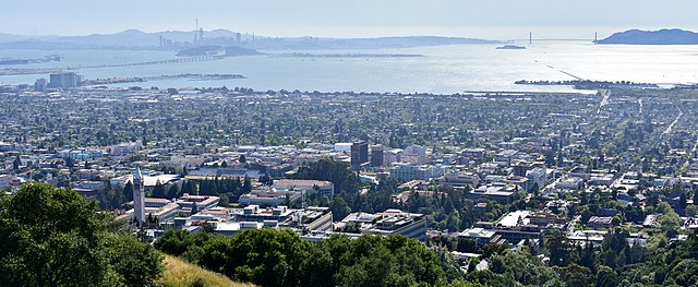
Looking west over the city from the Berkeley Hills, with San Francisco in the background
This pit in the surface of a rock at Indian Rock Park is typical of those used by the Ohlone people to grind acorns.
Berkeley and much of the East Bay was part of Rancho San Antonio, granted to the Peralta family in 1820.
Horses Grazing, Berkeley; painted by artist William Hahn in 1875