Columbia River
Videos
The Columbia River is the largest river in the Pacific Northwest region of North America. The river forms in the Rocky Mountains of British Columbia, Canada. It flows northwest and then south into the U.S. state of Washington, then turns west to form most of the border between Washington and the state of Oregon before emptying into the Pacific Ocean. The river is 1,243 miles long, and its largest tributary is the Snake River. Its drainage basin is roughly the size of France and extends into seven states of the United States and one Canadian province. The fourth-largest river in the United States by volume, the Columbia has the greatest flow of any river entering the Pacific outside of Asia, and the 36th greatest discharge of any river in the world.

Columbia River from Rowena Crest with Interstate 84 on the right

Course of the Columbia River

The Columbia River Gorge facing east toward Beacon Rock
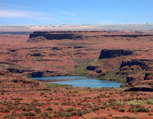
Drumheller Channels, part of the Channeled Scablands formed by the Missoula Floods
Vancouver Expedition
Videos
The Vancouver Expedition (1791–1795) was a four-and-a-half-year voyage of exploration and diplomacy, commanded by Captain George Vancouver of the Royal Navy. The British expedition circumnavigated the globe and made contact with five continents. The expedition at various times included between two and four vessels, and up to 153 men, all but 6 of whom returned home safely.


"Mount Rainier from the south Part of Admiralty Inlet". The mountain was first sighted by Vancouver during his exploration of Puget Sound in the spring of 1792.

The Discovery ran aground in early August 1792 on hidden rocks in Queen Charlotte Strait near Fife Sound. Within a day the Chatham also ran aground on rocks about two miles away.

Friendly Cove, Nootka Sound. Volume I, plate VII from: "A Voyage of Discovery to the North Pacific Ocean and Round the World" by George Vancouver.