Coronado Islands
Videos
The Coronado Islands are a group of islands located 13 km (8 mi) off the northwest coast of the Mexican state of Baja California. Battered by the wind and waves, the rocky islands are mostly uninhabited except for a small military detachment and a lighthouse keeper. Despite their barren appearance, they serve as a refuge for seabirds and support a sizable number of plants, including 6 endemic taxa found only on the islands. The waters around the islands support a considerable amount of diverse marine life.

North Coronado (right background), Central Coronado (left midground), and Pile of Sugar (right midground) viewed from South Coronado (foreground)

South Island contains some of the only structures for the few inhabitants on the islands

At the US-Mexico border. The visible islands are Islas Coronados

The archipelago was first noted by European explorers as "desert islands"
Baja California
Videos
Baja California, officially Estado Libre y Soberano de Baja California, is a state in Mexico. It is the northernmost and westernmost of the 32 federal entities of Mexico. Before becoming a state in 1952, the area was known as the North Territory of Baja California. It has an area of 70,113 km2 (27,071 sq mi) and comprises the northern half of the Baja California Peninsula, north of the 28th parallel, plus oceanic Guadalupe Island. The mainland portion of the state is bordered on the west by the Pacific Ocean; on the east by Sonora, the U.S. state of Arizona, and the Gulf of California; on the north by the U.S. state of California; and on the south by Baja California Sur.
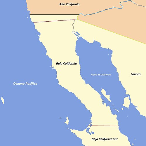
Evolution of the political boundaries of the Californias: Palóu Line (1804–1836) Gila River; border between Las Californias/Alta California and Sonora (1767–1847) Treaty of Guadalupe Hidalgo (1848–Present) Baja California Sur boundary (1931–Present)

Sierra de San Pedro Mártir, with Picacho del Diablo in the center

Encelia californica growing on the Ensenada Municipality coast, typical of the California coastal sage and chaparral ecoregion

Isla Partida, part of the San Lorenzo Marine Archipelago National Park