The Dutch Waterline was a series of water-based defences conceived by Maurice of Nassau in the early 17th century, and realised by his half brother Frederick Henry. Combined with natural bodies of water, the Waterline could be used to transform Holland, the westernmost region of the Netherlands and adjacent to the North Sea, almost into an island. In the 19th century, the Line was extended to include Utrecht.
William III of Orange inspects the Waterline during the Franco-Dutch War
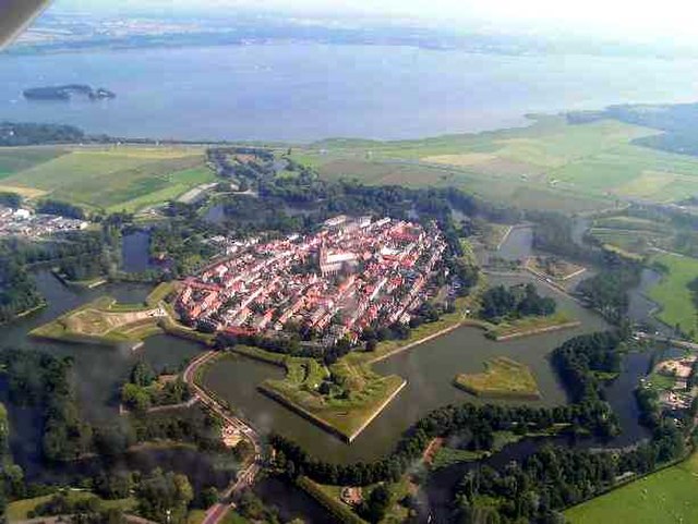
Aerial view of the fortified town of Naarden; with a good view of the star-shaped layout of the earth bastions, designed in the early gunpowder age to place outward guns to force an enemy to keep distance and thus to protect the town proper against shelling
Concrete shelters at Fort Ruigenhoek
Inundation area near fort Ruigenhoek
Utrecht is the fourth-largest city of the Netherlands, as well as the capital and the most populous city of the province of Utrecht. The municipality of Utrecht is located in the eastern part of the Randstad conurbation, in the very centre of mainland Netherlands, and includes Haarzuilens, Vleuten en De Meern. It has a population of 361,699 as of December 2021.
Image: Sol Lumen
Image: Stadhuis Utrecht
Image: Jaarbeursplein Utrecht 2019
Image: Utrecht Uithof, from Cambridge Laan 01