El Niño–Southern Oscillation
El Niño–Southern Oscillation (ENSO) is a global climate phenomenon that emerges from variations in winds and sea surface temperatures over the tropical Pacific Ocean. Those variations have an irregular pattern but do have some semblance of cycles. The occurrence of ENSO is not predictable. It affects the climate of much of the tropics and subtropics, and has links (teleconnections) to higher-latitude regions of the world. The warming phase of the sea surface temperature is known as El Niño and the cooling phase as La Niña. The Southern Oscillation is the accompanying atmospheric component, which is coupled with the sea temperature change. El Niño is associated with higher than normal air sea level pressure over Indonesia, Australia and across the Indian Ocean to the Atlantic. La Niña has roughly the reverse pattern: high pressure over the central and eastern Pacific and lower pressure through much of the rest of the tropics and subtropics. The two phenomena last a year or so each and typically occur every two to seven years with varying intensity, with neutral periods of lower intensity interspersed. El Niño events can be more intense but La Niña events may repeat and last longer.

Sea surface temperature anomalies in November 2007, showing La Niña conditions
Between 50,000 and 100,000 people died during the 2011 East Africa drought.
Image: NOAA Nino
Image: NOAA Nina
Sea surface temperature (SST), or ocean surface temperature, is the ocean temperature close to the surface. The exact meaning of surface varies in the literature and in practice. It is usually between 1 millimetre (0.04 in) and 20 metres (70 ft) below the sea surface. Sea surface temperatures greatly modify air masses in the Earth's atmosphere within a short distance of the shore. Local areas of heavy snow can form in bands downwind of warm water bodies within an otherwise cold air mass. Warm sea surface temperatures can develop and strengthen cyclones over the ocean. Tropical cyclones can also cause a cool wake. This is due to turbulent mixing of the upper 30 metres (100 ft) of the ocean. Sea surface temperature changes during the day. This is like the air above it, but to a lesser degree. There is less variation in sea surface temperature on breezy days than on calm days. The thermohaline circulation has a major impact on average sea surface temperature throughout most of the world's oceans.
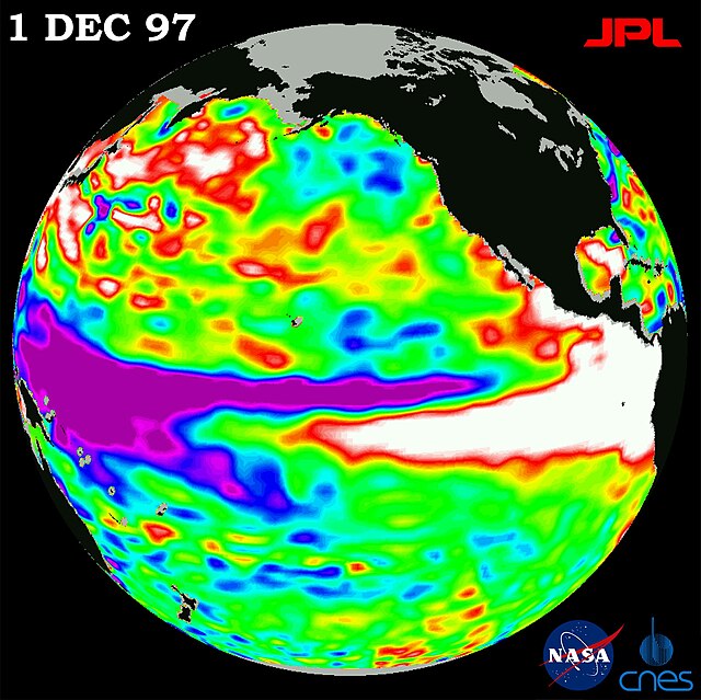
The 1997 El Niño observed by TOPEX/Poseidon. The white areas off the tropical coasts of South and North America indicate the pool of warm water.
Temperature profile of the surface layer of the ocean (a) at night and (b) during the day
Sea-effect snow bands near the Korean Peninsula


