Epirus (Roman province)
Videos
The province of Epirus was a province of the Roman Empire, covering the region of Ancient Epirus. Rome first annexed the region in 167 BC, in the aftermath of the Third Macedonian War, and initially put the region in the larger Roman province of Macedonia, which at the time covered the whole of the Hellenistic world in mainland Europe. In 27 BC, Epirus and Achaea were separated from Macedonia and grouped into the senatorial province of Achaea, with the exception of its northernmost part, which remained part of the province of Macedonia. Under Emperor Trajan, sometime between 103 and 114 AD, Epirus became a separate province, under a procurator Augusti. The new province extended from the Gulf of Aulon (Vlorë) and the Acroceraunian Mountains in the north to the lower course of the Acheloos River in the south, and included the northern Ionian Islands of Corfu, Lefkada, Ithaca, Cephallonia, and Zakynthos.

Ruins of Buthrotum

Roman theatre of Butrint
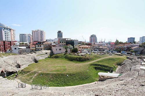
Roman amphitheatre of Dyrrachium

Early Christian basilica, Butrint
Corfu
Videos
Corfu or Kerkyra is a Greek island in the Ionian Sea, of the Ionian Islands, and, including its small satellite islands, forms the margin of the northwestern frontier of Greece. The island is part of the Corfu regional unit, and is administered by three municipalities with the islands of Othonoi, Ereikoussa, and Mathraki. The principal city of the island is also named Corfu. Corfu is home to the Ionian University.


Cape Drastis

Bay of Agios Georgios in northwestern Corfu

Othoni Island