European windstorm
Videos
European windstorms are powerful extratropical cyclones which form as cyclonic windstorms associated with areas of low atmospheric pressure. They can occur throughout the year, but are most frequent between October and March, with peak intensity in the winter months. Deep areas of low pressure are common over the North Atlantic, and occasionally start as nor'easters off the New England coast. They frequently track across the North Atlantic Ocean towards the north of Scotland and into the Norwegian Sea, which generally minimizes the impact to inland areas; however, if the track is further south, it may cause adverse weather conditions across Central Europe, Northern Europe and especially Western Europe. The countries most commonly affected include the United Kingdom, Ireland, the Netherlands, Norway, Germany, the Faroe Islands and Iceland.

2015 list of storm names from UK Met Office and Met Éireann
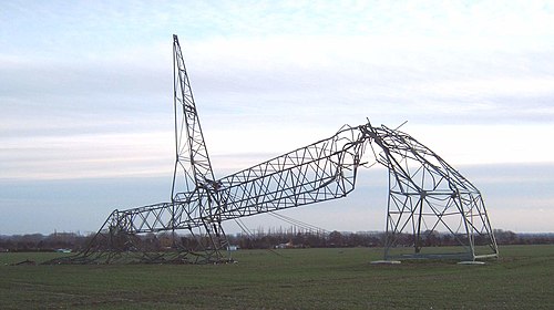
Damaged pylon in Germany after Windstorm Kyrill 2007

Contemporary picture of the flood that struck the North Sea coast of Germany and Denmark in October 1634.
Great storm of 1987
Videos
The great storm of 1987 was a violent extratropical cyclone that occurred on the night of 15–16 October, with hurricane-force winds causing casualties in the United Kingdom, France, and the Channel Islands as a severe depression in the Bay of Biscay moved northeast. Among the most damaged areas were Greater London, Kent, the East Anglian coast, the Home Counties, the west of Brittany, and the Cotentin Peninsula of Normandy, all of which weathered gusts typically with a return period of 1 in 200 years.

The storm at peak intensity over the North Sea

Partially cleared storm damage, Chelmsford

Storm damaged building, Barton on Sea in Hampshire

Storm damage in London