Fort Pitt (Pennsylvania)
Videos
Page
Fort Pitt was a fort built by British forces between 1759 and 1761 during the French and Indian War at the confluence of the Monongahela and Allegheny rivers, where the Ohio River is formed in western Pennsylvania. It was near the site of Fort Duquesne, a French colonial fort built in 1754 as tensions increased between Great Britain and France in both Europe and North America. The French destroyed Fort Duquesne in 1758 when they retreated under British attack.

A Plan of the New Fort at Pitts-Burgh drawn by cartographer John Rocque in 1765

Artist's interpretation of Fort Pitt in 1759 with the Allegheny (left) and Monongahela (right) rivers. At their confluence is the Ohio River, seen at the bottom.
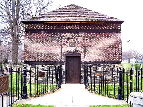
Fort Pitt Blockhouse, constructed in 1764

A view of the Fort Pitt Museum from Mount Washington; its structure is a recreation of a bastion of Ft. Pitt.
Ohio River
Videos
Page
The Ohio River is a 981-mile-long (1,579 km) river in the United States. It is located at the boundary of the Midwestern and Southern United States, flowing in a southwesterly direction from western Pennsylvania to its mouth on the Mississippi River at the southern tip of Illinois. It is the third largest river by discharge volume in the United States and the largest tributary by volume of the north-south flowing Mississippi River, which divides the eastern from western United States. It is also the 6th oldest river on the North American continent. The river flows through or along the border of six states, and its drainage basin includes parts of 14 states. Through its largest tributary, the Tennessee River, the basin includes several states of the southeastern U.S. It is the source of drinking water for five million people.

The widest point on the Ohio River is just north of downtown Louisville, where it is one mile (1.6 km) wide. Indiana is on the right towards the flood gates, Kentucky on the left, towards the locks. The jetty on the left is the entrance to the Louisville and Portland Canal.

Steamboat Morning Star, a Louisville and Evansville mail packet, in 1858

Built between 1847 and 1849, the Wheeling Suspension Bridge was the first bridge across the river and a crucial part of the National Road.

Cave-in-rock, view on the Ohio (circa 1832, Cave-In-Rock, Illinois): aquatint by Karl Bodmer from the book Maximilian, Prince of Wied's Travels in the Interior of North America, during the years 1832–1834