Fort San Carlos was a military structure built in 1816 to defend the Spanish colonial town of Fernandina, Florida, now called Old Town, which occupied a peninsula on the northern end of Amelia Island. The fort, a lunette fortification, stood on the southwest side of the town next to the harbor, on a bluff overlooking the Amelia River. It was made of wood and earthworks, backed with a wooden palisade on the east side, and armed with an eight or ten gun battery. Two blockhouses protected access by land on the south, while the village was surrounded with military pickets. An 1821 map of Fernandina shows that the street plan, laid out in 1811 in a grid pattern by the newly appointed Surveyor General of Spanish East Florida, George J. F. Clarke, today preserves nearly the same layout as that of 1821. The fort occupied the area bounded by the streets Calle de Estrada, Calle de White, and Calle de Someruelos. The structure itself has disappeared and only traces remain in what is now Fernandina Plaza Historic State Park.
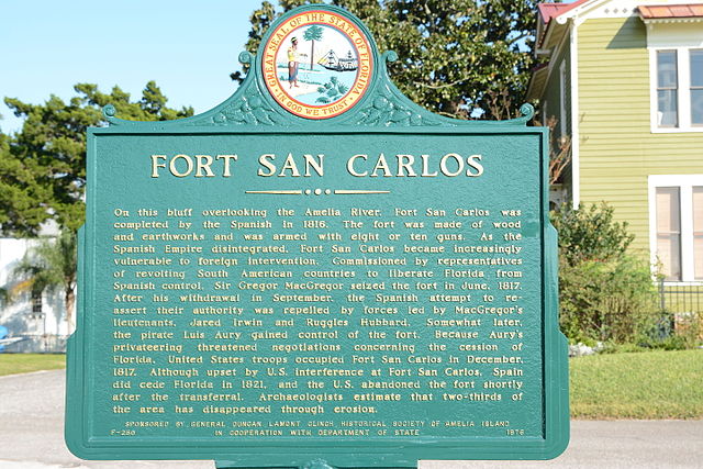
Historical marker
Cannon on the site of the fort
Plan of Amelia Island. 1770 (1777)
Amelia River, viewed from Old Town site
Original Town of Fernandina Historic Site
The Original Town of Fernandina Historic Site, also known as "Old Town", is a historic site in Fernandina Beach, Florida, located on Amelia Island. It is roughly bounded by Towngate Street, Bosque Bello Cemetery, Nassau, Marine, and Ladies Streets. On January 29, 1990, it was added to the U.S. National Register of Historic Places as a historic site. Lying north of the Fernandina Beach Historic District, it is accessible from North 14th Street.
Plaza San Carlos marker at original Fernandina town site
Original site looking toward the Amelia River
Amelia River, viewed from old town of Fernandina site, looking toward St. Marys, Georgia
Plan of Amelia Island. 1770 (1777)


