Geography of Guam
Videos
Page
Guam is a U.S. territory in the western Pacific Ocean, at the boundary of the Philippine Sea. It is the southernmost and largest member of the Mariana Islands archipelago, which is itself the northernmost group of islands in Micronesia. The closest political entity is the Commonwealth of the Northern Mariana Islands (CNMI), another U.S. territory. Guam shares maritime boundaries with CNMI to the north and the Federated States of Micronesia to the south. It is located approximately one quarter of the way from the Philippines to Hawaii. Its location and size make it strategically important. It is the only island with both a protected harbor and land for multiple airports between Asia and Hawaii, on an east–west axis, and between Papua New Guinea and Japan, on a north–south axis.

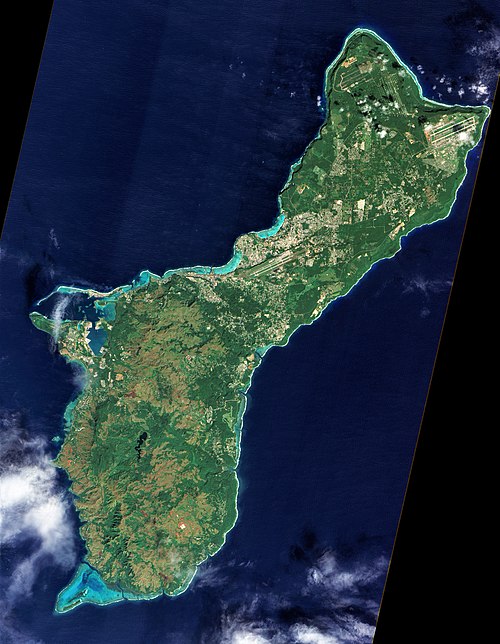
A satellite image of Guam

Two Lovers Point, a National Natural Landmark, is a sea cliff of coralline limestone in northern Guam

About 150 B-52 bombers at Andersen Air Force Base during the 1972 bombings of North Vietnam.

A jungle beach coastline on Guam
Guam
Videos
Page
Guam is an organized, unincorporated territory of the United States in the Micronesia subregion of the western Pacific Ocean. Guam's capital is Hagåtña, and the most populous village is Dededo. It is the westernmost point and territory of the United States, reckoned from the geographic center of the U.S. In Oceania, Guam is the largest and southernmost of the Mariana Islands and the largest island in Micronesia.

Reception of the Manila Galleon by the Chamorro in the Ladrones Islands, c. 1590 Boxer Codex

The main street of Hagåtña c. 1899–1900

U.S. Marines walk through the ruins of Hagåtña, July 1944.
A photograph of Guam from space captured by NASA's now decommissioned Earth observation satellite, Earth Observing-1 (EO-1), December 2011