Giza Plateau
Videos
The Giza Plateau is a limestone plateau in Giza, Egypt, the site of the Fourth Dynasty Giza pyramid complex, which includes the pyramids of Khufu, Khafre and Menkaure, the Great Sphinx, several cemeteries, a workers' village and an industrial complex. It forms the northernmost part of the 16,000 ha Pyramid Fields in the Western Desert edge of the Nile Valley that are part of the UNESCO World Heritage Site, Memphis and its Necropolis.

From north to south: parts of the city of Giza, the Giza Necropolis, and part of the Giza plateau
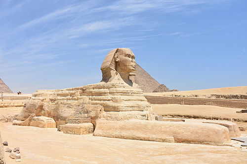
Great Sphinx of Giza

Image: Pyramids of the Giza Necropolis

The Plateau seen from afar in 1955
Fourth Dynasty of Egypt
Videos
The Fourth Dynasty of ancient Egypt is characterized as a "golden age" of the Old Kingdom of Egypt. Dynasty IV lasted from c. 2613 to 2494 BC. It was a time of peace and prosperity as well as one during which trade with other countries is documented.

Sneferu's bent pyramid at Dahshur, an early experiment in true pyramid building

The Red Pyramid of Sneferu, Dahshur. It is Egypt's first successful attempt at constructing a "true" smooth-sided pyramid.

King Khufu built The Great Pyramid of Giza

Giza pyramid complex pyramids. From left to right: the Pyramid of Menkaure, Pyramid of Khafre, the Great Sphinx of Giza and Khufu's Great Pyramid of Giza