Groundwater sapping is a geomorphic erosion process that results in the headward migration of channels in response to near constant fluid discharge at a fixed point. The consistent flow of water displaces fine sediments which physically and chemically weathers rocks. Valleys that appear to have been created by groundwater sapping occur throughout the world in areas such as England, Colorado, Hawai’i, New Zealand, and many other places. However, it is difficult to characterize a landform as being formed exclusively by groundwater sapping due to phenomena such as pluvial runoff, plunge-pool undercutting, changes in water table level, and inconsistent groundwater flow. An example of drainage ways created purely by the outflow of subsurface fluids can be seen on the foreshores of beaches. As the surge of water and sand brought to land by a wave retreats seaward, the film of water becomes thinner until it forms rhomboid shaped patterns in the sand. Small fans form at the apex of the rhombic features, which are eventually fed by the remaining backflow of water traveling downslope. Channels begin to form headward in the form of millimeter wide rills along the sides of the fans; the creation of these small channel networks culminates when the last of the backwash dissipates.
![Scientists believe that groundwater sapping created these gullies in Noachis Terra on Mars.[citation needed] NASA image.](https://upload.wikimedia.org/wikipedia/commons/thumb/4/47/Evidence_for_Recent_Liquid_Water_on_Mars_-_GPN-2000-001434.jpg/400px-Evidence_for_Recent_Liquid_Water_on_Mars_-_GPN-2000-001434.jpg)
Scientists believe that groundwater sapping created these gullies in Noachis Terra on Mars.[citation needed] NASA image.
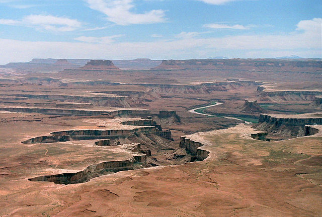
The two canyons at center-left in this photo from Canyonlands National Park in Utah have the theater-shaped heads typical of valley features shaped by groundwater sapping. The Green River is at right.
Valley networks are branching networks of valleys on Mars that superficially resemble terrestrial river drainage basins. They are found mainly incised into the terrain of the martian southern highlands, and are typically - though not always - of Noachian age. The individual valleys are typically less than 5 kilometers wide, though they may extend for up to hundreds or even thousands of kilometers across the martian surface.
Branched valley network in Thaumasia quadrangle, as seen by Viking Orbiter. Field of view is roughly 200 km across.
Part of a valley network near Warrego Valles, seen by THEMIS. Length of image is roughly 50 km.
Finer scale valley networks near Candor Chasma, seen by HiRISE (click to zoom). Field of view is roughly 3.5 km across. Surface the valleys are cut into appears to be eroding back.
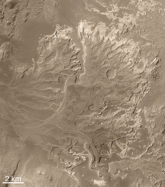
The Eberswalde delta, seen by MGS. Note the meanders with cutoffs, now seen in inverted relief.