Hayward Fault Zone
Videos
The Hayward Fault Zone is a right-lateral strike-slip geologic fault zone capable of generating destructive earthquakes. The fault was first named in the Lawson Report of the 1906 San Francisco Earthquake in recognition of its involvement in the earthquake of 1868. This fault is about 119 km (74 mi) long, situated mainly along the western base of the hills on the east side of San Francisco Bay. It runs through densely populated areas, including Richmond, El Cerrito, Berkeley, Oakland, San Leandro, Castro Valley, Hayward, Union City, Fremont, and San Jose.

Preferential groundwater flow along the fault emerges as a spring supporting the riparian vegetation in the center of this photo of Taylor Mountain Regional Park. The spring is the source of Cooper Creek which flows northward through a deeply incised canyon along the fault on the southern edge of Santa Rosa, California, to a confluence with Matanzas Creek at Doyle Community Park.
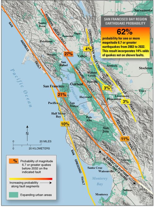
San Francisco Bay region earthquake probability

USGS satellite photo of the San Francisco Bay Area. Light gray areas are heavily urbanized regions

The effects of 15 years of fault creep on a curb in Fremont.
El Cerrito, California
Videos
El Cerrito is a city in Contra Costa County, California, United States, and forms part of the San Francisco Bay Area. It has a population of 25,962 according to the 2020 census. El Cerrito was founded by refugees from the 1906 San Francisco earthquake. It was incorporated in 1917 as a village with 1,500 residents. As of the census in 2022, there were 25,583 people and 10,637 households in the city.

Cerrito Theater on San Pablo Avenue

Don Víctor Castro, a Californio ranchero who helped found El Cerrito on his Rancho El Sobrante.

Albany Hill in neighboring Albany, California, named by Luis María Peralta as "El Cerrito de San Antonio" ("The Little Hill of St. Anthony"), is the namesake of the city.

Shops in El Cerrito.