1.
Counties of Norway
–
Norway is divided into 19 administrative regions, called counties, until 1918, they were known as amter. The counties form the first-level subdivisions of Norway and are divided into 428 municipalities. Svalbard and Jan Mayen are outside the county division and ruled directly on national level, the capital Oslo is considered both a county and a municipality. In 2017 the government decided to abolish the current counties and to them with fewer, larger administrative regions. Below is a list of the Norwegian counties as they have been since 1919, note that the counties are administered both by appointees of the national government and to a lesser extent by their own elected bodies. The county numbers are from the numbering system ISO 3166-2, NO. The number 13 was dropped from the system when the city of Bergen was merged into Hordaland in 1972, from the consolidation to a single kingdom, Norway was divided into a number of geographic regions that had its own legislative assembly or Thing, such as Gulating and Frostating. The second-order subdivision of these regions was into fylker, such as Egdafylke and Hordafylke, in 1914, the historical term fylke was brought into use again to replace the term amt introduced during the union with Denmark. Current day counties often, but not necessarily, correspond to the historical areas. Finnmark, the Faroe Islands, the Orkney Islands, Shetland, the Hebrides, Isle of Man, Iceland and Greenland were Norwegian skattland, from the end of the 12th century, Norway was divided into several syssel. The head of the various syssel was the syslemann, who represented the king locally, the following shows a reconstruction of the different syssel in Norway c. 1300, including sub-syssel where these seem established, from 1308, the term len in Norway signified an administrative region roughly equivalent to todays counties. The historic len was an important administrative entity during the period of Dano-Norwegian unification after their amalgamation as one state, which lasted for the period 1536–1814. At the beginning of the 16th century the political divisions were variable, up to 1660 the four principal len were headquartered at the major fortresses Bohus Fortress, Akershus Fortress, Bergenhus Fortress and the fortified city of Trondheim. The sub-regions corresponded to the districts for the Lutheran church in Norway. Båhus len Akershus len Trondheim len Bergenhus len These four principal len were in the 1530s divided into approximately 30 smaller regions. From that point forward through the beginning of the 17th century the number of subsidiary len was reduced, from 1660 Norway had nine principal len comprising 17 subsidiary len, Len written as län continues to be used as the administrative equivalent of county in Sweden to this day. Each len was governed by a lenman, with the royal decree of February 19,1662, each len was designated an amt and the lenmann was titled amtmann, from German Amt, reflecting the bias of the Danish court of that period
2.
Rondane National Park
–
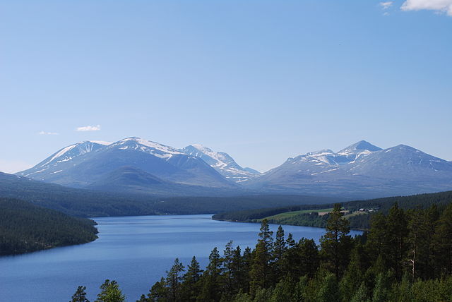
Rondane National Park is the oldest national park in Norway, established on 21 December 1962. The park contains ten peaks above 2,000 metres, with the highest being Rondeslottet at an altitude of 2,178 m, the park is an important habitat for herds of wild reindeer. The park was extended in 2003, and now covers an area of 963 km2 in the counties Oppland, Rondane lies just to the east of Gudbrandsdal and two other mountain areas, Dovre and Jotunheimen are nearby. Rondane is a high mountain area, with large plateaus. The highest point is Rondeslottet at an altitude of 2,178 m, the lowest point is just below the tree line, which is approximately 1,000 to 1,100 m above sea level. The climate is mild but relatively arid, apart from the White Birch trees of the lower areas, the soil and rocks are covered by heather and lichen, since they lack nutrients. The largest mountains are almost entirely barren, above 1,500 m nothing, the central massif is also cut by botns, flat, dead stone valleys below the steep mountain walls of the peaks. Generally, Rondane does not receive enough precipitation to generate persistent glaciers, the centre of the Park is the Rondvatnet lake, from which all the peaks beyond 2,000 m of altitude can be reached in less than one days walk. In this central region and north of it, the altitude is high compared with the flatter plateaus of the south. Rondane has ten peaks over 2,000 m, Rondeslottet, Storronden, Høgronden, Midtronden western summit, Vinjeronden, Midtronden eastern summit, Trolltinden, Storsmeden, Digerronden, and Veslesmeden. In many parts of the park, there are spread-out holes created by small remains of ice age glaciers, the history of life in the area of the park begins at the end of the latest ice age. Large climate changes allowed reindeer to spread widely across Scandinavia, only to be forced back to a smaller area — including the Rondane mountain area — only some hundreds of years later. Archaeologists have found that the forest quickly grew at high altitudes, on the mountain plateaux, there is evidence that nomadic hunter-gatherers lived off reindeer. Large traps used to catch reindeer can be found at Gravhø and these are constructed from stone to make holes or large fenced-in areas into which reindeer could be tricked or led. In conjunction with large traps, there are also small arched stone walls which are believed to have been used as hiding places for archers waiting for prey. Various dating methods have suggested that the earliest traps may be as old as 3500 years, most of the findings, including remains of houses, date back to the years between 500 and 700 AD. It is thus known with confidence that the traps and accompanying walls were used from the 6th century until the onset of the Black Death in the 14th century. After nearly a decade of planning, Rondane was established as the first Norwegian National Park on 21 December 1962 and it was first established as a nature protection area, but was later named a national park
3.
Norway
–
The Antarctic Peter I Island and the sub-Antarctic Bouvet Island are dependent territories and thus not considered part of the Kingdom. Norway also lays claim to a section of Antarctica known as Queen Maud Land, until 1814, the kingdom included the Faroe Islands, Greenland, and Iceland. It also included Isle of Man until 1266, Shetland and Orkney until 1468, Norway has a total area of 385,252 square kilometres and a population of 5,258,317. The country shares a long border with Sweden. Norway is bordered by Finland and Russia to the north-east, Norway has an extensive coastline, facing the North Atlantic Ocean and the Barents Sea. King Harald V of the Dano-German House of Glücksburg is the current King of Norway, erna Solberg became Prime Minister in 2013, replacing Jens Stoltenberg. A constitutional monarchy, Norway divides state power between the Parliament, the Cabinet and the Supreme Court, as determined by the 1814 Constitution, the kingdom is established as a merger of several petty kingdoms. By the traditional count from the year 872, the kingdom has existed continuously for 1,144 years, Norway has both administrative and political subdivisions on two levels, counties and municipalities. The Sámi people have an amount of self-determination and influence over traditional territories through the Sámi Parliament. Norway maintains close ties with the European Union and the United States, the country maintains a combination of market economy and a Nordic welfare model with universal health care and a comprehensive social security system. Norway has extensive reserves of petroleum, natural gas, minerals, lumber, seafood, the petroleum industry accounts for around a quarter of the countrys gross domestic product. On a per-capita basis, Norway is the worlds largest producer of oil, the country has the fourth-highest per capita income in the world on the World Bank and IMF lists. On the CIAs GDP per capita list which includes territories and some regions, from 2001 to 2006, and then again from 2009 to 2017, Norway had the highest Human Development Index ranking in the world. It also has the highest inequality-adjusted ranking, Norway ranks first on the World Happiness Report, the OECD Better Life Index, the Index of Public Integrity and the Democracy Index. Norway has two names, Noreg in Nynorsk and Norge in Bokmål. The name Norway comes from the Old English word Norðrveg mentioned in 880, meaning way or way leading to the north. In contrasting with suðrvegar southern way for Germany, and austrvegr eastern way for the Baltic, the Anglo-Saxon of Britain also referred to the kingdom of Norway in 880 as Norðmanna land. This was the area of Harald Fairhair, the first king of Norway, and because of him
4.
Eastern Norway
–
Eastern Norway is the geographical region of the south-eastern part of Norway. It consists of the counties Telemark, Vestfold, Østfold, Akershus, Oslo, Buskerud, Oppland, eastern Norway is by far the most populous region of Norway. It contains the capital, Oslo, which is Norways most populous city. In Norwegian, the region is called Østlandet and Austlandet in contrast to Vestlandet, as of 2010, the region had 2,454,700 inhabitants. In 2014, Norways population was 5,156,450, the region is bounded by mountains in the north and west, the Swedish border to the east and by Viken and Skagerrak to the south. The border towards Sørlandet is less obvious, the mountains reach a height of 2469 metres in the Jotunheimen mountain range, the highest point in the Nordic countries. Other prominent mountain ranges include part of the Dovrefjell in the far north of the region, the high plateau of Hardangervidda extends into Western Norway. Valleys cut deep into the mountains, from east to west the valleys are Østerdal, Gudbrandsdal, Valdres, Hallingdal, Numedal. Østerdalen is surrounded by mostly flat areas of forests. The population density in the flatlands is the highest in the nation, numerous islands shelter the coasts, creating a paradise for swimmers and boaters in the summer. The Norwegian dialects spoken in the south-east share a common intonation, the dialects of the interior mountainous areas are all distinct. The dialects of the areas are more similar to the written language. The eastern forests of Finnskogen were the home of an ethnic minority and their language and culture was preserved into the 20th century, but now only folk tunes and food specialities remain. The southernmost group of Norways Sami population is to be found in the north-eastern corner, the culture of mountain valleys is preserved to a greater degree than the more urbanized metropolitan areas. The area is distinguished with traditional architecture, like churches and lafting, folk music. Some are concerned for the loss of culture in the face of modernization. It is common to see moose warning signs missing from their posts and this is of course illegal, and can result in a fine. The coastal region is populated both by Norwegian and European standards
5.
Hamar
–
Hamar is a town and municipality in Hedmark county, Norway. It is part of the region of Hedmarken. The administrative centre of the municipality is the town of Hamar, the municipality of Hamar was separated from Vang as a town and municipality of its own in 1849. Vang was merged back into Hamar on 1 January 1992, the town is located on the shores of Mjøsa, Norways largest lake, and is the principal city of Hedmark county. It is bordered to the northwest by the municipality of Ringsaker, to the north by Åmot, to the east by Løten, the municipality is named after the old Hamar farm, since the medieval town was built on its ground. The name is identical with the word hamarr which means rocky hill, the coat-of-arms shows a Black Grouse sitting in the top of a pine tree on a white background. It was first described in the anonymous Hamarkrøniken written in 1553, between 500 and 1000 AD, Aker farm was one of the most important power centres in Norway, located just a few kilometres away from todays Hamar. Three coins found in Ringerike in 1895 have been dated to the time of Harald Hardråde and are inscribed Olafr a Hamri. At some point, presumably after 1030 but clearly before 1152, there are some indications Harald Hardråde initiated this move because he had property at the new site. Much of the information about medieval Hamar is derived from the Hamar Chronicles, the town is said to have reached its apex in the early 14th century, dominated by the Hamar cathedral, bishops manor, and fortress, and surrounding urbanization. The town was known for its fragrant apple orchards, but there were also merchants, craftsmen and this diocese included Hedemarken and Christians Amt, being separated in 1152 from the former diocese of Oslo. The first bishop of Hamar was Arnold, Bishop of Gardar and he began to build the now ruined cathedral of Christ Church, which was completed about the time of Bishop Paul. Bishop Thorfinn was exiled and died at Ter Doest abbey in Flanders, Bishop Jörund was transferred to Trondheim. A provincial council was held in 1380, there were at Hamar a cathedral chapter with ten canons, a school, a Dominican Priory of St. Olaf, and a monastery of the Canons Regular of St. Anthony of Vienne. Hamar, like most of Norway, was diminished by the Black Plague in 1349. The Reformation in Norway took less than 10 years to complete, the fortress was made into the residence of the sheriff and renamed Hamarhus fortress. By 1587, merchants in Oslo had succeeded in moving all of Hamars market activities to Oslo, though some regional and seasonal trade persisted into the 17th century, Hamar as a town ceased to exist by then. In its place, the area was used for agriculture under the farm of Storhamar, though the ruins of the cathedral, fortress, and lesser buildings became landmarks for centuries since then
6.
County governor (Norway)
–
County Governor is a Norwegian government agency represented in 17 of the Norwegian counties responsible for a number of supervision and management duties. The Governor is the representative of the King and Government of Norway in each county, the County Governors are subordinate to the Ministry of Government Administration and Reform, but are also subordinate to other ministries in their respective duties. Governors are parts of the branch and thus formally appointed by the King in the cabinet meeting. The Governor is also responsible for matters including marriage, divorce. If a municipality do not have an economy, the Governor will enter the municipality into the ROBEK registry. The Governor of Svalbard has wider authorities, including the police authority, the County Governor has been an institution since the 12th century, though the institution has had many names, including sysselmann, lensmann, amtmann and now fylkesmann. Its present form was created in 1976 when the county municipality was demerged to form a separate, most governors are former politicians or have a background in the police force. It is uncommon for governors to hold an office for less than a decade, although almost all County Governors are former active politicians, it has been regarded as customary that an incumbent County Governor does not participate in partisan politics
7.
Labour Party (Norway)
–
The Labour Party, formerly the Norwegian Labour Party, is a social-democratic political party in Norway. It was formerly the senior partner of the governing Red-Green Coalition, the party is currently led by Jonas Gahr Støre. The Labour Party is officially committed to social-democratic ideals and its slogan since the 1930s has been everyone shall take part, and the party traditionally seeks a strong welfare state, funded through taxes and duties. During the first Stoltenberg government, the policies were inspired by Tony Blairs New Labour. The party has frequently described as increasingly neoliberal since the 1980s. The Labour Party profiles itself as a party that subscribes to cooperation on a national as well as international level. Its youth wing is the Workers Youth League, the party is a full member of the Party of European Socialists and Progressive Alliance, and is an observer member of the Socialist International. The Labour Party has always been a supporter of Norways NATO membership and has supported Norwegian membership in the European Union during two referendums. Founded in 1887, the party increased in support until it became the largest party in Norway in 1927. This year also saw the consolidation of surrounding the party during the 1920s following its membership in the Comintern from 1919 to 1923. It formed its first government in 1928, and has led the government for all but 16 years since 1935, from 1945 to 1961, the party had an absolute majority in the Norwegian parliament, the only time this has ever happened in Norwegian history. The domination by the Labour Party, during the 1960s and early 1970s, was broken by competition from the left. From the end of the 1970s however, the party started to lose voters to the right, in 2001 the party achieved its worst electoral results since 1924. Between 2005 and 2013, Labour returned to power after committing to an agreement with other parties in order to form a majority government. Since losing 9 seats in the 2013 election, Labour has been in opposition, the party was founded in 1887 in Arendal and first ran in elections to the Parliament of Norway in 1894. It entered Parliament in 1904 after the 1903 election, and steadily increased its vote until 1927, the party were members of Comintern, a Communist organisation, between 1918 and 1923. From the establishment of Vort Arbeide in 1884, the party had a growing and notable organisation of newspapers, the party press system eventually resulted in Norsk Arbeiderpresse. In January 1913 the party had 24 newspapers, and 6 more newspapers were founded in 1913, the party also had the periodical Det 20de Aarhundre
8.
Centre Party (Norway)
–
The Centre Party is an agrarian centrist political party in Norway. From its founding until 2000, the party joined only governments not led by the Labour Party, governments headed by prime ministers from the party include the short-lived Kolstad and Hundseids Cabinet between 1931 and 1933, and the longer-lasting Bortens Cabinet from 1965 until 1971. The party was founded at the convention of the Norsk Landmandsforbund during 17 to 19 June 1920. In 1922 the association was renamed to the Norwegian Agrarian Association, during the eight decades since the Centre Party was created as a political faction of a Norwegian agrarian organisation, the party has changed a great deal. The 1930s have in the post-war era been seen as a time in the partys history. This is partly because Vidkun Quisling, who became leader of Nasjonal Samling, was Minister of Defence in the Farmers Party Kolstad. Quisling was however not a member of the Farmers Party, while there were fascist sympaties among parts of the Farmers Partys electorate, the Farmers Party itself never supported fascism. It was after all the Farmers Party that enabled the first stable Labour cabinet in Norway, in 1935, they reached a compromise with the Labour Party, which led to the Nygaardsvold Cabinet. In addition, the Farmers Party was represented in the cabinet by Anders Fjeldstad. Political scientist Trond Nordby in 2009 also said that the Farmers Party has been given a bad reputation from this time. In 1959 the party changed their name to the Norwegian Democratic Party — Democrats, in June 1959 the name was changed to the current Centre Party. This happened out of the need to attract an additional electorate with the decline of the agrarian share of the population. The partys membership peaked at 70,000 in 1971. In local elections, the party enjoys strong support in small municipalities. After the 2007 elections,83 of the mayors in Norway represent the Centre Party, only the Labour Party has more mayors, and relative to party size, the Centre Party has more mayors than any other. The Centre Party had been a part of only non-socialist coalition governments from 1930 to 2000, in seven governments and these negotiations succeeded and the Centre Party entered the Second Stoltenberg Cabinet on 17 October 2005 with four ministers. The Red-Greens were re-elected to government in the 2009 election and it has been argued that the partys ideology has moved more towards social democracy in recent years. This included increased duties of 429% on lamb, 344% on beef, the party is known in Norway for their support of high toll tariffs on foreign cheese and meat, called toll protection, and their proposal to shoot all wolves in Norway
9.
Demonym
–
A demonym is a word that identifies residents or natives of a particular place, which is derived from the name of that particular place. It is a neologism, previously gentilic was recorded in English dictionaries, e. g. the Oxford English Dictionary, thus a Thai may be any resident or citizen of Thailand, of any ethnic group, or more narrowly a member of the Thai people. Conversely, some groups of people may be associated with multiple demonyms, for example, a native of the United Kingdom may be called a British person, a Brit, or a Briton. In some languages, when a parallel demonym does not exist, in English, demonyms are capitalized and are often the same as the adjectival form of the place, e. g. Egyptian, Japanese, or Greek. Significant exceptions exist, for instance the adjectival form of Spain is Spanish, English widely includes country-level demonyms such as Ethiopian or Guatemalan and more local demonyms such as Seoulite, Wisconsinite, Chicagoan, Michigander, Fluminense, and Paulista. Some places lack a commonly used and accepted demonym and this poses a particular challenge to those toponymists who research demonyms. The word gentilic comes from the Latin gentilis and the English suffix -ic, the word demonym was derived from the Greek word meaning populace with the suffix for name. National Geographic attributes the term demonym to Merriam-Webster editor Paul Dickson in a recent work from 1990 and it was subsequently popularized in this sense in 1997 by Dickson in his book Labels for Locals. However, in What Do You Call a Person From, a Dictionary of Resident Names attributed the term to George H. Scheetz, in his Names Names, A Descriptive and Prescriptive Onymicon, which is apparently where the term first appears. Several linguistic elements are used to create demonyms in the English language, the most common is to add a suffix to the end of the location name, slightly modified in some instances. Cairo → Cairene Cyrenaica → Cyrene Damascus → Damascene Greece → Greek Nazareth → Nazarene Slovenia → Slovene Often used for Middle Eastern locations and European locations. Kingston-upon-Hull → Hullensian Leeds → Leodensian Spain → Spaniard Savoy → Savoyard -ese is usually considered proper only as an adjective, thus, a Chinese person is used rather than a Chinese. Monaco → Monégasque Menton → Mentonasque Basque Country → Basque Often used for French locations, mostly they are from Africa and the Pacific, and are not generally known or used outside the country concerned. In much of East Africa, a person of an ethnic group will be denoted by a prefix. For example, a person of the Luba people would be a Muluba, the plural form Baluba, similar patterns with minor variations in the prefixes exist throughout on a tribal level. And Fijians who are indigenous Fijians are known as Kaiviti and these demonyms are usually more informal and colloquial. In the United States such informal demonyms frequently become associated with mascots of the sports teams of the state university system. In other countries the origins are often disputed and these will typically be formed using the standard models above
10.
Daylight saving time
–
Daylight saving time is the practice of advancing clocks during summer months by one hour so that evening daylight lasts an hour longer, while sacrificing normal sunrise times. Typically, regions that use Daylight Savings Time adjust clocks forward one hour close to the start of spring, American inventor and politician Benjamin Franklin proposed a form of daylight time in 1784. New Zealander George Hudson proposed the idea of saving in 1895. The German Empire and Austria-Hungary organized the first nationwide implementation, starting on April 30,1916, many countries have used it at various times since then, particularly since the energy crisis of the 1970s. The practice has both advocates and critics, DST clock shifts sometimes complicate timekeeping and can disrupt travel, billing, record keeping, medical devices, heavy equipment, and sleep patterns. Computer software often adjusts clocks automatically, but policy changes by various jurisdictions of DST dates, industrialized societies generally follow a clock-based schedule for daily activities that do not change throughout the course of the year. The time of day that individuals begin and end work or school, North and south of the tropics daylight lasts longer in summer and shorter in winter, with the effect becoming greater as one moves away from the tropics. However, they will have one hour of daylight at the start of each day. Supporters have also argued that DST decreases energy consumption by reducing the need for lighting and heating, DST is also of little use for locations near the equator, because these regions see only a small variation in daylight in the course of the year. After ancient times, equal-length civil hours eventually supplanted unequal, so civil time no longer varies by season, unequal hours are still used in a few traditional settings, such as some monasteries of Mount Athos and all Jewish ceremonies. This 1784 satire proposed taxing window shutters, rationing candles, and waking the public by ringing church bells, despite common misconception, Franklin did not actually propose DST, 18th-century Europe did not even keep precise schedules. However, this changed as rail transport and communication networks came to require a standardization of time unknown in Franklins day. Modern DST was first proposed by the New Zealand entomologist George Hudson, whose shift work job gave him time to collect insects. An avid golfer, he also disliked cutting short his round at dusk and his solution was to advance the clock during the summer months, a proposal he published two years later. The proposal was taken up by the Liberal Member of Parliament Robert Pearce, a select committee was set up to examine the issue, but Pearces bill did not become law, and several other bills failed in the following years. Willett lobbied for the proposal in the UK until his death in 1915, william Sword Frost, mayor of Orillia, Ontario, introduced daylight saving time in the municipality during his tenure from 1911 to 1912. Starting on April 30,1916, the German Empire and its World War I ally Austria-Hungary were the first to use DST as a way to conserve coal during wartime, Britain, most of its allies, and many European neutrals soon followed suit. Russia and a few other countries waited until the year
11.
Central European Summer Time
–
It corresponds to UTC + two hours. Other names which have been applied to Central European Summer Time are Middle European Summer Time, Central European Daylight Saving Time, and Bravo Time. Since 1996 European Summer Time has been observed between 1,00 UTC on the last Sunday of March and 1,00 on the last Sunday of October, the following countries and territories use Central European Summer Time. In addition, Libya used CEST during the years 1951–1959, 1982–1989, 1996–1997, European Summer Time Other countries and territories in UTC+2 time zone Other names of UTC+2 time zone
12.
Norwegian language
–
Norwegian is a North Germanic language spoken mainly in Norway, where it is the official language. Along with Swedish and Danish, Norwegian forms a continuum of more or less mutually intelligible local and regional variants. These Scandinavian languages, together with Faroese and Icelandic as well as extinct languages. Faroese and Icelandic are hardly mutually intelligible with Norwegian in their spoken form because continental Scandinavian has diverged from them, as established by law and governmental policy, the two official forms of written Norwegian are Bokmål and Nynorsk. The official Norwegian Language Council is responsible for regulating the two forms, and recommends the terms Norwegian Bokmål and Norwegian Nynorsk in English. Two other written forms without official status also exist, one and it is regulated by the unofficial Norwegian Academy, which translates the name as Standard Norwegian. Nynorsk and Bokmål provide standards for how to write Norwegian, no standard of spoken Norwegian is officially sanctioned, and most Norwegians speak their own dialects in all circumstances. Thus, unlike in other countries, the use of any Norwegian dialect. Outside Eastern Norway, this variation is not used. From the 16th to the 19th centuries, Danish was the written language of Norway. As a result, the development of modern written Norwegian has been subject to strong controversy related to nationalism, rural versus urban discourse, historically, Bokmål is a Norwegianised variety of Danish, while Nynorsk is a language form based on Norwegian dialects and puristic opposition to Danish. The unofficial form known as Riksmål is considered more conservative than Bokmål, Norwegians are educated in both Bokmål and Nynorsk. A2005 poll indicates that 86. 3% use primarily Bokmål as their written language,5. 5% use both Bokmål and Nynorsk, and 7. 5% use primarily Nynorsk. Thus, 13% are frequently writing Nynorsk, though the majority speak dialects that resemble Nynorsk more closely than Bokmål. Broadly speaking, Nynorsk writing is widespread in western Norway, though not in major urban areas, examples are Setesdal, the western part of Telemark county and several municipalities in Hallingdal, Valdres, and Gudbrandsdalen. It is little used elsewhere, but 30–40 years ago, it also had strongholds in rural parts of Trøndelag. Today, not only is Nynorsk the official language of four of the 19 Norwegian counties, NRK, the Norwegian broadcasting corporation, broadcasts in both Bokmål and Nynorsk, and all governmental agencies are required to support both written languages. Bokmål is used in 92% of all publications, and Nynorsk in 8%
13.
Norwegian krone
–
The krone, plural kroner, is the currency of Norway and its dependent territories. It is subdivided into 100 øre, which exist only electronically since 2012, the name translates into English as crown. The krone was the thirteenth most traded currency in the world by value in April 2010, the krone was introduced in 1875, replacing the Norwegian speciedaler/spesidaler at a rate of 4 kroner =1 speciedaler. In doing so, Norway joined the Scandinavian Monetary Union, which had established in 1873. After its dissolution, Denmark, Norway, and Sweden all decided to keep the names of their respective, within the Scandinavian Monetary Union, the krone was on a gold standard of 2,480 kroner =1 kilogram of pure gold. This gold standard was restored between 1916 and 1920 and again in 1928 and it was suspended permanently in 1931, when a peg to the British pound of 19.9 kroner =1 pound was established. In 1939, Norway pegged the krone temporarily to the U. S. dollar at a rate of 4.4 kroner =1 dollar, nonetheless, Norway would continue to hold the Kingdoms gold reserves. During the German occupation in the Second World War, the krone was initially pegged to the Reichsmark at a rate of 1 krone =0.6 Reichsmark, after the war, a rate of 20 kroner =1 pound was established. The rate to the pound was maintained in 1949, when the pound devalued relative to the U. S. dollar, in 1875, coins were introduced in denominations of 10 and 50 øre and 1 and 10 kroner. These coins also bore the denomination in the currency, as 3,15. Between 1875 and 1878, the new coinage was introduced in full, in denominations of 1,2,5,10,25, and 50 øre and 1,2, and 10 kroner. The 1,2, and 5 øre were struck in bronze, the 10,25, and 50 øre and 1 and 2 kroner, in silver, the last gold coins were issued in 1910, silver was replaced by cupro-nickel from 1920. Between 1917 and 1921, iron replaced bronze. 1917 also saw the last issuance of 2 kroner coins, during the German occupation in the Second World War, zinc was used in place of cupro-nickel in 10,25, and 50 øre coins, and production of the 1 krone piece was suspended. In 1963,5 kroner coins were introduced, production of 1 and 2 øre coins ceased in 1972. The following year, the size of the 5 øre coin was reduced, production of the denomination ceased in 1982, ten-kroner coins were introduced in 1983. In 1992, the last 10 øre coins were minted, between 1994 and 1998, a new coinage was introduced, consisting of 50 øre,1,5,10, and 20 kroner. These are the coins which are currently legal tender, with the exception of the 50-øre coin which was withdrawn on 1 May 2012
14.
Gross domestic product
–
Gross Domestic Product is a monetary measure of the market value of all final goods and services produced in a period. Nominal GDP estimates are used to determine the economic performance of a whole country or region. The OECD defines GDP as a measure of production equal to the sum of the gross values added of all resident and institutional units engaged in production. ”An IMF publication states that GDP measures the monetary value of final goods and services - that is. Total GDP can also be broken down into the contribution of industry or sector of the economy. The ratio of GDP to the population of the region is the per capita GDP. William Petty came up with a concept of GDP to defend landlords against unfair taxation during warfare between the Dutch and the English between 1652 and 1674. Charles Davenant developed the method further in 1695, the modern concept of GDP was first developed by Simon Kuznets for a US Congress report in 1934. In this report, Kuznets warned against its use as a measure of welfare, after the Bretton Woods conference in 1944, GDP became the main tool for measuring a countrys economy. The switch from GNP to GDP in the US was in 1991, the history of the concept of GDP should be distinguished from the history of changes in ways of estimating it. The value added by firms is relatively easy to calculate from their accounts, but the value added by the sector, by financial industries. GDP can be determined in three ways, all of which should, in principle, give the same result and they are the production approach, the income approach, or the expenditure approach. The most direct of the three is the approach, which sums the outputs of every class of enterprise to arrive at the total. The income approach works on the principle that the incomes of the factors must be equal to the value of their product. This approach mirrors the OECD definition given above, deduct intermediate consumption from gross value to obtain the gross value added. Gross value added = gross value of output – value of intermediate consumption, value of output = value of the total sales of goods and services plus value of changes in the inventories. The sum of the value added in the various economic activities is known as GDP at factor cost. GDP at factor cost plus indirect taxes less subsidies on products = GDP at producer price, for measuring output of domestic product, economic activities are classified into various sectors. Subtracting each sectors intermediate consumption from gross output gives the GDP at factor cost, adding indirect tax minus subsidies in GDP at factor cost gives the GDP at producer prices
15.
Christianity
–
Christianity is a Abrahamic monotheistic religion based on the life and teachings of Jesus Christ, who serves as the focal point for the religion. It is the worlds largest religion, with over 2.4 billion followers, or 33% of the global population, Christians believe that Jesus is the Son of God and the savior of humanity whose coming as the Messiah was prophesied in the Old Testament. Christian theology is summarized in creeds such as the Apostles Creed and his incarnation, earthly ministry, crucifixion, and resurrection are often referred to as the gospel, meaning good news. The term gospel also refers to accounts of Jesuss life and teaching, four of which—Matthew, Mark, Luke. Christianity is an Abrahamic religion that began as a Second Temple Judaic sect in the mid-1st century, following the Age of Discovery, Christianity spread to the Americas, Australasia, sub-Saharan Africa, and the rest of the world through missionary work and colonization. Christianity has played a prominent role in the shaping of Western civilization, throughout its history, Christianity has weathered schisms and theological disputes that have resulted in many distinct churches and denominations. Worldwide, the three largest branches of Christianity are the Catholic Church, the Eastern Orthodox Church, and the denominations of Protestantism. There are many important differences of interpretation and opinion of the Bible, concise doctrinal statements or confessions of religious beliefs are known as creeds. They began as baptismal formulae and were expanded during the Christological controversies of the 4th and 5th centuries to become statements of faith. Many evangelical Protestants reject creeds as definitive statements of faith, even agreeing with some or all of the substance of the creeds. The Baptists have been non-creedal in that they have not sought to establish binding authoritative confessions of faith on one another. Also rejecting creeds are groups with roots in the Restoration Movement, such as the Christian Church, the Evangelical Christian Church in Canada, the Apostles Creed is the most widely accepted statement of the articles of Christian faith. It is also used by Presbyterians, Methodists, and Congregationalists and this particular creed was developed between the 2nd and 9th centuries. Its central doctrines are those of the Trinity and God the Creator, each of the doctrines found in this creed can be traced to statements current in the apostolic period. The creed was used as a summary of Christian doctrine for baptismal candidates in the churches of Rome. Most Christians accept the use of creeds, and subscribe to at least one of the mentioned above. The central tenet of Christianity is the belief in Jesus as the Son of God, Christians believe that Jesus, as the Messiah, was anointed by God as savior of humanity, and hold that Jesus coming was the fulfillment of messianic prophecies of the Old Testament. The Christian concept of the Messiah differs significantly from the contemporary Jewish concept, Jesus, having become fully human, suffered the pains and temptations of a mortal man, but did not sin
16.
Islam
–
Islam is an Abrahamic monotheistic religion which professes that there is only one and incomparable God and that Muhammad is the last messenger of God. It is the worlds second-largest religion and the major religion in the world, with over 1.7 billion followers or 23% of the global population. Islam teaches that God is merciful, all-powerful, and unique, and He has guided mankind through revealed scriptures, natural signs, and a line of prophets sealed by Muhammad. The primary scriptures of Islam are the Quran, viewed by Muslims as the word of God. Muslims believe that Islam is the original, complete and universal version of a faith that was revealed many times before through prophets including Adam, Noah, Abraham, Moses. As for the Quran, Muslims consider it to be the unaltered, certain religious rites and customs are observed by the Muslims in their family and social life, while social responsibilities to parents, relatives, and neighbors have also been defined. Besides, the Quran and the sunnah of Muhammad prescribe a comprehensive body of moral guidelines for Muslims to be followed in their personal, social, political, Islam began in the early 7th century. Originating in Mecca, it spread in the Arabian Peninsula. The expansion of the Muslim world involved various caliphates and empires, traders, most Muslims are of one of two denominations, Sunni or Shia. Islam is the dominant religion in the Middle East, North Africa, sizable Muslim communities are also found in Horn of Africa, Europe, China, Russia, Mainland Southeast Asia, Philippines, Northern Borneo, Caucasus and the Americas. Converts and immigrant communities are found in almost every part of the world, Islam is a verbal noun originating from the triliteral root s-l-m which forms a large class of words mostly relating to concepts of wholeness, submission, safeness and peace. In a religious context it means voluntary submission to God, Islām is the verbal noun of Form IV of the root, and means submission or surrender. Muslim, the word for an adherent of Islam, is the active participle of the verb form. The word sometimes has connotations in its various occurrences in the Quran. In some verses, there is stress on the quality of Islam as a state, Whomsoever God desires to guide. Other verses connect Islām and dīn, Today, I have perfected your religion for you, I have completed My blessing upon you, still others describe Islam as an action of returning to God—more than just a verbal affirmation of faith. In the Hadith of Gabriel, islām is presented as one part of a triad that also includes imān, Islam was historically called Muhammadanism in Anglophone societies. This term has fallen out of use and is said to be offensive because it suggests that a human being rather than God is central to Muslims religion
17.
Buddhism
–
Buddhism is a religion and dharma that encompasses a variety of traditions, beliefs and spiritual practices largely based on teachings attributed to the Buddha. Buddhism originated in India sometime between the 6th and 4th centuries BCE, from where it spread through much of Asia, two major extant branches of Buddhism are generally recognized by scholars, Theravada and Mahayana. Buddhism is the worlds fourth-largest religion, with over 500 million followers or 7% of the global population, Buddhist schools vary on the exact nature of the path to liberation, the importance and canonicity of various teachings and scriptures, and especially their respective practices. In Theravada the ultimate goal is the attainment of the state of Nirvana, achieved by practicing the Noble Eightfold Path, thus escaping what is seen as a cycle of suffering. Theravada has a following in Sri Lanka and Southeast Asia. Mahayana, which includes the traditions of Pure Land, Zen, Nichiren Buddhism, Shingon, rather than Nirvana, Mahayana instead aspires to Buddhahood via the bodhisattva path, a state wherein one remains in the cycle of rebirth to help other beings reach awakening. Vajrayana, a body of teachings attributed to Indian siddhas, may be viewed as a branch or merely a part of Mahayana. Tibetan Buddhism, which preserves the Vajrayana teachings of eighth century India, is practiced in regions surrounding the Himalayas, Tibetan Buddhism aspires to Buddhahood or rainbow body. Buddhism is an Indian religion attributed to the teachings of Buddha, the details of Buddhas life are mentioned in many early Buddhist texts but are inconsistent, his social background and life details are difficult to prove, the precise dates uncertain. Some hagiographic legends state that his father was a king named Suddhodana, his mother queen Maya, and he was born in Lumbini gardens. Some of the stories about Buddha, his life, his teachings, Buddha was moved by the innate suffering of humanity. He meditated on this alone for a period of time, in various ways including asceticism, on the nature of suffering. He famously sat in meditation under a Ficus religiosa tree now called the Bodhi Tree in the town of Bodh Gaya in Gangetic plains region of South Asia. He reached enlightenment, discovering what Buddhists call the Middle Way, as an enlightened being, he attracted followers and founded a Sangha. Now, as the Buddha, he spent the rest of his teaching the Dharma he had discovered. Dukkha is a concept of Buddhism and part of its Four Noble Truths doctrine. It can be translated as incapable of satisfying, the unsatisfactory nature, the Four Truths express the basic orientation of Buddhism, we crave and cling to impermanent states and things, which is dukkha, incapable of satisfying and painful. This keeps us caught in saṃsāra, the cycle of repeated rebirth, dukkha
18.
Oppland
–
Oppland is a county in Norway, bordering Sør-Trøndelag, Møre og Romsdal, Sogn og Fjordane, Buskerud, Akershus, Oslo and Hedmark. The county administration is in Lillehammer, Oppland is, together with Hedmark, one of the only two landlocked counties of Norway. Innlandet is one of several names proposed for an administrative region consisting of Hedmark. The two counties are slated to be re-merged after having split in 1781. Historically, the region was known as Opplandene. Oppland extends from the lakes Mjøsa and Randsfjorden to the mountains Dovrefjell, Jotunheimen, the county is conventionally divided into traditional districts. These are the Gudbrandsdalen, Valdres, Toten, Hadeland and Land, Oppland includes the towns Lillehammer, Gjøvik, Otta, and Fagernes, and Norways two highest mountains, Glittertind and Galdhøpiggen, Valdres and the Gudbrand Valley being popular attractions. The Gudbrand Valley surrounds the river Gudbrandsdalslågen, and includes the udes the area extending from Jotunheimen down to Bagn at Begna River and it is a well known place for skiing and winter sports. The main population centres in this area are Beitostølen and Fagernes, eight of the ten highest mountains in Norway are located in the western part of Oppland. In Norse times the inner parts of Norway were called Upplǫnd the upper countries, the first element is upp upper. The last element is lǫnd, the form of land. In 1757 the inner parts of the great Akershus amt were separated and this was divided in 1781 into Christians Amt and Hedemarkens Amt. The name/form was changed to Kristians Amt in 1877, in 1919 the name Kristians Amt was changed to Opland fylke, and the form Oppland was settled in 1950. The coat of arms were granted in 1989, and it shows two Pulsatilla vernalis, Oppland County has a total of 26 municipalities, Media related to Oppland at Wikimedia Commons Oppland travel guide from Wikivoyage
19.
Akershus
–
Akershus is a county in Norway, bordering Hedmark, Oppland, Buskerud, Oslo, and Østfold, it also has a short border with Sweden. Akershus, with more than half a million inhabitants, is the second-largest county by population after Oslo, the county is named after Akershus Fortress. The county administration is in Oslo, which is not part of the county per se and this resulted after the transfer of the great municipality of Aker from Akershus County to Oslo in 1948. Embracing numerous suburbs of Oslo, notably Bærum, Akershus is one of the most densely populated areas in the country, the main national railway lines into Oslo run through Akershus with many junctions and stations such as Asker, Sandvika, Ski, and Lillestrøm. Akershus includes some of the lake Mjøsa and some of the river Glomma, the county also includes the historical place Eidsvoll,48 km north of Oslo, in which the national assembly ratified the Norwegian constitution in 1814. South of Eidsvoll is the airport of Oslo Airport at Gardermoen. Oslos previous international airport, Fornebu, is located in Akershus. The estate of the prince is located in Asker. The county has two hospitals, Akershus University Hospital and Sykehuset Asker og Bærum. The main road from continental Europe, E6, enters Akershus in the south, and runs through eastern Oslo, further to Gardermoen, E18 enters Akershus in the south-east, merges for a short stretch with E6 at Vinterbro in Ås, before running under central Oslo. E18 then turns south-west through Bærum and Asker before entering Buskerud County north of Drammen, e16 runs from the intersection with E18 in Sandvika into Buskerud County west of Sollihøgda. In 1662, Akershus became an Amt, and in 1685, Buskerud was separated from Akershus, in 1768, Hedmark and Oppland were also separated from Akershus to become Oplandenes Amt. In 1842, the city of Christiania was made a separate Amt, in 1919, the term Amt was changed to Fylke. In 1948, Aker, the greatest and the most populous municipality of Akershus, was transferred to the county of Oslo, the county is named after Akershus Fortress. The fortress was built in 1299, and the meaning of the name is the house of Aker, the name is somewhat misleading now, since the fortress is now outside Akershus. In fact, the administration of Akershus sits outside the county, as well, the coat-of-arms is from modern times. It shows a gable from Akershus Fortress, Akershus has a total of 22 municipalities, Akershus county website Media related to Akershus at Wikimedia Commons Akershus travel guide from Wikivoyage
20.
Sweden
–
Sweden, officially the Kingdom of Sweden, is a Scandinavian country in Northern Europe. It borders Norway to the west and Finland to the east, at 450,295 square kilometres, Sweden is the third-largest country in the European Union by area, with a total population of 10.0 million. Sweden consequently has a low density of 22 inhabitants per square kilometre. Approximately 85% of the lives in urban areas. Germanic peoples have inhabited Sweden since prehistoric times, emerging into history as the Geats/Götar and Swedes/Svear, Southern Sweden is predominantly agricultural, while the north is heavily forested. Sweden is part of the area of Fennoscandia. The climate is in very mild for its northerly latitude due to significant maritime influence. Today, Sweden is a monarchy and parliamentary democracy, with a monarch as head of state. The capital city is Stockholm, which is also the most populous city in the country, legislative power is vested in the 349-member unicameral Riksdag. Executive power is exercised by the government chaired by the prime minister, Sweden is a unitary state, currently divided into 21 counties and 290 municipalities. Sweden emerged as an independent and unified country during the Middle Ages, in the 17th century, it expanded its territories to form the Swedish Empire, which became one of the great powers of Europe until the early 18th century. Swedish territories outside the Scandinavian Peninsula were gradually lost during the 18th and 19th centuries, the last war in which Sweden was directly involved was in 1814, when Norway was militarily forced into personal union. Since then, Sweden has been at peace, maintaining a policy of neutrality in foreign affairs. The union with Norway was peacefully dissolved in 1905, leading to Swedens current borders, though Sweden was formally neutral through both world wars, Sweden engaged in humanitarian efforts, such as taking in refugees from German-occupied Europe. After the end of the Cold War, Sweden joined the European Union on 1 January 1995 and it is also a member of the United Nations, the Nordic Council, Council of Europe, the World Trade Organization and the Organisation for Economic Co-operation and Development. Sweden maintains a Nordic social welfare system that provides health care. The modern name Sweden is derived through back-formation from Old English Swēoþēod and this word is derived from Sweon/Sweonas. The Swedish name Sverige literally means Realm of the Swedes, excluding the Geats in Götaland, the etymology of Swedes, and thus Sweden, is generally not agreed upon but may derive from Proto-Germanic Swihoniz meaning ones own, referring to ones own Germanic tribe
21.
Dalarna County
–
Dalarna County is a county or län in middle Sweden. It borders the counties of Uppsala, Jämtland, Gävleborg, Västmanland, Örebro and it is also bordered by the Norwegian counties of Hedmark and Sør-Trøndelag in the west. The term Dalarna County is mainly used for administrative purposes, being subdivided into municipalities. Dalarna County virtually encompasses the historical province Dalarna, that deals with history, in older times, Dalarna was periodically part of the territory ruled by the governor of Västerås Castle. The 1634 Instrument of Government led to the creation of a county covering Dalarna with its own County Governor, the Kopparbergs län was finally created by royal decree in 1647. In 1997, the name of the county was changed to Dalarna County, the County Administrative Board is a Government Agency headed by a Governor. The County Council of Dalarna or Landstinget Dalarna primarily handles health care, when it is shown with a royal crown it represents the County Administrative Board
22.
Glomma
–
The Glomma, or Glåma, is the longest and largest river in Norway. The 621-kilometre-long river has a basin that covers a full 13% of Norways area. At its fullest length, the runs from the lake Aursund near Røros in Sør-Trøndelag. Major tributaries include the Vorma River, which drains Lake Mjøsa, the Lågen drains into Lake Mjøsa, collecting drainage from the large Gudbrandsdalen and significantly increasing the Glommas flow. Because it flows through some of the richest forest districts, it has historically been Norways leading log-floating river, the combination of raw materials, water power, and easy transport has over the centuries encouraged industry along the Glomma. Some of the countrys largest manufacturing and processing concerns are found around its mouth, the upper limit of the Glomma valley farms is variable, but typically runs about 500 metres in Østerdalen, slightly lower than in the Gudbrandsdalen, which reflects the colder climate. The treeline, with a birch forest, rises to about 900 metres in Østerdalen. Above Røros the forest is restricted to the valley floor, the upper river valleys of Norwegian rivers have distinctive names which are vestiges of earlier cultural distinctions such as building styles, traditional clothing or bunad and domestic crafts. The upper valley of the Glomma is the Østerdal, upon entering Lake Øyeren at Fetsund, the Glomma has formed Europes largest inland delta which reaches the opposite side of the lake, across its short axis. Some of the vast amount of silt that the Glomma deposits in Lake Øyeren is extracted to manufacture LECA building blocks used for in the construction of foundations in Norway. The form Glomma is used in Østfold and Akershus counties, while in Hedmark, the old form was Glaumr which comes from raumr, meaning a loud noise or thunder. Several places are named after the river, for instance Glåmdal, category, Populated places on the Glomma River Media related to Glomma at Wikimedia Commons
23.
Elverum
–
Elverum is a town and municipality in Hedmark county, Norway. It is part of the region of Østerdalen. The administrative centre of the municipality is the town of Elverum, the municipality of Elverum was established on 1 January 1838. Elverum lies at an important crossroads, with Hamar to the west, Kongsvinger to the south and it is bordered on the north by Åmot municipality, in the northeast by Trysil municipality, in the southeast by Våler, and in the west by Løten. The municipality is named after the old Elverum farm, since the first church was built here, the first element is the genitive case of elfr which means river and the last element is heimr which means home/homestead or farm. The coat-of-arms is from modern times and they were granted on 9 December 1988. The arms show a gold-colored owl on a red field and this was chosen as a symbol for wisdom since there are many schools in the municipality. The owl also seems somewhat aggressive, to represent the spirit of Norwegians. In 1940, when Norway was under attack from the German forces, King Haakon VII received the power from the parliament to govern the country, during the Nordic Seven Years War, Swedish troops invaded Norway in a number of locations, including a number of incursions into Østerdalen. In 1563, Norwegian troops stopped the Swedish advance at Elverum, the parishes of Idre and Särna originally belonged to Elverum. But they were occupied by Swedish troops in 1644, and since then lost to Sweden, construction of fortifications started in 1673 during the Gyldenløve War as Hammersberg Skanse. It was renamed Christiansfjeld Fortress in 1685 by King Christian V of Denmark during his visit to Hammersberg Skanse on June 14, although the fortress was manned through the Great Northern War, the city was spared major battles. In 1742, Christiansfjeld Fortress was closed, a Norwegian infantry regiment, the Oppland Regiment, was formed in 1657 and Elverum became a garrison town. The area of population east of the river called Leiret adjacent to Christiansfjeld Fortress was built up by soldiers as well as the merchants, even to this day the area of Elverum central areas east of the river is referred to as Leiret. In 1878, Terningmoen at Elverum became the base for the Oppland Regiment. The Oppland Regiment had a history which included involvement in combat from the Swedish wars of the 17th century through the German invasion of Norway in 1940. As part of the restructuring, the unit was disbanded in 2002. Today, Terningmoen hosts several sub units within the Norwegian army, in the Danish-Norwegian period, Elverum was the location for a bailiff, a judge, a head pastor, and numerous military officers
24.
1994 Winter Olympics
–
The 1994 Winter Olympics, officially known as the XVII Olympic Winter Games, was a winter multi-sport event celebrated from 12 to 27 February 1994 in and around Lillehammer, Norway. Lillehammer failed to win the bid for the 1992 event, Lillehammer was awarded the 1994 Winter Olympics in 1988, after beating Anchorage, United States, Östersund, Sweden, and Sofia, Bulgaria. Lillehammer is the northernmost city to ever host the Winter Games, while many events took place in Lillehammer, skating took place in Hamar, some ice hockey matches were placed in Gjøvik, while Alpine skiing was held in Øyer and Ringebu. Sixty-seven countries and 1,737 athletes participated in six sports, fourteen countries made their debut in the Winter Olympics, of which nine were former Soviet republics. The Games also saw the introduction of stricter qualifying rules, reducing the number of under-performing participants from warm-weather countries, new events were two new distances in short track speed skating and aerials, while speed skating was moved indoors. Nearly two million people spectated the games, which were the first to have the Olympic truce in effect, the games were succeeded by the 1994 Winter Paralympics from 10 to 19 March. Manuela Di Centa and Lyubov Yegorova dominated womens cross-country skiing, taking five and four medals, a crowd of over 100,000 saw Italy beat Norway by 0.4 seconds on the mens 4 x 10 km relay. Vreni Schneider won a set of medals in Alpine skiing. Nancy Kerrigan had, before the games, been clubbed by Tonya Hardings associate, Johann Olav Koss won three speed skating events, while 13-year-old Kim Yoon-Mi became the youngest-ever Olympic gold medalist. Sweden beat Canada in a penalty shootout in the ice hockey final. With 11 gold medals, Russia won the most events, while with 26, planning of the Lillehammer bid started in 1981, following Falun, Swedens failed bid for the 1988 Winter Olympics. It was supported by the government largely to help stimulate the economy of the inland counties, Lillehammer originally bid for the 1992 Games, but came fourth in the voting. A new bid was launched for the 1994 Games, modified with an speed skating venue. Three other locations bid for the games, Östersund, Anchorage, the 94th IOC Session, held in Seoul on 15 September 1988, voted Lillehammer the host for the Games. The Lillehammer Olympics were the last Winter Games to date to be held in a town,1.21 million tickets were sold for the games. LOOC estimated that an additional 500,000 viewed the games for free along the courses, in addition,180,000 seats were used by the media and VIPs. The overall responsibility for the games was held by the Lillehammer Olympic Organizing Committee, the government had issued a guarantee for the games, and also covered the expenses related to infrastructure. The games had a revenue of NOK2.71 billion, of which NOK1.43 billion was from television rights, NOK0.65 billion was from sponsors, and NOK0.15 billion was from ticket sales
25.
Kongsvinger
–
Kongsvinger is a town and is a municipality in Hedmark county, Norway. It is part of the region of Glåmdal. The administrative centre of the municipality is the town of Kongsvinger, a patch of land on both sides of the river Glomma with an area of approximately 5.2 square kilometres was separated from Vinger as a town named Kongsvinger by Royal Charter in 1854. The municipalities of Vinger and Brandval were merged with Kongsvinger on 1 January 1964, the new municipality of Kongsvinger briefly lost its status as a town after this amalgamation, but was later reinstated with its town status. The first element Kongs- was added after the fortress was built in 1690 and it was first applied only to the fortress, then to the city that grew up around it and finally the modern municipality. The second element Vinger is an old name which is still in use. The coat-of-arms is from modern times. They were granted on 25 June 1926, the arms show the Kongsvinger Fortress with the white line representing the Glomma river. The fortress is of importance to the area. Kongsvinger already existed as a center by the Middle Ages. Viking chieftains reached Sweden by boat from Kongsvinger, Kongsvinger fortress was founded in 1669, and a star-shaped plan was laid out for the fortress. Work began in 1682 and it was finished in 1690 as part of an upgrade to Norwegian fortresses. The building of the formed the foundations for what was to become the town of Kongsvinger. Below Kongsvinger fortress lies Øvrebyen, which translated means Uppertown. This is the oldest part of the town of Kongsvinger, Kongsvinger Museum is located here, together with a museum of female emancipation in a building called Rolighed, the home of Dagny Juel, the famous author once portrayed by Edvard Munch. Øvrebyen was designated as an area of special antiquarial interest in 1973, the eastern parts of Kongsvinger and its neighboring municipalities to the north and south were populated at the end of the 17th century by Finnish emigrants who came across the Swedish border. The area is called Finnskogen, The Finnish forest, Kongsvinger played an important part in the Norwegian resistance force against the Nazis being a gateway to Sweden. Norways highest decorated citizen, Gunnar Sønsteby frequently passed through Kongsvinger in his work to sabotage the Nazis installations in Norway, some of the busiest escape routes for refugees also went through Kongsvinger to Sweden
26.
Tynset
–
Tynset is a municipality in Hedmark county, Norway. It is part of the region of Østerdalen. The administrative centre of the municipality is the village of Tynset, the municipality is named after the old Tynset farm, since the first church was built here. The first element is the case of the river name Tunna. Prior to 1918, the name was written Tønset, the coat-of-arms is from modern times. They were granted on 18 October 1985, the arms show the silver/gray head of a moose on a blue background. It was chosen to symbolize the abundance of moose in the area, the parish of Tønsæt was established as a municipality on 1 January 1838. Although the municipality of Alvdal was originally a part of Tynset, the former municipality of Kvikne was merged with Tynset in 1966. Tynset is the centre of the Nord-Østerdalen area of Hedmark county. Well positioned in the area of mainland Norway, Tynset lies in the upper quadrant of Norways longest valley. To the northeast lies the municipality of Tolga, south of Tynset are Rendalen and Alvdal, in the neighboring county of Sør-Trøndelag, Tynset is bordered to the north by the municipalities of Rennebu and Midtre Gauldal, and to the west by Oppdal. Tynset is known for its vast areas of forest and mountain, which are ideal for skiing, walking, cycling, hunting, in many areas are signposted paths and ski tracks are ploughed in winter. Tynset municipality also rents chalets, which used to belong to mountain farms, sheltered by mountains, the average annual precipitation in Tynset is only 400 millimetres and the mean annual temperature is 0 °C. The temperature in January averages −13 °C and the temperature falls below freezing from November until about mid-April, in July, the 24-hr average temperature is about 12 °C. July is also generally the wettest month, with a precipitation of about 70 millimetres. This corresponds to a subarctic climate. The village can be reached easily by railroad, road, the trunk road Rv3, the shortest route between Oslo and Trondheim, runs through Tynset, and the Rondevegen connects Tynset to Lillehammer, Røros and continues further into Sweden. Rv30, which passes through Rendalen, also continues into Sweden, the Rørosbanen railway line connects Tynset with the major cities of Oslo and Trondheim
27.
Engerdal
–
Engerdal is a municipality in Hedmark county, Norway. It is part of the region of Østerdalen. The administrative centre of the municipality is the village of Engerdal, the new municipality of Engerdal was created on 1 January 1911 from parts of the municipalities of Tolga, Trysil, Ytre Rendal, and Øvre Rendal. The first element is the river name Engera and the last element is dal, the river name is derived from the name of the lake Engeren, and this is probably derived from the Old Norse word ongr which means narrow. The coat-of-arms is from modern times and they were granted on 8 February 1991. The arms show two pieces of a harness in gold on a green background. The two objects symbolize the ties between horse and man and at the time the connection between work and recreation. The municipality is located in the northeast part of Hedmark county and it is bordered by Sweden to the north and east, the municipality of Trysil to the south, Rendalen to the west, and Os and Tolga to the northwest. The greater part of Lake Femunden and roughly half of the Femundsmarka National Park also lie within the boundaries of the municipality, Engerdal consists of two national parks. Femundsmarka National Park was founded in 1971 and is situated in the north-east of the municipal, the area is popular for its many lakes and attracts a lot of sport - fishers every year. The same lakes are perfect for padling the canoe. Due to its large continuously, untouced and protected area, the park is one of Southern-Scandinavia largest. The second national park, Gutulia National Park is much smaller and it was founded in 1968 and the many large, but old pines dominates the area. The most important industries in the municipality are agriculture and travel, the area of agricultural activity constitute 13,000 acres, which includes about 60 operating units. Due to a climate the agricultural activity is mainly based around production of domestic animals, such as sheep. The total area of forestry make up 1,000,636 acres, tourists visiting Engerdal will experience a great wilderness with outdoor activities and adventures. Blokkodden Villmarksmuseum is a museum situated along highway 26 in Drevsjø. Its aim is to document the historical exploitation of the wilderness and you will experience the cultural heritage dated all the way back from the 1700th century and you will get an impression of how people lived and worked here in the past
28.
Sami people
–
The Sami people are an indigenous Finno-Ugric people inhabiting the Arctic area of Sápmi, which today encompasses parts of far northern Norway, Sweden, Finland, and the Kola Peninsula of Russia. The Sami are the indigenous people of Scandinavia recognized and protected under the international conventions of indigenous peoples. Sami ancestral lands are not well-defined and their traditional languages are the Sami languages and are classified as a branch of the Uralic language family. Traditionally, the Sami have pursued a variety of livelihoods, including fishing, fur trapping. Their best-known means of livelihood is semi-nomadic reindeer herding, currently about 10% of the Sami are connected to reindeer herding, providing them with meat, fur, and transportation. 2,800 Sami people are involved in herding on a full-time basis. For traditional, environmental, cultural, and political reasons, reindeer herding is legally reserved only for Sami people in regions of the Nordic countries. The Sámi are often known in other languages by the exonyms Lap, Lapp, some Sami regard these as pejorative terms, while others do not. Finn was the originally used by Norse speakers to refer to the Sami, as attested in the Icelandic Eddas. As Old Norse gradually developed into the separate Scandinavian languages, Swedes apparently took to using Finn exclusively to refer to inhabitants of Finland, Finnish immigrants to Northern Norway in the 18th and 19th centuries were referred to as Kvens to distinguish them from the Sami Finns. Ethnic Finns are a group from Sami. In fact, Saxo never explicitly connects the Sami with the two Laplands, there is another suggestion that it originally meant wilds. In Finland and Sweden, Lapp is common in names, such as Lappi, Lappeenranta and Lapinlahti in Finland. As already mentioned, Finn is an element in Norwegian place names. In the North Sámi language, láhppon olmmoš means a person who is lost, Sámi refer to themselves as Sámit or Sápmelaš, the word Sámi being inflected into various grammatical forms. It has been proposed that Sámi, Häme, and perhaps Suomi are of the origin and ultimately borrowed from the Baltic word *žēmē. The Baltic word is cognate with Slavic земля, which means land. The Sámi institutions—notably the parliaments, radio and TV stations, theatres, etc. —all use the term Sámi, including when addressing outsiders in Norwegian, Swedish, Finnish, or English
29.
Hedmarka
–
Hedmarken is a traditional district in the county of Hedmark in Eastern Norway. It consists of the municipalities Stange, Hamar, Løten, formerly, before a process of municipality mergers, it also contained the municipalities Romedal, Vang, Furnes and Nes. Traditionally, it also included Gjøvik, today in Oppland, the county Hedmark is named after the district of Hedmarken but includes other districts as well, namely Østerdalen and Glåmdalen. The district is dominated by rolling terrain, hilly green mountains. The Old Norse form of the name was Heiðmǫrk, the first element is heiðnir, the name of an old Germanic tribe and is related to the word heið, moorland. The last element is mǫrk woodland, borderland, march, in Hedmarken is translated på Hedmarken—literally on Hedmarken. In the early Viking Age, before Harald Fairhair, Hedmarken was a petty kingdom, part of the Eidsivating
30.
Vinger
–
Vinger is a traditional district and a parish as well as being a former municipality in Kongsvinger in Hedmark, Norway. The parish of Vinger was established as a municipality on 1 January 1838, in 1855, Kongsvinger was separated from Vinger to form a distinct municipality. After this partition Vinger had a population of 10,947 whereas Kongsvinger had 472, in 1864, Eidskog was separated from Vinger, resulting in a population of 6,226. On 1 January 1876 a part of Vinger containing 209 inhabitants was transferred to Kongsvinger, on 1 January 1964 Vinger together with Brandval, was merged with Kongsvinger municipality. As this took place Vinger had a population of 6,257, vingar is located on the south side of the Glomma River, opposite the city of Kongsvinger. The village is located on European route E16 which connects the village to Oslo approximately, Vinger Church is a white painted wooden cruciform church dating from 1697. It features a domed bell tower dating from 1855. The church was constructed in cruciform and has a capacity of 618. The square in front of the church was originally parade ground, the church was rebuilt in 1854-1855 at which time the church got its onion-shaped dome. Vinger church was painted white in 1868-1869, september averages 9.7, falling just short of being the 4th month over 10 to fulfill the requirement for a humid continental climate. The Old Norse form of the name was Vingr and this word could be related to the word swing, The river Glomma passes through the center of the district where the south-flowing river takes a sharp northwestward turn
31.
Amt (subnational entity)
–
Amt is a type of administrative division governing a group of municipalities, today only in Germany, but formerly also common in other countries of Northern Europe. Its size and functions differ by country and the term is equivalent to a US township or county or English shire district. The Amt is unique to the German Bundesländer of Schleswig-Holstein, Mecklenburg-Western Pomerania, other German states had this subdivision in the past. Some states have similar units called Samtgemeinde, Verbandsgemeinde or Verwaltungsgemeinschaft. An Amt, as well as the other above-mentioned units, is subordinate to a Kreis and is a collection of municipalities, the amt is lower than district-level government but higher than municipal government, and may be described as a supra-municipality or municipal confederation. Normally, it consists of small municipalities. e. The Ortsteil itself may also be translated as a municipality. The amt was a unit of Denmark. The counties were established by decree in 1662 as replacements for the former Len. The amter were composed of independent towns and parishes. During the 20th century, they were granted responsibility for the service for the non-urban population. A1970 administrative reform reduced the number of counties to fourteen, from then on, the amter were composed of a number of municipalities. The reform granted the counties wider areas of responsibility, most notably running the national health service, the Danish Municipal Reform of January 1,2007 abolished the amter and replaced them with five administrative regions, now solely charged with running the national health service. In contrast to the amter the regions hold no authority to levy taxes, the reform re-delegated all other areas of responsibility to either the municipalities or the state. At the same time, smaller municipalities were merged into larger units, see Counties of Denmark for more information about the Danish usage of the term. In Germany an Amt was an administrative district covering a manorial estate or the land owned by a castle or village. It was headed by an Amtmann, usually a lesser nobleman or cleric, appointed by a lord to administer. Ambacht can be seen as the Dutch equivalent to amt, ambachten existed in Holland, Zeeland and Flanders up to about 1800
32.
Old Norse
–
Old Norse was a North Germanic language that was spoken by inhabitants of Scandinavia and inhabitants of their overseas settlements during about the 9th to 13th centuries. These dates, however, are not absolute, since written Old Norse is found well into the 15th century, Old Norse was divided into three dialects, Old West Norse, Old East Norse and Old Gutnish. Old West and East Norse formed a continuum, with no clear geographical boundary between them. For example, Old East Norse traits were found in eastern Norway, although Old Norwegian is classified as Old West Norse, most speakers spoke Old East Norse in what is present day Denmark and Sweden. Old Gutnish, the more obscure dialectal branch, is included in the Old East Norse dialect due to geographical associations. It developed its own features and shared in changes to both other branches. The 12th century Icelandic Gray Goose Laws state that Swedes, Norwegians, Icelanders and Danes spoke the same language, another term used, used especially commonly with reference to West Norse, was norrœnt mál. In some instances the term Old Norse refers specifically to Old West Norse, the Old East Norse dialect was spoken in Denmark, Sweden, settlements in Kievan Rus, eastern England, and Danish settlements in Normandy. The Old Gutnish dialect was spoken in Gotland and in settlements in the East. In the 11th century, Old Norse was the most widely spoken European language, in Kievan Rus, it survived the longest in Veliky Novgorod, probably lasting into the 13th century there. Norwegian is descended from Old West Norse, but over the centuries it has heavily influenced by East Norse. Old Norse also had an influence on English dialects and Lowland Scots and it also influenced the development of the Norman language, and through it and to a smaller extent, that of modern French. Various other languages, which are not closely related, have heavily influenced by Norse, particularly the Norman dialects, Scottish Gaelic. The current Finnish and Estonian words for Sweden are Ruotsi and Rootsi, of the modern languages, Icelandic is the closest to Old Norse. Written modern Icelandic derives from the Old Norse phonemic writing system, contemporary Icelandic-speakers can read Old Norse, which varies slightly in spelling as well as semantics and word order. However, pronunciation, particularly of the phonemes, has changed at least as much as in the other North Germanic languages. Faroese retains many similarities but is influenced by Danish, Norwegian, although Swedish, Danish and the Norwegian languages have diverged the most, they still retain asymmetric mutual intelligibility. Speakers of modern Swedish, Norwegian and Danish can mostly understand each other without studying their neighboring languages, the languages are also sufficiently similar in writing that they can mostly be understood across borders
33.
Germanic peoples
–
The Germanic peoples are an ethno-linguistic Indo-European group of Northern European origin. They are identified by their use of Germanic languages, which diversified out of Proto-Germanic during the Pre-Roman Iron Age, the term Germanic originated in classical times when groups of tribes living in Lower, Upper, and Greater Germania were referred to using this label by Roman scribes. Tribes referred to as Germanic by Roman authors generally lived to the north, in about 222 BCE, the first use of the Latin term Germani appears in the Fasti Capitolini inscription de Galleis Insvbribvs et Germ. This may simply be referring to Gaul or related people, the term Germani shows up again, allegedly written by Poseidonios, but is merely a quotation inserted by the author Athenaios who wrote much later. Somewhat later, the first surviving detailed discussions of Germani and Germania are those of Julius Caesar, from Caesars perspective, Germania was a geographical area of land on the east bank of the Rhine opposite Gaul, which Caesar left outside direct Roman control. This usage of the word is the origin of the concept of Germanic languages. In other classical authors the concept sometimes included regions of Sarmatia, also, at least in the south there were Celtic peoples still living east of the Rhine and north of the Alps. Caesar, Tacitus and others noted differences of culture which could be found on the east of the Rhine, but the theme of all these cultural references was that this was a wild and dangerous region, less civilised than Gaul, a place that required additional military vigilance. Caesar used the term Germani for a specific tribal grouping in northeastern Belgic Gaul, west of the Rhine. He made clear that he was using the name in the local sense and these are the so-called Germani Cisrhenani, whom Caesar believed to be closely related to the peoples east of the Rhine, and descended from immigrants into Gaul. Caesar described this group of both as Belgic Gauls and as Germani. Gauls are associated with Celtic languages, and the term Germani is associated with Germanic languages, but Caesar did not discuss languages in detail. It has been claimed, for example by Maurits Gysseling, that the names of this region show evidence of an early presence of Germanic languages. The etymology of the word Germani is uncertain, the likeliest theory so far proposed is that it comes from a Gaulish compound of *ger near + *mani men, comparable to Welsh ger near, Old Irish gair neighbor, Irish gar- near, garach neighborly. Another Celtic possibility is that the name meant noisy, cf. Breton/Cornish garm shout, however, here the vowel does not match, nor does the vowel length ). Others have proposed a Germanic etymology *gēr-manni, spear men, cf. Middle Dutch ghere, Old High German Ger, Old Norse geirr. However, the form gēr seems far too advanced phonetically for the 1st century, has a vowel where a short one is expected. The term Germani, therefore, probably applied to a group of tribes in northeastern Gaul who may or may not have spoken a Germanic language
34.
Moorland
–
Moorland nowadays generally means uncultivated hill land, but includes low-lying wetlands. It is closely related to heath although experts disagree on precisely what distinguishes the types of vegetation, generally, moor refers to highland, high rainfall zones, whereas heath refers to lowland zones which are more likely to be the result of human activity. Most of the worlds moorlands are very diverse ecosystems, in the extensive moorlands of the tropics biodiversity can be extremely high. Moorland also bears a relationship to tundra, appearing as the tundra retreats, the boundary between tundra and moorland constantly shifts with climate change. Heathland and moorland are the most extensive areas of vegetation in the British Isles. The eastern British moorlands are similar to heaths but are differentiated by having a covering of peat, on western moors the peat layer may be several metres thick. There is uncertainty about how many moors were created by human activity, how much the deforestation was caused by climatic changes and how much by human activity is uncertain. A variety of habitat types are found in different world regions of moorland. The wildlife and vegetation forms often lead to high endemism because of the severe soil, for example, in Englands Exmoor is found the rare horse breed the Exmoor Pony, which has adapted to the harsh conditions of that environment. In Europe, the fauna consists of bird species such as red grouse, hen harrier, merlin, golden plover, curlew, skylark, meadow pipit, whinchat, ring ouzel. Other species dominate in moorlands elsewhere, reptiles are few due to the cooler conditions. In Europe, only the common viper is frequent, though in other regions moorlands are commonly home to dozens of reptile species, amphibians such as frogs are well represented in moorlands. When moorland is overgrazed, woody vegetation is often lost, being replaced by coarse, unpalatable grasses and bracken, some hill sheep breeds, such as Scottish Blackface and the Lonk, thrive on the austere conditions of heather moors. Burning of moorland has been practised for a number of reasons and this is recorded in Britain in the fourteenth century. Uncontrolled burning frequently caused problems, and was forbidden by statute in 1607, with the rise of sheep and grouse management in the nineteenth century it again became common practice. Heather is burnt at about 10 or 12 years old when it will regenerate easily, left longer, the woodier stems will burn more aggressively and will hinder regrowth. Burning of moorland vegetation needs to be carefully controlled as the peat itself can catch fire. In addition, uncontrolled burning of heather can promote alternative bracken, as a result, burning is now a controversial practice, Rackham calls it second-best land management