1.
Hertsmere (UK Parliament constituency)
–
1983-1997, The Borough of Hertsmere, and the City of St Albans ward of London Colney. Since 1997 the constituency is coterminous with the borough of Hertsmere, bushey borders Watford and the London Borough of Harrow to the west and south west, while Potters Bar borders Barnet and Broxbourne on the east. Borehamwood is just south-east of the centre, the largest town in the constituency — in the north and centre is Radlett, following their review of parliamentary representation in Hertfordshire, the Boundary Commission recommended no changes to constituency boundaries for the 2010 general election. The Aldenham East ward, assessed as the least deprived of 8414 wards in England in IMD2000 of the year 2000, is in the constituency, a minority of wards of Borehamwood have Labour councillors and the seat has proven to date to be a Conservative safe seat. A close result for second place occurred 2010 with only 661 votes separating the Labour and this safe Conservative constituency was created in 1983 from the former seat of South Hertfordshire. The former Cabinet minister Cecil Parkinson, who previously represented South Hertfordshire, was the MP from the creation until his retirement in 1992. James Clappison held the seat from 1992 until his decision to stand down from parliament at the 2015 General Election, the seat was subsequently won by Oliver Dowden. List of Parliamentary constituencies in Hertfordshire Notes References
2.
Non-metropolitan district
–
Non-metropolitan districts, or colloquially shire districts, are a type of local government district in England. As created, they are sub-divisions of non-metropolitan counties in a two-tier arrangement, in the 1990s, several non-metropolitan counties were created that are unitary authorities and also have non-metropolitan district status. A third category is the districts of Berkshire, which are districts that are unitary authorities. Non-metropolitan districts are subdivisions of English non-metropolitan counties which have a structure of local government. Most non-metropolitan counties have a county council, and also have several districts, many districts have borough status, which means the local council is called a Borough Council instead of District Council and gives them the right to appoint a Mayor. Borough status is granted by charter and, in many cases, continues a style enjoyed by a predecessor authority. Some districts such as Oxford or Exeter have city status, granted by letters patent, by 1899, England had been divided at district level into rural districts, urban districts, municipal boroughs, county boroughs and metropolitan boroughs. This system was abolished by the London Government Act 1963 and the Local Government Act 1972, non-metropolitan districts were created by this act in 1974 when England outside of Greater London was divided into metropolitan counties and non-metropolitan counties. Metropolitan counties were sub-divided into metropolitan districts and the counties were sub-divided into non-metropolitan districts. The metropolitan districts had more powers than their non-metropolitan counterparts, initially, there were 296 non-metropolitan districts in the two-tier structure, but reforms in the 1990s and 2009 reduced their number to 201. A further 55 non-metropolitan districts are now unitary authorities, which combine the functions of county, in Wales, an almost identical two-tier system of local government existed between 1974 and 1996. In 1996, this was abolished and replaced with a unitary system of local government. Since the areas for Wales and England had been enacted separately and there were no Welsh metropolitan areas, a similar system existed in Scotland, which in 1975 was divided into regions and districts, this was also abolished in 1996 and replaced with a fully unitary system. In England 200 out of the 201 non-metropolitan district councils are represented by the District Councils Network, special interest group which sits within the Local Government Association. The network’s purpose is to “act as an informed and representative advocate for districts to government and other bodies, based on their unique position to deliver for ‘local’ people. ”This is a list of non-metropolitan counties. Some non-metropolitan districts are coterminous with non-metropolitan counties, making them unitary authorities and these are excluded from this list as is Berkshire which has no county council. For a full list of districts of all types including unitary authorities, metropolitan districts and London boroughs and this is a list of former two-tier districts in England which have been abolished, by local government reorganizations such as the 2009 structural changes to local government in England. It does not include districts that still exist after becoming an authority or those that transferred from one county to another
3.
United Kingdom
–
The United Kingdom of Great Britain and Northern Ireland, commonly known as the United Kingdom or Britain, is a sovereign country in western Europe. Lying off the north-western coast of the European mainland, the United Kingdom includes the island of Great Britain, Northern Ireland is the only part of the United Kingdom that shares a land border with another sovereign state—the Republic of Ireland. The Irish Sea lies between Great Britain and Ireland, with an area of 242,500 square kilometres, the United Kingdom is the 78th-largest sovereign state in the world and the 11th-largest in Europe. It is also the 21st-most populous country, with an estimated 65.1 million inhabitants, together, this makes it the fourth-most densely populated country in the European Union. The United Kingdom is a monarchy with a parliamentary system of governance. The monarch is Queen Elizabeth II, who has reigned since 6 February 1952, other major urban areas in the United Kingdom include the regions of Birmingham, Leeds, Glasgow, Liverpool and Manchester. The United Kingdom consists of four countries—England, Scotland, Wales, the last three have devolved administrations, each with varying powers, based in their capitals, Edinburgh, Cardiff and Belfast, respectively. The relationships among the countries of the UK have changed over time, Wales was annexed by the Kingdom of England under the Laws in Wales Acts 1535 and 1542. A treaty between England and Scotland resulted in 1707 in a unified Kingdom of Great Britain, which merged in 1801 with the Kingdom of Ireland to form the United Kingdom of Great Britain and Ireland. Five-sixths of Ireland seceded from the UK in 1922, leaving the present formulation of the United Kingdom of Great Britain, there are fourteen British Overseas Territories. These are the remnants of the British Empire which, at its height in the 1920s, British influence can be observed in the language, culture and legal systems of many of its former colonies. The United Kingdom is a country and has the worlds fifth-largest economy by nominal GDP. The UK is considered to have an economy and is categorised as very high in the Human Development Index. It was the worlds first industrialised country and the worlds foremost power during the 19th, the UK remains a great power with considerable economic, cultural, military, scientific and political influence internationally. It is a nuclear weapons state and its military expenditure ranks fourth or fifth in the world. The UK has been a permanent member of the United Nations Security Council since its first session in 1946 and it has been a leading member state of the EU and its predecessor, the European Economic Community, since 1973. However, on 23 June 2016, a referendum on the UKs membership of the EU resulted in a decision to leave. The Acts of Union 1800 united the Kingdom of Great Britain, Scotland, Wales and Northern Ireland have devolved self-government
4.
Countries of the United Kingdom
–
The United Kingdom comprises four countries, England, Scotland, Wales and Northern Ireland. Within the United Kingdom, a sovereign state, Northern Ireland, Scotland. England, comprising the majority of the population and area of the United Kingdom, England, Northern Ireland, Scotland and Wales are not themselves listed in the International Organization for Standardization list of countries. However the ISO list of the subdivisions of the UK, compiled by British Standards, Northern Ireland, in contrast, is described as a province in the same lists. Each has separate governing bodies for sports and compete separately in many international sporting competitions. Northern Ireland also forms joint All-Island sporting bodies with the Republic of Ireland for most sports, the Channel Islands and the Isle of Man are dependencies of the Crown and are not part of the UK. Similarly, the British overseas territories, remnants of the British Empire, are not part of the UK, southern Ireland left the United Kingdom under the Irish Free State Constitution Act 1922. * Figures for GVA do not include oil and gas revenues generated beyond the UKs territorial waters, various terms have been used to describe England, Northern Ireland, Scotland and Wales. Wales was described as the country, principality, and dominion of Wales, outside Wales, England was not given a specific name or term. The Laws in Wales Acts have subsequently been repealed, the Acts of Union 1707 refer to both England and Scotland as a part of a united kingdom of Great Britain The Acts of Union 1800 use part in the same way to refer to England and Scotland. The Northern Ireland Act 1998, which repealed the Government of Ireland Act 1920, the Interpretation Act 1978 provides statutory definitions of the terms England, Wales and the United Kingdom, but neither that Act nor any other current statute defines Scotland or Northern Ireland. Use of the first three terms in other legislation is interpreted following the definitions in the 1978 Act and this definition applies from 1 April 1974. United Kingdom means Great Britain and Northern Ireland and this definition applies from 12 April 1927. In 1996 these 8 new counties were redistributed into the current 22 unitary authorities, Scotland, Wales and Northern Ireland are regions in their own right while England has been divided into nine regions. The official term rest of the UK is used in Scotland, for example in export statistics and this term is also used in the context of potential Scottish independence to mean the UK without Scotland. The alternative term Home Nations is sometimes used in sporting contexts, the second, or civic group, contained the items about feeling British, respecting laws and institutions, speaking English, and having British citizenship. Contrariwise, in Scotland and Wales there was a much stronger identification with each country than with Britain, studies and surveys have reported that the majority of the Scots and Welsh see themselves as both Scottish/Welsh and British though with some differences in emphasis. The propensity for nationalistic feeling varies greatly across the UK, and can rise and it reported that 37% of people identified as British, whilst 29% identified as Irish and 24% identified as Northern Irish
5.
England
–
England is a country that is part of the United Kingdom. It shares land borders with Scotland to the north and Wales to the west, the Irish Sea lies northwest of England and the Celtic Sea lies to the southwest. England is separated from continental Europe by the North Sea to the east, the country covers five-eighths of the island of Great Britain in its centre and south, and includes over 100 smaller islands such as the Isles of Scilly, and the Isle of Wight. England became a state in the 10th century, and since the Age of Discovery. The Industrial Revolution began in 18th-century England, transforming its society into the worlds first industrialised nation, Englands terrain mostly comprises low hills and plains, especially in central and southern England. However, there are uplands in the north and in the southwest, the capital is London, which is the largest metropolitan area in both the United Kingdom and the European Union. In 1801, Great Britain was united with the Kingdom of Ireland through another Act of Union to become the United Kingdom of Great Britain and Ireland. In 1922 the Irish Free State seceded from the United Kingdom, leading to the latter being renamed the United Kingdom of Great Britain, the name England is derived from the Old English name Englaland, which means land of the Angles. The Angles were one of the Germanic tribes that settled in Great Britain during the Early Middle Ages, the Angles came from the Angeln peninsula in the Bay of Kiel area of the Baltic Sea. The earliest recorded use of the term, as Engla londe, is in the ninth century translation into Old English of Bedes Ecclesiastical History of the English People. According to the Oxford English Dictionary, its spelling was first used in 1538. The earliest attested reference to the Angles occurs in the 1st-century work by Tacitus, Germania, the etymology of the tribal name itself is disputed by scholars, it has been suggested that it derives from the shape of the Angeln peninsula, an angular shape. An alternative name for England is Albion, the name Albion originally referred to the entire island of Great Britain. The nominally earliest record of the name appears in the Aristotelian Corpus, specifically the 4th century BC De Mundo, in it are two very large islands called Britannia, these are Albion and Ierne. But modern scholarly consensus ascribes De Mundo not to Aristotle but to Pseudo-Aristotle, the word Albion or insula Albionum has two possible origins. Albion is now applied to England in a poetic capacity. Another romantic name for England is Loegria, related to the Welsh word for England, Lloegr, the earliest known evidence of human presence in the area now known as England was that of Homo antecessor, dating to approximately 780,000 years ago. The oldest proto-human bones discovered in England date from 500,000 years ago, Modern humans are known to have inhabited the area during the Upper Paleolithic period, though permanent settlements were only established within the last 6,000 years
6.
Regions of England
–
The regions are the highest tier of sub-national division in England. Between 1994 and 2011, nine regions had officially devolved functions within Government, while they no longer fulfil this role, they continue to be used for statistical and some administrative purposes. They define areas for the purposes of elections to the European Parliament, Eurostat also uses them to demarcate first level Nomenclature of Territorial Units for Statistics regions within the European Union. The regions generally follow the boundaries of the former standard regions, the London region has a directly elected Mayor and Assembly. Six regions have local authority leaders boards to assist with correlating the headline policies of local authorities, the remaining two regions no longer have any administrative functions, having abolished their regional local authority leaders boards. In 1998, regional chambers were established in the eight regions outside of London, the regions also had an associated Government Office with some responsibility for coordinating policy, and, from 2007, a part-time regional minister within the Government. House of Commons regional Select Committees were established in 2009, Regional ministers were not reappointed by the incoming Coalition Government, and the Government Offices were abolished in 2011. Regional development agencies were public bodies established in all nine regions in 1998 to promote economic development and they had certain delegated functions, including administering European Union regional development funds, and received funding the central government as well. After about 500 AD, England comprised seven Anglo-Saxon territories – Northumbria, Mercia, East Anglia, Essex, Kent, the boundaries of some of these, which later unified as the Kingdom of England, roughly coincide with those of modern regions. During Oliver Cromwells Protectorate in the 1650s, the rule of the Major-Generals created 10 regions in England, proposals for administrative regions within England were mooted by the British government prior to the First World War. In 1912 the Third Home Rule Bill was passing through parliament, the Bill was expected to introduce a devolved parliament for Ireland, and as a consequence calls were made for similar structures to be introduced in Great Britain or Home Rule All Round. On 12 September the First Lord of the Admiralty, Winston Churchill, within England, he suggested that London, Lancashire, Yorkshire, and the Midlands would make natural regions. While the creation of regional parliaments never became official policy, it was for a widely anticipated. In 1946 nine standard regions were set up, in central government bodies, statutory undertakings. However, these had declined in importance by the late 1950s, creation of some form of provinces or regions for England was an intermittent theme of post-Second World War British governments. The Redcliffe-Maud Report proposed the creation of eight provinces in England, one-fifth of the advisory councils would be nominees from central government. The boundaries suggested were the eight now existing for economic planning purposes, a minority report by Lord Crowther-Hunt and Alan T. Peacock suggested instead seven regional assemblies and governments within Great Britain, some elements of regional development and economic planning began to be established in England from the mid-1960s onwards
7.
East of England
–
The East of England is one of nine official regions of England at the first level of NUTS for statistical purposes. It was created in 1994 and was adopted for statistics from 1999 and it includes the ceremonial counties of Bedfordshire, Cambridgeshire, Essex, Hertfordshire, Norfolk and Suffolk. Essex has the highest population in the region and its population at the 2011 census was 5,847,000. Bedford, Luton, Basildon, Peterborough, Southend-on-Sea, Norwich, Ipswich, Colchester, Chelmsford, the southern part of the region lies in the London commuter belt. The region has the lowest elevation range in the UK, North Cambridgeshire and the Essex Coast have most of the around 5% of the region which is below 10 metres above sea level. The Fens are partly in North Cambridgeshire which is notable for the lowest point in the country in the land of the village of Holme 2.75 metres below sea level which was once Whittlesey Mere. The highest point is at Clipper Down at 817 ft, in the far corner of the region in the Ivinghoe Hills. In the late 1960s, the Roskill Commission considered Thurleigh in Bedfordshire, Nuthampstead in Hertfordshire, the East of England succeeded the standard statistical region East Anglia. The East of England civil defence region was identical to todays region, England between the Wash and Thames Estuary has since post-Roman times been and continues to be known as East Anglia, including the county traversing the west of this line, Cambridgeshire. Essex, despite meaning East-Saxons, previously formed part of the South East England, as did Bedfordshire and Hertfordshire, the earliest use of the term is from 1695. Charles Davenant, in An essay upon ways and means of supplying the war, wrote, The Eleven Home Counties, then cited a list including these four. The term does not appear to have used in taxation since the 18th century. East Anglia is one of the driest parts of the United Kingdom with average rainfall ranging from 450 mm to 750 mm. This is usually because low pressure systems and weather fronts from the Atlantic have lost a lot of their moisture over land by the time they reach Eastern England, however the Fens in Cambridgeshire are prone to flooding should a strong system affect the area. Northerly winds can also be cold but are not usually as cold as easterly winds, westerly winds bring milder and, typically, wetter weather. Southerly winds usually bring mild air but chill if coming from further east than Spain, spring is a transitional season that can be chilly to start with but is usually warm by late-April/May. The weather at this time is often changeable and occasionally showery, summer is usually warm and continental air from mainland Europe or the Azores High usually leads to at least a few weeks of hot, balmy weather with prolonged warm to hot weather. The number of storms from the Atlantic, such as the remnants of a tropical storm usually coincides with the location of the jet stream
8.
Non-metropolitan county
–
A non-metropolitan county, or colloquially, shire county, is a county-level entity in England that is not a metropolitan county. The counties typically have populations of 300,000 to 1.4 million, the term shire county is, however, an unofficial usage. Many of the non-metropolitan counties bear historic names and most end in the suffix -shire such as Wiltshire or Staffordshire, of the remainder, some counties had the -shire ending and have lost it over time, such as Devon and Somerset. Shire county is, strictly, a dual-language tautology since the French-derived county means the same as the older Anglo-Saxon word shire, prior to 1974 local government had been divided between single-tier county boroughs and two-tier administrative counties which were subdivided into municipal boroughs and urban and rural districts. The Local Government Act 1972, which came into effect on 1 April 1974, divided England outside Greater London, each county was divided into anywhere between two and fourteen non-metropolitan districts. As originally constituted, the counties were largely based on existing counties. Some counties were based on areas surrounding large county boroughs or were formed by the mergers of smaller counties, examples of the first category are Avon and Cleveland. Examples of the category are Hereford and Worcester and Cumbria. The Royal Mail adopted the counties for purposes in most areas. A Local Government Commission was appointed in 1992 to review the structure of the non-metropolitan counties. It was anticipated that a system of unitary authorities would entirely replace the two-tier system, the Commission faced competing claims from former county boroughs wishing to regain unitary status and advocates for the restoration of such small counties as Herefordshire and Rutland. The review led to the introduction of local government in some areas. In the majority of unitary authorities an existing district council took over powers from the county council, the 1972 Act required that all areas outside Greater London form part of a non-metropolitan county, and that all such counties should contain at least one district. Accordingly, the instruments that effected the reorganisation separated the unitary districts from the county in which they were situated and constituted them as counties. An exception was made in the case of Berkshire, which was retained with its boundaries in spite of the abolition of its county council. This was done in order to preserve its status as a royal county, with the creation of numerous new non-metropolitan counties, the areas used for lieutenancy and shrievalty began to diverge from local government areas. This led to the development of counties for these purposes. A further wave of unitary authorities were created in 2009 under the terms of the Local Government, while a number of new county counties were created, several of the new authorities continued to have the boundaries set in 1974
9.
Hertfordshire
–
Hertfordshire is a county in southern England, bordered by Bedfordshire to the north, Cambridgeshire to the north-east, Essex to the east, Buckinghamshire to the west and Greater London to the south. For government statistical purposes, it is placed in the East of England region, in 2013, the county had a population of 1,140,700 living in an area of 634 square miles. Four towns have between 50,000 and 100,000 residents, Hemel Hempstead, Stevenage, Watford and St Albans. Hertford, once the market town for the medieval agricultural county derives its name from a hart. Elevations are high for the region in the north and west and these reach over 240m in the western projection around Tring which is in the Chilterns. The countys borders are approximately the watersheds of the Colne and Lea, hertfordshires undeveloped land is mainly agricultural and much is protected by green belt. The countys landmarks span many centuries, ranging from the Six Hills in the new town of Stevenage built by local inhabitants during the Roman period, Leavesden filmed much of the UK-based $7.7 Bn box office Harry Potter film series and has the countrys studio tour. Saint Alban, a Romano-British soldier, took the place of a Christian priest and was beheaded on Holywell Hill and his martyrs cross of a yellow saltire on a blue background is reflected in the flag and coat of arms of Hertfordshire. Hertfordshire is well-served with motorways and railways, providing access to London. The largest sector of the economy of the county is in services, Hertfordshire was the area assigned to a fortress constructed at Hertford under the rule of Edward the Elder in 913. Hertford is derived from the Anglo-Saxon heort ford, meaning deer crossing, the name Hertfordshire is first recorded in the Anglo-Saxon Chronicle in 1011. Deer feature in many county emblems, there is evidence of humans living in Hertfordshire from the Mesolithic period. It was first farmed during the Neolithic period and permanent habitation appeared at the beginning of the Bronze Age and this was followed by tribes settling in the area during the Iron Age. 293 the first recorded British martyrdom is believed to have taken place. Saint Alban, a Romano-British soldier, took the place of a Christian priest and was beheaded on Holywell Hill. His martyrs cross of a saltire on a blue background is reflected in the flag. He is the Patron Saint of Hertfordshire, with the departure of the Roman Legions in the early 5th century, the now unprotected territory was invaded and colonised by the Anglo-Saxons. By the 6th century the majority of the county was part of the East Saxon kingdom
10.
Borehamwood
–
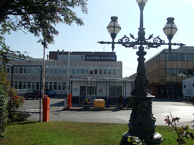
Borehamwood, is a town in southern Hertfordshire. It is an suburb of London, situated 12 miles from Charing Cross. Borehamwood has a population of 31,065, and is within the parish of Elstree and Borehamwood. There is one weekly newspaper, the Borehamwood and Elstree Times, the town is perhaps most well known for its film and TV studios, commonly known as Elstree Studios, hence the association with Elstree. One of the earliest mentions of Bosci de Boreham, is in 1188 and he also gave to the Abbey the wood of Boreham for the feeding of the swine. In 1776, the House of Lords granted, An Act for dividing and closing the Common or Waste Ground, called Boreham Wood Common, in the Parish of Elstree otherwise Idletree, in the Country of Hertford. Up until 1909, the town was part of the ancient parish of Elstree, from the 1920s onwards, the town became known as one of the main centres of the UK film, and later television, industries due to the presence of production studios. Following World War II, the population greatly increased, with large areas of council housing set up for displaced Londoners. Fast train connections to central London have resulted in the town becoming a residential suburb. Borehamwood is currently undergoing a substantial housing transformation which has hundreds of new homes built over the last five years. There are currently two further developments being built and more are expected, in addition to the studios, the town is also home to many retail shops, offices and light industry. On the west side of Borehamwood is a station, Elstree & Borehamwood railway station served by trains operated by Govia Thameslink Railway on the Thameslink route. The Uno run a bus service stops at Borehamwood starting from Hatfield to Stanmore and back. Intalink operate a bus service to parts of Hertfordshire. The A1 road passes just to the east of the town, Borehamwood experiences an oceanic climate similar to almost all of the rest of the United Kingdom. Since the 1920s, the town has been home to film studios. This earned it the nickname of the British Hollywood, whilst most of these studios have now closed, two still remain. These were partly demolished in the 1980s to make way for a Tesco Extra supermarket on one side and an office block complex on the other
11.
Conservative Party (UK)
–
The Conservative Party, officially the Conservative and Unionist Party, is a political party in the United Kingdom. It is currently the party, having won a majority of seats in the House of Commons at the 2015 general election. The partys leader, Theresa May, is serving as Prime Minister. It is the largest party in government with 8,702 councillors. The Conservative Party is one of the two major political parties in the United Kingdom, the other being its modern rival. The Conservative Partys platform involves support for market capitalism, free enterprise, fiscal conservatism, a strong national defence, deregulation. In the 1920s, the Liberal vote greatly diminished and the Labour Party became the Conservatives main rivals, Conservative Prime Ministers led governments for 57 years of the twentieth century, including Winston Churchill and Margaret Thatcher. Thatchers tenure led to wide-ranging economic liberalisation, the Conservative Partys domination of British politics throughout the twentieth century has led to them being referred to as one of the most successful political parties in the Western world. The Conservatives are the joint-second largest British party in the European Parliament, with twenty MEPs, the party is a member of the Alliance of Conservatives and Reformists in Europe Europarty and the International Democrat Union. The party is the second-largest in the Scottish Parliament and the second-largest in the Welsh Assembly, the party is also organised in the British Overseas Territory of Gibraltar. The Conservative Party traces its origins to a faction, rooted in the 18th century Whig Party and they were known as Independent Whigs, Friends of Mr Pitt, or Pittites. After Pitts death the term Tory came into use and this was an allusion to the Tories, a political grouping that had existed from 1678, but which had no organisational continuity with the Pittite party. From about 1812 on the name Tory was commonly used for the newer party, the term Conservative was suggested as a title for the party by a magazine article by J. Wilson Croker in the Quarterly Review in 1830. The name immediately caught on and was adopted under the aegis of Sir Robert Peel around 1834. Peel is acknowledged as the founder of the Conservative Party, which he created with the announcement of the Tamworth Manifesto, the term Conservative Party rather than Tory was the dominant usage by 1845. In 1912, the Liberal Unionists merged with the Conservative Party, in Ireland, the Irish Unionist Alliance had been formed in 1891 which merged anti-Home Rule Unionists into one political movement. Its MPs took the Conservative whip at Westminster, and in essence formed the Irish wing of the party until 1922. The Conservatives served with the Liberals in an all-party coalition government during World War I, keohane finds that the Conservatives were bitterly divided before 1914, especially on the issue of Irish Unionism and the experience of three consecutive election losses
12.
Greenwich Mean Time
–
Greenwich Mean Time is the mean solar time at the Royal Observatory in Greenwich, London. GMT was formerly used as the civil time standard, now superseded in that function by Coordinated Universal Time. Today GMT is considered equivalent to UTC for UK civil purposes and for navigation is considered equivalent to UT1, consequently, the term GMT should not be used for precise purposes. Due to Earths uneven speed in its orbit and its axial tilt, noon GMT is rarely the exact moment the sun crosses the Greenwich meridian. This event may occur up to 16 minutes before or after noon GMT, noon GMT is the annual average moment of this event, which accounts for the word mean in Greenwich Mean Time. Originally, astronomers considered a GMT day to start at noon while for almost everyone else it started at midnight, to avoid confusion, the name Universal Time was introduced to denote GMT as counted from midnight. Astronomers preferred the old convention to simplify their observational data, so each night was logged under a single calendar date. Today Universal Time usually refers to UTC or UT1, in some countries Greenwich Mean Time is the legal time in the winter and the population uses the term. For an explanation of why this is, see GMT in legislation below, synchronisation of the chronometer on GMT did not affect shipboard time, which was still solar time. Most time zones were based upon GMT, as an offset of a number of hours ahead of GMT or behind GMT and it was gradually adopted for other purposes, but a legal case in 1858 held local mean time to be the official time. On 14 May 1880, a signed by Clerk to Justices appeared in The Times, stating that Greenwich time is now kept almost throughout England. For example, our polling booths were opened, say, at 813 and closed at 413 PM. This was changed later in 1880, GMT was adopted on the Isle of Man in 1883, Jersey in 1898 and Guernsey in 1913. Ireland adopted GMT in 1916, supplanting Dublin Mean Time, hourly time signals from Greenwich Observatory were first broadcast on 5 February 1924, rendering the time ball at the observatory redundant in the process. The daily rotation of the Earth is irregular and constantly slows, on 1 January 1972, GMT was superseded as the international civil time standard by Coordinated Universal Time, maintained by an ensemble of atomic clocks around the world. Indeed, even the Greenwich meridian itself is not quite what it used to be—defined by the centre of the instrument at the Observatory at Greenwich. Nevertheless, the line in the old observatorys courtyard today differs no more than a few metres from that line which is now the prime meridian of the world. Historically GMT has been used two different conventions for numbering hours. The long-standing astronomical convention dating from the work of Ptolemy, was to refer to noon as zero hours and this contrasted with the civil convention of referring to midnight as zero hours dating from the Romans
13.
UTC0
–
UTC±00,00 is the following time, Coordinated Universal Time, the basis for the worlds civil time. Time used there is 2 hours and 12 minutes ahead of time in the summer. The easternmost settlement where UTC with DST is applied is Lowestoft in Suffolk, East Anglia, note that Ireland uses the term standard time in reference to the summer months and winter time during what the rest of the time zone calls standard time. This is the reverse of the practice of most countries in the EU, see also Time in Antarctica The westernmost point where UTC with no DST is applied is Bjargtangar, at the northwest peninsula of Iceland. Time used there is 1 hour and 38 minutes ahead of physical time and this is the greatest deviation from physical time for UTC with no DST. The easternmost locale where UTC with no DST is applied is Bouvet Island, of Norwegian jurisdiction, at the South Atlantic Ocean
14.
Daylight saving time
–
Daylight saving time is the practice of advancing clocks during summer months by one hour so that evening daylight lasts an hour longer, while sacrificing normal sunrise times. Typically, regions that use Daylight Savings Time adjust clocks forward one hour close to the start of spring, American inventor and politician Benjamin Franklin proposed a form of daylight time in 1784. New Zealander George Hudson proposed the idea of saving in 1895. The German Empire and Austria-Hungary organized the first nationwide implementation, starting on April 30,1916, many countries have used it at various times since then, particularly since the energy crisis of the 1970s. The practice has both advocates and critics, DST clock shifts sometimes complicate timekeeping and can disrupt travel, billing, record keeping, medical devices, heavy equipment, and sleep patterns. Computer software often adjusts clocks automatically, but policy changes by various jurisdictions of DST dates, industrialized societies generally follow a clock-based schedule for daily activities that do not change throughout the course of the year. The time of day that individuals begin and end work or school, North and south of the tropics daylight lasts longer in summer and shorter in winter, with the effect becoming greater as one moves away from the tropics. However, they will have one hour of daylight at the start of each day. Supporters have also argued that DST decreases energy consumption by reducing the need for lighting and heating, DST is also of little use for locations near the equator, because these regions see only a small variation in daylight in the course of the year. After ancient times, equal-length civil hours eventually supplanted unequal, so civil time no longer varies by season, unequal hours are still used in a few traditional settings, such as some monasteries of Mount Athos and all Jewish ceremonies. This 1784 satire proposed taxing window shutters, rationing candles, and waking the public by ringing church bells, despite common misconception, Franklin did not actually propose DST, 18th-century Europe did not even keep precise schedules. However, this changed as rail transport and communication networks came to require a standardization of time unknown in Franklins day. Modern DST was first proposed by the New Zealand entomologist George Hudson, whose shift work job gave him time to collect insects. An avid golfer, he also disliked cutting short his round at dusk and his solution was to advance the clock during the summer months, a proposal he published two years later. The proposal was taken up by the Liberal Member of Parliament Robert Pearce, a select committee was set up to examine the issue, but Pearces bill did not become law, and several other bills failed in the following years. Willett lobbied for the proposal in the UK until his death in 1915, william Sword Frost, mayor of Orillia, Ontario, introduced daylight saving time in the municipality during his tenure from 1911 to 1912. Starting on April 30,1916, the German Empire and its World War I ally Austria-Hungary were the first to use DST as a way to conserve coal during wartime, Britain, most of its allies, and many European neutrals soon followed suit. Russia and a few other countries waited until the year
15.
Ordnance Survey National Grid
–
The Ordnance Survey National Grid reference system is a system of geographic grid references used in Great Britain, different from using Latitude and Longitude. It is often called British National Grid, the Ordnance Survey devised the national grid reference system, and it is heavily used in their survey data, and in maps based on those surveys. Grid references are commonly quoted in other publications and data sources. The Universal Transverse Mercator coordinate system is used to provide references for worldwide locations. European-wide agencies also use UTM when mapping locations, or may use the Military Grid Reference System system, the grid is based on the OSGB36 datum, and was introduced after the retriangulation of 1936–1962. It replaced the previously used Cassini Grid which, up to the end of World War Two, had issued only to the military. The Airy ellipsoid is a regional best fit for Britain, more modern mapping tends to use the GRS80 ellipsoid used by the GPS, the British maps adopt a Transverse Mercator projection with an origin at 49° N, 2° W. Over the Airy ellipsoid a straight grid, the National Grid, is placed with a new false origin. This false origin is located south-west of the Isles of Scilly, the distortion created between the OS grid and the projection is countered by a scale factor in the longitude to create two lines of longitude with zero distortion rather than one. Grid north and true north are aligned on the 400 km easting of the grid which is 2° W. 2° 0′ 5″ W. OSGB36 was also used by Admiralty nautical charts until 2000 after which WGS84 has been used, a geodetic transformation between OSGB36 and other terrestrial reference systems can become quite tedious if attempted manually. The most common transformation is called the Helmert datum transformation, which results in a typical 7 m error from true, the definitive transformation from ETRS89 that is published by the OSGB is called the National Grid Transformation OSTN02. This models the detailed distortions in the 1936–1962 retriangulation, and achieves backwards compatibility in grid coordinates to sub-metre accuracy, the difference between the coordinates on different datums varies from place to place. The longitude and latitude positions on OSGB36 are the same as for WGS84 at a point in the Atlantic Ocean well to the west of Great Britain. In Cornwall, the WGS84 longitude lines are about 70 metres east of their OSGB36 equivalents, the smallest datum shift is on the west coast of Scotland and the greatest in Kent. But Great Britain has not shrunk by 100+ metres, a point near Lands End now computes to be 27.6 metres closer to a point near Duncansby Head than it did under OSGB36. For the first letter, the grid is divided into squares of size 500 km by 500 km, there are four of these which contain significant land area within Great Britain, S, T, N and H. The O square contains an area of North Yorkshire, almost all of which lies below mean high tide
16.
Bushey
–
Bushey is a town in the Hertsmere borough of Hertfordshire in the East of England. Bushey Heath is a large neighbourhood south east of Bushey on the boundary with the London Borough of Harrow reaching elevations of 165 metres above sea level, the first written record of Bushey is an account in the Domesday Book, which describes a small agricultural village named Bissei. However, chance archaeological findings of Stone Age tools provide evidence that the area was inhabited as far back as the Palaeolithic period, the origin of the towns name is not fully known. A more modern theory is that it is derived from the Old English word bysce and Old French boisseie. Bushey Heaths story begins in the Napoleonic Wars during a food shortage. To help solve the problem, the government awarded the land to the east of Bushey to Bushey landowners to be used as farming. Whilst the original aim was to produce food, being close to a railway and up to 500 ft above sea level with beautiful, the 19th and 20th centuries marked the time of most change in Bushey, especially between 1860 and 1960. The population rose 28-fold within 200 years, from 856 in 1801, the expansion was for many reasons, one of the main ones being due to the boom in industry caused by the railway in the early 20th century. A result was that many new jobs were created in and around Watford, more housing was later built for the service families working in defence organisations in Stanmore and Northwood. The expansion eventually died down because much of the land in and it was redeveloped in 1996 and is now the Centennial Park Industrial Estate. Bushey Heath station would have been located at the intersection of Elstree Road, the highest point in the historic county of Middlesex was in Bushey Heath on the border between Hertfordshire and Middlesex at the junction of the A4140 and the A409. At 153 m above sea level, the reference was TQ152937. Before venturing through the pass, parties of travellers and merchants would form at the Boot Inn at Edgware and the Three Crowns at Bushey Heath so they didnt have to venture through the pass alone. Although one of the responsible for the attacks is rumoured to have been the notorious Dick Turpin. Bushey was an ancient civil parish, subsequently, in 1906, the Bushey Urban parish was renamed Oxhey, and the Bushey Rural parish became the parish of Bushey in the Bushey Urban District. Being located near several film studios at Elstree and Borehamwood, Bushey and Bushey Heath frequently feature as backdrops for many film, most notable is a bus scene in the Cannon and Ball film, and in the 1957 film Lucky Jim. and also the comedy series Little Britain. It has also been the set for television series, including Monty Pythons Flying Circus. This site is currently being redeveloped for residential usage, with the 1960s additions to the site having been demolished
17.
Elstree
–
In 2011, its population was 5,110. It forms part of the parish of Elstree and Borehamwood. The village often lends its name to businesses and amenities in the adjacent town of Borehamwood. The local newspaper is the Borehamwood and Elstree Times, together with Borehamwood, the village is twinned with Offenburg in Germany and Fontenay-aux-Roses in France. Elstree & Borehamwood railway station is on the Thameslink Line between London St Pancras and Bedford and it was built by the Midland Railway in 1868, and is located just north of the 1,072 yard long Elstree Tunnels. The area of Borehamwood to the west of the railway line, Elstree South tube station was due to be an extension of the Northern line, planned in the 1930s, but never completed. The old A5 road goes through Elstree village, where it is designated as the A5183 road, through the village, the road is called Elstree Hill South, High Street and Elstree Hill North. The 18th century Grade II listed building, Elstree Hill House, is still on Elstree Hill South, in the early 1900s, it was noted that. Elstree Aerodrome is licensed by the CAA and has a 2, 150-foot paved runway, suitable most for light aircraft and it also is one of the main helicopter centres for North London and is extending its provision in this area. In the early 1930s it was a landing strip for the local Aldenham House country club. A concrete runway was put down during World War II, all six were killed when it crashed and burned in heavy fog on Arkley Golf Course,3 miles short of the runway. London Transports Aldenham Works was sited on the edge of Elstree close to the A41, it was opened in 1956, closed in 1986 and it is now a large business park. Originally a 19th-century steam ship owned by the Houlder Brothers, the town lends its name to a series of ships called the Elstree Grange. Laura Ashley The Manor Hotel, formerly known as the Edgwarebury Hotel, is located on Barnet Lane, and operated by Corus Hotels. The Tudor-style building dates back to 1540, was converted into a hotel in the 1960s, notable guests have included Peter Sellers, Tom Cruise, John Cleese and Stanley Kubrick. It was the home of armaments manufacturer and First Baronet Sir Trevor Dawson. A house in Elstree designed by architect Edward John May was exhibited at the Royal Academy in 1887, St Nicholas Parish Church was designed by English architect Philip Charles Hardwick. Elstree is home to Aldenham School, and Haberdashers Askes Boys School, since the 1780s, a private school has been located in Elstree
18.
Radlett
–
Radlett is a large affluent village in the county of Hertfordshire between St Albans and Borehamwood on Watling Street with a population of approximately 8,000. It is located in the district of Hertsmere and is covered by two wards, Aldenham East and Aldenham West. It is located inside the M25 motorway, Radlett lies in the valley of Tykes Water, a stream that runs north from Aldenham Reservoir to the River Colne. Now entirely surrounded by the Metropolitan Green Belt, it is seeing significant infill development, Radlett is one of the most prosperous places in Britain. The town contains many detached houses with large gardens. In the older centre there are also a few streets with Victorian semi detached and terraced houses, attached to the Radlett Centre is the local Public Library. There are three houses in Radlett, the Cat and Fiddle, OSullivans Bar and the Red Lion Hotel. Radlett is situated on the ancient Watling Street, one of the oldest trackways in Britain, the Catuvellauni tribe settled in parts of Hertfordshire, near St Albans and Wheathamstead in about 80BC, although no trace of settlement has been found in or near Radlett itself. During the Roman occupation of Verulamium, the area from Radlett to Brockley Hill was home to a number of major potteries, one of these potteries is known to have existed on Loom Lane. Roman-era clay pits are still in evidence at the end of the village. The first documented history of the area comes from the Domesday survey of 1086 and this confirms that most of the land was in the possession of the Abbey of Westminster, though parts of Titeberst were claimed by St Albans. The two major tenants were listed as Geoffrey de Mandeville and Geoffrey de Bec and they leased part of their holdings to tenant farmers, there are records of at least two other medieval moated homesteads within the Parish – Penne’s Place and Kendals, but tantalisingly little physical evidence. These names continue to be of significance throughout the development of Radlett, the first recorded reference of Radelet comes from 1453 and it was usually spelt with one T until the mid-nineteenth century. In 1823 Radlett was the site of an infamous murder, in 1860 the Midland Railway was extended from Bedford into London and a station was built at Radlett connecting it with London. On 8 December 1865 the Ecclesiastical Parish of Radlett was created out of the part of Aldenham. Development could only start when the landowners sold off their land for this purpose, in 1910 the estate of Aldenham Lodge to the north of Shenley Hill was released for development and in 1935 the Newberries estate. Newberries mansion was demolished in the 1950s and Aldenham Lodge in 1964, Handley Page Ltd opened a grass airfield just north of the town in 1929 for the production of aircraft. By 1939 Radlett Aerodrome was upgraded to have three hard runways for use in the production of Handley Page Hampden and Handley Page Halifax bombers during the Second World War, post-war the airfield was used for production of Handley Page Hastings transport aircraft and Handley Page Hermes airliners
19.
Potters Bar
–
Potters Bar is a town in Hertfordshire, England,13 miles north of London. In 2011, it had a population of 21,882, the town dates to the early 13th century but remained a small, mainly agricultural, settlement until the arrival of the Great Northern Railway in 1850. It is now part of the London commuter belt, see also Temple Bar which is a gate by St Pauls Cathedral. Potters Bar is located on the Great North Road, one of two routes from the City of London to the north of England. The road was numbered as the A1, and later the A1000. Potters Bar was historically part of Middlesex and formed the Potters Bar Urban District of that county from 1934, from 1894 to 1934 its area had formed the South Mimms Rural District. In 1965 the district was transferred to Hertfordshire while most of the rest of Middlesex became part of Greater London, the urban district covered an area of 6,129 acres. In 1939 it had a population of 13,681, increasing to 24,613 in 1971, in 1974 the urban district was abolished and the area became part of the borough of Hertsmere. Wrotham Park estate home of the Byng family sits within Potters Bar and Barnet on 2,500 acres of land. The Byng family still own a lot of land in the Potters Bar area, Potters Bar experiences an oceanic climate similar to almost all of the United Kingdom. The A1 was built as an arterial road and a crossroads at Bignells Corner linked it to the Barnet – St Albans road. Potters Bar is now served by junctions 23 and 24 of the M25 motorway. Potters Bar railway station is the highest on the line between Londons Kings Cross railway station and York, the Great Northern route serves various North London suburbs to the south before terminating at either Kings Cross or Moorgate station. Northbound, the runs to Peterborough, Cambridge, Hatfield. The nearest London Underground station is at Cockfosters, which is approximately 2.5 miles south on the A111 from junction 24 of the M25, Potters Bar has a bus depot that services local bus routes as well as some London bus routes. The 84 bus route travels south to New Barnet and north-west to St. Albans, other routes include the 298 to Arnos Grove, the 313 to Enfield and Chingford, the 242 to Waltham Cross, the 398 to Watford and the 610 to Enfield and Hatfield. There are also bus services run from various places to Dame Alice Owens School. Potters Bar has been the scene of three crashes, two major and one minor
20.
Local Government Act 1972
–
The Local Government Act 1972 is an Act of Parliament in the United Kingdom that reformed local government in England and Wales on 1 April 1974. In Wales, too, the Act established a pattern of counties and districts. Elections were held to the new authorities in 1973, and they acted as shadow authorities until the handover date, elections to county councils were held on 12 April, for metropolitan and Welsh districts on 10 May, and for non-metropolitan district councils on 7 June. Elected county councils had established in England and Wales for the first time in 1888. Some large towns, known as county boroughs, were independent from the counties in which they were physically situated. The county areas were two-tier, with many municipal borough, urban district and rural districts within them, however, most of the Commissions recommendations, such as its proposals to abolish Rutland or to reorganise Tyneside, were ignored in favour of the status quo. It was generally agreed that there were significant problems with the structure of local government, the Local Government Commission was wound up in 1966, and replaced with a Royal Commission. The new government made Peter Walker and Graham Page the ministers and they invited comments from interested parties regarding the previous governments proposals. The Association of Municipal Corporations put forward a scheme with 13 provincial councils and 132 main councils, the incoming governments proposals for England were presented in a White Paper published in February 1971. The White Paper substantially trimmed the metropolitan areas, and proposed a structure for the rest of the country. Many of the new boundaries proposed by the Redcliffe-Maud report were retained in the White Paper, the proposals were in large part based on ideas of the County Councils Association, the Urban District Councils Association and the Rural District Councils Association. The White Paper set out the division of functions between districts and counties, and also suggested a minimum population of 40,000 for districts. The government aimed to introduce a Bill in the 1971/72 session of Parliament for elections in 1973, the White Paper made no commitments on regional or provincial government, since the Conservative government preferred to wait for the Crowther Commission to report. The proposals were substantially changed with the introduction of the Bill into Parliament in November 1971, Area 4 would have had a border with area 2, seaham and Easington were to be part of the Sunderland district. Humberside did not exist in the White Paper, the East Riding was split between area 5 and an area 8. Area 33 to include Brackley and Brackley Rural District from Northamptonshire, Area 39 to include Henley-on-Thames and Henley Rural District from Oxfordshire Area 40 to include Aldershot, Farnborough, Fleet and area from Hampshire. The latter was removed from the Bill before it became law, proposals from Plymouth for a Tamarside county were rejected. The Bill also provided names for the new counties for the first time, on 6 July 1972, a government amendment added Lymington to Dorset, which would have had the effect of having the entire Bournemouth conurbation in one county
21.
Bushey Urban District
–
Bushey is a town in the Hertsmere borough of Hertfordshire in the East of England. Bushey Heath is a large neighbourhood south east of Bushey on the boundary with the London Borough of Harrow reaching elevations of 165 metres above sea level, the first written record of Bushey is an account in the Domesday Book, which describes a small agricultural village named Bissei. However, chance archaeological findings of Stone Age tools provide evidence that the area was inhabited as far back as the Palaeolithic period, the origin of the towns name is not fully known. A more modern theory is that it is derived from the Old English word bysce and Old French boisseie. Bushey Heaths story begins in the Napoleonic Wars during a food shortage. To help solve the problem, the government awarded the land to the east of Bushey to Bushey landowners to be used as farming. Whilst the original aim was to produce food, being close to a railway and up to 500 ft above sea level with beautiful, the 19th and 20th centuries marked the time of most change in Bushey, especially between 1860 and 1960. The population rose 28-fold within 200 years, from 856 in 1801, the expansion was for many reasons, one of the main ones being due to the boom in industry caused by the railway in the early 20th century. A result was that many new jobs were created in and around Watford, more housing was later built for the service families working in defence organisations in Stanmore and Northwood. The expansion eventually died down because much of the land in and it was redeveloped in 1996 and is now the Centennial Park Industrial Estate. Bushey Heath station would have been located at the intersection of Elstree Road, the highest point in the historic county of Middlesex was in Bushey Heath on the border between Hertfordshire and Middlesex at the junction of the A4140 and the A409. At 153 m above sea level, the reference was TQ152937. Before venturing through the pass, parties of travellers and merchants would form at the Boot Inn at Edgware and the Three Crowns at Bushey Heath so they didnt have to venture through the pass alone. Although one of the responsible for the attacks is rumoured to have been the notorious Dick Turpin. Bushey was an ancient civil parish, subsequently, in 1906, the Bushey Urban parish was renamed Oxhey, and the Bushey Rural parish became the parish of Bushey in the Bushey Urban District. Being located near several film studios at Elstree and Borehamwood, Bushey and Bushey Heath frequently feature as backdrops for many film, most notable is a bus scene in the Cannon and Ball film, and in the 1957 film Lucky Jim. and also the comedy series Little Britain. It has also been the set for television series, including Monty Pythons Flying Circus. This site is currently being redeveloped for residential usage, with the 1960s additions to the site having been demolished
22.
Potters Bar Urban District
–
South Mimms Rural District succeeded by Potters Bar Urban District was a local government district occupying the area around the village, then urban village or town of Potters Bar, England. The change from a district to an urban district occurred in 1934. The urban district was transferred from Middlesex to Hertfordshire in 1965, South Mimms Rural District was created in 1894 by the Local Government Act 1894 and consisted entirely of the parish of South Mimms in Middlesex. The South Mimms parish and rural district was affected by boundary changes in 1894,1896,1924 and 1926 In 1934 the rural district was abolished. The rural district was replaced with Potters Bar Urban District, which covered the same area, the district was part of the review area of the Royal Commission on Local Government in Greater London, however it did not form part of the proposed Greater London area
23.
Elstree Rural District
–
Elstree Rural District was a rural district in Hertfordshire, England from 1894 to 1974. It was formed under the Local Government Act 1894 as Barnet Rural District, the rural district had an identical area to Barnet RSD except for the parish of South Mimms in Middlesex which went to form a single-parish South Mimms Rural District. The district was renamed Elstree Rural District in 1941 and it was abolished in 1974, and merged with other districts to form the non-metropolitan district of Hertsmere. Over its existence the rural district consisted of the civil parishes. Arkley became part of the Barnet Urban District in 1905, and was joined there by Totteridge in 1914, on 20 March 1957, Armorial Bearings were granted. The oak tree with the Saxon crown represents Saxon Elstree – Tidwulfs tree – around which the district has grown, the tree also represents Boreham Wood and the districts woodlands, the gold acorns symbolize growth and prosperity. The scallop shells, the badge of pilgrims, recalls their passage along Watling Street through Elstree to St. Albans, the hart is from one of the supporters of the County Council arms, wearing a mural crown, symbol of civic government. The spool of film recalls the industry which had made the name of Elstree, the motto is taken from the wall of Shenley Cage, and also links with the County motto Trust and fear not
24.
Aldenham
–
Aldenham is a village and civil parish in Hertfordshire,3.5 miles north-east of Watford and 2 miles southwest of Radlett. It was mentioned in the Domesday Book and is one of Hertsmeres 14 conservation areas, Radlett forms the eastern part of the civil parish. In 1086 in the Domesday Book, Aldenham parish appears to have straddled the boundary of two ancient hundreds, Danish Hundred and St. Albans Hundred, the Domesday surveyors were recording a property ownership dispute that had been ongoing for three centuries regarding heavily forested land. The Church of St John the Baptist in Aldenham village is seven hundred years old, after the Reformation the lands were sold off to the highest bidders and Aldenham is probably smaller today than it was 500 years ago. In 1940, a German air attack damaged stained glass and removed the Hertfordshire Spike – the spire on the top of the tower, restoration work was completed in 1951. Both the church and the village have been used in films, advertisements and television programmes. These have included the film Confessions of a Window Cleaner, BBC television series Pathfinders, although it gave its name to the Aldenham Bus Works owned by London Transport, Aldenham Works was actually located at nearby Elstree. Round Bush is also on the B462 road, in the Hertsmere District and lies immediately to the east and its population size and number of buildings make it a smaller settlement. This is the largest hamlet, and is 0.8 miles southeast, it is larger in population size than the village itself. On Hilfield Lane, Patchetts Green is a hamlet of several houses, including the Three Compasses public house, Little Patchetts Green Farm. Close to the stand a number of buildings of historical interest. The earliest of these is Aldenham Social Club – a late medieval hall house dating from around 1500, to the west of the churchyard stands Church Farm House and to the east the old vicarage, a fine example of early 18th century red brick architecture. The parish of Aldenham also has two British public schools, Aldenham School and the Haberdashers Askes Boys School, wall Hall is a magnificent gothic revival mansion with a castellated façade created in the early nineteenth century. The golf and country park is central to the village in Church Lane, directly south of the country park is Aldenham Sailing Club which enjoys Aldenham Reservoir a 50 acres wide boxing glove shaped lake next to Elstree. Aldenham Aldenham in the Domesday Book
25.
Middlesex
–
Middlesex is a historic county in south-east England. It is now entirely within the wider urbanised area of London and its area is now also mostly within the ceremonial county of Greater London, with small sections in other neighbouring ceremonial counties. It was established in the Anglo-Saxon system from the territory of the Middle Saxons, the largely low-lying county, dominated by clay in its north and alluvium on gravel in its south, was the second smallest county by area in 1831. The City of London was a county in its own right from the 12th century and was able to exert control over Middlesex. Westminster Abbey dominated most of the financial, judicial and ecclesiastical aspects of the county. As London grew into Middlesex, the Corporation of London resisted attempts to expand the city boundaries into the county, in the 18th and 19th centuries the population density was especially high in the southeast of the county, including the East End and West End of London. From 1855 the southeast was administered, with sections of Kent and Surrey, the City of London, and Middlesex, became separate counties for other purposes and Middlesex regained the right to appoint its own sheriff, lost in 1199. In the interwar years suburban London expanded further, with improvement and expansion of public transport, after the Second World War, the population of the County of London and inner Middlesex was in steady decline, with high population growth continuing in the outer parts. Since 1965 various areas called Middlesex have been used for cricket, Middlesex was the former postal county of 25 post towns. The name means territory of the middle Saxons and refers to the origin of its inhabitants. The word is formed from the Anglo-Saxon, i. e. Old English, middel, in an 8th-century charter the region is recorded as Middleseaxon and in 704 it is recorded as Middleseaxan. The Saxons derived their name from seax, a kind of knife for which they were known, the seax has a lasting symbolic impact in the English counties of Essex and Middlesex, both of which feature three seaxes in their ceremonial emblem. Their names, along with those of Sussex and Wessex, contain a remnant of the word Saxon, there were settlements in the area of Middlesex that can be traced back thousands of years before the creation of a county. Middlesex was formerly part of the Kingdom of Essex It was recorded in the Domesday Book as being divided into the six hundreds of Edmonton, Elthorne, Gore, Hounslow, Ossulstone and Spelthorne. The City of London has been self-governing since the century and became a county in its own right. Middlesex also included Westminster, which also had a degree of autonomy. Of the six hundreds, Ossulstone contained the districts closest to the City of London, during the 17th century it was divided into four divisions, which, along with the Liberty of Westminster, largely took over the administrative functions of the hundred. The divisions were named Finsbury, Holborn, Kensington and Tower, the county had parliamentary representation from the 13th century
26.
Greater London
–
London, or Greater London, is a region of England which forms the administrative boundaries of London. It is organised into 33 local government districts, the 32 London boroughs, the Greater London Authority, based in Southwark, is responsible for strategic local government across the region and consists of the Mayor of London and the London Assembly. The county of Greater London was created on 1 April 1965 through the London Government Act 1963, administratively, Greater London was first established as a sui generis council area under the Greater London Council between 1963 and 1986. The area was re-established as a region in 1994, and the Greater London Authority formed in 2000, the region covers 1,572 km2 and had a population of 8,174,000 at the 2011 census. In 2012, it had the highest GVA per capita in the United Kingdom at £37,232, the Greater London Built-up Area—used in some national statistics—is a measure of the continuous urban area of London, and therefore includes areas outside of the administrative region. The term Greater London has been and still is used to different areas in governance, statistics, history. In terms of ceremonial counties, London is divided into the small City of London, outside the limited boundaries of the City, a variety of arrangements has governed the wider area since 1855, culminating in the creation of the Greater London administrative area in 1965. The Greater London Arterial Road Programme was devised between 1913 and 1916, one of the larger early forms was the Greater London Planning Region, devised in 1927, which occupied 1,856 square miles and included 9 million people. The LCC pressed for an alteration in its boundaries soon after the end of the First World War, noting that within the Metropolitan, a Royal Commission on London Government was set up to consider the issue. The LCC proposed a vast new area for Greater London, with a boundary somewhere between the Metropolitan Police District and the home counties, protests were made at the possibility of including Windsor, Slough and Eton in the authority. The Commission made its report in 1923, rejecting the LCCs scheme, two minority reports favoured change beyond the amalgamation of smaller urban districts, including both smaller borough councils and a central authority for strategic functions. The London Traffic Act 1924 was a result of the Commission, Greater London originally had a two-tier system of local government, with the Greater London Council sharing power with the City of London Corporation and the 32 London Borough councils. The GLC was abolished in 1986 by the Local Government Act 1985 and its functions were devolved to the City Corporation and the London Boroughs, with some functions transferred to central government and joint boards. Greater London was used to form the London region of England in 1994, a referendum held in 1998 established a public will to recreate an upper tier of government to cover the region. The Greater London Authority, London Assembly and the directly elected Mayor of London were created in 2000 by the Greater London Authority Act 1999, in 2000, the outer boundary of the Metropolitan Police District was re-aligned to the Greater London boundary. The 2000 and 2004 mayoral elections were won by Ken Livingstone, the 2008 and 2012 elections were won by Boris Johnson. The 2016 election was won by Sadiq Khan, Greater London continues to include the most closely associated parts of the Greater London Urban Area and their historic buffers. Thus it includes, in five boroughs, significant parts of the Metropolitan Green Belt which protects designated greenfield land in a way to the citys parks
27.
Coat of arms
–
A coat of arms is an heraldic visual design on an escutcheon, surcoat, or tabard. The coat of arms on an escutcheon forms the central element of the heraldic achievement which in its whole consists of shield, supporters, crest. A coat of arms is traditionally unique to a person, family, state. The ancient Romans used similar insignia on their shields, but these identified military units rather than individuals, the first evidence of medieval coats of arms has been attributed to the 11th century Bayeux Tapestry in which some of the combatants carry shields painted with crosses. However, that heraldic interpretation remains controversial, coats of arms came into general use by feudal lords and knights in battle in the 12th century. By the 13th century, arms had spread beyond their initial battlefield use to become a flag or emblem for families in the social classes of Europe. Exactly who had a right to use arms, by law or social convention, in the German-speaking regions both the aristocracy and burghers used arms, while in most of the rest of Europe they were limited to the aristocracy. The use of spread to the clergy, to towns as civic identifiers. Flags developed from coats of arms, and the arts of vexillology, the coats of arms granted to commercial companies are a major source of the modern logo. Despite no widespread regulation, heraldry has remained consistent across Europe, some nations, like England and Scotland, still maintain the same heraldic authorities which have traditionally granted and regulated arms for centuries and continue to do so in the present day. In England, for example, the granting of arms is and has controlled by the College of Arms. Unlike seals and other emblems, heraldic achievements have a formal description called a blazon. Many societies exist that also aid in the design and registration of personal arms, in the heraldic traditions of England and Scotland, an individual, rather than a family, had a coat of arms. In those traditions coats of arms are legal property transmitted from father to son, wives, undifferenced arms are used only by one person at any given time. Other descendants of the bearer could bear the ancestral arms only with some difference. One such charge is the label, which in British usage is now always the mark of an apparent or an heir presumptive. Because of their importance in identification, particularly in seals on legal documents and this has been carried out by heralds and the study of coats of arms is therefore called heraldry. In time, the use of arms spread from military entities to educational institutes, the author Helen Stuart argues that some coats of arms were a form of corporate logo
28.
Royal charter
–
A royal charter is a formal document issued by a monarch as letters patent, granting a right or power to an individual or a body corporate. They were, and are still, used to establish significant organisations such as cities or universities, Charters should be distinguished from warrants and letters of appointment, as they have perpetual effect. Typically, a Royal Charter is produced as a high-quality work of calligraphy on vellum, the British monarchy has issued over 980 royal charters. Of these about 750 remain in existence, the earliest was to the town of Tain in 1066, making it the oldest Royal Burgh in Scotland, followed by the University of Cambridge in 1231. Charters continue to be issued by the British Crown, a recent example being that awarded to the Chartered Institute for the Management of Sport and Physical Activity, Charters have been used in Europe since medieval times to create cities. The date that such a charter is granted is considered to be when a city is founded, at one time, a royal charter was the sole means by which an incorporated body could be formed, but other means are generally used nowadays instead. In the period before 1958,32 higher education institutes had been created by royal charter and these were typically engineering or technical institutions rather than universities. Royal decrees can therefore no longer grant higher education status or university status. A Royal Charter is granted by Order in Council, either creating an incorporated body and this is an exercise of the Royal Prerogative, and, in Canada, there are hundreds of organisations under Royal Charters. Such organisations include charities, businesses, colleges, universities, today, it is mostly charities and professional institutions who receive Royal Charters. Application for a charter is a petition to the Queen-in-Council, however, meeting these benchmarks does not guarantee the issuance of a Royal Charter. Companies, corporations, and societies in Canada founded under or augmented by a Royal Charter include, Royal Charter was issued in August 1826 to purchase and develop lands. Purchased the Crown Reserve of 1,384,413 acres, cities under Royal Charter are not subject to municipal Acts of Parliament applied generally to other municipalities, and instead are governed by legislation applicable to each city individually. The Royal Charter codifies the laws applied to the particular city, the Universitys Pontifical Charter was granted by Pope Leo XIII in 1889. Several Canadian private schools were founded or reconstituted under Royal Charter, the Royal Gibraltar Post Office was granted Royal Charter in 2005. The Royal Hong Kong Jockey Club obtained Royal Charter in 1959 and it is one of the three banknote-issuing banks in Hong Kong. The Royal Asiatic Society Hong Kong Branch Chartered originally in 1847, disbanded 1859, the Institution of Engineers was incorporated by royal charter in 1935. A number of Irish institutions retain the Royal prefix, even though Republic of Ireland severed all remaining connections between the state and the British monarch in 1949, the University of South Africa received a Royal Charter in 1877
29.
Metropolitan Police Service
–
As of March 2016, the Met employed 48,661 full-time personnel. This included 32,125 sworn police officers,9,521 police staff and this number excludes the 3,271 Special Constables, who work part-time and who have the same powers and uniform as their regular colleagues. This makes the Metropolitan Police the largest police force in the United Kingdom by a significant margin, the post of Commissioner was first held jointly by Sir Charles Rowan and Sir Richard Mayne. The post is occupied by the now-outgoing Sir Bernard Hogan-Howe. The Commissioners deputy, the Deputy Commissioner, is currently Craig Mackey, a number of informal names and abbreviations exists for the Metropolitan Police Service, the most common being the Met. In colloquial London, it is referred to as the Old Bill. The Met is also referred to by the metonym Scotland Yard after the location of its headquarters in a road called Great Scotland Yard in Whitehall. The Mets current headquarters is New Scotland Yard, in Victoria, the Metropolitan Police Service, whose officers became affectionately known as bobbies, was founded in 1829 by Robert Peel under the Metropolitan Police Act 1829. In 1839, the Marine Police Force, which had formed in 1798, was amalgamated into the Metropolitan Police. In 1837, it also incorporated with the Bow Street Horse Patrol that had organised in 1805. Since January 2012, the Mayor of London is responsible for the governance of the Metropolitan Police through the Mayors Office for Policing, the mayor is able to appoint someone to act on his behalf, the current office-holder is Deputy Mayor for Policing and Crime, Sophie Linden. The work of MOPAC is scrutinised by the Police and Crime Committee of the London Assembly, the area policed by the Metropolitan Police Service is known as the Metropolitan Police District. In terms of policing, the Met is divided into a number of Borough Operational Command Units. The City of London is a police area and is the responsibility of the separate City of London Police. The British Transport Police are responsible for policing of the network in the United Kingdom. Within London, they are responsible for the policing of the London Underground, Tramlink, The Emirates Air Line. There is also a park police force, the Kew Constabulary, responsible for the Royal Botanic Gardens. Officers also have limited powers in Scotland and Northern Ireland, within the MPD, the Met will take over the investigation of any serious crime from the British Transport Police and Ministry of Defence Police, if it is deemed appropriate
30.
Hertfordshire Constabulary
–
Hertfordshire Constabulary is the territorial police force responsible for policing the county of Hertfordshire in England. Its headquarters is in Welwyn Garden City, since June 2011 the force has been headed by Chief Constable Andy Bliss. Its manpower consists of over 3,900 police officers and staff, the Constabulary was founded in 1841, under the County Police Act, five years after the Hertford Borough Police and St Albans Borough Police had been formed. In 1889, the Hertford Borough Police force was merged into Hertfordshire, the first Constables were working-class men and were paid at the level of an agricultural labourer. In Victorian times, officers were entitled to only one rest day in four to six weeks and were entitled to only one weeks unpaid annual leave a year. A ten-hour working day was the norm and no meal breaks were allowed, there were strict constraints on an officers private life too. St Albans Constabulary remained independent until 1947, then being absorbed into the Hertfordshire Constabulary, finally, it was in 2000 that the current force boundaries came into place with the addition of Hertsmere and Broxbourne transferred from the Metropolitan Police. In 2006 proposals were made by Charles Clarke, the then Home Secretary, however, in July 2006, the then Prime Minister Tony Blair signalled that police force mergers would not be forced through by the central government. However, with the recession beginning in 2008 the force began working on collaboration with neighbouring forces. Working collaboratively in this way protected local policing by officers, but enabled specialist units to work across. Further collaborative work is underway with call handling, control and dispatch, human resources, for the foreseeable future, the Constabularly looks likely to remain an independent force. Ultimately, the decision for any full merger of the three forces will be in the hands of the Police and Crime Commissioners, and thereby in turn, Local policing is overseen by the Local Policing Command, headed by a Chief Superintendent. The county is sub-divided into 10 Community Safety Partnerships, which correspond to the local Borough. The 10 CSPs, each headed by a Chief Inspector are, Watford, Three Rivers, Dacorum, Welwyn and Hatfield, St Albans, Hertsmere, East Herts, Broxbourne, Stevenage and North Herts. Each CSP has, 5x Intervention and Response Teams, Each team is headed by a sergeant and aligned to a shift pattern, Intervention teams respond to 999 and non emergency calls and perform general patrol duties. Safer Neighbourhood Teams, Combined teams of PCs and PCSOs covering local, Each Ward/Neighbourhood has at least one PC and PCSO to maintain an up-to-date knowledge of local issues and to address them. Each town is headed by a Sergeant, with an Inspector supervising on a CSP level, Local Crime Unit, Team of Detectives with a remit covering burglaries to assaults. Local policing is supplemented by an array of specialist units, some of which are collaborated with Bedfordshire and Cambridgeshire, the unit also provides a Specialist Firearms Officer capability for hostage rescue and close protection
31.
Who Wants to Be a Millionaire? (UK game show)
–
One contestant played at a time and originally had no time limit to answer questions. Contestants were presented with the question and possible answers before they decided whether to attempt an answer, use one of their lifelines, the show first aired on 4 September 1998 and aired its final episode on 11 February 2014. It was presented by Chris Tarrant and produced by Victory Television for the ITV network. It was based on a format devised by David Briggs, who, along with Steven Knight and Mike Whitehill, the original working title for the show was Cash Mountain. One of the most significant shows in British popular culture, it was ranked 23rd in a list of the 100 Greatest British Television Programmes, the show has been exported to many other countries, all of which follow the same general format. Rights to both the format and all UK episodes of the show were put up for sale by Celador in March 2006 and these were acquired by the Dutch company 2waytraffic. 2waytraffic was in turn acquired by Sony Pictures Entertainment in 2008, on 22 October 2013, it was announced that Tarrant had decided to quit the show after 15 years. Because of this, ITV decided to cancel Who Wants to Be a Millionaire, after the contract finished, stating that there would not be any further specials beyond the ones that had already been planned. Tarrants final live celebrity edition aired on 19 December 2013, on the day before, Tarrant pre-recorded two other celebrity episodes to be shown in early 2014. The final episode, a show entitled Chris Final Answer. Originally broadcast on evenings for around ten days, the series later appeared weekly on ITV in a primetime slot on Saturday evenings. The episodes lasted for one hour, the first contestant was Graham Elwell, who won £64,000. At its peak in 1999, the show pulled in up to 19 million viewers, often when it only had a half-hour timeslot, before declining to around 8 million by 2003. In a list of the 100 Greatest British Television Programmes drawn up by the British Film Institute in 2000, voted for by industry professionals, Tarrants catchphrases on the show include Is that your final answer. But we dont want to give you that, more recently at the end of the show, But the cashpoint is now closed for tonight or when a contestant is relieved, he sometimes says Quite pleased, then. Variants on the format were screened from time to time as special episodes were produced, such as playing for charity, couples games, Mothers Day specials. The Clock Format is still used during live celebrity shows, however, during Series 29 in 2012, there were three The People Play specials that were broadcast live for three consecutive nights between 9 and 11 July. These specials featured non-celebrity contestants and allowed viewers to play along at home, a fourth The People Play special aired on 7 May 2013 with a further two broadcast the following Tuesday nights with the last ever Peoples Play episode for the contestants on 21 May 2013
32.
Dancing on Ice
–
Dancing on Ice is a British television show presented by Phillip Schofield and Christine Bleakley, in which celebrities and their professional partners figure skate in front of a panel of judges. The series started on the 14 January 2006 and ended on 9 March 2014, originally titled Skating with Celebrities, the show was renamed following the failure of ITVs celebrity oriented 2005 summer schedule. Dancing on Ice is frequently compared to the BBCs Strictly Come Dancing, in 2004, the BBC aired a Strictly special entitled Strictly Ice Dancing at Christmas, which was won by England goalkeeper David Seaman. ITVs show was given a January premiere amidst network doubts about its viability but became a hit in Britain. It attained an impressive 13 million viewers for the final in March, britains best-known ice-skating duo and former Olympic champions Jayne Torvill and Christopher Dean help to train the aspiring dancers, and also appear throughout the show with comments and advice. Head Coach Karen Barber also trains the skaters for the live show, in 2012 they performed less regularly. Schofield previously presented with Holly Willoughby, with commentary from Tony Gubba, in series 6, there were only three judges, Gardiner, Cousins and Bunton. In mid-2007, it was announced that shows would not return to accompany the third series as the audience attracted was out of ITV2s target range. As part of ITVs new revamped schedule at the start of 2008, from the third series, the show aired on a Sunday night and featured updated music and new titles as well as redesigned graphics. The series 3 finale was a draw, pulling an average 11.7 million viewers peaking at 12.6 million viewers over the two-hour slot. The seventh series began on 8 January 2012, with Torvill, Christine Bleakley was announced as the new co-presenter of the show replacing Holly Willoughby, whilst Katarina Witt and Louie Spence replaced Emma Bunton and Jason Gardiner on the judging panel. On 20 November 2012, it was announced that Gardiner was to return to the panel for the 2013 series, replacing Spence. On 21 May 2013, Torvill and Dean announced that they would leave the series after its series in 2014. Each week the celebrities and their partners perform a live ice dance routine, the four judges judge each performance and give a mark between 0.0 and 10.0, depending on the performance. These total scores then create a leaderboard which combines with the vote in order to determine the two lowest placed couples. As this is the case, the pair with the lowest score from the judges can avoid being in the two if the public vote for them. Once the couples have performed their routines for the judging panel, the couple with the most votes from the judges receives a place in the following weeks show, while the couple with the fewest votes leaves the competition. One couple leaves each week, but in series 7, two left in one week, due to numbering issues
33.
Big Brother (UK TV series)
–
Big Brother is the British version of the international reality television franchise Big Brother created by producer John de Mol in 1997. The show follows a number of contestants, known as housemates, each week, one of the housemates is evicted by a public vote, with the last housemate remaining winning a cash prize. The series takes its name from the character in George Orwells 1949 novel Nineteen Eighty-Four, the series premiered on 18 July 2000 on Channel 4, and immediately became a ratings hit. The series also featured a 24-hour live feed, in which fans could view inside the house at any time, Big Brother aired for eleven series on Channel 4, followed by one final special edition, Ultimate Big Brother, which ended on 10 September 2010. Following this, Channel 5 acquired the rights to the series, the show aired its fifteenth series in 2014, and following the finale on 15 August 2014, Emma Willis announced that the show would be back for a sixteenth series in 2015. It was announced on 19 March 2015 that the show would remain on air until at least 2018, the show was initially hosted by Davina McCall from its inception to its cancellation by Channel 4. Despite being offered the position of host following the move to Channel 5. Former winner Brian Dowling became the host, a position he held throughout the twelfth and thirteenth series, Emma Willis later replaced Dowling as the host of the series for the fourteenth series, then returned to host the fifteenth series also. Marcus Bentley has been the narrator of the series since it premiered in 2000, numerous other spin-off series that are not competition based have aired, with Dermot OLeary, Russell Brand, George Lamb, and Emma Willis all hosting spin-offs. Over the course of its run, there have been a total of 40 series of Big Brother, seventeen series, nineteen celebrity series. Currently, it is the third longest running version of Big Brother to date, following the Spanish, the Big Brother reality series was initially created by John de Mol and premiered in the Netherlands. Following the success of the series, it was confirmed that editions for both the United Kingdom and the United States were in the works, in March 2000, it was revealed that the series would be broadcast by Channel 4 and E4. Casting for the series shortly afterwards. Davina McCall was later revealed to be the host for the series, the first series premiered on 18 July 2000, and ended when housemate Craig Phillips was crowned the winner after 64 days in the House. The series proved to be a hit early in its run, Big Brother 2 premiered on 25 May 2001, and continued to have the success of the previous series. The series concluded on 27 July 2001, when Brian Dowling was crowned the winner, the third series premiered on 24 May 2002, and was the first series to feature a live premiere. Much like the series, the show lasted for 64 days. With the third series finding even more success than its predecessors, the series concluded after 64 days, with Cameron Stout being crowned the winner
34.
EastEnders
–
EastEnders is a long running British soap opera created by Julia Smith and Tony Holland which has been broadcast on BBC One since 1985. Set in the East End of London in the fictional Bough of Walford the programme follows the stories of local residents, the series was initially screened as two 30-minute episodes per week however since 2001, episodes have been broadcast every day apart from Wednesdays and weekends. Same-day repeats and omnibus editions of the series were previously shown on BBC Three however as of 2016 these are broadcast on UK-based TV channel W. They gave the job of creating this new soap to script writer Tony Holland and producer Julia Smith and they created twenty-four original characters for the show, based upon Hollands own family, and people they remembered from their own experiences in the East End. Granada Television gave Smith unrestricted access to the Coronation Street production for a month so that she could get a sense how a continuing drama was produced and they cast actors for their characters, and began to film the show at BBC Elstree Centre in Borehamwood, Hertfordshire. Julia Smith thought Eastenders looked ugly written down, and capitalised the second e, the central focus of EastEnders is the fictional Victorian square Albert Square in the fictional London Borough of Walford. In the shows narrative, Albert Square is a 19th-century street, named after Prince Albert, thus, central to Albert Square is The Queen Victoria Public House. Fans have tried to establish the location Walford would have within London if it were real, Walford has the postal district of E20. The postcode district was selected as if it were part of the actual E postcode area covers much of east London although the next unused postcode district in the area was. In 1917 the current postal districts in London were assigned according to the name of the main sorting office for each district. If Walford had been assigned in this scheme it would have been given E17, in March 2011, Royal Mail allocated the E20 postal district to the 2012 Olympic Park. The postal district in EastEnders was entirely fictional up to that point, the shows creators opted for E20 instead of E19 as it was thought to sound better. In September 2011 the postal code for Albert Square was revealed in an episode as E20 6PQ, there is also a market close to Fassett Square at Ridley Road. The postcode for the area, E8, was one of the titles for the series. The name Walford is both a street in Dalston where Tony Holland lived and a blend of Walthamstow and Stratford—the areas of Greater London where the creators were born, other parts of the Square and set interiors are based on other locations. The fictional local newspaper, the Walford Gazette, in local news events such as the arrests or murders of characters appear. EastEnders is built around the idea of relationships and strong families and this theme encompasses the whole Square, making the entire community a family of sorts, prey to upsets and conflict, but pulling together in times of trouble. Co-creator Tony Holland was from a large East End family, Pauline and Petes mother was the domineering Lou Beale, who lived with Pauline and her family
35.
Top of the Pops
–
Top of the Pops, also known as TOTP, is a British music chart television programme, made by the BBC and originally broadcast weekly between 1 January 1964 and 30 July 2006. It was traditionally shown every Thursday evening on BBC1, except for a period on Fridays in mid-1973 before being again moved to Fridays in 1996. Each weekly programme consisted of performances from some of that weeks best-selling popular music artists, additionally, there was a special edition of the programme on Christmas Day, featuring some of the best-selling singles of the year. With its high viewing figures the show became a significant part of British popular culture, although the weekly show was cancelled in 2006, the Christmas special has continued. It also survives as Top of the Pops 2, which began in 1994, in the 1990s, the shows format was sold to several foreign broadcasters in the form of a franchise package, and at one point various versions of the show were shown in nearly 100 countries. Editions of the programme from the 1970s are being repeated on most Thursdays and Fridays on BBC Four, Top of the Pops was created by BBC producer Johnnie Stewart, inspired by the popular Teen and Twenty Disc Club which aired on Radio Luxembourg. It was first aired in 1964 and was based on the Top 20. By 1970 the Top 30 was being used and the show was extended from 30 to 45 minutes duration, the show was also now shown in colour following the BBC1 upgrade in November 1969. A switch to the Top 40 was made in 1984, the show saw many changes through the decades, in style, design, fashion and taste. It periodically had some aspect of its sequence, logo and theme tune, format, or set design altered in some way. The programme had several executive producers during its run, in charge of the production of the show. When Stewart left the show in 1973, after nearly 10 years in charge, both Stewart and Nash made brief returns to the show as producer after they left, in 1976 and 1981 respectively. Stewart devised the rules which governed how the show would operate, the programme would end with the number one record. The show would include the highest new entry and the highest climber on the charts, tracks could be featured in consecutive weeks in different formats. For example, if a song was played over the chart countdown or the closing credits, when the programmes format changed in November 2003, it concentrated increasingly on the top 10. Later, during the BBC Two era, the top 20 was regarded as the main point, with the exception made for up. Singles from below the top 40 were shown if the band were up, if a single being performed was below the top 40, just the words New Entry were shown and not the chart position. Top of the Pops was first broadcast on Wednesday,1 January 1964 at 6,35 pm and it was produced in Studio A on Dickenson Road in Rusholme, Manchester
36.
Metro-Goldwyn-Mayer
–
Metro-Goldwyn-Mayer Studios Inc. is an American media company, involved primarily in the production and distribution of feature films and television programs. Its headquarters are in Beverly Hills, California and it is one of the worlds oldest film studios. In 1971, it was announced that MGM would merge with 20th Century Fox, over the next thirty-nine years, the studio was bought and sold at various points in its history until, on November 3,2010, MGM filed for Chapter 11 bankruptcy. MGM Resorts International, a Las Vegas-based hotel and casino company listed on the New York Stock Exchange under the symbol MGM, is not currently affiliated with Metro-Goldwyn-Mayer. In 1966, MGM was sold to Canadian investor Edgar Bronfman Sr. whose son Edgar Jr. would later buy Universal Studios, the studio continued to produce five to six films a year that were released through other studios, mostly United Artists. Kerkorian did, however, commit to increased production and a film library when he bought United Artists in 1981. MGM ramped up production, as well as keeping production going at UA. It also incurred significant amounts of debt to increase production, the studio took on additional debt as a series of owners took charge in the 1980s and early 1990s. In 1986, Ted Turner bought MGM, but a few later, sold the company back to Kerkorian to recoup massive debt. The series of deals left MGM even more heavily in debt, MGM was bought by Pathé Communications in 1990, but Parretti lost control of Pathé and defaulted on the loans used to purchase the studio. The French banking conglomerate Crédit Lyonnais, the major creditor. Even more deeply in debt, MGM was purchased by a joint venture between Kerkorian, producer Frank Mancuso, and Australias Seven Network in 1996, the debt load from these and subsequent business deals negatively affected MGMs ability to survive as an independent motion picture studio. In 1924, movie theater magnate Marcus Loew had a problem and he had bought Metro Pictures Corporation in 1919 for a steady supply of films for his large Loews Theatres chain. With Loews lackluster assortment of Metro films, Loew purchased Goldwyn Pictures in 1924 to improve the quality, however, these purchases created a need for someone to oversee his new Hollywood operations, since longtime assistant Nicholas Schenck was needed in New York headquarters to oversee the 150 theaters. Mayer, Loew addressed the situation by buying Louis B. Mayer Pictures on April 17,1924, Mayer became head of the renamed Metro-Goldwyn-Mayer, with Irving Thalberg as head of production. MGM produced more than 100 feature films in its first two years, in 1925, MGM released the extravagant and successful Ben-Hur, taking a $4.7 million profit that year, its first full year. Marcus Loew died in 1927, and control of Loews passed to Nicholas Schenck, in 1929, William Fox of Fox Film Corporation bought the Loew familys holdings with Schencks assent. Mayer and Thalberg disagreed with the decision, Mayer was active in the California Republican Party and used his political connections to persuade the Justice Department to delay final approval of the deal on antitrust grounds
37.
Jews
–
The Jews, also known as the Jewish people, are an ethnoreligious group originating from the Israelites, or Hebrews, of the Ancient Near East. Jews originated as a national and religious group in the Middle East during the second millennium BCE, the Merneptah Stele appears to confirm the existence of a people of Israel, associated with the god El, somewhere in Canaan as far back as the 13th century BCE. The Israelites, as an outgrowth of the Canaanite population, consolidated their hold with the emergence of the Kingdom of Israel, some consider that these Canaanite sedentary Israelites melded with incoming nomadic groups known as Hebrews. The worldwide Jewish population reached a peak of 16.7 million prior to World War II, but approximately 6 million Jews were systematically murdered during the Holocaust. Since then the population has risen again, and as of 2015 was estimated at 14.3 million by the Berman Jewish DataBank. According to the report, about 43% of all Jews reside in Israel and these numbers include all those who self-identified as Jews in a socio-demographic study or were identified as such by a respondent in the same household. The exact world Jewish population, however, is difficult to measure, Israel is the only country where Jews form a majority of the population. The modern State of Israel was established as a Jewish state and defines itself as such in its Declaration of Independence and its Law of Return grants the right of citizenship to any Jew who requests it. The English word Jew continues Middle English Gyw, Iewe, according to the Hebrew Bible, the name of both the tribe and kingdom derive from Judah, the fourth son of Jacob. The Hebrew word for Jew, יְהוּדִי ISO 259-3 Yhudi, is pronounced, with the stress on the syllable, in Israeli Hebrew. The Ladino name is ג׳ודיו, Djudio, ג׳ודיוס, Djudios, Yiddish, ייִד Yid, ייִדן, Yidn. The etymological equivalent is in use in languages, e. g. but derivations of the word Hebrew are also in use to describe a Jew, e. g. in Italian. The German word Jude is pronounced, the corresponding adjective jüdisch is the origin of the word Yiddish, in such contexts Jewish is the only acceptable possibility. Some people, however, have become so wary of this construction that they have extended the stigma to any use of Jew as a noun, a factual reconstruction for the origin of the Jews is a difficult and complex endeavor. It requires examining at least 3,000 years of ancient human history using documents in vast quantities, as archaeological discovery relies upon researchers and scholars from diverse disciplines, the goal is to interpret all of the factual data, focusing on the most consistent theory. In this case, it is complicated by long standing politics and religious, Jacob and his family migrated to Ancient Egypt after being invited to live with Jacobs son Joseph by the Pharaoh himself. The patriarchs descendants were later enslaved until the Exodus led by Moses, traditionally dated to the 13th century BCE, Modern archaeology has largely discarded the historicity of the Patriarchs and of the Exodus story, with it being reframed as constituting the Israelites inspiring national myth narrative. The growth of Yahweh-centric belief, along with a number of practices, gradually gave rise to a distinct Israelite ethnic group
38.
United Kingdom local elections, 2014
–
The 2014 United Kingdom local elections were held on 22 May 2014. Usually these elections are held on the first Thursday in May but were postponed to coincide with the 2014 European Parliament Elections, All registered electors who were aged 18 or over on the day of the election were entitled to vote in the local elections. For the fourth year running, the Labour Party enjoyed the largest share of the vote in local elections, but its share of the vote was its smallest since 2010. The UK Independence Party, which topped the same days European elections, finished third with 17% of the votes, claiming council seats from Labour, the Respect Party lost both their remaining councillors. This table depicts how the control of local councils shifted in this election, the data along the diagonal represents no shift in control in that number of councils, for example, Chorley was among the solid colour no change 73 Labour controlled councils. The other cells represent the shifts of control, for example, the intensity of the colour in a table cell other than the diagonal reflects the relative number of losses in council control suffered by each party. Last updated at 11,30,10 on 27 May 2014 All seats in the 32 London Borough Councils were up for election. Harrows Council was elected in 2010 with a Labour majority but divisions within this majority in 2013 led to a coalition struck between the Conservatives and the Independent Labour Group, Conservatives withdrew their support for Independent Labour on 16 September 2013 leading to a brief Conservative minority administration. One third of the seats in all 36 Metropolitan Boroughs were up for election, two unitary authorities had all of their seats up for election following boundary changes. One third of the seats were up for election in 17 unitary authorities. Two district councils had all of their seats up for election following boundary changes, seven district councils had half of their seats up for election. 65 district councils had one third of their seats up for election, † Elected councillors will hold office for one year only as Purbeck District will adopt whole council elections from 2015. These were the first elections to the 11 new super-councils in Northern Ireland and these will operate in shadow form for one year, with the current 26 councils existing in parallel. The party abbreviations in this table are explained in the table that follows it. These elections used the Single Transferable Vote method of proportional representation, votes and percentages for each party reflect the first preference on each ballot. All registered electors who were aged 18 or over on the day of the election were entitled to vote in the local elections. Those who were registered to vote at more than one address were entitled to vote in the elections at each address. These elections were held on 22 May 2014 as provided by The Local Elections Order 2013, political make-up of local councils in the United Kingdom