Highland Boundary Fault
Videos
Photos
The Highland Boundary Fault is a major fault zone that traverses Scotland from Arran and Helensburgh on the west coast to Stonehaven in the east. It separates two different geological terranes which give rise to two distinct physiographic terrains: the Highlands and the Lowlands, and in most places it is recognisable as a change in topography. Where rivers cross the fault, they often pass through gorges, and the associated waterfalls can be a barrier to salmon migration.
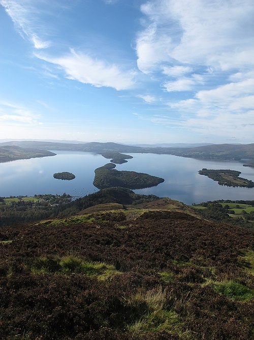
View along the Highland Boundary Fault from Conic Hill – the topographic ridge is mainly due to the presence of Devonian age conglomerates on the southwestern side of the fault and can be traced across Loch Lomond on the islands of Inchcailloch, Torrinch, Creinch and Inchmurrin, to Ben Bowie on the western shore

Altered serpentinite and associated sediments of the Highland Border Complex caught up in the fault zone – exposed on Druim nam Buraich, near Balmaha

Lower Devonian sandstones and conglomerates of the Inchmurrin Member dipping steeply to the southeast close to the Highland Boundary Fault trace near Balmaha
Isle of Arran
Videos
Photos
The Isle of Arran or simply Arran is an island off the west coast of Scotland. It is the largest island in the Firth of Clyde and the seventh-largest Scottish island, at 432 square kilometres (167 sq mi). Historically part of Buteshire, it is in the unitary council area of North Ayrshire. In the 2011 census it had a resident population of 4,629. Though culturally and physically similar to the Hebrides, it is separated from them by the Kintyre peninsula. Often referred to as "Scotland in Miniature", the Island is divided into highland and lowland areas by the Highland Boundary Fault and has been described as a "geologist's paradise".

Arran Sunset Taken from Bell Stane, Ardneil Bay, 2007

Cìr Mhòr and Caisteal Abhail seen from North Goatfell

Lochranza village and castle

Holy Island as seen from Arran