1.
Texas
–
Texas is the second largest state in the United States by both area and population. Other major cities include Austin, the second most populous state capital in the U. S. Texas is nicknamed the Lone Star State to signify its former status as an independent republic, and as a reminder of the states struggle for independence from Mexico. The Lone Star can be found on the Texan state flag, the origin of Texass name is from the word Tejas, which means friends in the Caddo language. Due to its size and geologic features such as the Balcones Fault, although Texas is popularly associated with the U. S. southwestern deserts, less than 10 percent of Texas land area is desert. Most of the centers are located in areas of former prairies, grasslands, forests. Traveling from east to west, one can observe terrain that ranges from coastal swamps and piney woods, to rolling plains and rugged hills, the term six flags over Texas refers to several nations that have ruled over the territory. Spain was the first European country to claim the area of Texas, Mexico controlled the territory until 1836 when Texas won its independence, becoming an independent Republic. In 1845, Texas joined the United States as the 28th state, the states annexation set off a chain of events that caused the Mexican–American War in 1846. A slave state before the American Civil War, Texas declared its secession from the U. S. in early 1861, after the Civil War and the restoration of its representation in the federal government, Texas entered a long period of economic stagnation. One Texan industry that thrived after the Civil War was cattle, due to its long history as a center of the industry, Texas is associated with the image of the cowboy. The states economic fortunes changed in the early 20th century, when oil discoveries initiated a boom in the state. With strong investments in universities, Texas developed a diversified economy, as of 2010 it shares the top of the list of the most Fortune 500 companies with California at 57. With a growing base of industry, the leads in many industries, including agriculture, petrochemicals, energy, computers and electronics, aerospace. Texas has led the nation in export revenue since 2002 and has the second-highest gross state product. The name Texas, based on the Caddo word tejas meaning friends or allies, was applied by the Spanish to the Caddo themselves, during Spanish colonial rule, the area was officially known as the Nuevo Reino de Filipinas, La Provincia de Texas. Texas is the second largest U. S. state, behind Alaska, though 10 percent larger than France and almost twice as large as Germany or Japan, it ranks only 27th worldwide amongst country subdivisions by size. If it were an independent country, Texas would be the 40th largest behind Chile, Texas is in the south central part of the United States of America. Three of its borders are defined by rivers, the Rio Grande forms a natural border with the Mexican states of Chihuahua, Coahuila, Nuevo León, and Tamaulipas to the south
2.
United States
–
Forty-eight of the fifty states and the federal district are contiguous and located in North America between Canada and Mexico. The state of Alaska is in the northwest corner of North America, bordered by Canada to the east, the state of Hawaii is an archipelago in the mid-Pacific Ocean. The U. S. territories are scattered about the Pacific Ocean, the geography, climate and wildlife of the country are extremely diverse. At 3.8 million square miles and with over 324 million people, the United States is the worlds third- or fourth-largest country by area, third-largest by land area. It is one of the worlds most ethnically diverse and multicultural nations, paleo-Indians migrated from Asia to the North American mainland at least 15,000 years ago. European colonization began in the 16th century, the United States emerged from 13 British colonies along the East Coast. Numerous disputes between Great Britain and the following the Seven Years War led to the American Revolution. On July 4,1776, during the course of the American Revolutionary War, the war ended in 1783 with recognition of the independence of the United States by Great Britain, representing the first successful war of independence against a European power. The current constitution was adopted in 1788, after the Articles of Confederation, the first ten amendments, collectively named the Bill of Rights, were ratified in 1791 and designed to guarantee many fundamental civil liberties. During the second half of the 19th century, the American Civil War led to the end of slavery in the country. By the end of century, the United States extended into the Pacific Ocean. The Spanish–American War and World War I confirmed the status as a global military power. The end of the Cold War and the dissolution of the Soviet Union in 1991 left the United States as the sole superpower. The U. S. is a member of the United Nations, World Bank, International Monetary Fund, Organization of American States. The United States is a developed country, with the worlds largest economy by nominal GDP. It ranks highly in several measures of performance, including average wage, human development, per capita GDP. While the U. S. economy is considered post-industrial, characterized by the dominance of services and knowledge economy, the United States is a prominent political and cultural force internationally, and a leader in scientific research and technological innovations. In 1507, the German cartographer Martin Waldseemüller produced a map on which he named the lands of the Western Hemisphere America after the Italian explorer and cartographer Amerigo Vespucci
3.
County seat
–
A county seat is an administrative center, seat of government, or capital city of a county or civil parish. The term is used in the United States, Canada, Romania, China, in the United Kingdom and Ireland, county towns have a similar function. In the United States, counties are the subdivisions of a state. Depending on the state, counties may provide services to the public, impose taxes. Some types of subdivisions, such as townships, may be incorporated or unincorporated. The city, town, or populated place that houses county government is known as the seat of its respective county, a county seat is usually, but not always, an incorporated municipality. The exceptions include the county seats of counties that have no incorporated municipalities within their borders, such as Arlington County, Virginia, likewise, some county seats may not be incorporated in their own right, but are located within incorporated municipalities. For example, Cape May Court House, New Jersey, though unincorporated, is a section of Middle Township, in some of the colonial states, county seats include or formerly included Court House as part of their name. Most counties have only one county seat, an example is Harrison County, Mississippi, which lists both Biloxi and Gulfport as county seats. The practice of multiple county seat towns dates from the days when travel was difficult, there have been few efforts to eliminate the two-seat arrangement, since a county seat is a source of pride for the towns involved. There are 36 counties with multiple county seats in 11 states, Coffee County, for example, the official county seat is Greensboro, but an additional courthouse has been located in nearby High Point since 1938. For example, Clearwater is the county seat of Pinellas County, Florida, in New England, the town, not the county, is the primary division of local government. Historically, counties in this region have served mainly as dividing lines for the judicial systems. Connecticut and Rhode Island have no county level of government and thus no county seats, in Vermont, Massachusetts, and Maine the county seats are legally designated shire towns. County government consists only of a Superior Court and Sheriff, both located in the shire town. Bennington County has two towns, but the Sheriff is located in Bennington. In Massachusetts, most government functions which would otherwise be performed by county governments in other states are performed by town governments. As such, Massachusetts has dissolved many of its county governments, two counties in South Dakota have their county seat and government services centered in a neighboring county
4.
Sierra Blanca, Texas
–
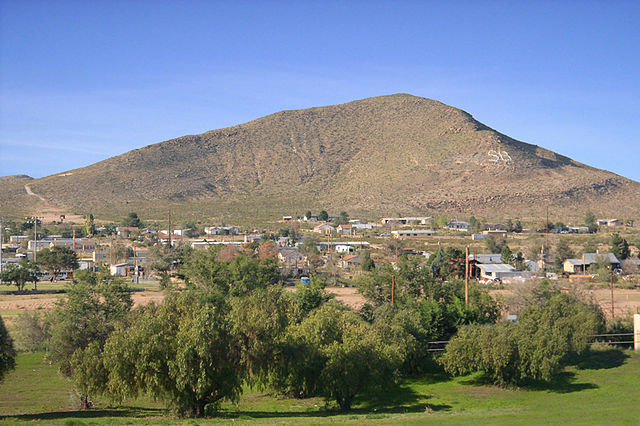
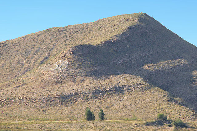
Sierra Blanca is a census-designated place in and the county seat of Hudspeth County, Texas, in the United States. The town is part of the Trans-Pecos region of far western Texas, the town is located northeast from the Mexican border and is located within the Mountain Time Zone. As of the 2010 census, the population was 553, the town was founded in 1881 at the completion point of a long-sought southern transcontinental railway. Sierra Blanca has served as the junction of the Southern Pacific, Hudspeth County was formed in 1917 from El Paso County. Sierra Blanca was named the county seat, and has the only courthouse in the state of Texas. The town continues to accommodate travelers along interstate 10 between Van Horn and El Paso which is the route that connects Texas from west to east. The town was named for the nearby Sierra Blanca Mountains, which was named for the white poppies which grew on it, the letters SB can be seen on a nearby mountain from Interstate 10. Sierra Blanca is found in Far West Texas, a subdivision of West Texas located at 31°10′55″N 105°20′27″W4,520 feet above sea level, the city is part of the Trans-Pecos region within the most mountainous and arid portion of Texas. The town is located in Hudspeth County which is large and sparsely populated, Sierra Blanca, at an elevation over 7,000 feet above sea level, towers over the town and is the most prominent mountain peak of the surrounding mountainous terrain. According to the Environmental Protection Agency, Sierra Blanca has 99% clean air and 100% clean water. According to the United States Census Bureau, the CDP has an area of 4.1 square miles. Soil in the area is mostly non-arable and cannot sustain large scale farming. Due to the altitude of the city, it has a cooler climate than other areas of the Chihuahuan Desert. Summer days are hot with summer nights. The city occasionally experiences high winds and dust storms, june is regularly the warmest month with the highest recorded temperature in town was 109 °F in 1994. During the winter the jet stream will periodically dip far south, December is usually the coolest month and the lowest temperature recorded was −10 °F in 1985. Normally, the city less than 1 inch of snow annually. During the hurricane season large tropical storms can bring large amounts of precipitation to the arid mountainous region
5.
Fort Hancock, Texas
–
Fort Hancock is a census-designated place in Hudspeth County, Texas, United States. The population was 1,713 at the 2000 census, Fort Hancock is situated on the northern Mexico–United States border, across from El Porvenir, Chihuahua, Mexico. The Fort Hancock-El Porvenir International Bridge connects the two communities, and the Fort Hancock Port of Entry is located on the Texas side, Texas State Highway 20, and the Southern Pacific Railroad, both run through the town. Fort Hancock began as an establishment named Camp Rice in 1882. Camp Rice had formerly been located at Fort Quitman, and had established by troops of the 10th U. S. Cavalry Buffalo Soldiers. Camp Rice did not grow after moving to this community, and it was renamed Fort Hancock in 1886 after the death of General Winfield Scott Hancock, a hero of the battle of Gettysburg. The fort was damaged in a flood that year, but rebuilt and it was damaged again by fires in 1889, then abandoned in 1895. The remains of the old fort are located in a cottonfield about 1.5 miles west of present-day Fort Hancock, a post office was established in 1886, with Albert Warren as postmaster. In 1887 a new depot was built at Fort Hancock, and by 1890 the town had a population of 200, a general store, a hotel. By 1914 the population of the town had dropped to 50, federal troops were sent to Fort Hancock in 1918 to contain Mexican bandits and outlaws operating along the border. It was suspected the bandits were being directed by German agents, in 1995, a 13-year-old boy trying to get toys for Christmas fired 3 rifle shots at a semi-trailer traveling along nearby Interstate 10, hoping to blow out a tire so the truck would spill its load. He instead hit the driver of a truck, critically wounding him. Officials in Fort Hancock raised the limit to 80 miles per hour in 2006 along their portion of Interstate 10. In 2006, CNN did a story about Fort Hancock. In the introduction, it described how illegal immigrants risk their lives to cross the border, a casual stroll across the foot bridge gets you in there. CNN described Fort Hancock as a place, adding for people who live here. We found these Mexican cattle ranchers moving their herd along the river, a few times the cows would move into the U. S. the buckaroos rode across the dried out river and collected their animals. In one instance, Deputy Sheriff Doyle announced to townspeople, We just got word that the cartel has threatened to kill children in schools across the border unless parents paid 5000 pesos, the towns sheriff, Arvin West, cautioned farmers to arm themselves
6.
United States Census Bureau
–
The United States Census Bureau is a principal agency of the U. S. Federal Statistical System, responsible for producing data about the American people and economy. The Census Bureaus primary mission is conducting the U. S. Census every ten years, in addition to the decennial census, the Census Bureau continually conducts dozens of other censuses and surveys, including the American Community Survey, the U. S. Economic Census, and the Current Population Survey, furthermore, economic and foreign trade indicators released by the federal government typically contain data produced by the Census Bureau. The Bureaus various censuses and surveys help allocate over $400 billion in federal funds every year and help states, local communities, the Census Bureau is part of the U. S. Department of Commerce and its director is appointed by the President of the United States. The Census Bureau now conducts a population count every 10 years in years ending with a 0. Between censuses, the Census Bureau makes population estimates and projections, the Census Bureau is mandated with fulfilling these obligations, the collecting of statistics about the nation, its people, and economy. The Census Bureaus legal authority is codified in Title 13 of the United States Code, the Census Bureau also conducts surveys on behalf of various federal government and local government agencies on topics such as employment, crime, health, consumer expenditures, and housing. Within the bureau, these are known as surveys and are conducted perpetually between and during decennial population counts. The Census Bureau also conducts surveys of manufacturing, retail, service. Between 1790 and 1840, the census was taken by marshals of the judicial districts, the Census Act of 1840 established a central office which became known as the Census Office. Several acts followed that revised and authorized new censuses, typically at the 10-year intervals, in 1902, the temporary Census Office was moved under the Department of Interior, and in 1903 it was renamed the Census Bureau under the new Department of Commerce and Labor. The department was intended to consolidate overlapping statistical agencies, but Census Bureau officials were hindered by their role in the department. An act in 1920 changed the date and authorized manufacturing censuses every 2 years, in 1929, a bill was passed mandating the House of Representatives be reapportioned based on the results of the 1930 Census. In 1954, various acts were codified into Title 13 of the US Code, by law, the Census Bureau must count everyone and submit state population totals to the U. S. President by December 31 of any year ending in a zero. States within the Union receive the results in the spring of the following year, the United States Census Bureau defines four statistical regions, with nine divisions. The Census Bureau regions are widely used. for data collection, the Census Bureau definition is pervasive. Title 13 of the U. S. Code establishes penalties for the disclosure of this information, all Census employees must sign an affidavit of non-disclosure prior to employment. The Bureau cannot share responses, addresses or personal information with anyone including United States or foreign government, only after 72 years does the information collected become available to other agencies or the general public
7.
Texas's 23rd congressional district
–
Texass 23rd congressional district stretches across the southwestern portion of Texas. It is a prominently Hispanic-majority district and its current Representative is Republican Will Hurd, the district runs along the majority of Texass border with Mexico, just north of the Rio Grande. While it encompasses numerous county seats and a few towns of economic importance. It stretches from western San Antonio to just outside El Paso and its large size is due to its low population density—one of the lowest in the country. It encompasses all of Big Bend National Park and Big Bend Ranch State Park, major economic activities in the district include farming, ranching, oil and mineral extraction, recreation, manufacturing, and tourism. As of the 2000 census, the district contained 651,620 people, of these, 41% are non-Hispanic white,55. 1% Hispanic regardless of race, 2% non-Hispanic black, and 2. 2% other. The districts population is 74. 6% urban, per capita Income for the district is $18,692. The district has a 6. 5% unemployment rate, of the employed,71. 8% is private,19. 4% government, and 8. 4% self-employed. Major industries include Retail trade, Education services, Health Care,222,012 households are within the district, with an average of 2.8 persons per household. This district was created in 1967, following passage of the Voting Rights Act of 1965, in addition, it followed the case of Wesberry v. Sanders, resulting in Texas previous congressional map being tossed out. Democrats held the district until 1993, following the 1990 census, in 1992, the Texas Legislature created the new 28th District, mostly from the eastern portion of the 23rd. In the process, the left a heavily Republican section of western San Antonio in the 23rd. Republican Henry Bonilla beat 4-term incumbent Albert Bustamante to take the seat in 1992, although the 23rd leaned slightly Democratic on paper, Bonilla had a very conservative voting record. During the 2003 Texas redistricting, the Republican-controlled Texas Legislature shifted most of Laredo, several heavily Republican suburbs in the Texas Hill Country north of San Antonio were shifted into the 23rd district, all but ensuring Bonilla of a seventh term. On June 28,2006, the U. S. Supreme Court, the case turned on the fact that the 23rd District was a protected majority-Hispanic district. If the 23rd were redrawn to put Hispanics in a minority, although Hispanics made up 55 percent of the new 23rds population, they comprised only 46 percent of the new 23rds voting-age U. S. citizen population. Therefore, the Court said, the new 23rd was not a true majority-minority district, the Court found that the new Austin-to-McAllen 25th District was not compact enough to be an acceptable replacement. The Court ruled that the legislature had violated the rights of Hispanic voters, as a result, on August 4,2006, a three-judge panel announced replacement district boundaries for the 2006 election in the 23rd district
8.
Time in the United States
–
The time zone boundaries and DST observance are regulated by the Department of Transportation. The clocks run by these services are synchronized with each other as well as with those of other international timekeeping organizations. It is the combination of the zone and daylight saving rules, along with the timekeeping services. The use of solar time became increasingly awkward as railways. American railroads maintained many different time zones during the late 1800s, each train station set its own clock making it difficult to coordinate train schedules and confusing passengers. Time calculation became a problem for people travelling by train. Every city in the United States used a different time standard so there were more than 300 local sun times to choose from, Time zones were therefore a compromise, relaxing the complex geographic dependence while still allowing local time to be approximate with mean solar time. Railroad managers tried to address the problem by establishing 100 railroad time zones, operators of the new railroad lines needed a new time plan that would offer a uniform train schedule for departures and arrivals. Four standard time zones for the continental United States were introduced at noon on November 18,1883, the conference therefore established the Greenwich Meridian as the prime meridian and Greenwich Mean Time as the worlds time standard. The US time-zone system grew from this, in all zones referred back to GMT on the prime meridian. It is, within about 1 second, mean time at 0°. It does not observe daylight saving time and it is one of several closely related successors to Greenwich Mean Time. For most purposes, UTC is considered interchangeable with GMT, standard time zones in the United States are currently defined at the federal level by law 15 USC §260. The federal law establishes the transition dates and times at which daylight saving time occurs. As of August 9,2007, the time zones are defined in terms of hourly offsets from UTC. Prior to this they were based upon the solar time at several meridians 15° apart west of Greenwich. Only the full-time zone names listed below are official, abbreviations are by common use conventions, the United States uses nine standard time zones. The Central standard time zone, which comprises roughly the Gulf Coast, Mississippi Valley, the Mountain standard time zone, which comprises roughly the states that include the Rocky Mountains
9.
Mountain Time Zone
–
The clock time in this zone is based on the mean solar time at the 105th meridian west of the Greenwich Observatory. In the United States, the specification for the location of time zones. In the United States and Canada, this zone is generically called Mountain Time. Specifically, it is Mountain Standard Time when observing standard time, the term refers to the fact that the Rocky Mountains, which range from northwestern Canada to the US state of New Mexico, are located almost entirely in the time zone. In Mexico, this zone is known as the Pacific Zone. In the United States and Canada, the Mountain Time Zone is one ahead of the Pacific Time Zone and one hour behind the Central Time Zone. Sonora in Mexico and most of Arizona in the United States do not observe daylight saving time, and during the spring, summer, and autumn months they are on the same time as Pacific Daylight Time. The Navajo Nation, most of which lies within Arizona, does observe DST, although the Hopi Nation, as well as some Arizona state offices lying within the Navajo Nation, the largest city in the Mountain Time Zone is Phoenix, Arizona. TV broadcasting in the Mountain Time Zone is typically tape-delayed one hour, sonora – no daylight saving time, always on MST. Sinaloa Revillagigedo Islands, three of the four islands have the time as Mountain Time Zone, Isla Socorro, San Benedicto Island. The following states or areas are part of the Mountain Time Zone, Arizona – no daylight saving time, always on MST, except on the Navajo Nation. Colorado Idaho – southern half, south of the Salmon River Kansas – only the counties of Sherman, Wallace, Greeley and Hamilton, the remaining three counties that border Colorado, Cheyenne, Morton and Stanton, observe Central Time, as do all other Kansas counties. However, the state of Oklahoma is officially in the Central Time Zone. Additionally, northwestern Culberson County, Texas unofficially observes Mountain Time
10.
Coordinated Universal Time
–
Coordinated Universal Time, abbreviated to UTC, is the primary time standard by which the world regulates clocks and time. It is within about 1 second of mean time at 0° longitude. It is one of closely related successors to Greenwich Mean Time. For most purposes, UTC is considered interchangeable with GMT, the first Coordinated Universal Time was informally adopted on 1 January 1960. This change also adopted leap seconds to simplify future adjustments, a number of proposals have been made to replace UTC with a new system that would eliminate leap seconds, but no consensus has yet been reached. Leap seconds are inserted as necessary to keep UTC within 0.9 seconds of universal time, see the Current number of leap seconds section for the number of leap seconds inserted to date. The official abbreviation for Coordinated Universal Time is UTC and this abbreviation arose from a desire by the International Telecommunication Union and the International Astronomical Union to use the same abbreviation in all languages. English speakers originally proposed CUT, while French speakers proposed TUC, the compromise that emerged was UTC, which conforms to the pattern for the abbreviations of the variants of Universal Time. Time zones around the world are expressed using positive or negative offsets from UTC, the westernmost time zone uses UTC−12, being twelve hours behind UTC, the easternmost time zone, theoretically, uses UTC+12, being twelve hours ahead of UTC. In 1995, the nation of Kiribati moved those of its atolls in the Line Islands from UTC-10 to UTC+14 so that the country would all be on the same day. UTC is used in internet and World Wide Web standards. The Network Time Protocol, designed to synchronise the clocks of computers over the internet, computer servers, online services and other entities that rely on having a universally accepted time use UTC as it is more specific than GMT. If only limited precision is needed, clients can obtain the current UTC from a number of official internet UTC servers, for sub-microsecond precision, clients can obtain the time from satellite signals. UTC is also the standard used in aviation, e. g. for flight plans. Weather forecasts and maps all use UTC to avoid confusion about time zones, the International Space Station also uses UTC as a time standard. Amateur radio operators often schedule their radio contacts in UTC, because transmissions on some frequencies can be picked up by many time zones, UTC is also used in digital tachographs used on large goods vehicles under EU and AETR rules. UTC divides time into days, hours, minutes and seconds, days are conventionally identified using the Gregorian calendar, but Julian day numbers can also be used. Each day contains 24 hours and each hour contains 60 minutes, the number of seconds in a minute is usually 60, but with an occasional leap second, it may be 61 or 59 instead
11.
Daylight saving time
–
Daylight saving time is the practice of advancing clocks during summer months by one hour so that evening daylight lasts an hour longer, while sacrificing normal sunrise times. Typically, regions that use Daylight Savings Time adjust clocks forward one hour close to the start of spring, American inventor and politician Benjamin Franklin proposed a form of daylight time in 1784. New Zealander George Hudson proposed the idea of saving in 1895. The German Empire and Austria-Hungary organized the first nationwide implementation, starting on April 30,1916, many countries have used it at various times since then, particularly since the energy crisis of the 1970s. The practice has both advocates and critics, DST clock shifts sometimes complicate timekeeping and can disrupt travel, billing, record keeping, medical devices, heavy equipment, and sleep patterns. Computer software often adjusts clocks automatically, but policy changes by various jurisdictions of DST dates, industrialized societies generally follow a clock-based schedule for daily activities that do not change throughout the course of the year. The time of day that individuals begin and end work or school, North and south of the tropics daylight lasts longer in summer and shorter in winter, with the effect becoming greater as one moves away from the tropics. However, they will have one hour of daylight at the start of each day. Supporters have also argued that DST decreases energy consumption by reducing the need for lighting and heating, DST is also of little use for locations near the equator, because these regions see only a small variation in daylight in the course of the year. After ancient times, equal-length civil hours eventually supplanted unequal, so civil time no longer varies by season, unequal hours are still used in a few traditional settings, such as some monasteries of Mount Athos and all Jewish ceremonies. This 1784 satire proposed taxing window shutters, rationing candles, and waking the public by ringing church bells, despite common misconception, Franklin did not actually propose DST, 18th-century Europe did not even keep precise schedules. However, this changed as rail transport and communication networks came to require a standardization of time unknown in Franklins day. Modern DST was first proposed by the New Zealand entomologist George Hudson, whose shift work job gave him time to collect insects. An avid golfer, he also disliked cutting short his round at dusk and his solution was to advance the clock during the summer months, a proposal he published two years later. The proposal was taken up by the Liberal Member of Parliament Robert Pearce, a select committee was set up to examine the issue, but Pearces bill did not become law, and several other bills failed in the following years. Willett lobbied for the proposal in the UK until his death in 1915, william Sword Frost, mayor of Orillia, Ontario, introduced daylight saving time in the municipality during his tenure from 1911 to 1912. Starting on April 30,1916, the German Empire and its World War I ally Austria-Hungary were the first to use DST as a way to conserve coal during wartime, Britain, most of its allies, and many European neutrals soon followed suit. Russia and a few other countries waited until the year
12.
County (United States)
–
In the United States, an administrative or political sub-division of a state is a county, which is a region having specific boundaries and usually some level of governmental authority. The term county is used in 48 U. S. states, while Louisiana and Alaska have functionally equivalent subdivisions called parishes, most counties have subdivisions which may include municipalities and unincorporated areas. Others have no divisions, or may serve as a singular consolidated city-county. Some municipalities are in multiple counties, New York City is uniquely partitioned into multiple counties/boroughs, the U. S. federal government uses the term county equivalent to describe non-county administrative or statistical areas that are comparable to counties. Alaskas Unorganized Borough is divided into 11 census areas that are equivalent to counties. As of 2013, the United States has 3,007 counties and 137 county equivalents for a total of 3,144 counties, the number of counties per state ranges from the 3 counties of Delaware to the 254 counties of Texas. Counties have significant governmental functions in all states except Rhode Island and Connecticut, the Commonwealth of Massachusetts has removed most government functions from eight of its 14 counties. The county with the largest population, Los Angeles County, counties were among the earliest units of local government established in the Thirteen Colonies that would become the United States. Virginia created the first counties in order to ease the workload in Jamestown. Americas oldest intact county court records can be found at Eastville, Virginia, in Northampton County, maryland established its first county, St. Marys, in 1637, and Massachusetts followed in 1643. When independence came, the framers of the Constitution did not provide for local governments, rather, they left the matter to the states. Subsequently, early state constitutions generally conceptualized county government as an arm of the state, in some states, these powers are partly or mostly devolved to the counties smaller divisions usually called townships, though in New York, New England and Wisconsin they are called towns. The county may or may not be able to override its townships on certain matters, the newest county in the United States is the city and county of Broomfield, Colorado, established in 2001 as a consolidated city-county. The newest county-equivalents are the Alaskan boroughs of Skagway established in 2007, Wrangell established in 2008, there are 40 consolidated city-counties in the U. S. Similarly, some of Alaskas boroughs have merged with their principal cities creating unified city-boroughs. Some such consolidations and mergers have created cities that rank among the geographically largest cities in the world, see also, #County names, regarding Louisiana. Independent cities, These are cities that legally belong to no county, Washington, D. C. outside the jurisdiction of any state, has a special status. The city of Washington comprises the entirety of the District of Columbia, when founded in 1801, the District consisted of two counties and three cities. In 1846, Alexandria County – including the then–City of Alexandria – was given back to Virginia, in 1871, the three remaining entities – the City of Washington, Georgetown City, and Washington County – were merged into a consolidated government by an act of Congress
13.
U.S. state
–
A U. S. state is a constituent political entity of the United States of America. There are 50 states, which are together in a union with each other. Each state holds administrative jurisdiction over a geographic territory. Due to the shared sovereignty between each state and the government, Americans are citizens of both the federal republic and of the state in which they reside. State citizenship and residency are flexible, and no government approval is required to move between states, except for persons covered by certain types of court orders. States range in population from just under 600,000 to over 39 million, four states use the term commonwealth rather than state in their full official names. States are divided into counties or county-equivalents, which may be assigned some local authority but are not sovereign. County or county-equivalent structure varies widely by state, State governments are allocated power by the people through their individual constitutions. All are grounded in principles, and each provides for a government. States possess a number of powers and rights under the United States Constitution, Constitution has been amended, and the interpretation and application of its provisions have changed. The general tendency has been toward centralization and incorporation, with the government playing a much larger role than it once did. There is a debate over states rights, which concerns the extent and nature of the states powers and sovereignty in relation to the federal government. States and their residents are represented in the federal Congress, a legislature consisting of the Senate. Each state is represented in the Senate by two senators, and is guaranteed at least one Representative in the House, members of the House are elected from single-member districts. Representatives are distributed among the states in proportion to the most recent constitutionally mandated decennial census, the Constitution grants to Congress the authority to admit new states into the Union. Since the establishment of the United States in 1776, the number of states has expanded from the original 13 to 50, alaska and Hawaii are the most recent states admitted, both in 1959. The Constitution is silent on the question of states have the power to secede from the Union. Shortly after the Civil War, the U. S. Supreme Court, in Texas v. White, as a result, while the governments of the various states share many similar features, they often vary greatly with regard to form and substance
14.
2010 United States Census
–
The 2010 United States Census, is the twenty-third and currently most recent United States national census. National Census Day, the day used for the census, was April 1,2010. As part of a drive to increase the accuracy,635,000 temporary enumerators were hired. The population of the United States was counted as 308,745,538, as required by the United States Constitution, the U. S. census has been conducted every 10 years since 1790. The 2000 U. S. Census was the previous census completed, participation in the U. S. Census is required by law in Title 13 of the United States Code. On January 25,2010, Census Bureau Director Robert Groves personally inaugurated the 2010 Census enumeration by counting World War II veteran Clifton Jackson, more than 120 million census forms were delivered by the U. S. Post Office beginning March 15,2010, the number of forms mailed out or hand-delivered by the Census Bureau was approximately 134 million on April 1,2010. The 2010 Census national mail participation rate was 74%, from April through July 2010, census takers visited households that did not return a form, an operation called non-response follow-up. In December 2010, the Census Bureau delivered population information to the president for apportionment, personally identifiable information will be available in 2082. The Census Bureau did not use a form for the 2010 Census. In several previous censuses, one in six households received this long form, the 2010 Census used only a short form asking ten basic questions, How many people were living or staying in this house, apartment, or mobile home on April 1,2010. Were there any additional people staying here on April 1,2010 that you did not include in Question 1, mark all that apply, Is this house, apartment, or mobile home – What is your telephone number. What is Person 1s age and Person 1s date of birth, is Person 1 of Hispanic, Latino, or Spanish origin. Does Person 1 sometimes live or stay somewhere else, the form included space to repeat some or all of these questions for up to twelve residents total. In contrast to the 2000 census, an Internet response option was not offered, detailed socioeconomic information collected during past censuses will continue to be collected through the American Community Survey. The survey provides data about communities in the United States on a 1-year or 3-year cycle, depending on the size of the community, rather than once every 10 years. A small percentage of the population on a basis will receive the survey each year. In June 2009, the U. S. Census Bureau announced that it would count same-sex married couples, however, the final form did not contain a separate same-sex married couple option
15.
Texas Legislature
–
The Legislature of the state of Texas is the state legislature of Texas. The legislature is a body composed of a 31-member Senate. The state legislature meets at the Capitol in Austin, the Legislature is the constitutional successor of the Congress of the Republic of Texas since Texass 1845 entrance into the Union. The Legislature held its first regular session from February 16 to May 13,1846, the Texas Legislature meets in regular session on the second Tuesday in January of each odd-numbered year. The Texas Constitution limits the regular session to 140 calendar days, the lieutenant governor, elected statewide separately from the governor, presides over the Senate, while the Speaker of the House is elected from that body by its members. Both have wide latitude in choosing committee membership in their houses and have a large impact on lawmaking in the state. Only the governor may call the Legislature into special sessions, unlike other states where the legislature may call itself into session, the governor may call as many sessions as he or she desires. For example, Governor Rick Perry called three consecutive sessions to address the 2003 Texas congressional redistricting, any bill passed by the Legislature takes effect 90 days after its passage unless two-thirds of each house votes to give the bill either immediate effect or earlier effect. The Legislature may provide for a date that is after the 90th day. Under current legislative practice, most bills are given a date of September 1 in odd-numbered years. As of 2015, a majority of the members of each chamber are members of the Republican Party. After the initial election, the Senate is divided by lot into two classes, with one class having a re-election after two years and the other having a re-election after four years. A representative must be at least 21 years of age, a citizen of Texas for two prior to election and a resident of the district from which elected one year prior to election. They are elected for terms, running for re-election in even-numbered years. Neither the House of Representatives nor the Senate has term limits, state legislators in Texas make $600 per month, or $7,200 per year, plus a per diem of $190 for every day the Legislature is in session. That adds up to $33,800 a year for a regular session, the Texas Legislature has five support agencies that are within the legislative branch of state government. The report noted how representatives would race to the nearest empty seats to register votes for absent members on the legislatures automated voting machines, each representative would vote for the nearest absent members, apparently regardless of party affiliation. This practice was in violation of a Rule of the Texas Legislature, however
16.
El Paso, Texas
–
El Paso is the seat of El Paso County, Texas, United States. The city is situated in the far corner of the U. S. state of Texas. El Paso stands on the Rio Grande river across the Mexico–United States border from Ciudad Juárez, the region of over 2.9 million people constitutes the largest bilingual and binational work force in the Western Hemisphere. The city hosts the annual Sun Bowl college football post-season game, El Paso has a strong federal and military presence. William Beaumont Army Medical Center, Biggs Army Airfield, and Fort Bliss call the city home, Fort Bliss is one of the largest military complexes of the United States Army and the largest training area in the United States. Also headquartered in El Paso are the DEA domestic field division 7, El Paso Intelligence Center, Joint Task Force North, Border Patrol El Paso Sector, and U. S. In 2010, El Paso received an All-America City Award, El Paso has been ranked the safest large city in the U. S. for four consecutive years and has ranked in the top three since 1997. As of July 1,2015, the estimate for the city from the U. S. Census was 681,124. Its U. S. metropolitan area covers all of El Paso and Hudspeth counties in Texas, the El Paso MSA forms part of the larger El Paso–Las Cruces CSA, with a population of 1,053,267. The El Paso region has had human settlement for thousands of years, the evidence suggests 10,000 to 12,000 years of human habitation. The earliest known cultures in the region were maize farmers, when the Spanish arrived, the Manso, Suma, and Jumano tribes populated the area. These were subsequently incorporated into the Mestizo culture, along with immigrants from central Mexico, captives from Comanchería, the Mescalero Apache were also present. El Paso del Norte was founded on the bank of the Río Bravo del Norte. El Paso remained the largest settlement in New Mexico until its cession to the U. S. in 1848, the Texas Revolution was generally not felt in the region, as the American population was small, not being more than 10% of the population. However, the region was claimed by Texas as part of the treaty signed with Mexico, during this interregnum, 1836–1848, Americans nonetheless continued to settle the region. The present Texas–New Mexico boundary placing El Paso on the Texas side was drawn in the Compromise of 1850, El Paso County was established in March 1850, with San Elizario as the first county seat. The United States Senate fixed a boundary between Texas and New Mexico at the 32nd parallel, thus largely ignoring history and topography, a military post called The Post opposite El Paso was established in 1854. Further west, a settlement on Coons Rancho called Franklin became the nucleus of the future El Paso, a year later, pioneer Anson Mills completed his plan of the town, calling it El Paso
17.
Trans-Pecos
–
The Trans-Pecos, as originally defined in 1887 by the Texas geologist Robert T. Hill, is the portion of Texas that lies west of the Pecos River. The term is considered synonymous with Far West Texas, a subdivision of West Texas, the Trans-Pecos is part of the Chihuahuan Desert, the largest desert in North America. It is the most mountainous and arid portion of the state, the area is well known for the natural beauty of the Big Bend and the gorge of the Rio Grande, part of which has been designated a National Wild and Scenic Rivers System. With the notable exceptions of Big Bend Ranch State Park and Big Bend National Park, the vast majority of the regions population reside in the El Paso metropolitan area. The Trans-Pecos region consists of nine counties, Brewster, Culberson, El Paso, Hudspeth, Jeff Davis, Pecos, Presidio, Reeves, Brewster County, the largest, has a land area of 6,193 sq mi. However, Brewster County is not the least-populated of the nine counties that comprise the Trans-Pecos, Terrell County, which borders both the Pecos River and the Rio Grande, is the least-populated county in the Trans-Pecos region. The Trans-Pecos is a region of extremes, and at the opposite extreme from sparsely populated Terrell County is El Paso County, of its nine counties, Presidio is the most consistently Democratic, being like South Texas the longest-established Democratic stronghold in the nation. El Paso has also been solidly Democratic since Ronald Reagan won the county in 1984, Hudspeth, Pecos and Terrell Counties, last won for the Democrats by Bill Clinton in 1996, have become comparably Republican to Jeff Davis in the past couple of elections. The city of El Paso and its environs form Texass 16th congressional district, the remainder of the region is located entirely within Texass 23rd congressional district, currently represented by Congressman Will Hurd. In the Texas House of Representatives, El Paso County is divided between House Districts 75-79, while the remainder of the region is included in House District 74, interstates 10 and 20 are the largest freeways in the Trans-Pecos region. Public domain photos of West Texas and Llano Estacado
18.
West Texas
–
West Texas is a loosely defined part of the U. S. state of Texas, generally encompassing the arid and semiarid lands west of a line drawn between the cities of Fort Worth and Del Rio. There is no consensus on the boundary between eastern and western Texas, West Texas is often subdivided according to distinct physiographic features. The portion of West Texas that lies west of the Pecos River is often referred to as Far West Texas or the Trans-Pecos, the Trans-Pecos lies within the Chihuahuan Desert, the most arid portion of the state. Another part of West Texas is the Llano Estacado, a vast region of high, level plains extending into Eastern New Mexico, to the east of the Llano Estacado lies the “redbed country” of the Rolling Plains and to the south of the Llano Estacado lies the Edwards Plateau. The Rolling Plains and the Edwards Plateau subregions act as transitional zones between eastern and western Texas, the counties included in the West Texas region vary depending on the organization. West Texas has a lower population density than the rest of the state. It was once inhabited by nomadic Native American tribes, such as the Apache, Comanche, and Kiowa. This period was marked with savage war waged between the US Army, frontier Texans, and the Texas Rangers on one side and native peoples on the other. During the later 19th century, the population of Americans. This period was marked by the mapping and geographical intelligence collection of a denied area held by hostile Indian tribes. In turn, the Comanche way of war reached its zenith, having either subjugated or defeated the other Indian clans. In contrast, the support by the US government of Americans settlement. By the end of the 19th century, West Texas had been pacified of hostile Indians, leaving its turbulent history to what remained of outlaw Texans and people such as Judge Roy Bean. With the defeat of the Comanche and their allies and their removal upon demand by Texas from the state, the area was settled by Texans. These decades marked the last great cattle drives, the zenith of American cowboys, small farmers and ranchers battling sheepherders. This continuing socioeconomic trends resulted in the region having a mix of Mexican American and American communities of the modern day. As a result of historical development, many Mexican Americans still have close family ties in Mexico. Of American settlers, during the migration era, the vast majority were either East Texans or other Southerners going west for new opportunities
19.
Prehistory
–
Prehistory means literally before history, from the Latin word for before, præ, and Greek ιστορία. Neighbouring civilisations were the first to follow, most other civilisations reached the end of prehistory during the Iron Age. The period when a culture is written about by others, but has not developed its own writing is known as the protohistory of the culture. By definition, there are no records from human prehistory. Clear techniques for dating were not well-developed until the 19th century and this article is concerned with human prehistory as defined here above. There are separate articles for the history of the Earth. However, for the race as a whole, prehistory ends when recorded history begins with the accounts of the ancient world around the 4th millennium BC. For example, in Egypt it is accepted that prehistory ended around 3200 BC, whereas in New Guinea the end of the prehistoric era is set much more recently. The three-age system is the periodization of prehistory into three consecutive time periods, named for their respective predominant tool-making technologies, Stone Age Bronze Age Iron Age. The notion of prehistory began to surface during the Enlightenment in the work of antiquarians who used the word primitive to describe societies that existed before written records, the first use of the word prehistory in English, however, occurred in the Foreign Quarterly Review in 1836. The main source for prehistory is archaeology, but some scholars are beginning to more use of evidence from the natural and social sciences. This view has been articulated by advocates of deep history, human population geneticists and historical linguists are also providing valuable insight for these questions. Human prehistory differs from history not only in terms of its chronology, restricted to material processes, remains and artifacts rather than written records, prehistory is anonymous. Because of this, reference terms that use, such as Neanderthal or Iron Age are modern labels with definitions sometimes subject to debate. Palaeolithic means Old Stone Age, and begins with the first use of stone tools, the Paleolithic is the earliest period of the Stone Age. The early part of the Palaeolithic is called the Lower Palaeolithic, evidence of control of fire by early humans during the Lower Palaeolithic Era is uncertain and has at best limited scholarly support. The most widely accepted claim is that H. erectus or H. ergaster made fires between 790,000 and 690,000 BP in a site at Bnot Yaakov Bridge, Israel. The use of fire enabled early humans to cook food, provide warmth, Early Homo sapiens originated some 200,000 years ago, ushering in the Middle Palaeolithic
20.
Mogollon culture
–
The Mogollon culture is one of the major prehistoric Southwestern cultural divisions of the Southwestern United States and Northern Mexico. The culture flourished from the period, c.200 CE, to either 1450 or 1540 CE. The name Mogollon comes from the Mogollon Mountains, which were named after Don Juan Ignacio Flores Mogollón, the name was chosen and defined in 1936 by archaeologist Emil W. Haury. Key differences included brown-paste, coil-and-scrape pottery, deeply excavated semi-subterranean pithouses, eight decades of subsequent research have confirmed Haurys initial findings. The earliest Mogollon pithouses were deep and either circular or oval-shaped, over time, Mogollon people built rectangular houses with rounded corners and not as deep. Their villages also had kivas, or round, semi-subterranean ceremonial structures, Mogollon origins remain a matter of speculation. One model holds that the Mogollon emerged from a preceding Desert Archaic tradition that links Mogollon ancestry with the first prehistoric human occupations of the area, in this model, cultural distinctions emerged in the larger region when populations grew great enough to establish villages and even larger communities. The Mogollon were, initially, foragers who augmented their subsistence efforts by farming, through the first millennium CE, however, dependence on farming probably increased. Water control features are common among Mimbres branch sites from the 10th through 12th centuries CE, the nature and density of Mogollon residential villages changed through time. The earliest Mogollon villages are small hamlets composed of several pithouses, village sizes increased over time and by the 11th century surface pueblos became common. Cliff-dwellings became common during the 13th and 14th centuries, Research on Mogollon culture has led to the recognition of regional variants, of which the most widely recognized in popular media is the Mimbres culture. Others include the Jornada, Forestdale, Reserve, Point of Pines, San Simon, an alternate way of viewing Mogollon culture is through three periods of housing types, Early Pithouse Late Pithouse Mogollon Pueblo. Gila Cliff Dwellings National Monument in southwestern New Mexico was established as a National Monument on 16 November 1907 and it contains several archaeological sites attributed to the Mimbres branch. At the headwaters of the Gila, Mimbres populations adjoined another more northern branch of the Mogollon culture, the TJ Ruin, for example, is a Classic Mimbres phase pueblo, however the cliff dwellings are Tularosa phase. The Hueco Tanks State Historic Site is approximately 32 mi northeast of El Paso, Mimbres may, depending on its context, refer to a tradition within a subregion of the Mogollon culture area or to an interval of time, the Classic Mimbres phase within the Mimbres branch. Classic Mimbres phase pottery is particularly famous pottery, and Classic Mimbres pottery designs were imitated on Santa Fe Railroad Mimbreños china dinnerware from 1936 to 1970, three Circle phase pithouse villages within the Mimbres branch are distinctive. Houses are quadrilateral, usually with sharply-angled corners, plastered floors and walls, local pottery styles include early forms of Mimbres black and white, red-on-cream, and textured plainware. Large ceremonial structures are dug deeply into the ground and often include distinctive ceremonial features such as foot drums, Classic Mimbres phase pueblos can be quite large, with some composed of clusters of communities, each containing up to 150 rooms and all grouped around an open plaza
21.
Pictogram
–
A pictogram, also called a pictogramme, pictograph, or simply picto, and in computer usage an icon, is an ideogram that conveys its meaning through its pictorial resemblance to a physical object. Pictographs are often used in writing and graphic systems in which the characters are to a considerable extent pictorial in appearance, a pictogram may also be used in subjects such as leisure, tourism and geography. Some pictograms, such as Hazards pictograms, are elements of formal languages, pictograph has a rather different meaning in the field of prehistoric art, including recent art by traditional societies. Here it means art painted on surfaces, as opposed to petroglyphs that are carved or incised. Such images may or may not be considered pictograms in the general sense, early written symbols were based on pictographs and ideograms. Ancient Sumerian, Egyptian, and Chinese civilizations began to adapt such symbols to represent concepts, pictographs are still in use as the main medium of written communication in some non-literate cultures in Africa, the Americas, and Oceania. Pictographs are often used as simple, pictorial, representational symbols by most contemporary cultures, one example of many is the Rock art of the Chumash people, part of the Native American history of California. In 2011, UNESCOs World Heritage List added Petroglyph Complexes of the Mongolian Altai, because of their graphical nature and fairly realistic style, they are widely used to indicate public toilets, or places such as airports and train stations. Contemporary artist Xu Bing created Book from the Ground, a language made up of pictograms collected from around the world. A Book from the Ground chat program has been exhibited in museums, pictograms are used in many areas of modern life for commodity purposes, often as a formal language. In statistics, pictograms are chartsin which icons represent numbers to make it more interesting, a key is often included to indicate what each icon represents. All icons must be of the size, but a fraction of an icon can be used to show the respective fraction of that amount. For example, the table, can be graphed as follows, Key, =10 letters As the values are rounded to the nearest 5 letters. This is why road signs and similar material are often applied as global standards expected to be understood by nearly all. A standard set of pictographs was defined in the international standard ISO7001, other common sets of pictographs are the laundry symbols used on clothing tags and the chemical hazard symbols as standardized by the GHS system. Pictograms have been popularized in use on the web and in software, better known as icons displayed on a computer screen in order to help user navigate a computer system or mobile device
22.
Antonio de Espejo
–
Antonio de Espejo was a Spanish explorer who led an expedition into New Mexico and Arizona in 1582–83. The expedition created interest in establishing a Spanish colony among the Pueblo Indians of the Rio Grande valley. Espejo was born about 1540 in Cordova, Spain, and arrived in Mexico in 1571 along with the Chief Inquisitor, Pedro Moya de Contreras, Espejo and his brother became ranchers on the northern frontier of Mexico. In 1581, Espejo and his brother were charged with murder and his brother was imprisoned and Espejo fled to Santa Barbara, Chihuahua, the northernmost outpost of Mexico. He was there when the Chamuscado-Rodriguez expedition returned from New Mexico, along with fourteen soldiers, a priest, about 30 Indian servants and assistants, and 115 horses he departed from San Bartolome, near Santa Barbara, on November 10,1582. Espejo followed the route as Chamuscado and Rodriguez, down the Conchos River to its junction with the Rio Grande. Along the Conchos River, Espejo encountered the Conchos Indians naked people, who support themselves on fish, mesquite, mescal, and lechuguilla. Further downriver, he found Conchos who grew corn, squash, leaving the Conchos behind, Espejo next encountered the Passaguates who were naked like the Conchos and seemed to have had a similar lifestyle. Next, came the Jobosos who were few in number, shy, all of these tribes had previously been impacted by Spanish slave raids. Near the junction of the Conchos and the Rio Grande, Espejo entered the territory of the Patarabueyes who attacked his horses, Espejo succeeded in making peace with them. The Patarabueyes, he said, and the other Indians near La Junta were also called Jumanos, -- the first use of the name for these Indians who would be prominent on the frontier for nearly two centuries. To add to the confusion, they were also called Otomoacos, Espejo saw five settlements of Jumanos with a population of about 10,000 people. They lived in low, flat roofed houses and grew corn, squash and they gave Espejo well-tanned deer and bison skins. Leaving the Jumano behind, he passed through the lands of the Caguates or Suma, who spoke the language as the Jumanos. He found the Rio Grande Valley well populated all the way up to the present site of El Paso, upstream from El Paso, the expedition traveled 15 days without seeing any people. In February 1583, Espejo arrived at the territory of the Piros, from there the Spanish continued up the Rio Grande. Espejo described the Pueblo villages as clean and tidy, the houses were multi-storied and made of adode bricks. They make very fine tortillas, Espejo commented, and the Pueblos also served the Spanish turkeys, beans, corns, the people did not seem to be bellicose
23.
Mescalero
–
Mescalero or Mescalero Apache is an Apache tribe of Southern Athabaskan Native Americans. The tribe is recognized as the Mescalero Apache Tribe of the Mescalero Apache Reservation. In the nineteenth century, the Mescalero opened their reservation to other Apache bands, such as the Mimbreno, the Lipan Apache also joined the reservation. Their descendants are enrolled in the Mescalero Apache Tribe, originally established on May 27,1873, by Executive Order of President Ulysses S. Grant, the reservation was first located near Fort Stanton. The present reservation was established in 1883 and it has a land area of 1,862.463 km², almost entirely in Otero County. The 463, 000-acre reservation lies on the flank of the Sacramento Mountains. A small unpopulated section is in Lincoln County just southwest of the city of Ruidoso, U. S. Route 70 is the major highway through the reservation. The tribe has an economy based largely on ranching and tourism, the mountains and foothills are forested with pines, resource and commercial development is managed carefully by the Mescalero Apache Tribal Council. The Mescalero Apache developed a cultural center near the headquarters on U. S. Route 70 in the reservations largest community of Mescalero. On display are artifacts and important historical information. The tribe also operates another, larger museum on the flank of the Sacramento Mountains in Dog Canyon. The tribe developed and owns the Inn of the Mountain Gods Resort, as part of the IMG operation, the tribe also owns and manages Ski Apache under contract as a concession with the US Forest Service. It is the southernmost major ski area in North America, in January 2012, Ski Apache celebrated its 50th anniversary. The ski area is situated adjacent to the peak of Sierra Blanca a 12. It is the southernmost alpine peak in the Continental United States and is part of the Sacramento Mountains. Using the EPAs Level III Ecoregion System, derived from Omernik, this mountain is included in the Arizona/New Mexico Mountains, Sierra Blanca peak, located on the reservation, is sacred ground for the Mescalero Apache Tribe. They do not allow access without a permit, the Mescalero Apache Tribe holds elections for the office of president every two years. The eight Tribal Council members also are elected for two years, election for the Council is held every year, when one half of the members are up for reelection
24.
San Antonio
–
San Antonio, officially the City of San Antonio, is the seventh-most populated city in the United States and the second-most populous city in the state of Texas, with a population of 1,409,019. It was the fastest growing of the top 10 largest cities in the United States from 2000 to 2010, the city straddles South Texas and Central Texas and is on the southwestern corner of an urban megaregion known as the Texas Triangle. San Antonio serves as the seat of Bexar County, recent annexations have extended the citys boundaries into Medina County and, though for only a very tiny area near the city of Garden Ridge, into Comal County. Due to its placement, the city has characteristics of other urban centers in which there are sparsely populated areas. San Antonio is the center of the San Antonio–New Braunfels Metropolitan Statistical Area, growth along the Interstate 35 and Interstate 10 corridors to the north, west and east make it likely that the metropolitan area will continue to expand. San Antonio was named for Saint Anthony of Padua, whose feast day is on June 13, the city contains five 18th-century Spanish frontier missions, including The Alamo and San Antonio Missions National Historical Park, which were designated UNESCO World Heritage Sites in 2015. Other notable attractions include the River Walk, the Tower of the Americas, the Alamo Bowl, the city is home to the five-time NBA champion San Antonio Spurs and hosts the annual San Antonio Stock Show & Rodeo, one of the largest such events in the country. The U. S. Kelly Air Force Base operated out of San Antonio until 2001, the remaining portions of the base were developed as Port San Antonio, an industrial/business park and aerospace complex. San Antonio is home to six Fortune 500 companies and the South Texas Medical Center, at the time of European encounter, Payaya Indians lived near the San Antonio River Valley in the San Pedro Springs area, calling the vicinity Yanaguana, meaning refreshing waters. In 1691, a group of Spanish Catholic explorers and missionaries came upon the river and Payaya settlement on June 13 and they named the place and river San Antonio in his honor. It was years before any Spanish settlement took place, father Antonio de Olivares visited the site in 1709, and he was determined to found a mission and civilian settlement there. He directed Martin de Alarcón, the governor of Coahuila and Texas, differences between Alarcón and Olivares resulted in delays, and construction did not start until 1718. The families who clustered around the presidio and mission formed the beginnings of Villa de Béjar, on May 1, the governor transferred ownership of the Mission San Antonio de Valero to Fray Antonio de Olivares. On May 5,1718 he commissioned the Presidio San Antonio de Béxar on the west side of the San Antonio River, one-fourth league from the mission. On February 14,1719, the Marquis of San Miguel de Aguayo proposed to the king of Spain that 400 families be transported from the Canary Islands, Galicia, or Havana to populate the province of Texas. By June 1730,25 families had reached Cuba, and 10 families had sent to Veracruz before orders from Spain came to stop the re-settlement. Under the leadership of Juan Leal Goraz, the group marched overland from Veracruz to the Presidio San Antonio de Béxar, due to marriages along the way, the party now included 15 families, a total of 56 persons. They joined the community established in 1718
25.
Navajo
–
The Navajo are a Native American people of the Southwestern United States. After the Cherokee, they are the second-largest federally recognized tribe in the United States, the Navajo language is spoken throughout the region, with most Navajos speaking English, as well. The states with the largest Navajo populations are Arizona and New Mexico, over three-quarters of the Navajo population reside in these two states. The Navajos are speakers of a Na-Dené Southern Athabaskan language known within the language as Diné bizaad, the language comprises two geographic, mutually intelligible dialects. It is closely related to the Apache language, as the Navajos and Apaches are believed to have migrated from northwestern Canada and eastern Alaska, speakers of various other Athabaskan languages located in Canada may still comprehend the Navajo language despite the geographic and linguistic deviation of the languages. Additionally, some Navajos speak Navajo Sign Language, which is either a dialect or daughter of Plains Sign Talk, archaeological and historical evidence suggests the Athabaskan ancestors of the Navajos and Apaches entered the Southwest around 1400 CE. The Navajo oral tradition is said to retain references of this migration, until contact with Pueblos and the Spanish, the Navajos were largely hunters and gatherers. The tribe adopted crop-farming techniques from the Pueblo peoples, growing corn, beans. When the Spanish arrived, the Navajos began herding sheep and goats as a source of trade and food. Sheep also became a form of currency and status symbols among the Navajos based on the quantity of herds a family maintained. In addition, the practice of spinning and weaving wool into blankets and clothing became common, in the 18th century, the Spanish reported the Navajos maintaining large herds of livestock and cultivating large crop areas. Navahu comes from the Tewa, meaning area of cultivated lands. By the 1640s, the Spanish began using the term Navajo to refer to the Diné, during the 1670s, the Spanish wrote that the Diné lived in a region known as Dinétah, about 60 miles west of the Rio Chama valley region. In the 1780s, the Spanish sent military expeditions against the Navajos in the Mount Taylor, the Navajos came into contact with the United States Army in 1846, when General Stephen W. Kearny invaded Santa Fe with 1,600 men during the Mexican–American War. The treaty was not honored by many young Navajo raiders, who continued to steal livestock from New Mexican villages, New Mexicans, on their part, together with Utes, continued to raid Navajo country, stealing livestock and taking women and children for sale as slaves. In 1849, the governor of New Mexico, Colonel John MacRae Washington—accompanied by John S. The treaty acknowledged the jurisdiction of the United States and allowed forts, the United States, on its part, promised such donations such other liberal and humane measures, as may deem meet and proper. While en route to this treaty signing, Narbona, a prominent Navajo peace leader, was killed, during the next 10 years, the U. S. established forts on traditional Navajo territory
26.
Puebloans
–
The Pueblo peoples speak languages from several different groups and are also divided culturally by their kinship systems and agricultural practices, although all cultivate varieties of corn. In addition to differing kinship systems, the peoples have differing marriage practices and those who have a matrilineal system, in which children are considered born into the mothers clan and her line is used for inheritance and descent, are the Hopi, Keres, Towa and Zuni. The non-Towa Tanoan have a system, with clan membership, inheritance. All the Pueblo peoples have traditional economies based on agriculture and trade, at the time of Spanish encounter beginning in the 16th century, these peoples were living in complex, multi-story villages often built around a central courtyard. The Spanish called these pueblos, meaning towns, and applied the name to all the living in such complexes. In the 21st century there are 21 surviving pueblos in the Southwest of the United States, Taos, Acoma, Zuni, and Hopi are the best-known. The main pueblos are located primarily in the states of New Mexico. Anthropologists have studied these peoples extensively and published various classifications of their subdivisions, in 1950, Fred Russell Eggan contrasted the peoples of the Eastern and Western Pueblos, based largely on their subsistence farming techniques. The Western or Desert Pueblos of the Zuñi and Hopi specialize in dry farming, in 1954, Paul Kirchhoff published a division of the Pueblo peoples into two groups based on culture, one includes the Hopi, Zuni, Keres and Jemez. They each have matrilineal kinship systems, children are considered born into their mothers clan and must marry a spouse outside it and they maintain multiple kivas for sacred ceremonies. Their creation myth tells that humans emerged from the underground and they emphasize four or six cardinal directions as part of their sacred cosmology, beginning in the north. Four and seven are considered significant in their rituals and symbolism. In contrast, the Tanoan-speaking Pueblos have a kinship system. They practice endogamy, or marriage within the clan and they have two kivas or two groups of kivas in their pueblos. Their belief system is based in dualism, the creation story recounts the emergence of the people from underwater. They use five directions, beginning in the west and their ritual numbers are based on multiples of three. The Pueblo peoples speak languages from different language families, demonstrating their diverse ethnic origins. The Hopi language is Uto-Aztecan, Zuni is an isolate, and Keresan is a dialect continuum that includes Acoma, Laguna, Santa Ana, Zia, Cochiti, Santo Domingo
27.
Victorio
–
Victorio grew up in the Chihenne band. There is speculation that he or his band had Navajo kinship ties and was known among the Navajo as he who checks his horse, Victorios sister was the famous woman warrior Lozen, or the Dextrous Horse Thief. In 1853 he was considered a chief or sub chief by the United States Army, as was the custom, he became the leader of a large mixed band of Mimbreños and Mescaleros and fought against the United States Army. From 1870 to 1880, Victorio and his band were moved to, Victorio and his band were moved to San Carlos Reservation in Arizona Territory in 1877. He and his followers left the reservation twice before but came only to leave permanently in late August 1879 which started Victorios War. Victorio was successful at raiding and evading capture by the military, in April,1880, Victorio was credited with leading the Alma Massacre – a raid on United States settlers homes around Alma, New Mexico. During this event,41 settlers were killed, Victorios warriors were finally driven off with the arrival of American soldiers from Fort Bayard. However, Victorio continued his campaign with the attack on Fort Tularosa, on August 9,1880 Victorio and his band attacked a stagecoach and mortally wounded retired Major General James J. Byrne. An 1886 appendix for Papers Relating to the Foreign Nations of the United States states that, contemporaneously, Buffalo Soldiers is a movie about Victorios War. Victorio Peak Battle of Hembrillo Basin Thrapp, Dan L. Victorio, norman, OK, University of Oklahoma Press. The Buffalo Soldiers, A Narrative of the Negro Cavalry in the West, norman, OK, University of Oklahoma Press. In the Days of Victorio, Recollections of a Warm Springs Apache, tucson, Arizona, University of Arizona Press. An Ethnologic Dictionary of the Navaho Language, St. Michaels, Arizona, USA, St. Michaels Press. Page 1271880 report of Victorio Raid James J. Byrne at Find A Grave
28.
Buffalo Soldier
–
Buffalo Soldiers originally were members of the U. S. 10th Cavalry Regiment of the United States Army, formed on September 21,1866, at Fort Leavenworth, Kansas. This nickname was given to the Negro Cavalry by the Native American tribes they fought in the Indian Wars. S, on September 6,2005, Mark Matthews, who was the last living Buffalo Soldier, died at the age of 111. He was buried at Arlington National Cemetery, sources disagree on how the nickname Buffalo Soldiers began. According to the Buffalo Soldiers National Museum, the name originated with the Cheyenne warriors in the winter of 1877, however, writer Walter Hill documented the account of Colonel Benjamin Grierson, who founded the 10th Cavalry regiment, recalling an 1871 campaign against Comanches. Hill attributed the origin of the name to the Comanche due to Griersons assertions, the Apache used the same term a claim supported by other sources. Some sources assert that the nickname was given out of respect for the fighting ability of the 10th Cavalry. Still other sources point to a combination of both legends, the term Buffalo Soldiers became a generic term for all black soldiers. It is now used for U. S. Army units that trace their lineage back to the 9th and 10th Cavalry units whose service earned them an honored place in U. S. history. In September 1867, Private John Randall of Troop G of the 10th Cavalry Regiment was assigned to escort two civilians on a hunting trip, the hunters suddenly became the hunted when a band of 70 Cheyenne warriors swept down on them. The two civilians quickly fell in the attack and Randalls horse was shot out from beneath him. The Cheyenne beat a hasty retreat, leaving behind 13 fallen warriors. Private Randall suffered a wound to his shoulder and 11 lance wounds but recovered. )During the Civil War. The 38th and 41st were reorganized as the 25th Infantry Regiment, with headquarters in Jackson Barracks in New Orleans, Louisiana, the 39th and 40th were reorganized as the 24th Infantry Regiment, with headquarters at Fort Clark, Texas, in April 1869. All of these units were composed of enlisted men commanded by both white and black officers. From 1866 to the early 1890s, these regiments served at a variety of posts in the Southwestern United States and they participated in most of the military campaigns in these areas and earned a distinguished record. Thirteen enlisted men and six officers from four regiments earned the Medal of Honor during the Indian Wars. In addition to the campaigns, the Buffalo Soldiers served a variety of roles along the frontier. On April 17,1875, regimental headquarters for the 9th and 10th Cavalries were transferred to Fort Concho, companies actually arrived at Fort Concho in May 1873
29.
John Coffee Hays
–
John Coffee Jack Hays was a captain in the Texas Rangers and a military officer of the Republic of Texas. Hays served in armed conflicts from 1836–1848, including against the Comanche people in Texas. Jack Hays was born at Little Cedar Lick, Wilson County and his father Harmon A. Hays fought in the War of 1812, naming his son for a relative by marriage, Colonel John Coffee. In 1836, at the age of 19, Jack Hays migrated to the Republic of Texas, sam Houston appointed him as a member of a company of Texas Rangers because he knew the Hays family from his Tennessee years. Jack met with Houston and delivered a letter of recommendation from then-President Andrew Jackson his great uncle, rachel Jackson was Jacks great aunt of the Donelson family a relative of his mother. In the following years, Hays led the Rangers on a campaign against the Comanche in Texas, Jack rode with an Apache Chief named Flacco who led the charge into every battle with him. The duo led and inspired the Rangers, in 1840 Tonkawa Chief Placido and 13 scouts joined with the Rangers to track down a large Comanche war party, culminating at the Battle of Plum Creek. Later, Hays commanded the force against the invasion from Mexico of 1842, the Rangers excelled during this conflict, gaining nationwide fame. Jack was the first to use the Navy Colt Patterson five shot revolver and he expedited Samuel Walker to meet with Samuel Colt which led to the design of the legendary Colt Walker six shot revolver used in the old west. On April 29,1847, in the Magnolia Hotel, Hays married Susan Calvert, a descendant of George Calvert, First Baron Baltimore, in Seguin, Texas, the Comanche had great admiration for Hays. Upon the birth of Hays first son in California, Chief Buffalo Hump sent the Hays family a gift, when son John Caperton Hays married Anna McMullin in San Francisco, two Texas Ranger legacies were combined. Her father, Captain John McMullin, was one of Jack Hays closest friends, Jack Hays brother was Confederate Brigadier General Harry T. Hays of New Orleans. Their sister Sarah Sallie Hays Hammond was the mother of John Hays Hammond, John Hays Hammond, Jr. was an apprentice to Thomas Edison and worked with Nikola Tesla, he was on the board of directors for RCA. In 1849 Hays was appointed by the United States government as the US Indian agent for the Gila River country in New Mexico and Arizona. The same year the Hays joined the migration to California, leading a party of Forty Niners from New York that traveled in wagons to California from Texas and this party pioneered a shortcut on Cookes Wagon Road that saved a long journey to the south. That improved route became known as the Tucson Cutoff, Hays was elected sheriff of San Francisco County in 1850, and later became active in politics. In 1853, he was appointed US surveyor-general for California, Hays was one of the earliest residents of the city of Oakland. In the following years, he amassed a fortune through real estate
30.
Fort Quitman
–
Fort Quitman was a United States Army installation on the Rio Grande in Texas, south of present-day Sierra Blanca,20 miles southeast of McNary in southern Hudspeth County. The fort, now a ghost town, was named for Mississippi Governor John A. Quitman, in 1963, Recorded Historic Texas Landmark number 2007 was placed at the county courthouse, honoring Fort Quitman. Fort Quitman was established on September 28,1858, by units of the 8th Infantry Regiment, the first troops were under the command of Captain Arthur T. Lee and included 86 officers and men. Their mission was to protect the San Antonio-El Paso Road and it was a station on the route of the mail coaches of the San Antonio-San Diego Mail Line and later the Butterfield Overland Mail. By 1860 the garrison had been reduced to one officer Second Lieutenant Zenas Bliss and 20 men, on the outbreak of the American Civil War, Texas joined the Confederacy. Lieutenant Bliss and his men were ordered to march to San Antonio with other troops evacuating West Texas garrisons and they believed they would be put on ships and sent to the North, but instead were captured and held as prisoners of war. Bliss was later exchanged and rose to the rank of colonel of volunteers and his promotion to general grade was probably hindered by his having been a prisoner of war. Confederate Texas troops under Brigadier General Henry Hopkins Sibley passed through the post on their way to the New Mexico Campaign in December 1861, the remnants of his army also passed by the post after their defeat. There is no evidence that Confederate troops ever permanently garrisoned the fort, the fort was inspected by troops from the California Column looking for any evidence of further Confederate activity or stragglers in 1863, but did not see any need to garrison the post. The Fort was regarrisoned in January 1868 by Buffalo Soldiers of the 9th Cavalry Regiment and 42 Infantry under command of Major Albert Payson Morrow of the 9th Cavalry, much of the post was in bad condition and was never fully restored. Soldiers would complain about adobe from the falling into their bunks as the slept due to the poor condition of the buildings. It has been stated, No worse site for a military post could ever be conceived and it was all but totally isolated from civilization with mountain ranges running down both sides of the river. Any attempts at cultivating gardens to help with food supplies met with little success, expeditions against the Apache in the Sacramento Mountains were mounted from Fort Quitman, but they met with little success. Gradually the garrison was reduced to a company of infantry. The last unit, Company B of the 25th Infantry Regiment, the post itself was burned later that year by an angry mob from San Elizario during the San Elizario Salt War. The rioters destroyed it in protest of federal support of a rival faction and it was temporarily reoccupied as a sub-post of Fort Davis by troops from the 10th Cavalry Regiment from 1880 to 1882 during Victorios War. The building of the Southern Pacific Railroad through the pass in the mountains north-west of the post, effectively by-passing it, Fort Quitman, fortwiki. com accessed December 19,2010 Fort Quitman, C. S. A. - Sierra Blanca ~ Marker Number,2007
31.
Fredericksburg, Texas
–
Fredericksburg is the seat of Gillespie County, in the U. S. state of Texas. As of the 2010 Census, the city had a population of 10,530, Fredericksburg was founded in 1846 and named after Prince Frederick of Prussia. Old-time German residents often referred to Fredericksburg as Fritztown, a nickname that is used in some businesses. The town is notable as the home of Texas German. Fredericksburg shares many characteristics with New Braunfels, which had been established by Prince Carl of Solms-Braunfels the previous year. Fredericksburg is the birthplace of Fleet Admiral Chester Nimitz and it is the sister city of Montabaur, Germany. On October 14,1970, the Fredericksburg Historic District was added to the National Register of Historic Places in Texas, Fredericksburg is located east of the center of Gillespie County at 30°16′27″N 98°52′19″W. It is 70 miles north of San Antonio and 78 miles west of Austin. According to the United States Census Bureau, the city has an area of 8.6 square miles, of which 8.6 square miles are land and 0.05 square miles. Enchanted Rock is a geographical landmark 17 miles north of Fredericksburg in Llano County, the rock is a huge, pink granite exfoliation dome that rises 425 feet above the surrounding land, has a summit elevation of 1,825 feet above sea level, and covers 640 acres. It is one of the largest batholiths in the United States, in 1994, the State of Texas opened it as Enchanted Rock State Natural Area after adding facilities. The same year, Enchanted Rock was added to the National Register of Historic Places, balanced Rock was a famous local landmark that perched atop Bear Mountain 10 mi north of Fredericksburg. The natural wonder stone pillar, about the size of a small elephant and it fell prey to vandals who dynamited it off its base in April 1986. The first known record of Cross Mountain was in 1847 by Dr. Ferdinand von Roemer, Native Americans used the location to signal each other about intrusions into their territory. The area was part of settler Dr. John Christian Dursts 10-acre allotment, durst found a timber cross on the mountain, indicating that Spanish missionaries had once used the site. Durst named the place Kreuzberg or Cross Mountain, in 1849, Father George Menzel erected a new cross. In 1946, St. Marys Catholic Church erected a metal, the mountain has been used both for the Easter Fires pageant and for Easter sunrise services. It was designated a Recorded Texas Historic Landmark 1976, the Vereins Kirche, the Pioneer Museum Complex, Pioneer Memorial Library, and other architecture
32.
William L. Marcy
–
William Learned Marcy was an American statesman, who served as U. S. Senator, Governor of New York, U. S. Secretary of War and U. S. Secretary of State. He also directed U. S. diplomats to dress in the style of an ordinary American rather than the court-dress many had adopted from Europe. William Learned Marcy was born in Southbridge, Massachusetts and he graduated from Brown University in 1808, taught school in Dedham, Massachusetts and in Newport, Rhode Island. He read the law and was admitted to the bar in 1811 and he moved to Troy, New York, where he began a practice, across the river from the state capital of Albany. Marcy served in the War of 1812, serving first as a lieutenant, on October 22,1812 he took part in the storming of the British post at St. Regis, Canada. Afterward he served as Recorder of Troy for several years, as he sided with the Anti-Clinton faction of the Democratic-Republican Party, known as the Bucktails, he was removed from office in 1818 by his political opponents. He was the editor of the Troy Budget newspaper, on April 28,1824, he married Cornelia Knower at the Knower House in Guilderland, New York. They had two surviving children Edmund Marcy and Cornelia Marcy, Marcy became the leading member of the Albany Regency, a group of Democratic politicians who controlled State politics between 1821 and 1838. He was Adjutant General of New York from 1821 to 1823, New York State Comptroller from 1823 to 1829, in 1831, he was elected U. S. Senator from New York by the legislature as a Jacksonian Democrat. He resigned upon taking office as governor, to which position he was elected in 1832 and he sat on the U. S. Senate Committee on the Judiciary in the 22nd Congress. Marcy was elected as Governor of New York for three terms, from 1833 until 1838, in 1838, he was defeated by Whig William H. Seward, which led to a radical change in state politics and then ended the Regency. To the abolitionists who questioned the candidates for governor, Marcy was considered a doughface, Marcy was appointed as a member of the Mexican Claims Commission, serving from 1839 to 1842. Later he was recognized as one of the leaders of the Hunkers, the conservative, office-seeking, Marcy served as United States Secretary of War in the Cabinet of President James K. Polk from 1845 until 1849, when he resumed the practice of law in New York. After 1849, Marcy led the Soft faction of the Hunkers that supported reconciliation with the Barnburners and he sought the Democratic presidential nomination in 1852 but was unsuccessful, in part by Hard opposition led by Daniel S. Dickinson. Marcy returned to life in 1853 to serve as United States Secretary of State under President Franklin Pierce. On June 1 of that year, he issued a circular to American diplomatic agents abroad, recommending that whenever practicable and this directive created much discussion in Europe, where diplomats typically wore court dress. In 1867, Marcys recommendation was enacted into law by the US Congress, Marcy resolved the Koszta Affair, related to detention of an unnaturalized American resident by Austria, gaining his freedom
33.
Rio Grande
–
The Rio Grande is one of the principal rivers in the southwest United States and northern Mexico. The Rio Grande begins in south-central Colorado in the United States, along the way, it forms part of the Mexico–United States border. According to the International Boundary and Water Commission, its length was 1,896 miles in the late 1980s. Depending on how it is measured, the Rio Grande is the fourth- or fifth-longest river system in North America. The river serves as part of the border between the U. S. state of Texas and the Mexican states of Chihuahua, Coahuila, Nuevo León. A very short stretch of the river serves as part of the boundary between the U. S. states of Texas and New Mexico. Since the mid–20th century, heavy consumption of farms and cities along with many large diversion dams on the river has left only 20% of its natural discharge to flow to the Gulf. Near the rivers mouth, the heavily irrigated lower Rio Grande Valley is an important agricultural region, the Rio Grande is one of 19 Great Waters recognized by Americas Great Waters Coalition. The Rio Grandes watershed covers 182,200 square miles, many endorheic basins are situated within, or adjacent to, the Rio Grandes basin, and these are sometimes included in the river basins total area, increasing its size to about 336,000 square miles. The Rio Grande rises in the part of the Rio Grande National Forest in the U. S. state of Colorado. The river is formed by the joining of several streams at the base of Canby Mountain in the San Juan Mountains and it then continues on a southerly route through the desert cities of Albuquerque, and Las Cruces to El Paso, Texas and Ciudad Juárez, Chihuahua. In the Albuquerque area, the river flows past a number of historic Pueblo villages, including Sandia Pueblo, below El Paso, it serves as part of the border between the United States and Mexico. The official river border measurement ranges from 889 miles to 1,248 miles, a major tributary, the Rio Conchos, enters at Ojinaga, Chihuahua, below El Paso, and supplies most of the water in the border segment. Other well-known tributaries include the Pecos and the smaller Devils, which join the Rio Grande on the site of Amistad Dam. Despite its name and length, the Rio Grande is not navigable by ocean-going ships, in New Mexico, the river flows through the Rio Grande rift from one sediment-filled basin to another, cutting canyons between the basins and supporting a fragile bosque ecosystem on its flood plain. From El Paso eastward, the flows through desert. Although irrigated agriculture exists throughout most of its stretch, it is extensive in the subtropical Lower Rio Grande Valley. The river ends in a small, sandy delta at the Gulf of Mexico, during portions of 2001 and 2002, the mouth of the Rio Grande was blocked by a sandbar
34.
John Russell Bartlett
–
John Russell Bartlett was an American historian and linguist. Bartlett was born in Providence, Rhode Island on October 23,1805, in 1819 he was a student at the Lowville Academy in Lowville, New York, which he attended for two years. From 1807 to 1824 he lived in Kingston, Canada, in 1831, he was one of the founders of the Providence Athenaeum, and was elected its first treasurer. That year he was elected to membership in the Rhode Island Historical Society. The following year he was ordering books for the newly founded Providence Franklin Society, Bartlett moved to New York City in 1836, where he became a partner in the dry goods commission house of Jesup, Swift and Company. The firm, which was known for its stock of foreign books. While in New York, he became friends with a number of leading intellectuals, including the ethnologist, in 1842, he helped Gallatin found the American Ethnological Society. Bartlett later served as the Foreign Corresponding Secretary of the organization, later editions were published in 1859,1860, and 1877. The first edition was translated into Dutch and published in 1854, the third edition of 1860 was translated into German and published in 1866. The work is referenced frequently by the Oxford English Dictionary in which it is given the abbreviation BARTLETT Dict, amer. Bartlett returned to Providence in 1850. From 1850–1853 he was the United States Boundary Commissioner responsible for surveying the boundary between the United States and Mexico, during this time he traveled with Henry Cheever Pratt throughout the Southwest. The autoethnonym of the Seri people of northwestern Mexico, Comcaac, was first recorded by Bartlett during a visit to the area in early 1852. The word was included in the list of approximately 180 words that Bartlett archived in the Bureau of American Ethnology. In the later years of his life he became the librarian for the John Carter Brown Library and he died in Providence on May 28,1886. John Russell Bartlett was the son of Smith Bartlett and Nancy Bartlett and he married Eliza Allen Rhodes of Pawtuxet, Rhode Island on May 15,1831. They had seven children, including four daughter, Elizabeth Dorrance, Anna Russell, Leila, the last daughter was named for the poet, Frances Sargent Osgood, a friend of the family. On November 12,1863, Bartlett married his wife, Ellen Eddy. John Russell Bartlett should not be confused with John Bartlett, compiler of Bartletts Familiar Quotations, the Progress of Ethnology, An Account of Recent Archæological, Philological and Geographical Researches in Various Parts of the Globe, Tending to Elucidate the Physical History of Man
35.
Treaty of Guadalupe Hidalgo
–
With the defeat of its army and the fall of its capital, Mexico entered into negotiations to end the war. The treaty called for the U. S. to pay $15 million to Mexico, Mexicans in those annexed areas had the choice of relocating to within Mexicos new boundaries or receiving American citizenship with full civil rights. Over 90% chose to become U. S. citizens, the U. S. Senate advised and consented to ratification of the treaty by a vote of 38–14. The opponents of this treaty were led by the Whigs, who had opposed the war and rejected Manifest destiny in general, and rejected this expansion in particular. The peace talks were negotiated by Nicholas Trist, chief clerk of the US State Department, Nicholas Trist negotiated with a special commission representing the collapsed government led by Don José Bernardo Couto, Don Miguel de Atristain, and Don Luis Gonzaga Cuevas of Mexico. Instead, Article V of the treaty simply described the new U. S. –Mexico border. Comparing the boundary in the Adams–Onís Treaty to the Guadalupe Hidalgo boundary, Mexico conceded about 55% of its pre-war, pre-Texas territorial claims, articles VIII and IX ensured safety of existing property rights of Mexican citizens living in the transferred territories. Despite assurances to the contrary, the property rights of Mexican citizens were not honored by the U. S. in accordance with modifications to. The U. S. also agreed to assume $3.25 million in debts that Mexico owed to United States citizens, the residents had one year to choose whether they wanted American or Mexican citizenship, Over 90% chose American citizenship, which included full voting rights. The others returned to Mexico, or in cases in New Mexico were allowed to remain in place as Mexican citizens. Article XII engaged the United States to pay, In consideration of the acquired,15 million dollars. Article XI of the treaty was important to Mexico. S, would return captives of the Indians to Mexico. Mexicans believed that the United States had encouraged and assisted the Comanche and Apache raids that had devastated northern Mexico in the years before the war and this article promised relief to them Article XI, however, proved unenforceable. Destructive Indian raids continued despite a heavy U. S. presence near the Mexican border, Mexico filed 366 claims with the U. S. government for damages done by Comanche and Apache raids between 1848 and 1853. In 1853, in the Treaty of Mesilla concluding the Gadsden Purchase, the remainder of New Mexico and Arizona were peacefully purchased under the Gadsden Purchase, which was carried out in 1853. In this purchase the United States paid an additional $10 million, however, the American Civil War delayed construction of such a route, and it was not until 1881 that the Southern Pacific Railroad finally was completed, fulfilling the purpose of the acquisition. Mexico had claimed the area in question since winning its independence from the Spanish Empire in 1821 following the Mexican War of Independence. About 80,000 Mexicans lived in the areas of California, New Mexico, Arizona, and Texas during the period of 1845 to 1850, and far fewer in Nevada, in southern and western Colorado, and in Utah
36.
Guadalupe Mountains
–
The Guadalupe Mountains are a mountain range located in West Texas and southeastern New Mexico. The Guadalupe Mountains are bordered by the Pecos River valley and Llano Estacado to the east and north, Delaware Mountains to the south, archaeological evidence has shown that people lived over 10,000 years ago in and among the many caves and alcoves. The first humans to live here were hunter-gatherers that followed a large game, artifacts that support this include projectile points, baskets, pottery, and rock art. The first Europeans to arrive in the area were the Spaniards in the 16th century, the Spanish introduced horses into the area, and nomadic indigenous tribes of the area like the Apaches soon found horses to be an asset for hunting and migrating. Mescalero Apaches were nomadic and followed the game and harvested the agave for food, agave roasting pits and other artifacts of Mescalero culture can be found in the park. The Mescalero Apaches remained in the mountains through the mid-19th century, during the 1840s and 1850s, many people immigrating west crossed the area. In 1858, Pinery station was constructed near Pine Springs for the Butterfield Overland Mail, the Butterfield Overland Mail traveled over Guadalupe Pass located at 5,534 ft above sea level. A Cavalry was known as the Buffalo Soldiers were ordered to the area to stop Indian raids on settlements, during the winter of 1869, Lt. H. B. Cushing led his troops into the Guadalupe Mountains and destroyed two Mescalero Apache camps, the Mescalero Apache were eventually driven out of the area and into US indian reservations. Felix McKittrick was one of the first European settlers in the Guadalupe Mountains, McKittrick Canyon is thought to be named after him. Frijole Ranch was the first permanent ranch house, it was constructed in 1876 by the Rader brothers, Frijole Ranch House was the only major building in the region, it served as a community center and regional post office from 1916-1942. Today, the Frijole Ranch House has been restored and operates as a cultural museum, in 1908, Williams Ranch House was built, and it was named after one of its inhabitants, James Adolphus Williams. Hunter from Van Horn, Texas consolidated most of the ranches in the area into the Guadalupe Mountain Ranch. In 1921, Wallace Pratt, a geologist for Humble Oil and Refining Company, was impressed by the beauty of McKittrick Canyon, both constructions were used as summer homes by Pratt and his family up until 1960. Wallace Pratt donated about 6,000 acres of McKittrick Canyon which became part of Guadalupe Mountains National Park, the Guadalupe Mountains reach their highest point at Guadalupe Peak, the highest point in Texas, with an elevation of 8,751 feet. The range lies southeast of the Sacramento Mountains and east of the Brokeoff Mountains, the mountain range extends north-northwest and northeast from Guadalupe Peak in Texas into New Mexico. The northeastern extension ends about 10 miles southwest of Carlsbad, near Whites City and Carlsbad Caverns National Park, the mountains rise more than 3,000 feet above the arid floor of the Chihuahuan Desert. The Guadalupe Mountains are surrounded by the South Plains to the east and north, Delaware Mountains to the south, the northwestern extension, bounded by a dramatic escarpment known as The Rim, extends much further into New Mexico, to near the Sacramento Mountains
37.
John Pope (military officer)
–
John Pope was a career United States Army officer and Union general in the American Civil War. He had a stint in the Western Theater, but he is best known for his defeat at the Second Battle of Bull Run in the East. Pope was a graduate of the United States Military Academy in 1842 and he served in the Mexican-American War and had numerous assignments as a topographical engineer and surveyor in Florida, New Mexico, and Minnesota. He spent much of the last decade before the Civil War surveying possible routes for the proposed First Transcontinental Railroad. He was an early appointee as a Union brigadier general of volunteers and he achieved initial success against Brig. Gen. Sterling Price in Missouri, then led a successful campaign that captured Island No.10 on the Mississippi River. This inspired the Lincoln administration to bring him to the Eastern Theater to lead the newly formed Army of Virginia and he initially alienated many of his officers and men by publicly denigrating their record in comparison to his Western command. He launched an offensive against the Confederate army of General Robert E. Lee, at Second Bull Run, he concentrated his attention on attacking Jackson while the other Confederate corps attacked his flank and routed his army. Following Manassas, Pope was banished far from the Eastern Theater to the Department of the Northwest in Minnesota, forces in the Dakota War of 1862. He was appointed to command the Department of the Missouri in 1865 and was a prominent, for the rest of his military career, he fought in the Indian Wars, particularly against the Apache and Sioux. Pope was born in Louisville, Kentucky, the son of Nathaniel Pope, a prominent Federal judge in early Illinois Territory and he was the brother-in-law of Manning Force, and a distant cousin married the sister of Mary Todd Lincoln. He graduated from the United States Military Academy in 1842, and was commissioned a second lieutenant in the Corps of Topographical Engineers. He served in Florida and then helped survey the border between the United States and Canada. He fought under Zachary Taylor in the Battle of Monterrey and Battle of Buena Vista during the Mexican-American War, for which he was appointed a brevet first lieutenant and captain, after the war Pope worked as a surveyor in Minnesota. In 1850 he demonstrated the navigability of the Red River and he served as the chief engineer of the Department of New Mexico from 1851 to 1853 and spent the remainder of the antebellum years surveying a route for the Pacific Railroad. Pope was serving on duty when Abraham Lincoln was elected and he was one of four officers selected to escort the president-elect to Washington. He offered to serve Lincoln as an aide, but on June 14,1861, in the Department of the West under Maj. Gen. John C. Frémont, Pope assumed command of the District of North and Central Missouri in July and he had an uncomfortable relationship with Frémont and politicked behind the scenes to get him removed from command. Frémont was convinced that Pope had treacherous intentions toward him, demonstrated by his lack of action in following Frémonts offensive plans in Missouri, historian Allan Nevins wrote, Actually, incompetence and timidity offer a better explanation of Pope than treachery, though he certainly showed an insubordinate spirit
38.
Robert Neighbors
–
Robert Simpson Neighbors was an Indian agent and Texas state legislator. Known as a fair and determined protector of Indian interests as guaranteed by treaty, Robert Simpson Neighbors was born in Charlotte County, Virginia, on November 3,1815. He was the son of William and Elizabeth Neighbours. In later life he chose to drop the u from his last name and he was orphaned at a mere four months old, when both parents died of pneumonia. He was later educated by tutors, who were retained by his guardian, Samuel Hamner. Neighbors left Virginia at the age of nineteen, and while he stayed briefly in New Orleans, his intention was always to immigrate to Texas, on September 15,1842, as a member of Captain John C. Hayss company of volunteers, Neighbors was in San Antonio attending Judge Anderson Hutchinsons court, along with approximately fifty-two other individuals, including the officers of the court, he was forcibly marched to Mexico, where he was subsequently imprisoned in San Carlos Fortress. Neighbors was released on March 24,1844 and returned to Texas and he briefly operated the Mansion House hotel in Houston before becoming Indian Agent for the Republic of Texas on 12 February 1845. After the annexation of the Republic of Texas by the United States, lewis, and the chiefs of the Comanches, Ionies, Anadarkos, Caddos, Lipans, Tonkawas, Keechies, Tawacanos, Wichitas and Wacos, signed near Waco on 15 May 1846. Neighbors then accompanied the Comanche chiefs Old Owl and Santa Anna, plus the Anadarko chief Jose Maria, on their visit to Washington, D. C. As a Federal Indian Agent for the Comanches, he continued what was then a most unusual practice, that of visiting the Indians in their homes. Called the field system it was unique for its time, indeed, other than Sam Houston he probably was one of the few white men to bother to learn their language and culture, let alone travel to the heart of the Comancheria. In 1845 as an Indian Agent for the Republic of Texas, Robert Neighbors recorded one of the best known meetings with the Comanche Chief Old Owl, the Tonkawas obeyed with alacrity, providing forty of the best looking Tonkawa maidens. Neighbors, known as a man, took this opportunity to be introduced to the Comanches. Old Owl, introduced to Neighbors, first complimented him on his blue coat. Neighbors, understanding the meaning of this compliment, presented the Chief with the coat immediately, other warriors admired his pants, boots, and other clothing, and soon Neighbors was standing only in a nightshirt. Old Owl however, took a liking to the fearless Neighbors, Neighbors, feeling this was an opportunity few men would ever receive, accepted at once. The war party went to Mexico, where Neighbors attempted to buy beef at a rancho and this proved highly effective, and the food was immediately forthcoming
39.
Peter Hansborough Bell
–
Peter Hansborough Bell was an American military officer and politician who served as the third Governor of Texas and represented the state for two terms in the United States House of Representatives. Bell was born March 11,1810 in Culpeper County, Virginia and he was educated in Virginia and Maryland before emigrating to Texas. By March 1836, Bell was a member of the Texian Army under Sam Houston and was present at the Battle of San Jacinto and his military service was distinguished and General Houston appointed him to the generals staff as adjutant general. By 1839 Bell had been promoted to Inspector General for the Republic of Texas army, in 1845 Bell was named a captain of the Texas Rangers. Given command of the Corpus Christi district, he protected the trade route between Texas and Mexico from outlaws. With the outbreak of the Mexican-American war, Bell became a lieutenant colonel in the Second Regiment Texas Mounted Volunteers and his actions during the Battle of Buena Vista were particularly distinguished. Following the war he returned to the Rangers and served along the western frontier, during the 1849 Texas gubernatorial election, Bell ran on a platform advocating strong frontier defense and support of Texass territorial claim to New Mexico. To this end he called for additional resources to eradicate the Native Americans population and this platform allowed him to defeat incumbent Governor George T. Wood by a vote of 10,319 to 8,754. Shortly after Bells December 1849 inauguration, the Texas Legislature created three new counties from the section of Santa Fe County. The governor sent Robert Neighbors to oversee the organization of the new counties, Neighbors found the inhabitants of the new counties hostile to Texas interests and that residents of Santa Fe had written their own constitution. After Neighbors report became public in June 1850, Governor Bell called a session of the state legislature to deal with these developments. The issue was resolved several months later in the Compromise of 1850, Bell won reelection in 1851 due to his aggressive policies and his being the most Southern of the five candidates. Highlights of his term were payment of Texas public debt. The governor left office before the end of his term to take a seat in the United States Congress, beginning in 1853, Bell represented Texas western district in the U. S. House of Representatives for two terms. During this time he became friends with United States Secretary of War Jefferson Davis and he also met and married Ella Rives Eaton of North Carolina. After his marriage, Bell never returned to Texas during his lifetime, following his 1857 marriage, Bell and his wife settled in Littleton, North Carolina. When the American Civil War began, he raised and paid to equip a regiment with his personal funds and he then served as the regiments colonel. The war left Bell financially ruined and living in poverty, after the Texas Legislature learned this, they awarded the former governor an annual pension of US$150 and 1,280 acres
40.
Butterfield Overland Mail
–
The Butterfield Overland Mail Trail was a stagecoach service in the United States, operating from 1857 to 1861. Mail from two eastern termini, Memphis, Tennessee and St. Louis, Missouri to San Francisco, California. The routes from each eastern terminus met at Fort Smith, Arkansas, and then continued through Indian Territory, Texas, New Mexico, Arizona, Baja California, and California ending in San Francisco. On March 3,1857, Congress under James Buchanan authorized the U. S. postmaster general, Aaron Brown, to contract for delivery of the U. S. mail from Saint Louis to San Francisco. Mail bound for the Far West had been transported by ship across the Gulf of Mexico to Panama, through the 1840s and 1850s there was a desire for better communication between the east and west coasts of the US. Though there were proposals for railroads connecting the two coasts, a more immediate realization was an overland mail route across the west. Congress authorized the Postmaster General to contract for service from Missouri to California to facilitate settlement in the west. The Post Office Department advertised for bids for a mail service on April 20,1857. Bidders were to propose routes from the Mississippi River westward, John W. Butterfield and his associates William B. Dinsmore, William G. Fargo, James V. P. Gardner, Marcus L. Kinyon, Alexander Holland, the Post Office Department received nine bids. The Postmaster General, Brown, was from Tennessee and favored a southern route and this route was 600 miles longer than the central and northern routes through Denver, Colorado and Salt Lake City, Utah, but was snow free. The bid and route was awarded to Butterfield and his associates, at that time it was the largest land-mail contract ever awarded in the US. Post Office, which went into effect on September 16,1858, identified the route, Franklin, Texas later to be named El Paso was the dividing point and these two were subdivided into minor divisions, five in the East and four in the West. These minor divisions were numbered west to east from San Francisco, as noted above, the route from San Francisco to Fort Smith was the same for both routes. Travel time from Fort Smith to Memphis was about the same as to St. Louis, management of the route from Fort Smith to Memphis was included in Division 8. However, because of the nature of the Mississippi River and its Arkansas tributaries in those years. From there the route headed overland by stagecoach, when the Arkansas was too low for steamboat traffic, the Butterfield could take the White River to Clarendon, Arkansas or Des Arc, Arkansas before switching to the stagecoaches. Sometimes the entire route across eastern Arkansas would be by stage, the Butterfield Overland Mail Company held the U. S
41.
Texas and Pacific Railway
–
The Texas and Pacific Railway Company was created by federal charter in 1871 with the purpose of building a southern transcontinental railroad between Marshall, Texas, and San Diego, California. The T&P had a significant foothold in Texas by the mid-1880s, construction difficulties delayed westward progress, until American financier Jay Gould acquired an interest in the railroad in 1879. The T&P never reached San Diego, instead it met the Southern Pacific at Sierra Blanca, Texas, the Missouri Pacific Railroad, also controlled by Gould, leased the T&P from 1881 to 1885 and continued a cooperative relationship with the T&P after the lease ended. On January 8,1980, the Missouri Pacific Railroad was purchased by the Union Pacific Railroad, because of lawsuits filed by competing railroads, the merger was not approved until September 13,1982. However, due to outstanding bonds of the Missouri Pacific, the merger with the Union Pacific Railroad took place on January 1,1997. The warehouse still exists but there are plans to renovate it, the passenger terminal and corporate offices have been converted into luxury condominiums. Note, This is a different Southern Pacific Railroad company from the one referred to above, march 21,1872 - The Southern Pacific is purchased. March 30 - Southern Trans-Continental Railway Company is purchased,1872 - Thomas A. Scott, president of the Pennsylvania Railroad, becomes president of the Texas & Pacific. May 2,1872 - an Act of Congress changes the name to Texas and Pacific Railway Company June 12,1873 - Memphis, El Paso and Pacific Railroad Company purchased. July 1,1873 - First rail line opened between Longview, Texas, and Dallas, Texas December 28,1873 - Rail line from Marshall, Texas, to Texarkana, Texas,1881 - Abilene, TX connected to the line. 1925 - Lima Locomotive Works delivers 2-10-4 locomotives to the T&P, the type is nicknamed Texas as a result. October 15,1976 - merged with the Missouri Pacific T&P includes its subsidiary roads, the Texas and Pacific was unable to finance construction to San Diego, and as a result the Southern Pacific was able to build from California to Sierra Blanca, Texas. In doing so, Southern Pacific used land designated for, and surveyed by Texas and Pacific, in its line from Yuma, Arizona, to El Paso. This resulted in lawsuits, which were settled with agreements to share tracks, most of the features advantageous to Texas and Pacific were later disallowed by legislation. Under the influence of General Buell the TPRR was originally to be 3 ft 6 in gauge, from 1873 to 1881 the Texas and Pacific built a total of 972 miles of track, as a result it was entitled to land grants totalling 12,441,600 acres. T&P, however, received land only for the construction of track east of Fort Worth and this meant the firm received only 5,173,120 acres. The State of Texas did not award the additional area because, it said, the state ultimately recovered 256,046 acres giving a net grant to the T&P of 4,917,074 acres, or 7,683 square miles. By comparison, the state of Connecticut is 5,543 square miles.5 million acres
42.
El Paso County, Texas
–
El Paso County is the westernmost county in the state of Texas, in the United States. As of the 2010 census, the population was 800,647 and its county seat is El Paso, the sixth-most populous city in Texas and the 19th-most populous city in the United States. The county was created in 1850 and later organized in 1871, El Paso is short for El Paso del Norte which is Spanish for The Pass of the North. It is named for the pass the Rio Grande creates through the mountains on either side of the river and this county is north of the Mexican border. El Paso County is included in the El Paso, TX Metropolitan Statistical Area, along with Hudspeth County, it is one of only two counties in the state of Texas to fall into the Mountain Time Zone, instead of Central Time. It is one of the nine counties that comprise the Trans-Pecos region of West Texas. According to the U. S. Census Bureau, the county has an area of 1,015 square miles. As of the census of 2000, there were 679,622 people,210,022 households, the population density was 671 people per square mile. There were 224,447 housing units at a density of 222 per square mile. 78. 23% of the population were Latino of any race,17. 80% of all households were made up of individuals and 6. 70% had someone living alone who was 65 years of age or older. The average household size was 3.18 and the family size was 3.63. In the county, the population was out with 32. 00% under the age of 18,10. 60% from 18 to 24,29. 30% from 25 to 44,18. 40% from 45 to 64. The median age was 30 years, for every 100 females there were 93.20 males. For every 100 females age 18 and over, there were 88.70 males, the median income for a household in the county was $31,051, and the median income for a family was $33,410. Males had an income of $26,882 versus $20,722 for females. The per capita income for the county was $13,421, about 20. 50% of families and 23. 80% of the population were below the poverty line, including 31. 50% of those under age 18 and 18. 50% of those age 65 or over. Most of El Paso County is included in the 16th Congressional District in the U. S House, a small eastern portion of the county is in the 23rd Congressional District, represented since 2015 by Republican Will Hurd. El Paso County is historically Democratic and the 2008 presidential election was no exception, Democrat Barack Obama won 66% of the vote with 121,589 votes even though he lost the entire state of Texas by about 946,000 votes
43.
New York City
–
The City of New York, often called New York City or simply New York, is the most populous city in the United States. With an estimated 2015 population of 8,550,405 distributed over an area of about 302.6 square miles. Located at the tip of the state of New York. Home to the headquarters of the United Nations, New York is an important center for international diplomacy and has described as the cultural and financial capital of the world. Situated on one of the worlds largest natural harbors, New York City consists of five boroughs, the five boroughs – Brooklyn, Queens, Manhattan, The Bronx, and Staten Island – were consolidated into a single city in 1898. In 2013, the MSA produced a gross metropolitan product of nearly US$1.39 trillion, in 2012, the CSA generated a GMP of over US$1.55 trillion. NYCs MSA and CSA GDP are higher than all but 11 and 12 countries, New York City traces its origin to its 1624 founding in Lower Manhattan as a trading post by colonists of the Dutch Republic and was named New Amsterdam in 1626. The city and its surroundings came under English control in 1664 and were renamed New York after King Charles II of England granted the lands to his brother, New York served as the capital of the United States from 1785 until 1790. It has been the countrys largest city since 1790, the Statue of Liberty greeted millions of immigrants as they came to the Americas by ship in the late 19th and early 20th centuries and is a symbol of the United States and its democracy. In the 21st century, New York has emerged as a node of creativity and entrepreneurship, social tolerance. Several sources have ranked New York the most photographed city in the world, the names of many of the citys bridges, tapered skyscrapers, and parks are known around the world. Manhattans real estate market is among the most expensive in the world, Manhattans Chinatown incorporates the highest concentration of Chinese people in the Western Hemisphere, with multiple signature Chinatowns developing across the city. Providing continuous 24/7 service, the New York City Subway is one of the most extensive metro systems worldwide, with 472 stations in operation. Over 120 colleges and universities are located in New York City, including Columbia University, New York University, and Rockefeller University, during the Wisconsinan glaciation, the New York City region was situated at the edge of a large ice sheet over 1,000 feet in depth. The ice sheet scraped away large amounts of soil, leaving the bedrock that serves as the foundation for much of New York City today. Later on, movement of the ice sheet would contribute to the separation of what are now Long Island and Staten Island. The first documented visit by a European was in 1524 by Giovanni da Verrazzano, a Florentine explorer in the service of the French crown and he claimed the area for France and named it Nouvelle Angoulême. Heavy ice kept him from further exploration, and he returned to Spain in August and he proceeded to sail up what the Dutch would name the North River, named first by Hudson as the Mauritius after Maurice, Prince of Orange
44.
Interstate 10
–
Interstate 10 is the southernmost cross-country interstate highway in the American Interstate Highway System. It stretches from the Pacific Ocean at State Route 1 in Santa Monica, California, to I-95 in Jacksonville and this freeway is part of the originally planned Interstate Highway network that was laid out in 1956, and its last section was completed in 1990. I-10 is the fourth-longest Interstate Highway in the United States, following I-90, I-80, about one-third of its length is within the state of Texas, where the freeway spans the state at its widest breadth. Between its west terminus in Santa Monica, California, and the major East Los Angeles Interchange, the Santa Monica Freeway is also called the Rosa Parks Freeway for the segment beginning at I-405, and ending at I-110/SR110. The segment between the East Los Angeles Interchange and the city of San Bernardino,63 miles long, is called the San Bernardino Freeway, for example, a sign near the western terminus of the highway in Santa Monica proclaims this highway the Christopher Columbus Transcontinental Highway. I-10 is known to a lesser degree as the Veterans Memorial Highway. In Palm Springs, I-10 is also named the Sonny Bono Memorial Freeway as a tribute to the late entertainer who served both as the mayor and as a U. S. Congressman, another stretch a short distance east in Indio is proclaimed the Doctor June McCarroll Memorial Freeway. In Arizona, the highway is designated the Pearl Harbor Memorial Highway, the portion through Phoenix is named the Papago Freeway, and it is a vital piece of the metropolitan Phoenix freeway system. This designation starts at Loop 101, near 99th Avenue, from the southern terminus of I-17 to the southernmost junction with Loop 202, the highway is signed as the Maricopa Freeway. This name holds true as well for I-17 from its terminus to the Durango Curve south of Buckeye Road. From Loop 202 south to the terminus of I-8 just southeast of Casa Grande. The Arizona Department of Transportation also has maps that show it as the Maricopa Freeway, while the American Automobile Association, the latters name is used on a stretch of Loop 101 from Loop 202 to I-17. Between I-17 in Phoenix and the I-19 interchanges in Tucson, I-10 is included in the federally designated CANAMEX Corridor, extending from Mexico City to Edmonton, in Tucson, Arizona, between I-10 mileposts 259 and 260 are interchange ramps connecting I-10 with the northern terminus of I-19. The highest elevation along I-10 occurs just east of Tucson,20 miles west of Willcox, at the mile marker 320 exit for the Amerind Foundation, the westbound lanes of I-10 briefly cross above 5,000 feet above sea level. I-10 passes through three Southern New Mexico municipalities of regional significance before the junction with I-25, Lordsburg, Deming, most of I-10 in New Mexico, between Exit 24 and Exit 135, is concurrent with US70. At Lordsburg is the junction of US70 and a concurrency. Several exits between Lordsburg and Deming are either for former towns or lack any town at all, at Deming is the western junction of US180, which also forms a concurrency with I-10 all the way to El Paso. One mile north of Deming on US180 is New Mexico State Road 26 which serves as a cut to north I-25