Hundred (county division)
Videos
Photos
A hundred is an administrative division that is geographically part of a larger region. It was formerly used in England, Wales, some parts of the United States, Denmark, Southern Schleswig, Sweden, Finland, Norway, the Bishopric of Ösel–Wiek, Curonia, the Ukrainian state of the Cossack Hetmanate and in Cumberland County in the British Colony of New South Wales. It is still used in other places, including in Australia.
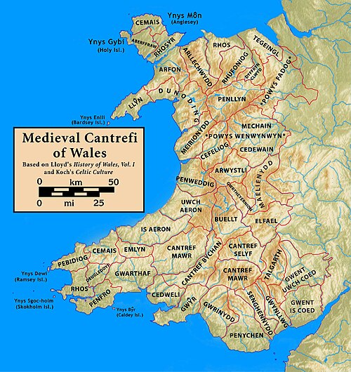
Medieval cantrefi of Wales
Southern Schleswig
Videos
Photos
Southern Schleswig is the southern half of the former Duchy of Schleswig in Germany on the Jutland Peninsula. The geographical area today covers the large area between the Eider river in the south and the Flensburg Fjord in the north, where it borders Denmark. Northern Schleswig, congruent with the former South Jutland County, forms the southernmost part of Denmark. The area belonged to the Crown of Denmark until Prussia and Austria declared war on Denmark in 1864. Denmark wanted to give away the German-speaking Holsten and set the new border at the small river Ejderen. Prussian chancellor Otto von Bismarck concluded that this justified a war, and even proclaimed it a "holy war". He also turned to the Emperor of Austria, Franz Joseph I of Austria for help. A similar war in 1848 had gone poorly for the Prussians. With Prussia's modern weapons and the help from both the Austrians and General Moltke, the Danish army was destroyed or forced to make a disorderly retreat. The Prussian-Danish border was then moved from the Elbe up in Jutland to the Kongeåen creek.

Residence of the Danish kings at Glücksburg Castle

Learn Danish banner in Flensburg, one of the major cities of Southern Schleswig