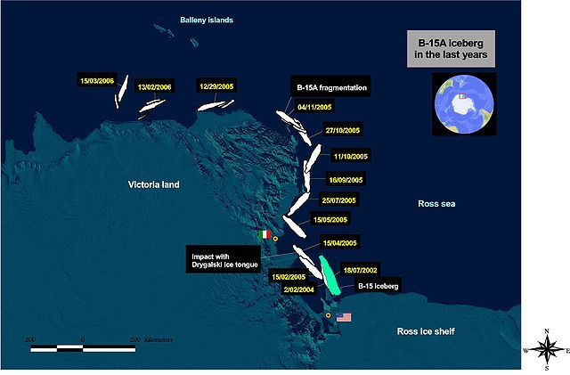
Iceberg B-15 was the largest recorded iceberg by area. It measured around 295 by 37 kilometres, with a surface area of 11,000 square kilometres, about the size of the island of Jamaica. Calved from the Ross Ice Shelf of Antarctica in March 2000, Iceberg B-15 broke up into smaller icebergs, the largest of which was named Iceberg B-15-A. In 2003, B-15A drifted away from Ross Island into the Ross Sea and headed north, eventually breaking up into several smaller icebergs in October 2005. In 2018, a large piece of the original iceberg was steadily moving northward, located between the Falkland Islands and South Georgia Island. As of August 2023, the U.S. National Ice Center (USNIC) still lists one extant piece of B-15 that meets the minimum threshold for tracking. This iceberg, B-15AB, measures 20 km × 7 km ; it is currently grounded off the coast of Antarctica in the western sector of the Amery region.
Northern edge of Iceberg B-15A in the Ross Sea, Antarctica, 29 January 2001
Iceberg B-15A four-year journey, July 2002 to March 2006
Researchers installing weather and GPS instruments on Iceberg B-15A, 29 January 2001
Iceberg B-15A drifting toward the Drygalski Ice Tongue before the collision, 2 January 2005 (NASA)
The Ross Ice Shelf is the largest ice shelf of Antarctica. It is several hundred metres thick. The nearly vertical ice front to the open sea is more than 600 kilometres (370 mi) long, and between 15 and 50 metres high above the water surface. Ninety percent of the floating ice, however, is below the water surface.
Crevasse, Ross Ice Shelf in 2001
"The mystic Barrier" at Bay of Whales, near where Amundsen first encountered it. Note humans for size comparison (dark spots at left between large chunks of sea ice, near the left image border). RV Nathaniel B. Palmer is in the distance.
The edge of the Ross Ice Shelf in 1997
Main drill site for the New Zealand 2017 hot water drill camp on the Ross Ice Shelf


