Ius Chasma is a large canyon in the Coprates quadrangle of Mars at 7° south latitude and 85.8° west longitude. It is about 938 km long and was named after a classical albedo feature name.
Ius Chasma in mosaic of THEMIS infrared images, with parts of Tithonium, Candor and Melas chasmata visible at upper left and right, extreme upper right, and extreme lower right, respectively. Side canyons created by sapping are prominent in the central region. Near the right end are a series of massive landslide deposits, the Ius Labes. Calydon Fossa, a smaller parallel chasm, runs south of Ius Chasma at left.
Ius Chasma, as seen by HiRISE. Click on image to see layers.
Ius Chasma Floor Layers, as seen by HiRISE. Scale bar is 500 meters long.
Ius Chasma Mesa, as seen by HiRISE. Scale bar is 500 meters long.
The Coprates quadrangle is one of a series of 30 quadrangle maps of Mars used by the United States Geological Survey (USGS) Astrogeology Research Program. The Coprates quadrangle is also referred to as MC-18. The Coprates quadrangle contains parts of many of the old classical regions of Mars: Sinai Planum, Solis Planum, Thaumasia Planum, Lunae Planum, Noachis Terra, and Xanthe Terra.
Image of the Coprates Quadrangle (MC-18). The prominent Valles Marineris chasma system intersects the moderately cratered northern part and the faulted highland ridged plains in the southern part.
Wide view of Mars centered on Valles Marineris, taken with Viking images. Note: this picture will greatly enlarge by clicking on it several times.
Melas Chasma, as seen by THEMIS. Click on image to see relationship of Melas Chasma to other features.
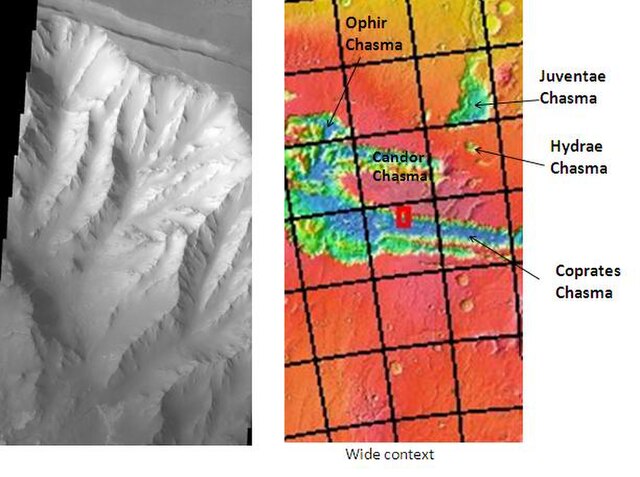
Cliff in Candor Chasma Plateau, as seen by THEMIS. Click on image to see relationship with other features in Coprates quadrangle.