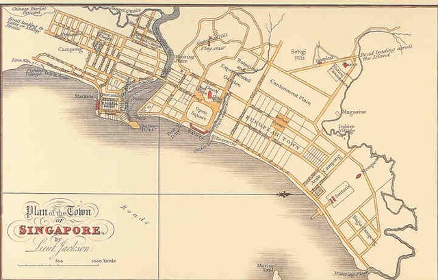
The Jackson Plan or Raffles Town Plan, an urban plan of 1822 titled "Plan of the Town of Singapore", is a proposed scheme for Singapore drawn up to maintain some order in the urban development of the fledgling but thriving colony founded just three years earlier. It was named after Lieutenant Philip Jackson, the colony's engineer and land surveyor tasked to oversee its physical development in accordance with the vision of Stamford Raffles for Singapore, hence it is also commonly called Raffles Town Plan. Raffles gave his instructions in November 1822, the plan was then drawn up in late 1822 or early 1823 and published in 1828. It is the earliest extant plan for the town of Singapore, but not an actual street map of Singapore as it existed in 1822 or 1827 since the plan is an idealised scheme of how Singapore may be organised that was not fully realised. Nevertheless, it served as a guide for the development of Singapore in its early days, and the effect of the general layout of the plan is still observable to this day.
Plan of the Town of Singapore, more commonly known as the Jackson Plan or Raffles Town Plan
The plan as first published by John Crawfurd in 1828
Philip Jackson (surveyor)
Philip Jackson was a British Royal Navy lieutenant in the Bengal Regiment Artillery. Jackson has also served as assistant engineer, executive officer and surveyor of public lands in colonial Singapore and laid out the city plan for Singapore in 1822. He was a key person in Raffles plans for the settlement and the Elgin Bridge in Singapore was once named in his honour.
Plan of Singapore drawn up by Jackson under instruction from Raffles
A sketch of Singapore by Philip Jackson in June 1823. It is the oldest surviving drawing of a view of the settlement on Singapore.


