Jefferson Davis Highway
Videos
Photos
The Jefferson Davis Highway, also known as the Jefferson Davis Memorial Highway, was a transcontinental highway in the United States in the 1910s and 1920s that began in Arlington, Virginia, and extended south and west to San Diego, California; it was named for Jefferson Davis, President of the Confederate States, United States senator, and Secretary of War. Because of unintended conflict between the National Auto Trail movement and the federal government, it is unclear whether it ever really existed in the complete form that its United Daughters of the Confederacy (UDC) founders originally intended.

Highway in Dublin, Georgia

Jefferson Davis Highway marker in Gretna, Louisiana, 2008

Irwin County, Georgia

Jefferson Davis Highway Marker from Blaine Washington, now displayed at Jefferson Davis Park outside Ridgefield, Washington
U.S. Route 1
Videos
Photos
U.S. Route 1 or U.S. Highway 1 (US 1) is a major north–south United States Numbered Highway that serves the East Coast of the United States. It runs 2,370 miles (3,810 km) from Key West, Florida, north to Fort Kent, Maine, at the Canadian border, making it the longest north–south road in the United States. US 1 is generally paralleled by Interstate 95 (I-95), though US 1 is significantly farther west and inland between Jacksonville, Florida, and Petersburg, Virginia, while I-95 is closer to the coastline. In contrast, US 1 in Maine is much closer to the coast than I-95, which runs farther inland than US 1. The route connects most of the major cities of the East Coast from the Southeastern United States to New England, including Miami, Jacksonville, Augusta, Raleigh, Richmond, Washington, D.C., Baltimore, Philadelphia, Newark, New York City, New Haven, Providence, Boston, and Portland.
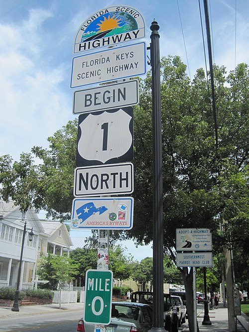
Mile 0, Key West, Florida

US 1 crossing Moser Channel along the Overseas Highway, Florida Keys

US 1 along Biscayne Boulevard in downtown Miami, Florida

Skyline of Augusta, Georgia, as seen from US 1 in North Augusta near I-520