Joint Base Anacostia–Bolling
Joint Base Anacostia–Bolling (JBAB) is a 905-acre (366 ha) military installation, located in Southwest Washington, D.C., established on 1 October 2010 in accordance with congressional legislation implementing the recommendations of the 2005 Base Realignment and Closure Commission. The legislation ordered the consolidation of Naval Support Facility Anacostia and Bolling Air Force Base (BAFB), which were adjoining but separate military installations into a single joint base, one of twelve formed in the country as a result of the law. The base hosts the Defense Intelligence Agency Headquarters amongst its other responsibilities. The only aeronautical facility at the base is a 100-by-100-foot helipad.
View of Joint Base Anacostia–Bolling from across the Potomac River during 2013.
Bolling Field and Anacosta Naval Air Station, mid-1940s
The last fixed-wing flight out of Bolling Air Force Base, 1962.
Southwest (Washington, D.C.)
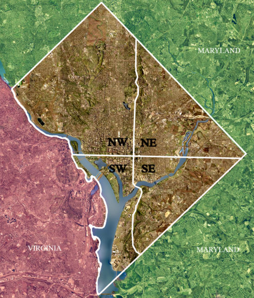
Southwest is the southwestern quadrant of Washington, D.C., the capital of the United States, and is located south of the National Mall and west of South Capitol Street. It is the smallest quadrant of the city, and contains a small number of named neighborhoods and districts, including Bellevue, Southwest Federal Center, the Southwest Waterfront, Buzzard Point, and the military installation known as Joint Base Anacostia–Bolling.
Color-enhanced USGS satellite image of Washington, D.C., with the crosshairs in the image marking the quadrant divisions of Washington, D.C., with the U.S. Capitol at the center of the dividing lines. To the west of the Capitol is the National Mall, visible as a slight green band in the image. The Southwest quadrant is the smallest, located mostly on a fairly narrow strip of land along the Potomac River, which is the large river running from the upper left corner to the bottom center of the image.
Fort McNair, a United States Army post in Southwest
12th St. tunnel under I-395 in Southwest
L'Enfant Plaza in Southwest


