Karoo
Videos
The Karoo is a semidesert natural region of South Africa. No exact definition of what constitutes the Karoo is available, so its extent is also not precisely defined. The Karoo is partly defined by it
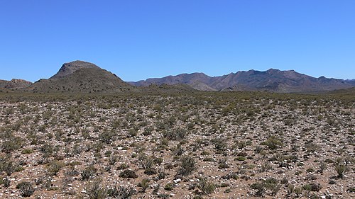
Typical Karoo vegetation to the south of Matjiesfontein, with the Anysberg Mountains visible in the background

A view from the top of the Great Escarpment in the Karoo National Park near Beaufort West, looking south across the plains of the Lower Karoo: Note the remnants and extent of the former central plateau on the plain below the escarpment (see diagram on the right). Also note the dolerite sills which top the escarpment and mountains in the middle distance, giving these structures their characteristic flat-topped appearance.

A stylized illustration of the Great Escarpment, based particularly on its appearance in the Great Karoo, where thick erosion resistant dolerite sills (see below; represented here by the thick black lines. The thinner dolerite sills are not drawn in this diagram to avoid clutter) generally form the upper, sharp edge of the escarpment. (In other parts of the escarpment, hard erosion-resistant geological layers similarly form the upper, abrupt edge.) Note the island remnants of the earlier extent of the plateau on the plain below the escarpment (the Lower Karoo), left behind as the escarpment has gradually eroded further inland.

Farmlands along the well-watered, fertile foothills of the plus 2,000 m (6,600 ft) high Swartberg Mountains (in the background) along the northern strip of the Klein Karoo
South Africa
Videos
South Africa, officially the Republic of South Africa, is the southernmost country in Africa. The country consists of nine provinces, and is bounded to the south by 2,798 kilometres of coastline that
Karoo
…south of the Great Escarpment up to Beaufort West. Thereafter, they gradually ascend the Great Escarpment along a broad valley to Three Sisters on the Central Plateau and the Upper Karoo. Turning north from the N1 between Touws River and Beaufort West, at Matjiesfontein, the road ascends the Great Escarpment through…

Front of Maropeng at the Cradle of Humankind

Mapungubwe Hill, the site of the former capital of the Kingdom of Mapungubwe

Portuguese explorer Bartolomeu Dias planting the cross at Cape Point after being the first to successfully round the Cape of Good Hope

Charles Davidson Bell's 19th-century painting of Jan van Riebeeck, who founded the first European settlement in South Africa, arriving in Table Bay in 1652