Adelaide
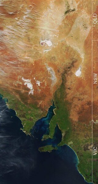
Adelaide is the capital city of the state of South Australia, the fifth-most populous city of Australia. In June 2017, Adelaide had an estimated resident population of 1,333,927. Adelaide is home to more than 75 percent of the South Australian population, making it the most centralised population of any state in Australia. Adelaide is north of the Fleurieu Peninsula, on the Adelaide Plains between the Gulf St Vincent and the low-lying Mount Lofty Ranges which surround the city. Adelaide stretches 20 km from the coast to the foothills, 94 to 104 km from Gawler at its northern extent to Sellicks Beach in the south. Named in honour of Adelaide of Saxe-Meiningen, queen consort to King William IV, the city was founded in 1836 as the planned capital for a freely-settled British province in Australia. Colonel William Light, one of Adelaide's founding fathers, designed the city and chose its location close to the River Torrens, in the area inhabited by the Kaurna people. Light's design set out Adelaide in a grid layout, interspaced by wide boulevards and large public squares, surrounded by parklands.
Early Adelaide was shaped by wealth. Until the Second World War, it was Australia's third-largest city and one of the few Australian cities without a convict history, it has been noted for early examples of religious freedom, a commitment to political progressivism and civil liberties. It has been known as the "City of Churches" since the mid-19th century, referring to its diversity of faiths rather than the piety of its denizens; the demonym "Adelaidean" is used in reference to its residents. As South Australia's seat of government and commercial centre, Adelaide is the site of many governmental and financial institutions. Most of these are concentrated in the city centre along the cultural boulevard of North Terrace, King William Street and in various districts of the metropolitan area. Today, Adelaide is noted for its many festivals and sporting events, its food and wine, its long beachfronts, its large defence and manufacturing sectors, it ranks in terms of quality of life, being listed in the world's top 10 most liveable cities, out of 140 cities worldwide by The Economist Intelligence Unit.
It was ranked the most liveable city in Australia by the Property Council of Australia in 2011, 2012 and 2013. Before its proclamation as a British settlement in 1836, the area around Adelaide was inhabited by the indigenous Kaurna Aboriginal nation. Kaurna culture and language were completely destroyed within a few decades of European settlement of South Australia, but extensive documentation by early missionaries and other researchers has enabled a modern revival of both. South Australia was proclaimed a British colony on 28 December 1836, near The Old Gum Tree in what is now the suburb of Glenelg North; the event is commemorated in South Australia as Proclamation Day. The site of the colony's capital was surveyed and laid out by Colonel William Light, the first Surveyor-General of South Australia, through the design made by the architect George Strickland Kingston. Adelaide was established as a planned colony of free immigrants, promising civil liberties and freedom from religious persecution, based upon the ideas of Edward Gibbon Wakefield.
Wakefield had read accounts of Australian settlement while in prison in London for attempting to abduct an heiress, realised that the eastern colonies suffered from a lack of available labour, due to the practice of giving land grants to all arrivals. Wakefield's idea was for the Government to survey and sell the land at a rate that would maintain land values high enough to be unaffordable for labourers and journeymen. Funds raised from the sale of land were to be used to bring out working-class emigrants, who would have to work hard for the monied settlers to afford their own land; as a result of this policy, Adelaide does not share the convict settlement history of other Australian cities like Sydney, Melbourne and Hobart. As it was believed that in a colony of free settlers there would be little crime, no provision was made for a gaol in Colonel Light's 1837 plan, but by mid-1837 the South Australian Register was warning of escaped convicts from New South Wales and tenders for a temporary gaol were sought.
Following a burglary, a murder, two attempted murders in Adelaide during March 1838, Governor Hindmarsh created the South Australian Police Force in April 1838 under 21-year-old Henry Inman. The first sheriff, Samuel Smart, was wounded during a robbery, on 2 May 1838 one of the offenders, Michael Magee, became the first person to be hanged in South Australia. William Baker Ashton was appointed governor of the temporary gaol in 1839, in 1840 George Strickland Kingston was commissioned to design Adelaide's new gaol. Construction of Adelaide Gaol commenced in 1841. Adelaide's early history was marked by questionable leadership; the first governor of South Australia, John Hindmarsh, clashed with others, in particular the Resident Commissioner, James Hurtle Fisher. The rural area surrounding Adelaide was surveyed by Light in preparation to sell a total of over 405 km2 of land. Adelaide's early economy started to get on its feet in 1838 with the arrival of livestock from Victoria, New South Wales and Tasmania.
Wool production provided an early basis for the South Australian economy. By 1860, wheat farms had been established from Encounter Bay in the south to Clare in the north. George Gawler took over from Hindmarsh in late 1838 and, despite being under orders from the Select Committee on South Australia in Britain not to undertake any public works, promptly oversaw construction of a governo
Kangaroo Island
Kangaroo Island is Australia's third-largest island, after Tasmania and Melville Island. It lies in the state of South Australia 112 km southwest of Adelaide, its closest point to the mainland is Snapper Point in Backstairs Passage, 13.5 km from the Fleurieu Peninsula. Once occupied by Aboriginal Australians, the native population disappeared from the archaeological record when the land became an island following rising sea levels several thousand years ago, it was subsequently settled intermittently by sealers and whalers in the early 19th century, from 1836 on a permanent basis during the establishment of the colony of South Australia. Since the island's economy has been principally agricultural, with a southern rock lobster fishery and with tourism growing in importance; the largest town, the administrative centre, is Kingscote. The island has several nature reserves to protect the remnants of its natural vegetation and native animals, with the largest and best-known being Flinders Chase National Park at the western end.
The island is 145 kilometres long West/East and between 0.94 and 54 km from its narrowest to widest North/South points. Its area covers 4,405 km2, its coastline is 540 km long and highest point is Mount MacDonnell at 299 m above sea level. It is separated from Yorke Peninsula to the northwest by Investigator Strait and from Fleurieu Peninsula to the northeast by Backstairs Passage. A group of islets, the Pages, lie off the eastern end of the island. Kangaroo Island separated from mainland Australia around 10,000 years ago, due to rising sea level after the last glacial period. Known as Karta by the mainland Aboriginal tribes, the existence of stone tools and shell middens show that Aboriginal people once lived on Kangaroo Island, it is thought that they occupied it as long ago as 16,000 years before the present, may have only disappeared from the island as as 2000 years ago. A mainland Aboriginal dreaming story tells of the Backstairs Passage flooding: "Long ago, Ngurunderi's two wives ran away from him, he was forced to follow them.
He as he did so he crossed Lake Albert and went along the beach to Cape Jervis. When he arrived there he saw his wives wading half-way across the shallow channel which divided Naroongowie from the mainland, he was determined to punish his wives, angrily ordered the water to rise up and drown them. With a terrific rush the waters roared and the women were carried back towards the mainland. Although they tried frantically to swim against the tidal wave they were powerless to do so and were drowned." On 23 March 1802, British explorer Matthew Flinders, commanding HMS Investigator, named the land "Kanguroo Island", due to the endemic subspecies of the western grey kangaroo, Macropus fuliginosus fuliginosus, after landing near Kangaroo Head on the north coast of the Dudley Peninsula. He was followed by the French explorer Commander Nicolas Baudin, the first European to circumnavigate the Island and who mapped much of the island. Although the French and the British were at war at the time, the men met peacefully.
They both used the fresh water seeping at what is now known as Hog Bay near Frenchman's Rock and the site of present-day Penneshaw. Baudin named the Island Île Borda, in honour of Jean-Charles de Borda, although the French chart published by Louis de Freycinet after Baudin's death referred to the Island as Île Decres. A community of sealers and others existed on Kangaroo Island from 1802 to the time of South Australia's colonisation in 1836. A sealing gang led by Joseph Murrrell are reported landing at Harvey's Return in 1806–07 and they established a camp on the beach; the sealers were rough men and several kidnapped Aboriginal women from Tasmania and mainland South Australia. The women were kept prisoner as virtual slaves. At least two contemporary accounts report of reputed crossings of Backstairs Passage from Kangaroo Island to the mainland by kidnapped women seeking to escape from their captors.'A fine specimen of her race' was pointed out to J. W. Bull as having swum the passage in 1835, a woman and her baby were found dead on the beach after a presumed crossing in 1871.
In 1803 sealers from the American brig Union built the schooner Independence, the first ship constructed in South Australia, at what is now American River. In 1812 Richard Siddins reached Kangaroo Island with the ship Campbell Macquarie, engaged in salt harvesting on the island. Most ships of the "First Fleet of South Australia" that brought settlers for the new colony first stopped at Nepean Bay; the first was the Duke of York commanded by Captain Robert Clark Morgan on 27 or 28 July 1836. The arrival of the Africaine, under John Finlay Duff, in November that year, was notable for the deaths of E. W. Osborne and Dr. John Slater, who perished on an exploratory trek from Cape Borda to Kingscote. A number of shore-based bay whaling stations operated on the coast in the 1840s; these were located at D'Estrees Bay and Hog Bay. Numerous ships have been wrecked on the Kangaroo Island coastline, the largest being Portland Maru of 5,865 tons, which sank at Cape Torrens on 20 March 1935; the greatest loss of life occurred with the wreck of Loch Sloy on 24 April 1899 at Maupertuis Bay, when 31 people were drowned, one initial survivor subsequently perished.
Twenty-seven people drowned at West Bay in September 1905. The first lighthouse built was erected at Cape Willoughby in 1852.
Precipitation
In meteorology, precipitation is any product of the condensation of atmospheric water vapor that falls under gravity. The main forms of precipitation include drizzle, sleet, snow and hail. Precipitation occurs when a portion of the atmosphere becomes saturated with water vapor, so that the water condenses and "precipitates", thus and mist are not precipitation but suspensions, because the water vapor does not condense sufficiently to precipitate. Two processes acting together, can lead to air becoming saturated: cooling the air or adding water vapor to the air. Precipitation forms as smaller droplets coalesce via collision with other rain drops or ice crystals within a cloud. Short, intense periods of rain in scattered locations are called "showers."Moisture, lifted or otherwise forced to rise over a layer of sub-freezing air at the surface may be condensed into clouds and rain. This process is active when freezing rain occurs. A stationary front is present near the area of freezing rain and serves as the foci for forcing and rising air.
Provided necessary and sufficient atmospheric moisture content, the moisture within the rising air will condense into clouds, namely stratus and cumulonimbus. The cloud droplets will grow large enough to form raindrops and descend toward the Earth where they will freeze on contact with exposed objects. Where warm water bodies are present, for example due to water evaporation from lakes, lake-effect snowfall becomes a concern downwind of the warm lakes within the cold cyclonic flow around the backside of extratropical cyclones. Lake-effect snowfall can be locally heavy. Thundersnow is possible within lake effect precipitation bands. In mountainous areas, heavy precipitation is possible where upslope flow is maximized within windward sides of the terrain at elevation. On the leeward side of mountains, desert climates can exist due to the dry air caused by compressional heating. Most precipitation is caused by convection; the movement of the monsoon trough, or intertropical convergence zone, brings rainy seasons to savannah climes.
Precipitation is a major component of the water cycle, is responsible for depositing the fresh water on the planet. 505,000 cubic kilometres of water falls as precipitation each year. Given the Earth's surface area, that means the globally averaged annual precipitation is 990 millimetres, but over land it is only 715 millimetres. Climate classification systems such as the Köppen climate classification system use average annual rainfall to help differentiate between differing climate regimes. Precipitation may occur on other celestial bodies, e.g. when it gets cold, Mars has precipitation which most takes the form of frost, rather than rain or snow. Precipitation is a major component of the water cycle, is responsible for depositing most of the fresh water on the planet. 505,000 km3 of water falls as precipitation each year, 398,000 km3 of it over the oceans. Given the Earth's surface area, that means the globally averaged annual precipitation is 990 millimetres. Mechanisms of producing precipitation include convective and orographic rainfall.
Convective processes involve strong vertical motions that can cause the overturning of the atmosphere in that location within an hour and cause heavy precipitation, while stratiform processes involve weaker upward motions and less intense precipitation. Precipitation can be divided into three categories, based on whether it falls as liquid water, liquid water that freezes on contact with the surface, or ice. Mixtures of different types of precipitation, including types in different categories, can fall simultaneously. Liquid forms of precipitation include drizzle. Rain or drizzle that freezes on contact within a subfreezing air mass is called "freezing rain" or "freezing drizzle". Frozen forms of precipitation include snow, ice needles, ice pellets and graupel; the dew point is the temperature to which a parcel must be cooled in order to become saturated, condenses to water. Water vapor begins to condense on condensation nuclei such as dust and salt in order to form clouds. An elevated portion of a frontal zone forces broad areas of lift, which form clouds decks such as altostratus or cirrostratus.
Stratus is a stable cloud deck which tends to form when a cool, stable air mass is trapped underneath a warm air mass. It can form due to the lifting of advection fog during breezy conditions. There are four main mechanisms for cooling the air to its dew point: adiabatic cooling, conductive cooling, radiational cooling, evaporative cooling. Adiabatic cooling occurs when air expands; the air can rise due to convection, large-scale atmospheric motions, or a physical barrier such as a mountain. Conductive cooling occurs when the air comes into contact with a colder surface by being blown from one surface to another, for example from a liquid water surface to colder land. Radiational cooling occurs due to the emission of infrared radiation, either by the air or by the surface underneath. Evaporative cooling occurs when moisture is added to the air through evaporation, which forces the air temperature to cool to its wet-bulb temperature, or until it reaches saturation; the main ways water vapor is added to the air are: wind convergence into areas of upward motion, precipitation or virga falling from above, daytime heating evaporating water from the surface of oceans, water bodies or wet lan
Encounter Bay
Encounter Bay is a bay in the Australian state of South Australia located on the state's south central coast about 100 kilometres south of the state capital of Adelaide. It was named by Matthew Flinders after his encounter on 8 April 1802 with Nicolas Baudin, the commander of the Baudin expedition of 1800–03, it is the site of the regional city of Victor Harbor. It is one of four ‘historic bays’ located on the South Australian coast. There are at least two definitions of the bay’s extent. Firstly, an American source states that Newland Head is its westerly extremity while the mouth of the River Murray is the easterly extremity. Secondly, Australian authorities consider the bay’s extent consists of all of the sea north of a line running east from the southern tip of Rosetta Head to the Younghusband Peninsula. Encounter Bay is one of four bays on the South Australian coast considered by the Australian government to be a ‘historic bay’ under the Seas and Submerged Lands Act 1973 and was proclaimed as such in 1987 and again in both 2006 and 2016, with the result that the mouth of the bay is on the territorial seas baseline and the waters within the bay are internal waters as per the definition used in United Nations Convention on the Law of the Sea.
Traditionally the land of the Ramindjeri clan of the Ngarrindjeri people, the bay's coastline is the site for the following settlements: Victor Harbor, Port Elliot and Goolwa. The Murray and Hindmarsh Rivers drain into the bay. Islands located within Encounter Bay include: Wright Island, Granite Island, Seal Island and Pullen Island. Encounter Bay was named by Matthew Flinders on 8 April 1802 after his encounter with Nicolas Baudin, both of whom were charting the Australian coastline for their respective countries; the encounter between the scientists was peaceful though they believed their countries were at war at the time. Shore-based bay whaling stations operated on the coast of Encounter Bay from June 1837 at Police Point, Granite Island and Rosetta Head; the last of these closed down in 1855. They were the longest lasting whaling stations in South Australia. An attempt was made to re-establish the fishery in 1871–72; the following protected areas exist within the bay’s waters: the Granite Island Recreation Park, the Pullen Island Conservation Park and the West Island Conservation Park, while the bay’s waters are within the boundaries of the Encounter Marine Park.
The following protected areas adjoin the shores of the bay: the Coorong National Park. Encounter Oceanic Victor Hodge, Charles Reynolds. Encounter Bay, the miniature Naples of Australia: a short history of the romantic south coast of South Australia. Hampstead Gardens, Adelaide, S. A.: Austaprint. ISBN 0-85872-320-4
Lands administrative divisions of Australia
Lands administrative divisions of Australia are the cadastral divisions of Australia for the purposes of identification of land to ensure security of land ownership. Most states term these divisions as counties, parishes and other terms; the eastern states of Queensland, New South Wales and Tasmania were divided into counties and parishes in the 19th century, although the Tasmanian counties were renamed land districts in the 20th century. Parts of South Australia and Western Australia were divided into counties, there were five counties in a small part of the Northern Territory; however South Australia has subdivisions of hundreds instead of parishes, along with the Northern Territory, part of South Australia when the hundreds were proclaimed. There were formerly hundreds in Tasmania. There have been at least 600 counties, 544 hundreds and at least 15,692 parishes in Australia, but there are none of these units for most of the sparsely inhabited central and western parts of the country. Counties in Australia have no administrative or political function, unlike those in England, the United States or Canada.
Australia instead uses local government areas, including shires, districts and municipalities according to the state, as the second-level subdivision. Some other states were divided into land divisions and land districts. Below these are groups of land parcels known as registered plans or title plans. Queensland has registered plans. Land can be identified using the number of this plan of subdivision held with the lands department, rather than with a named unit such as a parish. Within these are individual land parcels such as lots; the various cadastral units appear on certificates of title, which are given volume and folio numbers. Detailed maps of these divisions have been required since the introduction of the Torrens title system of a central register of land holdings in South Australia in 1858, which spread to the other colonies. While cadastral data since the 1980s has been digitalised, there remain many old maps showing these divisions held in collections of Australian libraries such as the National Library of Australia, as well as in state libraries.
Counties were used since the earliest British settlement in Australia, with the County of Cumberland proclaimed by Captain Phillip on 4 June 1788. In 1804 Governor King divided Van Diemen's Land into two counties; the parishes date to the surveys conducted after 1825, with the instructions given to Governor Brisbane on 23 Jun 1825 to divide the colony into counties and parishes. At this time there were five counties proclaimed in New South Wales: Cumberland, Camden and Northumberland; the Nineteen Counties in south-eastern New South Wales were the limits of location of the colony in a period after 1829, with the area outside them divided into districts, also into counties and parishes. Counties were established soon after the foundation of other Australian colonies. Many of the counties have English names the names of counties in England, such as Devon, Dorset and Kent Counties in Tasmania. Less some have Aboriginal names such as the County of Yungnulgra in New South Wales, County of Croajingolong in Victoria.
The use of counties and parishes was popular in Australia in the 19th century, with many maps of Australian colonies showing these divisions, towns and cities listed in their county. Legal cases referenced counties, many genealogical records for Australia in the 19th century list the county and parish for location of birth and marriages; the 1911 Britannica describes Australian towns and cities as being in their respective county, including most of the capital cities: Melbourne, County of Bourke. However it is not mentioned that Perth was located in the County of Perth, as by this time county names were infrequently used in Western Australia, where they did not cover all of the settled areas, unlike the other states. Instead the system of land divisions and land districts was used, with most of Perth located in the land districts of Swan and Cockburn Sound, all in the South West Land Division of Western Australia. Counties and parishes are still referenced in property law, in industrial relations instruments, for example in a New South Wales award, which excludes people from the County of Yancowinna.
Similar award examples exist in the other states and territories that have been subdivided into counties. The County of Yancowinna is the only part of New South Wales, in a different time zone to the rest of the state, as mentioned in the Australian Standard Time Act of 1987. Counties are used on paperwork for mortgage securities in banks. Parishes and counties are mentioned in definitions of electoral districts. Counties have since gone out of use in Australia, are used or known by most of the population today. Part of the reason is that counties are based on the size of land, rather than population, so in a large country
Mediterranean climate
A Mediterranean climate or dry summer climate is characterized by rainy winters and dry summers, with less than 40 mm of precipitation for at least three summer months. While the climate receives its name from the Mediterranean Basin, these are located on the western coasts of continents, between 30 and 45 degrees north and south of the equator between oceanic climates towards the poles, semi-arid and arid climates towards the equator. In essence, due to the seasonal shift of the subtropical high-pressure belts with the apparent movement of the Sun, a Mediterranean climate is an intermediate type between these other climates, with winters warmer and drier than oceanic climates and summers imitating sunny weather in semi-arid and arid climates; the resulting vegetation of Mediterranean climates are the garrigue or maquis in the Mediterranean Basin, the chaparral in California, the fynbos in South Africa, the mallee in Australia, the matorral in Chile. Areas with this climate are where the so-called "Mediterranean trinity" of agricultural products have traditionally developed: wheat and olive.
Most large, historic cities of the Mediterranean basin lie within Mediterranean climatic zones, including Algiers, Beirut, İzmir, Marseille, Rome and Valencia. Examples of major cities with Mediterranean climates that lie outside of the historic Mediterranean basin include major examples as Adelaide, Cape Town, Dushanbe, Los Angeles, Perth, San Francisco and Victoria. Under the Köppen climate classification, "hot dry-summer" climates and "cool dry-summer" climates are referred to as "Mediterranean". Under the Köppen climate system, the first letter indicates the climate group. Temperate climates or "C" zones have an average temperature above 0 °C, but below 18 °C, in their coolest months; the second letter indicates the precipitation pattern. Köppen has defined a dry summer month as a month with less than 30 mm of precipitation and with less than one-third that of the wettest winter month. Some, use a 40 mm level; the third letter indicates the degree of summer heat: "a" represents an average temperature in the warmest month above 22 °C, while "b" indicates the average temperature in the warmest month below 22 °C.
Under the Köppen classification, dry-summer climates occur on the western sides of continents. Csb zones in the Köppen system include areas not associated with Mediterranean climates but with Oceanic climates, such as much of the Pacific Northwest, much of southern Chile, parts of west-central Argentina, parts of New Zealand. Additional highland areas in the subtropics meet Cs requirements, though they, are not associated with Mediterranean climates, as do a number of oceanic islands such as Madeira, the Juan Fernández Islands, the western part of the Canary Islands, the eastern part of the Azores. Under Trewartha's modified Köppen climate classification, the two major requirements for a Cs climate are revised. Under Trewartha's system, at least eight months must have average temperatures of 10 °C or higher, the average annual precipitation must not exceed 900 mm. Thus, under this system, many Csb zones in the Köppen system become Do, the rare Csc zones become Eo, with only the classic dry-summer to warm winter, low annual rainfall locations included in the Mediterranean type climate.
During summer, regions of Mediterranean climate are influenced by cold ocean currents which keep the weather in the region dry and pleasant. Similar to desert climates, in many Mediterranean climates there is a strong diurnal character to daily temperatures in the warm summer months due to strong heating during the day from sunlight and rapid cooling at night. In winter, Mediterranean climate zones are no longer influenced by the cold ocean currents and therefore warmer water settles near land and causes clouds to form and rainfall becomes much more likely; as a result, areas with this climate receive all of their precipitation during their winter and spring seasons, may go anywhere from 3 to 6 months during the summer without having any significant precipitation. In the lower latitudes, precipitation decreases in both the winter and summer because they are closer to the Horse latitudes, thus bringing smaller amounts of rain. Toward the polar latitudes, total moisture increases; the rainfall tends to be more evenly distributed throughout the year in Southern Europe, while in the Eastern Mediterranean and in Southern California the summer is nearly or dry.
In places where evapotranspiration is higher, steppe climates tend to prevail, but still follow the weather pattern of the Mediterranean climate. The majority of the regions with Mediterranean climates have mild winters and warm summers; however winter and summer temperatures can vary between different regions with a Mediterranean climate. For instance, in the case of winters and Los Angeles experience mild temperatures in the winter, with frost and snowfall unknown, whereas Tashkent has colder winters with annual frosts and snowfall. Or to consider summer, Athens experiences rather high temperatures in that season. In contrast, San Francisco has cool summers with daily highs around 21 °C due to
Postcodes in Australia
Postcodes are used in Australia to more efficiently sort and route mail within the Australian postal system. Postcodes in Australia are placed at the end of the Australian address. Postcodes were introduced in Australia in 1967 by the Postmaster-General's Department and are now managed by Australia Post, are published in booklets available from post offices or online from the Australia Post website. Australian envelopes and postcards have four square boxes printed in orange at the bottom right for the postcode; these are used. Postcodes were introduced in Australia in 1967 by the Postmaster-General's Department to replace earlier postal sorting systems, such as Melbourne's letter and number codes and a similar system used in rural and regional New South Wales; the introduction of the postcodes coincided with the introduction of a large-scale mechanical mail sorting system in Australia, starting with the Sydney GPO. By 1968, 75% of mail was using postcodes, in the same year post office preferred-size envelopes were introduced, which came to be referred to as “standard envelopes”.
Postcode squares were introduced in June 1990 to enable Australia Post to use optical character recognition software in its mail sorting machines to automatically and more sort mail by postcodes. Australian postcodes consist of four digits, are written after the name of the city, suburb, or town, the state or territory: Mr John Smith 100 Flushcombe Road BLACKTOWN NSW 2148When writing an address by hand, a row of four boxes is pre-printed on the lower right hand corner of an envelope, the postcode may be written in the boxes. If addressing a letter from outside Australia, the postcode is recorded before'Australia'. Australian postcodes are sorting information, they are linked with one area. Due to post code rationalisation, they can be quite complex in country areas; the south-western Victoria 3221 postcode of the Geelong Mail Centre includes twenty places around Geelong with few people. This means that mail for these places is not sorted until it gets to Geelong; some postcodes cover large populations, while other postcodes have much smaller populations in urban areas.
Australian postcodes range from 0200 for the Australian National University to 9944 for Cannonvale, Queensland. Some towns and suburbs have two postcodes — one for street deliveries and another for post office boxes. For example, a street address in the Sydney suburb of Parramatta would be written like this: Mr John Smith 99 George Street PARRAMATTA NSW 2150But mail sent to a PO Box in Parramatta would be addressed: Mr John Smith PO Box 99 PARRAMATTA NSW 2124Many large businesses, government departments and other institutions receiving high volumes of mail had their own postcode as a Large Volume Receiver, e.g. the Royal Brisbane and Women's Hospital has the postcode 4029, the Australian National University had the postcode 0200. More postcode ranges were made available for LVRs in the 1990s. Australia Post has been progressively discontinuing the LVR programme since 2006; the first one or two numbers show the state or territory that the postcode belongs to Sometimes near the state and territory borders, Australia Post finds it easier to send mail through a nearby post office, across the border: Some of the postcodes above may cover two or more states.
For example, postcode 2620 covers both a locality in NSW as well as a locality in the ACT, postcode 0872 covers a number of localities across WA, SA, NT and QLD. Three locations straddle the NSW-Queensland border. Jervis Bay Territory, once an exclave of the ACT but now a separate territory, is geographically located on the coast of NSW, it is just south of the towns of Huskisson, with which it shares a postcode. Mail to the Jervis Bay Territory is still addressed to the ACT; the numbers used to show the state on each radio callsign in Australia are the same number as the first number for postcodes in that state, e.g. 2xx in New South Wales, 3xx in Victoria, etc. Radio callsigns pre-date postcodes in Australia by more than forty years. Australia's external territories are included in Australia Post's postcode system. While these territories do not belong to any state, they are addressed as such for mail sorting: Three scientific bases in Antarctica operated by the Australian National Antarctic Research Expeditions share a postcode with the isolated sub-Antarctic island of Macquarie Island: Each state's capital city ends with three zeroes, while territorial capital cities end with two zeroes.
Capital city postcodes were the lowest postcodes in their state or territory range, before new ranges for LVRs and PO Boxes were made available. The last number can be changed from "0" to "1" to get the postcode for General Post Office boxes in any capital city: While the first number of a postcode shows the state or territory, the second number shows a region within the state. However, postcodes with the same second number are not always next to each other; as an example, postcodes in the range 2200–2299 are split between the southern suburbs of Sydney and the Central Coast of New South Wales. Postcodes with a second number of "0" or "1" are always located within the metropolitan area of the state's capital city. Postcodes with higher secon