Ku-ring-gai Chase National Park is a national park on the northern side of Sydney in New South Wales, Australia. The 14,977-hectare (37,010-acre) park is 25 kilometres (16 mi) north of the Sydney central business district and generally comprises the land east of the M1 Pacific Motorway, south of the Hawkesbury River, west of Pittwater and north of Mona Vale Road. It includes Barrenjoey Headland on the eastern side of Pittwater.

The steep wooded ria that forms Towlers Bay, is typical of the Ku-ring-gai Chase terrain.

Tessellated pavement near the Elvina Track on the Park's Lambert Peninsular

Aboriginal rock engraving

Sphinx Memorial
Pittwater
Videos
Pittwater is a semi-mature tide dominated drowned valley estuary, located about 40 kilometres (25 mi) north of the Sydney central business district, New South Wales, Australia; being one of the bodies of water that separate greater Metropolitan Sydney from the Central Coast.
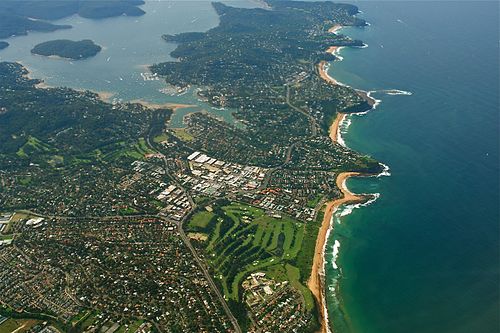
Aerial view of a part of Sydney's Northern Beaches, with Pittwater and Scotland Island on the left.

Sunset view west across Pittwater from Barrenjoey Head, showing Ku-ring-gai Chase National Park on the western shoreline.

View east across Pittwater from West Head, showing Barrenjoey Head, the southern head of the mouth of the Hawkesbury, and Palm Beach

Pittwater from Ku-ring-gai Chase National Park.