Lechitic languages
Videos
Photos
The Lechitic languages are a language subgroup consisting of Polish and several other languages and dialects that were once spoken in the area that is now Poland and eastern Germany. It is one of the branches of the larger West Slavic subgroup; the other branches of this subgroup are the Czech–Slovak languages and the Sorbian languages.

Kashubian jamboree in Łeba in 2005 – banner showing the Kashubian name of Kartuzy County
Polish language
Videos
Photos
Polish is a West Slavic language of the Lechitic group within the Indo-European language family written in the Latin script. It is primarily spoken in Poland and serves as the official language of the country, as well as the language of the Polish diaspora around the world. In 2023, there were over 40.6 million Polish native speakers. It ranks as the sixth most-spoken among languages of the European Union. Polish is subdivided into regional dialects and maintains strict T–V distinction pronouns, honorifics, and various forms of formalities when addressing individuals.
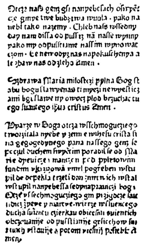
The oldest printed text in Polish – Statuta synodalia Episcoporum Wratislaviensis printed in 1475 in Wrocław by Kasper Elyan.

A formal-tone informative sign in Polish, with a composition of vowels and consonants and a mixture of long, medium and short syllables

The Jakub Wujek Bible in Polish, 1599 print. The letters á and é were subsequently abolished, but survive in Czech.

Common handbag in Polish is called a torba, a word directly derived from the Turkish language. Turkish loanwords are common as Poland bordered the Ottoman Empire for centuries.[failed verification]