Macquarie Triple Junction
The Macquarie Triple Junction is a geologically active tectonic boundary located at 61°30′S 161°0′E at which the historic Indo-Australian Plate, Pacific Plate, and Antarctic Plate collide and interact. The term Triple Junction is given to particular tectonic boundaries at which three separate tectonic plates meet at a specific, singular location. The Macquarie Triple Junction is located on the seafloor of the southern region of the Pacific Ocean, just south of New Zealand. This tectonic boundary was named in respect to the nearby Macquarie Island, which is located southeast of New Zealand.

Figure 1: The present Macquarie Triple Junction portrays the three most common oceanic tectonic boundaries. The first is Emerald Fracture Zone, a leaky transform fault, which is the region between A and A’. The second is the Southeast Indian Ridge, located just west of the MTJ and is split by the Balleny Fault Zone, identified by the letter B. And lastly the Hjort Trench which is represented by C. The Macquarie microplate occupies an illdefined southern region of the area labelled as the Indio-australian Plate which for the last 3 million years has been a separate
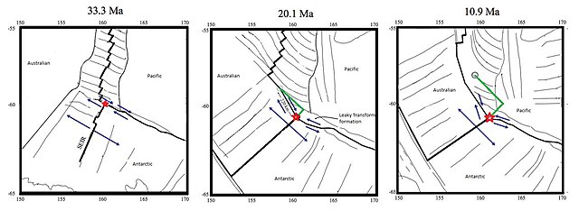
Figure 2: The evolution of the Macquarie Triple Junction has been well studied dating back to 33.3 Mya and has been reconstructed in at 20.1 Mya and 10.9 Mya. The green line shows the migration distance between intervals. The label Australian refers to the Indo-Australian Plate at the times illustrated.
The 1,600 kilometres (990 mi) long Macquarie Fault Zone is a major right lateral-moving transform fault along the seafloor of the south Pacific Ocean which runs from New Zealand southwestward towards the Macquarie Triple Junction. It is also the tectonic plate boundary between the Australian Plate to the northwest and the Pacific Plate to the southeast. As such it is a region of high seismic activity and recorded the largest strike-slip event on record up to May 23, 1989, of at least Mw8.0
The evolution of the Macquarie Triple Junction over the last approximately 33 to 10 million years has involved to its north the southern portion of the Macquarie Fault Zone. The green line on the diagram shows the migration distance between time intervals.