Mauna Kea
Videos
Mauna Kea is a dormant shield volcano on the island of Hawaiʻi. Its peak is 13,803 feet above sea level, making it the highest point in Hawaii and the island with the second highest high point, behind

Mauna Kea in December 2007, with its seasonal snow cap visible

Lava flows from Mauna Loa caught by one of the International Gemini Observatory's Cloudcams, which operates 24/7 near the snow-covered summit of Maunakea (the highest point in the image).(on 27 November 2022).
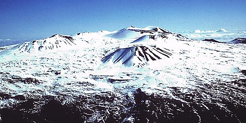
Scoria and cinder cones on Mauna Kea's summit in winter

Glacial evidence on Mauna Kea, outlining terminal moraines ("m") and till ("w")
Hawaiʻi (island)
Videos
Hawaiʻi, sometimes written Hawaii, is the largest island in the United States, located in the state of Hawaii. It is the southeasternmost of the Hawaiian Islands, a chain of volcanic islands in the No
Mauna Kea
…Mauna Kea (, Hawaiian: ; abbreviation for Mauna a Wākea, 'White Mountain') is a dormant shield volcano on the island of Hawaiʻi. Its peak is 13,803 feet (4,207.3 meters) above sea level, making it the highest point in Hawaii and the island with the second highest high point…

The Ahu-a-ʻUmi Heiau, built for ʻUmi-a-Līloa in the Kona District

Hawaiian and European ships in Kealakekua Bay in 1829

Aerial view, 3D computer-generated image

A view of the Kohala Coast and adjacent volcanoes, taken from the slopes of Kohala, about 6 miles (10 km) northwest of Kawaihae. From left to right: Mauna Kea, Mauna Loa, and Hualālai.