Mauna Loa
Videos
Mauna Loa is one of five volcanoes that form the Island of Hawaii in the U.S. state of Hawaii in the Pacific Ocean. Mauna Loa is Earth's largest active volcano by both mass and volume. It was historically considered to be the largest volcano on Earth until Tamu Massif was discovered to be larger. Mauna Loa is a shield volcano with relatively gentle slopes, and a volume estimated at 18,000 cubic miles (75,000 km3), although its peak is about 125 feet (38 m) lower than that of its neighbor, Mauna Kea. Lava eruptions from Mauna Loa are silica-poor and very fluid, and tend to be non-explosive.

Mauna Loa as seen from the air. Hualālai is visible in the background.

Landsat mosaic; recent lava flows appear in black

Mauna Loa from Hilo Bay, December 2017

Mauna Loa's summit, overlaid with 100 m (328 ft) contour lines; its rift zones are visible from the air.
Shield volcano
Videos
A shield volcano is a type of volcano named for its low profile, resembling a shield lying on the ground. It is formed by the eruption of highly fluid lava, which travels farther and forms thinner flows than the more viscous lava erupted from a stratovolcano. Repeated eruptions result in the steady accumulation of broad sheets of lava, building up the shield volcano's distinctive form.

An Ancient Greek warrior's shield—its circular shape and gently sloping surface, with a central raised area, is a shape shared by many shield volcanoes.

ʻAʻa advances over solidified pāhoehoe on Kīlauea, Hawaiʻi
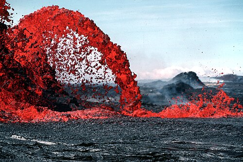
A pāhoehoe lava fountain on Kīlauea erupts